Distance Measuring Equipment
Distance Measuring Equipment is a measuring device using ground and air components to determine the slant range of an aircraft from a point.
Introduction to Distance Measuring Equipment
- Distance Measuring Equipment (DME) is a measuring device using ground and air components to determine the slant range of an aircraft from a point.
- DME equipment functions by using paired radio signals between the aircraft and ground stations.
Distance Measuring Equipment Key Highlights
- Distance Measuring Equipment (DME) provides pilots with slant-range distance information from a ground-based navigation station.
- DME systems operate by measuring the time required for radio signals to travel between aircraft equipment and ground stations.
- DME commonly works with VOR, ILS, and TACAN navigation facilities to improve positional awareness and route navigation.
- Distance information is typically displayed in nautical miles along with groundspeed and estimated time-to-station calculations.
- Slant-range distance reflects the direct distance between the aircraft and the station rather than horizontal ground distance.
- DME accuracy improves as aircraft altitude decreases relative to the station during terminal operations.
- Pilots use DME information for instrument approaches, holding procedures, route fixes, and en route navigation.
- Modern RNAV and GPS systems often supplement or replace traditional DME navigation capabilities.
- Navigation accuracy depends on proper equipment operation, station identification, and signal reception quality.
- Understanding DME operation improves navigation precision, situational awareness, and overall flight safety.
Distance Measuring Equipment Function
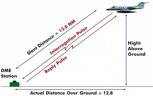
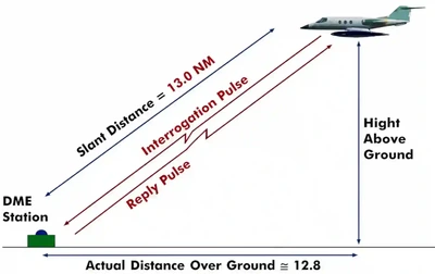
- Paired pulses at specific spacing (interrogation) are sent to a ground station from the aircraft via the antenna. []
- The ground station (transponder) sends the same pulses back to the aircraft at a different frequency.
- Time time it takes is interpreted as the distance, usually in Nautical Miles (NM).
- Distance is measured in slant range (not horizontal range!) but some units can correct this.
- Slant range error minimized at lower altitudes.
- Operates on the line-of-site principle.
- Reliable up to 199 NM accuracy of better than 1/2 mile or 3% of the distance, whichever is greater (more accurate).
- Due to the limited number of available frequencies, assignment of paired frequencies is required for certain military non-collocated VOR and TACAN facilities which serve the same area but which may be separated by distances up to a few miles.
- DME is not available on a VOR and would require a separate receiver.
- DME paired with a VOR constitutes a VORTAC.
- Can be identified every 30 seconds or about every 3rd to 4th VOR identification.
- Required above FL 240 when VOR navigation required (under IFR) as per FAR 91.205(e).
- If DME fails above FL 240, continue to next airport where repairs or equipment replacement can be done (must still report as per AIM 5-3-3).
- GS values, if displayed, are only accurate when flying directly to / from the station
- Service volume applies:
- Note that Standard Service Volume (SSV) does not apply to airways as they've been certified at their respective distances.
Frequency:
- 960 MHz to 1215 MHz in accordance with ICAO Annex 10.
Frequency Pairing
- VOR/DME, VORTAC, Instrument Landing System (ILS)/DME, and localizer (LOC)/DME navigation facilities established by the FAA provide course and distance information from collocated components under a frequency pairing plan.
- Aircraft receiving equipment which provides for automatic DME selection assures reception of azimuth and distance information from a common source when designated VOR/DME, VORTAC, ILS/DME, and LOC/DME are selected.
- Due to the limited number of available frequencies, assignment of paired frequencies is required for certain military non-collocated VOR and TACAN facilities which serve the same area but which may be separated by distances up to a few miles.
Identification of Distance Measuring Equipment Stations
- VOR/DME, VORTAC, ILS/DME, and LOC/DME facilities are identified by synchronized identifications which are transmitted on a time share basis.
- The VOR or localizer portion of the facility is identified by a coded tone modulated at 1020 Hz or a combination of code and voice.
- The TACAN or DME is identified by a coded tone modulated at 1350 Hz.
- The DME or TACAN coded identification is transmitted one time for each three or four times that the VOR or localizer coded identification is transmitted.
- When either the VOR or the DME is inoperative, it is important to recognize which identifier is retained for the operative facility.
- A single coded identification with a repetition interval of approximately 30 seconds indicates that the DME is operative.
- Aircraft equipment which provides for automatic DME selection assures reception of azimuth and distance information from a common source when designated VOR/DME, VORTAC and ILS/DME navigation facilities are selected.
- Pilots are cautioned to disregard any distance displays from automatically selected DME equipment when VOR or ILS facilities, which do not have the DME feature installed, are being used for position determination.
Slaved Compass Systems
- Aircraft equipped with slaved compass systems may be susceptible to heading errors caused by exposure to magnetic field disturbances (flux fields) found in materials that are commonly located on the surface or buried under taxiways and ramps.
- These materials generate a magnetic flux field that can be sensed by the aircraft's compass system flux detector or "gate," which can cause the aircraft's system to align with the material's magnetic field rather than the earth's natural magnetic field.
- The system's erroneous heading may not self-correct.
- Prior to take off pilots should be aware that a heading misalignment may have occurred during taxi.
- Pilots are encouraged to follow the manufacturer's or other appropriate procedures to correct possible heading misalignment before take off is commenced.
Distance Measuring Equipment Knowledge Check


Distance Measuring Equipment Conclusion
- DME stations are their own set of equipment, and are not necessarily part of the NAVAID, hence association with various other ground-based systems like VORs and localizers.
- DME is therefore not an indication the NAVAID it is tied to is in service.
- Aircraft equipped with TACAN equipment will receive distance information from a VORTAC automatically, while aircraft equipped with VOR must have a separate DME airborne unit.
- Note, GPS-based guidance is an acceptable substitute for most uses of ground-based navaids (i.e., if DME is out-of-service), except for lateral guidance on the final approach segment, unless the navaid is in service and can be monitored simultaneously.
- Still looking for something? Continue searching:
Distance Measuring Equipment References
- Federal Aviation Administration - Pilot/Controller Glossary.
- Aeronautical Information Manual (1-1-7) Distance Measuring Equipment (DME).
- Aeronautical Information Manual (5-3-3) Additional Reports.
- Federal Aviation Regulations (91.205) Powered civil aircraft with standard category U.S. airworthiness certificates: Instrument and equipment requirements.
- Instrument Flying Handbook (7-16) Distance Measuring Equipment (DME).