Navigation & Flight Planning
Successful flights rarely happen by chance—they are the result of careful preparation and sound planning. Understanding navigation techniques and flight planning methods helps pilots determine routes, fuel requirements, and alternates while maintaining situational awareness throughout the flight.
Radio Aids to Navigation
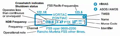
- On VFR Charts, information about radio aids to navigation (NAVAID) is boxed, as illustrated
- When two or more radio aids in a general area have the same name with different frequencies, Tactical Air Navigation (TACAN) channel numbers, or identification letters, and no misinterpretation can result, the name of the radio aid may be indicated only once within the identification box
- Very High Frequency/Ultra High Frequency (VHF/UHF) Navigation Aid (NAVAID) names and identification boxes (shown in blue) take precedence
- Only those items that differ (e.g., frequency, Morse Code) are repeated in the box in the appropriate color
- The choice of separate or combined boxes is made in each case on the basis of economy of space and clear identification of the radio aids
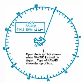
- A NAVAID that is physically located on an airport may not always be represented as a typical NAVAID symbol
- A small open circle indicates the NAVAID location when collocated with an airport icon
- The type of NAVAID will be identified by: "VOR," (VHF Omni-Directional Range) "VORTAC" (VOR Tactical Aircraft Control) or "VORDME," (VOR-Distance Measuring Equipment) positioned on and breaking the top line of the NAVAID box
Navigation
- Flight outside of the local area requires some degree of Flight Planning
- Aviation is inherently unpredictable, requiring adaptability
- Certain instances will call for a change of plans and diversions
- Charts
- VFR Cross-Country Flight
- IFR Enroute Charts
- Area Navigation
- Required Navigation Performance (RNP)


Flight Plans
- Flight plans are a result of the deliberate planning process which results in a tool for both the pilot and Air Traffic Control
- Completed and filed on the FAA Form 7233-1, flight plans provide basic times and locations to track flights and manage traffic
- Flight plans come in a variety of forms:
-
Civilian Flight Plans:
-
Military Flight Plans:
-
International Flight Plans:
-

IFR Alternate Airports
- IFR alternate airport data is published in the U.S. Chart Supplement
Navigation & Flight Planning Conclusion
- The FAA provides reliable data within the U.S.
- Outside of the U.S., the FAA disclaims that pilots must refer to charts from host countries for situational awareness for detailed and accurate non-U.S. data
- Inaccuracies internationally result form non-timely data received by the FAA from the host nation and incompatibility with some services like the Notice to Airmen system
- Courses are available such as the AOPA's Air Safety Institute Know Before You Go - Navigating Today's Airspace
- Still looking for something? Continue searching:
- Resources, such as AOPA's Know Before You Go: Navigating Today's Airspace, is available to help learn about the national airspace system and how to best navigate through it
- Global Air provides suggestions on international flight requirements