VFR & IFR Flight Plans
Filing a flight plan helps ensure that a pilot’s intended route and timing are known before departure. Understanding VFR and IFR flight plans helps pilots recognize the differences in services, requirements, and operational benefits associated with each type of plan.
Introduction to VFR & IFR Flight Plans
- Flight Plans are the product of thorough flight planning, as written intentions from the pilot to Air Traffic Control (ATC) for the intended flight
- This plan ensures you receive Search and Rescue (SAR) protection in case of the worst
There are five types of flight plans:
- With a flight plan properly filled out, you will then need to file the flight plan
- Depending on your operation, you will need to select an alternate airport
VFR & IFR Flight Plans Key Highlights
- VFR and IFR flight plans provide operational information that supports air traffic services, search and rescue coordination, and flight management.
- VFR flight plans are optional for most domestic operations but improve search and rescue response if an aircraft becomes overdue.
- IFR flight plans are required for operations conducted under instrument flight rules within controlled airspace.
- Flight plans typically include route information, aircraft identification, departure and destination airports, fuel endurance, and estimated times.
- Pilots must activate and close VFR flight plans appropriately to ensure search and rescue services function correctly.
- IFR flight plans allow air traffic control to provide separation services, routing, and traffic management throughout instrument operations.
- Accurate flight plan information improves operational coordination and reduces communication errors during flight.
- Modern Electronic Flight Bags (EFBs) and flight planning systems simplify filing, modifying, and managing flight plans.
- Changes in weather, routing, fuel status, or operational conditions may require flight plan amendments during flight operations.
- Understanding VFR and IFR flight plans improves operational preparedness, situational awareness, and overall flight safety.
Flight Planning
- Flight planning is the process of becoming familiar with all facets of a flight
- This process ultimately produces necessary information to complete the FAA Form 7233-1 flight plan and if done properly, meets the requirement for FAR 91.103, preflight planning

VFR Flight Plans
- VFR Flight Plans enhance operations conducted under VFR
- The requirements for the filing and activation of VFR flight plans can vary depending in which airspace the flight is operating
- Within the continental U.S., a VFR flight plan is not normally required
- VFR flights (except for DOD and law enforcement flights) into an Air Defense Identification Zone (ADIZ), and hence international flights, are required to file DVFR flight plans
- Flights within the Washington, DC Special Flight Rules Area have additional requirements
- Visit https://www.faasafety.gov for the required Special Awareness Training that must be completed before flight within this area
-
Filing VFR Flight Plans:
- It is strongly recommended that a VFR flight plan be filed with a Flight Service Station or equivalent flight plan filing service
- When filing, pilots must use FAA Form 7233-4, International Flight Plan or DD Form 1801
- Only DOD users, and civilians who file stereo route flight plans, may use FAA Form 7233-1, Flight Plan
- Pilots may take advantage of advances in technology by filing their flight plans using any available electronic means
- VFR flight plan proposals are normally retained for two hours following the proposed time of departure, unless:
- The actual departure time is received
- A revised proposed departure time is received
- At a time of filing, the FSS is informed the proposed/assumed departure time will be met but actual time cannot be given because of inadequate communications
- This assumed departure time will cause the flight plan to become active at the designated time
- This may negate the need for communication with a flight service station or flight plan filing service upon departure
- It is the pilot's responsibility to revise his actual departure time, time en route, or ETA with flight service, as search and rescue services are based upon the assumed departure time
- When filing a VFR Flight plan, indicate the appropriate aircraft equipment capability as prescribed for an IFR flight plan
- Under some circumstances, ATC computer tapes can be useful in constructing the radar history of a downed or crashed aircraft
- In each case, knowledge of the aircraft's transponder equipment is necessary in determining whether or not such computer tapes might prove effective
- Under some circumstances, ATC computer tapes can be useful in constructing the radar history of a downed or crashed aircraft
- When a stopover flight is anticipated, it is recommended that a separate flight plan be filed for each leg of the flight
- Pilots may file a flight plan by falling flight service or by using the automated flight plan tool on https://www.1800wxbrief.com/Website/#!/
-
Activating VFR Flight Plans:
- Pilots are responsible for activating flight plans with a Flight Service Station
- Control tower personnel do not automatically activate VFR flight plans
- Pilots are encouraged to activate their VFR flight plans with Flight Service by the most expeditious means possible
- This may be via radio or other electronic means
- Pilots are encouraged to give their departure times directly to the FSS serving the departure airport or as otherwise indicated by the FSS when the flight plan is filed
- This will ensure more efficient flight plan service and permit the FSS to advise you of significant changes in aeronautical facilities or meteorological conditions
- On pilot's request, at a location having an active tower, the aircraft identification will be forwarded by the tower to the FSS for reporting the actual departure time
- This request should be avoided at busy airports, to avoid further increase of controller workloads
- In the case of a busy tower, contact the nearest flight service station upon departure
- Activating the flight plan will ensure that you receive VFR Search and Rescue services
- Pilots are responsible for activating flight plans with a Flight Service Station
-
Flying on VFR Flight Plans:
- Although position reports are not required for VFR flight plans, periodic reports to FSSs along the route are good practice
- Such contacts permit significant information to be passed to the transiting aircraft and also serve to check the progress of the flight should it be necessary for any reason to locate the aircraft
- Pilot: "[Callsign], over Kingfisher at [Time], VFR flight plan, [Departure Airport] to [Destination Airport]"
- Example: "Bonanza 314K, over Kingfisher at 1109, VFR flight plan, Tulsa to Amarillo"
- Pilot: "[Callsign], over Oklahoma City at [Time], Shreveport to Denver, no flight plan"
- Example: "Cherokee 5133J, over Oklahoma City at 0920, Shreveport to Denver, no flight plan"
- Such contacts permit significant information to be passed to the transiting aircraft and also serve to check the progress of the flight should it be necessary for any reason to locate the aircraft
- Pilots flying VFR should fly an appropriate cruising altitude for their direction of flight
- Although position reports are not required for VFR flight plans, periodic reports to FSSs along the route are good practice
-
Closing VFR Flight Plans:
- A pilot is responsible for ensuring the VFR/DVFR flight plan is closed
- Close the flight plan with the nearest FSS, or if not available, any ATC can relay your cancellation to an FSS
- Towers do not normally close VFR/DVFR flight plans because they don't know if a particular aircraft is on a flight plan or not
- If you fail to report or cancel your flight plan within 30 minutes after your ETA, SAR procedures begin
IFR Flight Plans
- Use of FAA Form 7233-4 or DD Form 1801 is mandatory for:
- Assignment of RNAV SIDs and STARs or other PBN routing,
- All civilian IFR flights that will depart U.S. domestic airspace, and
- Domestic IFR flights except military/DOD and civilians who file stereo route flight plans
- All military/DOD IFR flights that will depart U.S. controlled airspace
- Military/DOD flights using FAA Form 7233-1, or DD Form 175, may not be eligible for assignment of RNAV SIDs or STARs. Military flights desiring assignment of these procedures should file using FAA Form 7233-4 or DD 1801
- When filing an IFR flight plan using FAA Form 7233-4 or DD Form 1801, it is recommended that filers include all operable navigation, communication, and surveillance equipment capabilities by adding appropriate equipment qualifiers
- ATC issues clearances based on aircraft capabilities filed in Items 10 and 18 of FAA Form 7233-4 or DD 1801
- Operators should file all capabilities for which the aircraft and crew is certified, capable, and authorized
- PBN/capability must be filed in Item 18, Other Information
- When filing a capability, ATC expects filers to use that capability; for example, answer a SATVOICE call from ATC if code M1 or M3 is filed in Item 10
- Prior to departure from within, or prior to entering controlled airspace, a pilot must submit a complete flight plan and receive an air traffic clearance, if weather conditions are below VFR minimums
- IFR flight plans may be submitted to an FSS or flight plan filing service
- When requesting an IFR clearance, it is highly recommended that the departure airport be identified by stating the city name and state and/or the airport location identifier in order to clarify to ATC the exact location of the intended airport of departure
- With cell phone use and flight service specialists covering larger areas of the country, clearly identifying the departure airport can prevent confusing your airport of departure with those of identical or similar names in other states
- Multiple versions of flight plans for the same flight may lead to unsafe conditions and errors within the air traffic system
- Pilots must not file more than one flight plan for the same flight without ensuring that the previous flight plan has been successfully removed
- When a pilot is aware that the possibility for multiple flight plans on the same aircraft may exist, ensuring receipt of a full route clearance will help mitigate chances of error
-
Filing IFR Flight Plans:
- Pilots should file IFR flight plans at least 30 minutes prior to estimated time of departure to preclude possible delay in receiving a departure clearance from ATC
- In order to provide FAA traffic management units' strategic route planning capabilities, nonscheduled operators conducting IFR operations above FL 230 are requested to voluntarily file IFR flight plans at least four hours prior to estimated time of departure (ETD)
- To minimize your delay in entering Class B, Class C, Class D, and Class E surface areas at destination when IFR weather conditions exist or are forecast at that airport, an IFR flight plan should be filed before departure
- Otherwise, a 30-minute delay is not unusual in receiving an ATC clearance because of time spent in processing flight plan data
- Traffic saturation frequently prevents control personnel from accepting flight plans by radio
- In such cases, the pilot is advised to contact a flight plan filing service for the purpose of filing the flight plan
- Additionally, mistakes can be easily made over the radio
-
Activating IFR Flight Plans:
- Unlikely VFR Flight Plans, IFR Flight Plans are activated automatically by ATC
- IFR Flight Plans are typically activated upon departure with tower however, at uncontrolled airfields they will become active upon contact of the departure frequency received as part of the clearance
-
Flying on IFR Flight Plans:
- In addition to altitude or flight level, destination and/or route changes, increasing or decreasing the airspeed by plus or minus 5% or 10 knots (whichever is greater) constitutes a change in a flight plan
-
Closing IFR Flight Plans:
- Can be canceled in VFR and out of class A airspace
- IFR flight plans may be closed at any time with either ARTCC, approach control, tower, or if unable, with FSS
- When landing at an airport with a functioning control tower, IFR flight plans are automatically canceled
- If landing at a non-towered aircraft, ensure the flight plan is closed by contacting FSS
-
Airways and Jet Routes Depiction on Flight Plan:
- It is vitally important that the route of flight be accurately and completely described in the flight plan
- To simplify definition of the proposed route, and to facilitate ATC, pilots are requested to file via airways or jet routes established for use at the altitude or flight level planned
- If flight is to be conducted via designated airways or jet routes, describe the route by indicating the type and number designators of the airway(s) or jet route(s) requested
- If more than one airway or jet route is to be used, clearly indicate points of transition
- If the transition is made at an unnamed intersection, show the next succeeding NAVAID or named intersection on the intended route and the complete route from that point
- Reporting points may be identified by using authorized name/code as depicted on appropriate aeronautical charts
- The following two examples illustrate the need to specify the transition point when two routes share more than one transition fix
- ALB J37 BUMPY J14 BHM Spelled out: from Albany, New York, via Jet Route 37 transitioning to Jet Route 14 at BUMPY intersection, thence via Jet Route 14 to Birmingham, Alabama
- ALB J37 ENO J14 BHM Spelled out: from Albany, New York, via Jet Route 37 transitioning to Jet Route 14 at Smyrna VORTAC (ENO) thence via Jet Route 14 to Birmingham, Alabama
- The route of flight may also be described by naming the reporting points or NAVAIDs over which the flight will pass, provided the points named are established for use at the altitude or flight level planned
- BWI V44 SWANN V433 DQO Spelled out: from Baltimore-Washington International, via Victor 44 to Swann intersection, transitioning to Victor 433 at Swann, thence via Victor 433 to Dupont
- When the route of flight is defined by named reporting points, whether alone or in combination with airways or jet routes, and the navigational aids (VOR, VORTAC, TACAN, NDB) to be used for the flight are a combination of different types of aids, enough information should be included to clearly indicate the route requested
- LAX J5 LKV J3 GEG YXC FL 330 J500 VLR J515 YWG Spelled out: from Los Angeles International via Jet Route 5 Lakeview, Jet Route 3 Spokane, direct Cranbrook, British Columbia VOR/DME, Flight Level 330 Jet Route 500 to Langruth, Manitoba VORTAC, Jet Route 515 to Winnipeg, Manitoba
- When filing IFR, it is to the pilot's advantage to file a preferred route which are described and tabulated in the Chart Supplement U.S. [Figure 2]
- Additionally available at U.S. https://www.fly.faa.gov/Products/Coded_Departure_Routes/NFDC_Preferred_Routes_Database/nfdc_preferred_routes_database.html
- ATC may issue a SID or a STAR, as appropriate
- Pilots not desiring an RNAV SID or RNAV STAR should enter in Item #18, PBN code: NAV/RNV A0 and/or D0
- It is vitally important that the route of flight be accurately and completely described in the flight plan
-
Direct Flights:
- All or any portions of the route which will not be flown on the radials or courses of established airways or routes, such as direct route flights, must be defined by indicating the radio fixes over which the flight will pass. Fixes selected to define the route must be those over which the position of the aircraft can be accurately determined. Such fixes automatically become compulsory reporting points for the flight, unless advised otherwise by ATC. Only those navigational aids established for use in a particular structure; i.e., in the low or high structures, may be used to define the en route phase of a direct flight within that altitude structure
- The azimuth feature of VOR aids and the azimuth and distance (DME) features of VORTAC and TACAN aids are assigned certain frequency protected areas of airspace which are intended for application to established airway and route use, and to provide guidance for planning flights outside of established airways or routes. These areas of airspace are expressed in terms of cylindrical service volumes of specified dimensions called "class limits" or "categories"
- An operational service volume has been established for each class in which adequate signal coverage and frequency protection can be assured. To facilitate use of VOR, VORTAC, or TACAN aids, consistent with their operational service volume limits, pilot use of such aids for defining a direct route of flight in controlled airspace should not exceed the following:
- Operations above FL 450 - Use aids not more than 200 NM apart. These aids are depicted on en route high altitude charts
- Operation off established routes from 18,000 feet MSL to FL 450 - Use aids not more than 260 NM apart. These aids are depicted on en route high altitude charts
- Operation off established airways below 18,000 feet MSL - Use aids not more than 80 NM apart. These aids are depicted on en route low altitude charts
- Operation off established airways between 14,500 feet MSL and 17,999 feet MSL in the conterminous U.S. - (H) facilities not more than 200 NM apart may be used
- Increasing use of self-contained airborne navigational systems which do not rely on the VOR/VORTAC/TACAN system has resulted in pilot requests for direct routes which exceed NAVAID service volume limits
- At times, ATC will initiate a direct route in a surveillance environment which exceeds NAVAID service volume limits. Pilots must adhere to the altitude specified in the clearance
- Appropriate airway or jet route numbers may also be included to describe portions of the route to be flown
- Example: MDW V262 BDF V10 BRL STJ SLN GCK Spelled out: from Chicago Midway Airport via Victor 262 to Bradford, Victor 10 to Burlington, Iowa, direct St. Joseph, Missouri, direct Salina, Kansas, direct Garden City, Kansas
- When route of flight is described by radio fixes, the pilot will be expected to fly a direct course between the points named
- Pilots are reminded that they are responsible for adhering to obstruction clearance requirements on those segments of direct routes that are outside of controlled airspace
- The MEAs and other altitudes shown on low altitude IFR enroute charts pertain to those route segments within controlled airspace, and those altitudes may not meet obstruction clearance criteria when operating off those routes
-
Area Navigation/Global Navigation Satellite System:
- When not being radar monitored, GNSS-equipped RNAV aircraft on random RNAV routes must be cleared via or reported to be established on a point-to-point route
- The points must be published NAVAIDs, waypoints, fixes or airports recallable from the aircraft's navigation database
- The points must be displayed on controller video maps or depicted on the controller chart displayed at the control position
- When applying non-radar separation the maximum distance between points must not exceed 500 miles
- ATC will protect 4 miles either side of the route centerline
- Assigned altitudes must be at or above the highest MIA along the projected route segment being flown, including the protected airspace of that route segment
- The points must be published NAVAIDs, waypoints, fixes or airports recallable from the aircraft's navigation database
- Pilots of aircraft equipped with approved area navigational equipment may file for RNAV routes throughout the National Airspace System in accordance with the following procedures:
- File airport-to-airport flight plans
- File the appropriate indication of RNAV and/or RNP capability in the flight plan
- Plan the random route portion of the flight plan to begin and end over appropriate arrival and departure transition fixes or appropriate navigation aids for the altitude stratum within which the flight will be conducted. The use of normal preferred departure and arrival routes (DP/STAR), where established, is recommended
- File route structure transitions to and from the random route portion of the flight
- Define the random route by waypoints. File route description waypoints by using degree-distance fixes based on navigational aids which are appropriate for the altitude stratum
- File a minimum of one route description waypoint for each ARTCC through whose area the random route will be flown
- These waypoints must be located within 200 NM of the preceding center's boundary
- This requirement is of particular use to Air Traffic Control during an ATC-Alert, ATC-Limited, and ATC-Zero
- File an additional route description waypoint for each turn-point in the route
- Plan additional route description way-points as required to ensure accurate navigation via the filed route of flight. Navigation is the pilot's responsibility unless ATC assistance is requested
- Plan the route of flight so as to avoid prohibited and restricted airspace by 3 NM unless permission has been obtained to operate in that airspace and the appropriate ATC facilities are advised
- To be approved for use in the National Airspace System, RNAV equipment must meet system availability, accuracy, and airworthiness standards. For additional information and guidance on RNAV equipment requirements see Advisory Circular (AC) 20-138 Airworthiness Approval of Positioning and Navigation Systems and AC 90-100 U.S. Terminal and En Route Area Navigation (RNAV) Operations
- Greater detail can be found under the Area Navigation section
-
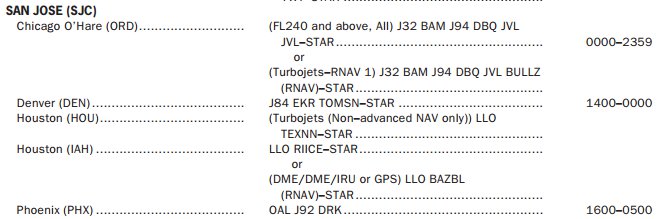
Chart Supplement U.S. Preferred Route Listings
- Pilots of aircraft equipped with latitude/longitude coordinate navigation capability, independent of VOR/TACAN references, may file for random RNAV using the following procedures:
- File airport-to-airport flight plans prior to departure
- File the appropriate RNAV capability certification suffix in the flight plan
- Plan the random route portion of the flight to begin and end over published departure/arrival transition fixes or appropriate navigation aids for airports without published transition procedures. The use of preferred departure and arrival routes, such as DP and STAR where established, is recommended
- Plan the route of flight so as to avoid prohibited and restricted airspace by 3 NM unless permission has been obtained to operate in that airspace and the appropriate ATC facility is advised
- Define the route of flight after the departure fix, including each intermediate fix (turnpoint) and the arrival fix for the destination airport in terms of latitude/longitude coordinates plotted to the nearest minute or in terms of Navigation Reference System (NRS) waypoints. For latitude/ longitude filing the arrival fix must be identified by both the latitude/longitude coordinates and a fix identifier
- Example: MIA1 SRQ2 3407/106153 3407/11546 TNP4 LAX5
- Departure airport
- Departure fix
- Intermediate fix (turning point)
- Arrival fix
- Destination airport
- Example: ORD1 IOW2 KP49G3 KD34U4 KL16O5 OAL6 MOD27 SFO8
- Departure airport
- Transition fix (pitch point)
- 3inneapolis ARTCC waypoint
- Denver ARTCC Waypoint
- Los Angeles ARTCC waypoint (catch point)
- Transition fix
- Arrival
- Destination airport
- Example: MIA1 SRQ2 3407/106153 3407/11546 TNP4 LAX5
- Record latitude/longitude coordinates by two or four figures describing latitude in degrees followed by an N or S, followed by 3 or 5 digits longitude, followed by an E or W. Separate latitude and longitude with a solidus "/." Use leading zeros if necessary
- File at FL 390 or above for the random RNAV portion of the flight
- Fly all routes/route segments on Great Circle tracks or GPS tracks
- Make any in-flight requests for random RNAV clearances or route amendments to an en route ATC facility
- When not being radar monitored, GNSS-equipped RNAV aircraft on random RNAV routes must be cleared via or reported to be established on a point-to-point route
-
- VFR climbs on course streamlines departures used when visual meteorological conditions prevail in the local area.
- Enter the NAVAID or intersection, which will establish you on your route as the first entry in the "ROUTE-OF-FLIGHT" section of the flight plan
- ATC will issue instructions as to when to contact ARTCC for your IFR clearance
- Must write "request VFR climb on course" in the remarks section of the flight plan
- Remain below CLASS A airspace and fly VFR cruising altitudes until issued an IFR clearance
Flight Plans For Military/DOD-Use Only
- Within U.S. controlled airspace, FAA Form 7233-1 or DD Form 175 may be used by DOD aircraft
- However, use of the DD Form 1801 by DOD aircraft is recommended for IFR flights and is mandatory for:
- Any flight that will depart U.S. controlled airspace
- Any flight requesting routing that requires Performance Based Navigation
- Any flight requesting services that require filing of capabilities only supported in the international flight plan
- The order of flight plan elements in DD Form 175 is equivalent to that of FAA Form 7233-1
- Civilians who file stereo route flight plans, may use FAA Form 7233-1, Flight Plan
Single Flights Conducted With Both VFR and IFR Flight Plans
- Flight plans which combine VFR operation on an active VFR flight plan for one portion of a flight, and IFR for another portion, sometimes known as a composite flight plan, cannot be accepted or processed by current en route automation systems
- Pilots are free to operate VFR in VFR conditions prior to accepting an IFR clearance from the appropriate control facility, or may cancel an IFR clearance and proceed VFR as desired
- However, if a pilot desires to be on an active VFR flight plan, with search and rescue provisions, for the portion of flight not conducted under an IFR clearance, a separate VFR flight plan must be filed, activated, and closed
- If a pilot desires to be on an active VFR flight plan prior to or following the IFR portion of the flight, that flight plan must be filed and processed as a distinct and separate flight plan
- The VFR flight plan must be opened and closed with either a Flight Service Station or other service provider having the capability to open and close VFR flight plans
- Air Traffic Control does not have the ability to determine if an aircraft is operating on an active VFR flight plan and cannot process the activation or cancellation of a VFR flight plan
- Pilots may propose to commence the IFR portion of flight at a defined airborne point
- This airborne point, or fix, is entered as the departure point in Item 13 of FAA Form 7233-4 or DD Form 1801
- Pilots may indicate in the IFR flight plan the intention to terminate the IFR portion of flight at any defined airborne point
- The airborne point, or fix, is entered as the destination point in Item 16 of FAA Form 7233-4 or DD Form 1801
- Prior to beginning the IFR portion of flight, a pilot must receive an IFR clearance from the appropriate control facility
- If the pilot does not desire further clearance after reaching the clearance limit, he or she must advise ATC to cancel the IFR clearance
Defense VFR Flight Plan
- VFR flights (except DOD or law enforcement flights) into an ADIZ are required to file Defense VFR (DVFR) flight plans for security purposes
- More detailed information can be found under the National Security and Interception Procedures of the Aeronautical Information Manual
- Additionally you may reference 14 CFR Part 99
- DVFR flight plans must be filed using FAA Form 7233-4 or DD Form 1801
- Enter the letter "D" in Item 8, Type of Flight, of FAA Form 7233-4 or DD Form 1801
- DVFR flights where pilots decline search and rescue coverage must clearly indicate "NORIV" in Item 18 following the indicator "RMK/"
- This flight plan must still be activated in order to properly notify NORAD, however no flight plan cancellation will be expected
- For example, RMK/NORIV
RNAV and RNP Operations
- During the pre-flight planning phase the availability of the navigation infrastructure required for the intended operation, including any non-RNAV contingencies, must be confirmed for the period of intended operation
- Availability of the onboard navigation equipment necessary for the route to be flown must be confirmed
- Pilots are reminded that on composite VFR to IFR flight plan, or on an IFR clearance, while flying unpublished departures via RNAV into uncontrolled airspace, the PIC is responsible for terrain and obstruction clearance until reaching the MEA/MIA/MVA/OROCA
- OROCA is a published altitude which provides 1,000 feet of terrain and obstruction clearance in the U.S. (2,000 feet of clearance in designated mountainous areas). These altitudes are not assessed for NAVAID signal coverage, air traffic control surveillance, or communications coverage, and are published for general situational awareness, flight planning and in-flight contingency use
- If a pilot determines a specified RNP level cannot be achieved, revise the route or delay the operation until appropriate RNP level can be ensured
- The onboard navigation database must be current and appropriate for the region of intended operation and must include the navigation aids, waypoints, and coded terminal airspace procedures for the departure, arrival and alternate airfields
- During system initialization, pilots of aircraft equipped with a Flight Management System or other RNAV-certified system, must confirm that the navigation database is current, and verify that the aircraft position has been entered correctly. Flight crews should crosscheck the cleared flight plan against charts or other applicable resources, as well as the navigation system textual display and the aircraft map display. This process includes confirmation of the waypoints sequence, reasonableness of track angles and distances, any altitude or speed constraints, and identification of fly-by or fly-over waypoints. A procedure must not be used if validity of the navigation database is in doubt
- Prior to commencing takeoff, the flight crew must verify that the RNAV system is operating correctly and the correct airport and runway data have been loaded
- During the pre-flight planning phase RAIM prediction must be performed if TSO-C129() equipment is used to solely satisfy the RNAV and RNP requirement. GPS RAIM availability must be confirmed for the intended route of flight (route and time) using current GPS satellite information. In the event of a predicted, continuous loss of RAIM of more than five (5) minutes for any part of the intended flight, the flight should be delayed, canceled, or re-routed where RAIM requirements can be met. Operators may satisfy the predictive RAIM requirement through any one of the following methods:
- Operators may monitor the status of each satellite in its plane/slot position, by accounting for the latest GPS constellation status (for example, NOTAMs or NANUs), and compute RAIM availability using model-specific RAIM prediction software;
- Operators may use the Service Availability Prediction Tool (SAPT) on the FAA en route and terminal RAIM prediction website;
- Operators may contact a Flight Service Station to obtain non-precision approach RAIM;
- Operators may use a third party interface, incorporating FAA/VOLPE RAIM prediction data without altering performance values, to predict RAIM outages for the aircraft's predicted flight path and times;
- Operators may use the receiver's installed RAIM prediction capability (for TSO-C129a/Class A1/B1/C1 equipment) to provide non-precision approach RAIM, accounting for the latest GPS constellation status (for example, NOTAMs or NANUs). Receiver non-precision approach RAIM should be checked at airports spaced at intervals not to exceed 60 NM along the RNAV 1 procedure's flight track. "Terminal" or "Approach" RAIM must be available at the ETA over each airport checked; or,
- Operators not using model-specific software or FAA/VOLPE RAIM data will need FAA operational approval
- If TSO-C145/C146 equipment is used to satisfy the RNAV and RNP requirement, the pilot/operator need not perform the prediction if WAAS coverage is confirmed to be available along the entire route of flight. Outside the U.S. or in areas where WAAS coverage is not available, operators using TSO-C145/C146 receivers are required to check GPS RAIM availability

How to Complete a 7233-4 Flight Plan
- The FAA will accept a flight plan in international format for IFR, VFR, SFRA, and DVFR flights
- File the flight plan electronically via a Flight Service Station (FSS), FAA contracted flight plan filing service, or other commercial flight plan filing service
- Depending on the filing service chosen, the method of entering data may be different but the information required is generally the same
-
Addressee(s), Filing Time, and Originator:
- Address(s), filing time, and the originator section are completed by ATC, not the pilot
- Although not explicitly labeled item 1 and 2, this section serves as those blocks
-
Item 3 - Message Type:
Pre-filled out with >=(FPL to indicate a flight plan -
Item 7 - Aircraft Identification:
- Aircraft identification must not exceed seven alphanumeric characters and be either:
- The nationality or common mark and registration of the aircraft (for example, EIAKO, 4XBCD, N1727V), when:
- In radiotelephony, the call sign to be used by the aircraft will consist of this identification alone (for example, CGAJS) or preceded by the ICAO telephony designator for the aircraft operating agency (for example, BLIZZARD CGAJS); or
- The aircraft is not equipped with radio
- The ICAO designator for the aircraft operating agency, followed by the flight identification (for example, KLM511, NGA213, JTR25)
- When in radiotelephony the call sign to be used by the aircraft will consist of the ICAO telephony designator for the operating agency followed by the flight identification (for example, KLM511, NIGERIA213, JESTER25)
- The nationality or common mark and registration of the aircraft (for example, EIAKO, 4XBCD, N1727V), when:
- See Item 18 below for exceptions
- Aircraft identification must not exceed seven alphanumeric characters and be either:
-
Item 8 - Flight Rules/Type of Flight:
-
Flight Rules:
- Flight rules are always required and must indicate IFR (I) or VFR (V)
- For composite flight plans, submit separate flight plans for the IFR and VFR portions of the flight
- Specify in Item 15 the point or points where change of flight rules is planned
-
Type of Flight:
- The type of flight is optional for flights remaining wholly within U.S. domestic airspace
- International flights, including those that temporarily leave domestic U.S. airspace and return, indicate the type of flight as follows:
- G - General Aviation
- S - Scheduled Air Service
- N - Non-Scheduled Air Transport Operation
- M - Military
- X - other than any of the defined categories above
-
-
Item 9 - Number, Type, Wake Turbulence Category:
-
Number:
- Enter the number of aircraft when there is more than one aircraft in the flight; indicate the number of aircraft up to 99
-
Type:
- Provide the appropriate 2-4-character aircraft type designator listed in FAA Order 7360.1 - Aircraft Type Designators
- When there is no designator for the aircraft type use 'ZZZZ', and provide a description in Item 18 TYP/
-
Wake Turbulence Category:
- A Wake Turbulence Category is required for all aircraft types
- Provide the appropriate wake turbulence category for the aircraft type as listed in FAA Order 7360.1:
- J - SUPER: aircraft types specified as such in FAA Order JO 7360.1, Aircraft Type Designators
- H - HEAVY: to indicate an aircraft type with a maximum certificated take-off mass of 300,000 lbs. or more, with the exception of aircraft types listed in FAA Order JO 7360.1 in the SUPER (J) category
- M - MEDIUM: to indicate an aircraft type with a maximum certificated take-off mass of less than 300,000 lbs. but more than 15,500 lbs
- L - LIGHT: to indicate an aircraft type with a maximum certificated take-off mass of 15,500 lbs. or less
-
-
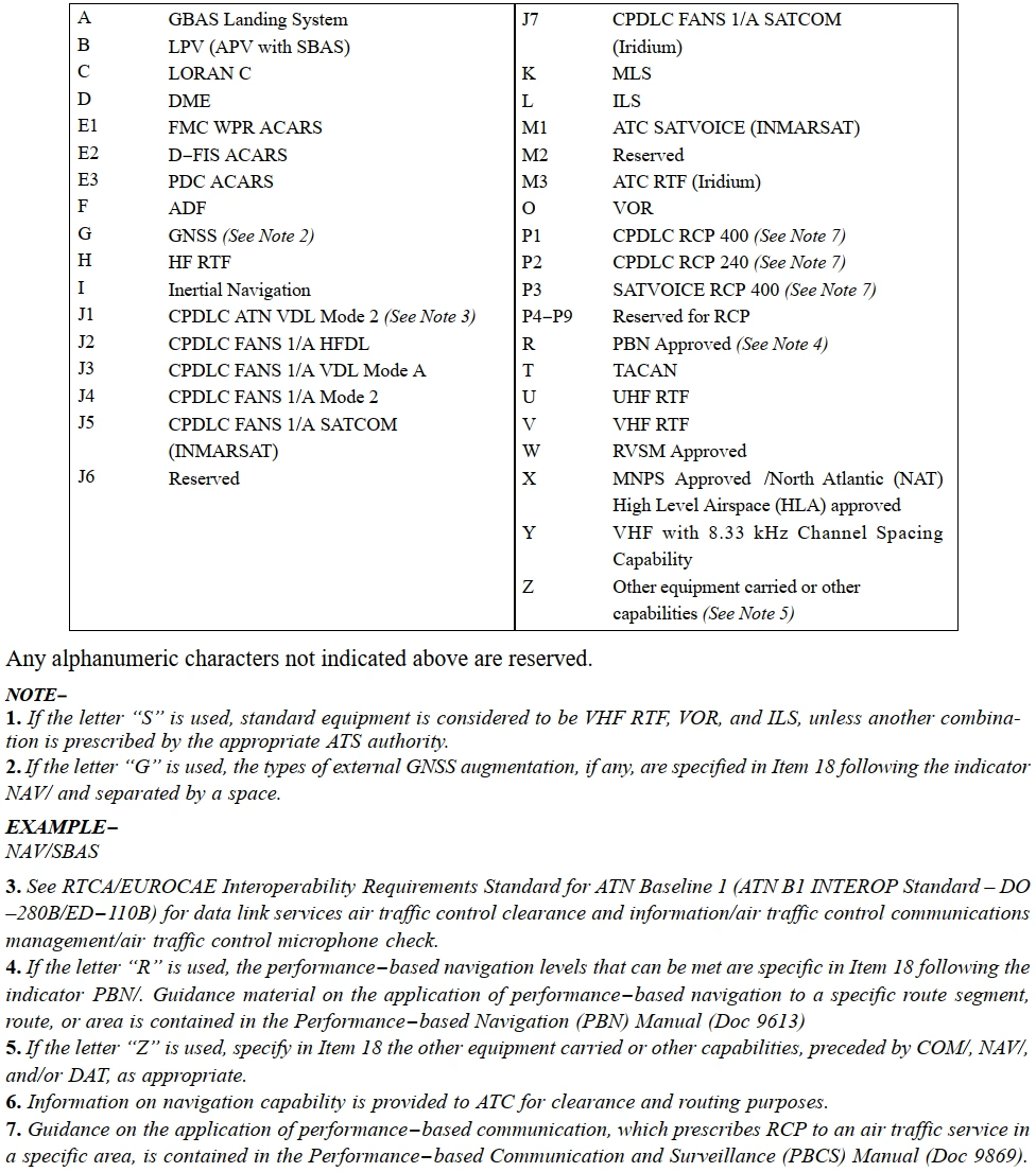
Item 10 - Equipment and Capabilities:
- Equipment and capabilities that can be filed in a flight plan include:
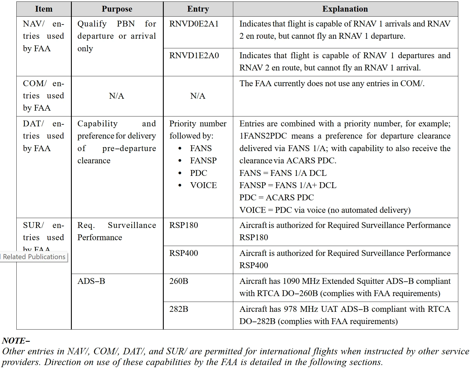
- Navigation capabilities in Item 10a, Item 18 PBN/, and Item 18 NAV/
- Voice communication capabilities in Item 10a and Item 18 COM/
- Data communication capabilities in Item 10a and Item 18 DAT/
- Approach capabilities in Item 10a and Item 18 NAV/
- Surveillance capabilities in Item 10b and Item 18 SUR/
- Radio communication, navigation and approach aid equipment and capabilities ENTER one letter as follows:
- N: if no COM/NAV/approach aid equipment for the route to be flown is carried, or the equipment is unserviceable, or;
- S: if standard COM/NAV/approach aid equipment for the route to be flown is carried and serviceable (see Note 1), and/or;
- Enter one or more of the following letters from [Figure 4/5] to indicate the serviceable COM/NAV/ approach aid equipment and capabilities available
- Equipment and capabilities that can be filed in a flight plan include:
-
Item 13 - Departure Aerodrome and Time:
-
Departure Aerodrome:
- The airport should be identified using the four-letter location identifier from FAA Order JO 7350.9, Location Identifiers, or from ICAO Document 7910
- FSS and FAA contracted flight plan filing services will allow up to 11 characters in the departure field
- FSS and FAA contracted flight plan filing services therefore permits entry of non-ICAO identifier airports, and other fixes such as an intersection, fix/radial/distance, and latitude/longitude coordinates
- Use of non-ICAO identifiers in Item 13 and Item 16 is only permissible when flight destination is within U.S. airspace
- If the destination is outside of the U.S., then both Item 13 and Item 16 must contain either a valid ICAO airport identifier or ZZZZ
- Use of non-ICAO departure point is not permitted in Item 13 if destination in Item 16 is outside of U.S.
- Other electronic filing services may require a different format
- FSS and FAA contracted flight plan filing services will allow up to 11 characters in the departure field
- When the intended departure airport (Item 13) is outside of domestic U.S. airspace, or if using the paper version of FAA Form 7233-4, or DOD equivalent, if the chosen flight plan filing service does not allow non-ICAO airport identifiers in Item 13 or Item 16, use the following ICAO procedure
- Enter four Z's (ZZZZ) in Item 13 and include the non-ICAO airport location identifier, fix, or waypoint location in Item 18 DEP/
- A text description following the location identifier is permissible in Item 18 DEP/
- The airport should be identified using the four-letter location identifier from FAA Order JO 7350.9, Location Identifiers, or from ICAO Document 7910
-
Departure Time:
- Indicate the expected departure time using 4 digits, 2 digits for hours and 2 digits for minutes
- Time is to be entered as Coordinated Universal Time (UTC)
-
-
Item 15 - Cruising Speed, Altitude/Level, and Route:
-
Cruising Speed:
- Include the requested cruising speed as True Airspeed in knots using an N followed by four digits
- For example: N0450 for 450 KTAS
- Indicate the requested cruising speed in Mach using an M followed by three digits
- For example: M081 for Mach 081
- Include the requested cruising speed as True Airspeed in knots using an N followed by four digits
-
Cruising Altitude/Level:
- Indicate a Requested Altitude in hundreds of feet using the letter A followed by 3 digits
- For example: A080 for 8,000 ft
- Indicate a Requested Flight Level using the letter F followed by 3 digits
- For example: F350 for Flight Level 350
- Indicate a Requested Altitude in hundreds of feet using the letter A followed by 3 digits
-
Route:
- Consecutive fixes, lat/long points, NAVAIDs, and waypoints should be separated by the characters "DCT", meaning direct
- For example: FLACK DCT IRW DCT IRW12503 4020N07205W DCT MONEY
- A published route should be preceded by a fix that is published on the route, indicating where the route will be joined
- The published route should be followed by a fix that is published as part of the route, indicating where the route will be exited
- For example: DALL3 EIC V18 MEI LGC4
- The published route should be followed by a fix that is published as part of the route, indicating where the route will be exited
- It is acceptable to specify intended speed and altitude changes along the route by appending an oblique stroke followed by the next speed and altitude
- However, note that FAA ATC systems will neither process this information nor display it to ATC personnel
- Pilots are expected to maintain the last assigned altitude and request revised altitude clearances from ATC
- For example: DCT APN J177 LEXOR/N0467F380 J177 TAM/N0464F390 J177
- Further guidance on route construction can be found at https://www.faa.gov/ato?k=fpl
- See Item 18 for delay enroute entries
- Consecutive fixes, lat/long points, NAVAIDs, and waypoints should be separated by the characters "DCT", meaning direct
-
-
Destination Aerodrome, Estimated Elapsed Time, and Alternates:
-
Destination Aerodrome:
- Enter the destination airport using the four-letter location identifier from FAA Order JO 7350.9, Location Identifiers, or from ICAO Document 7910
- FSS and FAA contracted flight plan filing services will allow up to 11 characters in the destination field
- This will permit entry of non-ICAO identifier airports, and other fixes such as an intersection, fix/radial/distance, and latitude/longitude coordinates
- Other electronic filing services may require a different format
- When the intended destination is outside of domestic U.S. airspace, or if using the paper version of FAA Form 7233-4, or if the chosen flight plan filing service does not allow non-ICAO airport identifiers in Item 13 or Item 16, use the following ICAO procedure
- Enter four Z's (ZZZZ) in Item 13 and include the non-ICAO airport location identifier, fix, or waypoint location in Item 18 DEP/
- A text description following the location identifier is permissible in Item 18 DEP/
- For example: DEST/06A MOTON FIELD, or DEST/4AK6, or DEST/MONTK, or DEST /3925N07722W
-
Total Estimated Elapsed Time:
- All flight plans must include the total estimated elapsed time from departure to destination in hours (H) and minutes (M), format HHMM
- Estimated Elapsed Times (EET) at boundaries or reporting points require a remark (EET/)
-
Alternates:
- When necessary, specify an alternate airport in Item 16 using the four-letter location identifier from FAA Order 7350.9 or ICAO Document 7910
- When the airport does not have a four-letter location identifier, include ZZZZ in Item 16c and file the non-standard identifier in Item 18 ALTN/
- While the FAA does not require filing of alternate airports in the flight plan provided to ATC, rules for establishing alternate airports must be followed
- Adding an alternate may assist during Search and Rescue by identifying additional areas to search
- Although alternate airport information filed in a flight plan will be accepted by air traffic computer systems, it will not be presented to controllers
- If diversion to an alternate airport becomes necessary, pilots are expected to notify ATC and request an amended clearance
- For example: ALTN/W50 2W2
- When necessary, specify an alternate airport in Item 16 using the four-letter location identifier from FAA Order 7350.9 or ICAO Document 7910
-
-
Item 18 - Other Information:
-
Registration:
- Any use of hypens or additional characters necessary to enter aircraft identifications (Item 7) into ATC systems in Item 7 require an Item 18/REG remark, described below
- For example: registration OO-FAH should read REG/OOFAH
- Any use of hypens or additional characters necessary to enter aircraft identifications (Item 7) into ATC systems in Item 7 require an Item 18/REG remark, described below
-
Date of Flight:
- Flights planned more than 23 hours after the time the flight plan is filed, must include the date of flight in (DOF/) expressed in a six-digit format YYMMDD, where YY equals the year (Y), MM equals the month, and DD equals the day
- FAA ATC systems will not accept flight plans more than 23 hours prior to their proposed departure time
- FAA Flight Service and commercial flight planning services generally accept flight plans earlier and forward to ATC at an appropriate time, typically 2 to 4 hours before the flight
- For example: DOF/171130
-
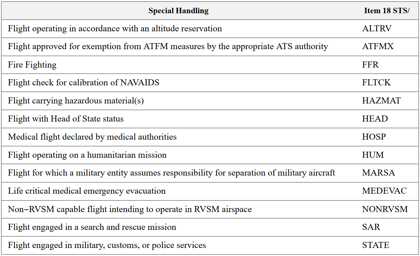
Reasons for Special Handling:
- Indicate the applicable Special Handling in Item 18 (STS/) [Figure 6]
- Any other requests for special handling must be made in Item 18 (RMK/)
- Priority for a flight is not automatically granted based on filing one of these codes but is based on documented procedures
- In some cases, additional information may also be required in remarks; follow all such instructions as well
- Include plain-language remarks when required by ATC or deemed necessary; Do not use special characters
-
Remarks:
- Include when necessary (RMK/)
-
Operator:
- When the operator is not obvious from the aircraft identification, the operator may be indicated
- For example: OPR/NETJETS
- When the operator is not obvious from the aircraft identification, the operator may be indicated
-
Flight Plan Originator:
- VFR flight plans originating outside of FAA FSS or FAA contracted flight plan filing services must enter the 8-letter AFTN address of the service where the flight plan was originally filed
- Alternately, enter the name of the service where the FPL was originally filed
- This information is critical to locating the FPL originator in the event additional information is needed
- For IFR flight plans, the original filers AFTN address may be indicated, which is helpful in cases where a flight plan has been forwarded
- For example: ORGN/Acme Flight Plans, or ORGN/KDENXLDS
- VFR flight plans originating outside of FAA FSS or FAA contracted flight plan filing services must enter the 8-letter AFTN address of the service where the flight plan was originally filed
-
Mode S Address:
- If required, enter Mode S address (not required in U.S.)
-
Selective Calling:
- Flights with HF radio and Selective Calling (SELCAL) capability should include their 4-letter SELCAL code
- For example: SEL/CLEF
- Flights with HF radio and Selective Calling (SELCAL) capability should include their 4-letter SELCAL code
-
Performance Category:
- Include the appropriate single-letter Aircraft Approach Category as defined in the Pilot/Controller Glossary
- For example: PER/A
- Include the appropriate single-letter Aircraft Approach Category as defined in the Pilot/Controller Glossary
-
Departure Aerodrome:
- A text description following the location identifier is permissible in Item 18 DEP/ when Item 13 dictates
- For example: DEP/MD21 or DEP/W29 BAY BRIDGE AIRPORT or DEP/EMI211017 or DEP/3925N07722W
- A text description following the location identifier is permissible in Item 18 DEP/ when Item 13 dictates
-
Delay Enroute:
- ICAO defines Item 18 (DLE/) to provide information about a delay en route
- International flights with a delay outside U.S. domestic airspace should indicate the place and duration of the delay in Item 18 DLE/
- The delay is expressed by a fix identifier followed by the duration in hours (H) and minutes (M), HHMM
- For example: DLE/EMI0140
- U.S. ATC systems will accept but not process information in DLE/
- Therefore, for flights in the lower 48 states, it is preferable to include the delay as part of the route (Item 15)
- Delay in this format is specified by an oblique stroke (/) followed by the letter D, followed by 2 digits for hours (H) of delay, followed by a plus sign (+), followed by 2 digits for minutes (M) of delay: /DHH+MM
- For example: DCT EMI/D01+40 DCT MAPEL/D00+30 V143 DELRO DCT
-
Alternates:
- When the airport does not have a four-letter location identifier, include ZZZZ in Item 16c and file the non-standard identifier in Item 18 ALTN/
-
Estimated Elapsed Times at Boundaries or Reporting Points:
- EETs are required for international or oceanic flights when crossing a Flight Information Region (FIR) boundary
- The EET will include the ICAO four-letter location identifier for the FIR followed by the elapsed time to the FIR boundary (e.g., KZNY0245 indicates 2 hours, 45 minutes from departure until the New York FIR boundary)
- For example: EET/MMFR0011 MMTY0039 KZAB0105
-
Remarks:
- Enter only those remarks pertinent to ATC or to the clarification of other flight plan information. Items of a personal nature are not accepted
- "DVRSN" should be placed in Item 11 only if the pilot/company is requesting priority handling to their original destination from ATC as a result of a diversion as defined in the Pilot/Controller Glossary
- Do not assume that remarks will be automatically transmitted to every controller. Specific ATC or en route requests should be made directly to the appropriate controller
-
-
Item 19 - Flight Specific Suppelemental Information:
- Item 19 data must be included when completing FAA Form 7233-4
- This information will be retained by the facility/organization that transmits the flight plan to Air Traffic Control (ATC), for Search and Rescue purposes, but it will not be transmitted to ATC as part of the flight plan
- Do not include Supplemental Information as part of Item 18. The information in Item 19 is retained with the flight plan filing service for retrieval only if necessary
- Supplemental Information within Item 19 will be transmitted as a separate message to the destination FSS for VFR flight plans filed with a FSS or FAA contracted flight plan filing service
- This will reduce the time necessary to conduct SAR actions should the flight become overdue, as this information will be readily available to the destination Flight Service Station
- Minimum required Item 19 entries for a domestic flight are Endurance, Persons on Board, Pilot Name and Contact Information, and Color of Aircraft. Additional entries may be required by foreign air traffic services, or at pilot discretion
- After E/ Enter fuel endurance time in hours and minutes
- After P/ Enter total number of persons on board using up to 30 alphanumeric characters. Enter TBN (to be notified) if the total number of persons is not known at the time of filing
- For example: P/005, P/TBN, orP/ON FILE CAPEAIR OPERATIONS
- R/ (Radio) Cross out items not carried
- S/ (Survival Equipment) Cross out items not carried
- J/ (Jackets) Cross out items not carried
- D/ (Life Raft/Dinghies) Enter number carried and total capacity. Indicate if covered and color
- A/ (Aircraft Color and Markings) Enter aircraft color(s)
- N/ (Remarks. Not for ATC) select N if no remarks
- Enter comments concerning survival equipment and information concerning personal GPS locating service, if utilized
- Enter name and contact information for responsible party to verify VFR arrival/closure, if desired
- Ensure party will be available for contact at ETA (for example; FBO is open at ETA)
- C/ (Pilot) Enter name and contact information, including telephone number, of pilot-in-command
- Ensure contact information will be valid at ETA in case SAR is necessary

How to Complete a 7233-1 Flight Plan
- Within U.S. controlled air space, FAA Form 7233-1, Flight Plan, may be used by filers of DOD/military flight plans and civilian stereo route flight plans
-
Block 1 - Type of Flight Plan:
Check the type of flight plan (VFR/IFR) -
Block 2 - Aircraft Identification:
Enter your complete aircraft identification, including the prefix "N," if applicable -
Block 3 - Aircraft Type/Special Equipment:
Enter the designator for the aircraft, followed by a slant (/), and the transponder or DME equipment code letter; e.g., C-182/U [Figure 1/2 ]-
Aircraft Prefixes:
- When filing, include as a prefix to the aircraft type, the number of aircraft when more than one, and/or heavy aircraft indicator "H/" if appropriate
- 2/F18/A
- H/DC10/A
- When filing, include as a prefix to the aircraft type, the number of aircraft when more than one, and/or heavy aircraft indicator "H/" if appropriate
-
Aircraft Suffixes:
- When filing, identify the equipment capability to ATC by adding a suffix, preceded by a slant, to the AIRCRAFT TYPE [Figure 1]
- ATC issues clearances to IFR aircraft based on filed suffixes which requires pilots to determine the appropriate suffix based upon desired services and/or routing
- Example: if a desired route/procedure requires GPS, a pilot should file /G even if the aircraft also qualifies for other suffixes
- For procedures requiring GPS, if the navigation system does not automatically alert the flight crew of a loss of GPS, the operator must develop procedures to verify correct GPS operation
- The suffix is not to be added to the aircraft identification or be transmitted by radio as part of the aircraft identification
- It is recommended that pilots file the maximum transponder or navigation capability of their aircraft in the equipment suffix in order to provide ATC with the necessary information to utilize all facets of navigational equipment and transponder capabilities available
- ATC issues clearances to IFR aircraft based on filed suffixes which requires pilots to determine the appropriate suffix based upon desired services and/or routing
-
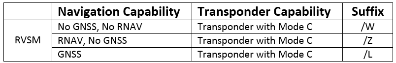
RVSM Aircraft Suffixes -
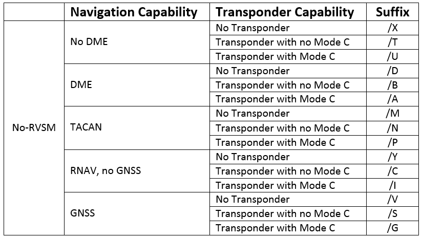
No-RVSM Aircraft Suffixes
- When filing, identify the equipment capability to ATC by adding a suffix, preceded by a slant, to the AIRCRAFT TYPE [Figure 1]
- ATC radar history data can be useful in finding a downed or missing aircraft; therefore, surveillance equipment should be listed in Item 18
- Pilots using commercial GPS tracking services are encouraged to note the specific service in Item 19 N/ (survival equip remarks) of FAA Form 7233-4 or DD Form 1801
-
-
Block 4 - True Airspeed:
Enter the true airspeed (TAS)- If the average TAS changes plus or minus 5% or 10 knots, whichever is greater, remember to report so to ATC
-
Block 5 - Departure Point:
Enter the departure airport identifier code (or the airport name, city and state, if the identifier is unknown)- Use of identifier codes will expedite the processing of your flight plan
- Include the city name (or even the state name), if needed for clarity
-
Block 6 - Departure Time:
Enter the proposed departure time in Coordinated Universal Time (UTC) (Z)- If airborne, specify the actual or proposed departure time as appropriate
-
Block 7 - Cruising Altitude:
Enter the appropriate en route altitude or flight level to assist the FSS briefer in providing weather and wind information (FAR 91.159)-
VFR Cruising Altitudes:
- When flying VFR or VFR-on-top:
- Magnetic course of 0-179° any odd thousand +500 feet MSL or;
- Magnetic course of 180-359° any even thousand +500 feet MSL
- When flying VFR or VFR-on-top:
-
IFR Cruising Altitudes:
- Except while in a holding pattern of 2 minutes or less, or while turning, each person operating IFR, uncontrolled through RVSM altitudes:
- Magnetic course of 0-179° any odd thousand feet MSL or;
- Magnetic course of 180-359° any even thousand feet MSL
- Except while in a holding pattern of 2 minutes or less, or while turning, each person operating IFR, uncontrolled through RVSM altitudes:
- Enter only the initial requested altitude in this block
- When more than one altitude or flight level is desired along the route of flight, it is best to make a subsequent request direct to the controller
-
-
Block 8 - Route of Flight:
Define the route of flight by using NAVAID identifier codes (or names if the code is unknown), airways, jet routes, and waypoints (for RNAV)- Use NAVAIDs or waypoints to define direct routes and radials/bearings to define other unpublished routes
-
Block 9 - Destination:
Enter the destination airport identifier code (or the airport name, city and state, if the identifier is unknown)- Include the city name (or even the state name) if needed for clarity
-
Block 10 - Estimated Time Enroute:
Enter your estimated time en-route in hours and minutes, based on latest forecast winds -
Block 11 - Remarks:
Enter only those remarks pertinent to the clarification of other flight plan information, such as the Radiotelephony (call sign) associated with a designator filed in Block 2, if the Radiotelephony is new, has changed within the last 60 days, or is a special FAA-assigned temporary Radiotelephony- For VFR Flight plans, include information that may aid in VFR search and rescue, such as planned stops en route or student cross country, or remarks
- Items of a personal nature are not accepted
- In cases where there is no three-letter designator but only an assigned Radiotelephony or an assigned three-letter designator is used in a medical emergency, the Radiotelephony must be included in the remarks field
- The pilot is responsible for knowing when it is appropriate to file the Radiotelephony in remarks under the 60-day rule or when using FAA special Radiotelephony assignments
- "DVRSN" should be placed in Block 11 only if the pilot/company is requesting priority handling to their original destination from ATC as a result of a diversion as defined in the Pilot/Controller Glossary
- Do not assume that remarks will be automatically transmitted to every controller. Specific ATC or en route requests should be made directly to the appropriate controller
- Pilots should include the acronym "TEC" in the remarks section of the flight plan when requesting tower en route control
-
Block 12 - Fuel on Board:
Specify the fuel on board computed from the departure point in hours and minutes- VFR: FAR 91.167 states, for IFR operations, you must have enough fuel to fly to your first point of intended landing and fly thereon to the alternate and fly after that for 45 minutes at normal cruising speed, 30 for helicopters
- IFR: FAR 91.151 states you must have enough fuel to fly to your first point of intended landing and assuming normal cruising speed 30 minutes beyond (day) or 45 minutes beyond (night) or 20 minutes (rotor-craft)
-
Block 13 - Alternate Airport:
Specify an alternate airport if desired/required (see below), but do not include routing -
Block 14 - Contact Information:
Enter the complete name, address, and telephone number of the pilot-in-command, or in the case of a formation flight, the formation commander- Enter sufficient information to identify home base airport or operator
- If you do not want to give your personal information you may write "on file with..." and name your flight school
- This information is essential in the event of search and rescue operation
-
Block 15 - Persons Aboard:
Enter total number of Persons on Board (POB), including crew -
Block 16 - Aircraft Color:
Enter the predominant colors -
Block 17 - Destination Contact:
Record the destination contact
Alternate Airport Requirements
- Alternate airports are back-up airports that are selected ahead of a flight in the event a landing cannot be made at your destination
- There are several reasons an alternate may need to be utilized, including several reasons you cannot control such as weather, or an airport closure
-
Visual Flight Rules:
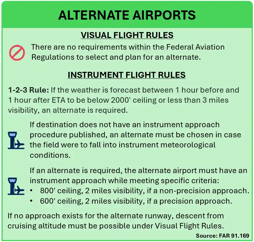
- There are no requirements in the Federal Aviation Regulations to select and plan for an alternate. [Figure 3]
- The lack of a requirement does not preclude pilots from being prepared.
-
Instrument Flight Rules:
- FAR 91.169 outlines a 1-2-3 rule: [Figure 3]
- If the weather is forecast between 1 hour before and 1 hour after ETA to be below 2000' ceiling or less than 3 miles visibility, an alternate is required.
- In addition to the 1-2-3 rule, if your destination does not have an instrument approach procedure published, an alternate must be chosen in case the field were to fall into instrument meteorological conditions.
- If an alternate is required, the alternate airport must have an instrument approach while meeting specific criteria:
- 800' ceiling, 2 miles visibility, if a non-precision approach.
- 600' ceiling, 2 miles visibility, if a precision approach.
- If no approach exists for the alternate runway, descent from cruising altitude must be possible under Visual Flight Rules.
- FAR 91.169 outlines a 1-2-3 rule: [Figure 3]
- All rules apply to the runway in use
- GPS approaches may be planned for at the primary airport, or the alternate, but not both
- If an A is in the header section of the approach plate other minimums apply, an A-NA means it cannot be used as an alternate
- For RNAV specifics, see alternate airport considerations
-
Alternate Planning:
- Although alternates may be planned for by a VFR or IFR pilot, the term and regulations only apply to the IFR pilot
If an Alternate is Required:
- Route: fly to destination IAF and then to alternate IAF at filed cruising altitude
- Fuel: for one approach, start, taxi, and takeoff
- Fuel Reserve: 10% of planned requirements or 20 minutes of flight computed at 10,000' MSL maximum endurance operation (whichever is greater)
-
If an Alternate is Not Required:
- Route: fly to destination IAF, plus fuel for one approach
- Fuel Reserve: 10% of planned requirements or 20 minutes of flight computed at 10,000' MSL maximum endurance operation (whichever is greater)
- When considering an alternate, consider filing one for any high altitude operations where weather can deteriorate quickly and minimums are not as low as other low altitude airports
- When computing fuel reserves, include any known or expected delay in your "time en-route"
- If the route or altitude assigned by ATC renders the planned fuel reserves inadequate, you must inform ATC of the circumstances and if you're unable to obtain a satisfactory altitude or routing, alter the destination accordingly
- Despite VFR pilots being exempt, it is always recommended to plan for an alternate in case of unplanned weather, airport closure, or if fuel becomes unavailable
- Although alternates may be planned for by a VFR or IFR pilot, the term and regulations only apply to the IFR pilot
Change in Proposed Departure Time
- To prevent computer saturation in the en route environment, parameters have been established to delete proposed departure flight plans which have not been activated
- Most centers have this parameter set so as to delete these flight plans a minimum of 2 hours after the proposed departure time or Expect Departure Clearance Time (EDCT)
- To ensure that a flight plan remains active, pilots whose actual departure time will be delayed 2 hours or more beyond their filed departure time, are requested to notify ATC of their new proposed departure time
- Due to traffic saturation, ATC personnel frequently will be unable to accept these revisions via radio. It is recommended that you forward these revisions to a flight plan service provider or FSS
Change in Flight Plan
- If subsequent planning after filing reveals a change that means the threshold for in-flight reporting requirements then flight plans should be made to reflect
- All changes to existing flight plans should be completed more than 46 minutes prior to the proposed departure time
- Changes must be made with the initial flight plan service provider
- If the initial flight plan's service provider is unavailable, filers may contact an ATC facility or FSS to make the necessary revisions
- Any revision 46 minutes or less from the proposed departure time must be coordinated through an ATC facility or FSS
Canceling/Closing A Flight Plan
-
Canceling/Closing an IFR Flight Plan:
- IFR flight plans may be canceled at any time, but the procedures will differ if mid-flight or post-flight.
- There are further considerations when operating to a towered or non-towered airport.
-
Canceling an IFR Flight Plan Mid-Flight:
- An IFR flight plan may be canceled at any time the flight is operating in VFR conditions outside Class A airspace by pilots stating "[Callsign] is canceling my IFR flight plan" to the controller or air/ground station with which they are communicating.
- Immediately after canceling an IFR flight plan, a pilot should take the necessary action to change to the appropriate air/ground frequency, VFR radar beacon code and VFR altitude or flight level.
- ATC separation and information services will be discontinued, including radar services (where applicable) unless VFR radar advisory service (flight following) has been requested, and approved by ATC
- Pilots must be aware that other procedures may be applicable to a flight that cancels an IFR flight plan within an area where a special program, such as a designated Terminal Radar Service Area (TRSA), Class C airspace, or Class B airspace, has been established.
- An IFR flight plan may be canceled at any time the flight is operating in VFR conditions outside Class A airspace by pilots stating "[Callsign] is canceling my IFR flight plan" to the controller or air/ground station with which they are communicating.
-
Canceling/Closing an IFR Flight Plan Post-Flight:
- If complete with the flight plan, closing the flight plan will depend upon if operating at a towered or non-towered airport.
-
Towered Airports:
- If operating on an IFR flight plan to an airport with a functioning control tower, the flight plan is automatically closed upon landing
- It is a good idea to confirm if tower does not explicitly state.
- "[Agency], confirm IFR flight plan now closed for [[Callsign]]."
- If operating on an IFR flight plan to an airport with a functioning control tower, the flight plan is automatically closed upon landing
-
Non-Towered Airports:
- If operating on an IFR flight plan to an airport where there is no functioning control tower, the pilot must initiate cancellation of the IFR flight plan.
- Cancelling can be done via radio after landing if there is a functioning FSS or other means of direct communications with ATC.
- In the event there is no FSS and/or air/ground communications with ATC is not possible below a certain altitude, it is preferred, weather conditions permitting, that the pilot cancel the IFR flight plan while still airborne and able to communicate with ATC by radio.
- Cancelling airborne not only saves a phone call but will quickly release the airspace for use by other aircraft
- If all else fails, canceling the flight plan may be done via phone through FSS.
- If a DVFR flight plan requirement exists, the pilot is responsible for filing this flight plan to replace the canceled IFR flight plan
- If a subsequent IFR operation becomes necessary, a new IFR flight plan must be filed and an ATC clearance obtained before operating in IFR conditions
- See 14 CFR Section 91.153 and 14 CFR Section 91.169 for more
IFR Operations to High Altitude Destinations
- Pilots planning IFR flights to airports located in mountainous terrain are cautioned to consider the necessity for an alternate airport even when the forecast weather conditions would technically relieve them from the requirement to file one
- See 14 CFR Section 91.167, and AIM, Paragraph 4-1-19, Tower En Route Control (TEC) for more
- The FAA has identified three possible situations where the failure to plan for an alternate airport when flying IFR to such a destination airport could result in a critical situation if the weather is less than forecast and sufficient fuel is not available to proceed to a suitable airport
- An IFR flight to an airport where the Minimum Descent Altitudes (MDAs) or landing visibility minimums for all instrument approaches are higher than the forecast weather minimums specified in 14 CFR Section 91.167(b). For example, there are 3 high altitude airports in the U.S. with approved instrument approach procedures where all of the MDAs are greater than 2,000 feet and/or the landing visibility minimums are greater than 3 miles (Bishop, California; South Lake Tahoe, California; and Aspen-Pitkin Co./Sardy Field, Colorado). In the case of these airports, it is possible for a pilot to elect, on the basis of forecasts, not to carry sufficient fuel to get to an alternate when the ceiling and/or visibility is actually lower than that necessary to complete the approach
- A small number of other airports in mountainous terrain have MDAs which are slightly (100 to 300 feet) below 2,000 feet AGL. In situations where there is an option as to whether to plan for an alternate, pilots should bear in mind that just a slight worsening of the weather conditions from those forecast could place the airport below the published IFR landing minimums
- An IFR flight to an airport which requires special equipment; i.e., DME, glide slope, etc., in order to make the available approaches to the lowest minimums. Pilots should be aware that all other minimums on the approach charts may require weather conditions better than those specified in 14 CFR Section 91.167(b). An inflight equipment malfunction could result in the inability to comply with the published approach procedures or, again, in the position of having the airport below the published IFR landing minimums for all remaining instrument approach alternatives
Civil Aircraft Operations Transiting U.S. Territorial Airspace
- Civil aircraft (except those operating in accordance with subparagraphs 5-6-7b, 5-6-7c, 5-6-7d, and 5-6-7e) are authorized to transit U.S. territorial airspace if in compliance with all of the following conditions:
- File and are on an active flight plan (IFR, VFR, or DVFR);
- Equipped with an operational transponder with altitude reporting capability and continuously squawk an ATC assigned transponder code;
- Equipped with an operational ADS-B Out when operating in airspace specified in 14 CFR 91.225;
- Maintain two-way radio communications with ATC;
- Comply with all other applicable ADIZ requirements described in paragraph 5-6-4 and any other national security requirements in paragraph 5-6-2;
- Are operating under an approved TSA aviation security program (see paragraph 5-6-10 for TSA aviation security program information) or are operating with and in accordance with an FAA/TSA airspace waiver (see paragraph 5-6-9 for FAA/TSA airspace waiver information), if:
- The aircraft is not registered in the U.S.; or
- The aircraft is registered in the U.S. and its maximum takeoff gross weight is greater than 100,309 pounds (45,500 kgs);
- Are in receipt of, and are operating in accordance with, an FAA routing authorization if the aircraft is registered in a U.S. State Department-designated special interest country or is operating with the ICAO 3LD of a company in a country listed as a U.S. State Department-designated special interest country, unless the operator holds valid FAA Part 129 operations specifications. VFR and DVFR flight operations are prohibited for any aircraft requiring an FAA routing authorization. (See paragraph 5-6-11 for FAA routing authorization information.)
- Civil aircraft registered in Canada or Mexico, and engaged in operations for the purposes of air ambulance, firefighting, law enforcement, search and rescue, or emergency evacuation are authorized to transit U.S. territorial airspace within 50 NM of their respective borders with the U.S., with or without an active flight plan, provided they have received and continuously transmit an ATC-assigned transponder code
- Civil aircraft registered in Canada, Mexico, Bahamas, Bermuda, Cayman Islands, or the British Virgin Islands with a maximum certificated takeoff gross weight of 100,309 pounds (45,500 kgs) or less are authorized to transit U.S. territorial airspace if in compliance with all of the following conditions:
- File and are on an active flight plan (IFR, VFR, or DVFR) that enters U.S. territorial airspace directly from any of the countries listed in this subparagraph 5-6-7c. Flights that include a stop in a non-listed country prior to entering U.S. territorial airspace must comply with the requirements prescribed by subparagraph 5-6-7a above, including operating under an approved TSA aviation security program (see paragraph 5-6-10 for TSA aviation program information) or operating with, and in accordance with, an FAA/TSA airspace waiver (see paragraph 5-6-9 for FAA/TSA airspace waiver information)
- Equipped with an operational transponder with altitude reporting capability and continuously squawk an ATC assigned transponder code; and
- Equipped with an operational ADS-B Out when operating in airspace specified in 14 CFR 91.225;
- Maintain two-way radio communications with ATC
- Comply with all other applicable ADIZ requirements described in paragraph 5-6-4 and any other national security requirements in paragraph 5-6-2
- Civil aircraft registered in Canada, Mexico, Bahamas, Bermuda, Cayman Islands, or the British Virgin Islands with a maximum certificated takeoff gross weight greater than 100,309 pounds (45,500 kgs) must comply with the requirements subparagraph 5-6-7a, including operating under an approved TSA aviation security program (see paragraph 5-6-10 for TSA aviation program information) or operating with, and in accordance with, an FAA/TSA airspace waiver (see paragraph 5-6-9 for FAA/TSA airspace waiver information)
- Civil aircraft registered in the U.S., Canada, or Mexico with a maximum certificated takeoff gross weight of 100,309 pounds (45,500 kgs) or less that are operating without an operational transponder and/or the ability to maintain two-way radio communications with ATC, are authorized to transit U.S. territorial airspace over Alaska if in compliance with all of the following conditions:
- Enter and exit U.S. territorial airspace over Alaska north of the fifty-fourth parallel;
- File and are on an active flight plan;
- Squawk 1200 if VFR and equipped with a transponder
- Comply with all other applicable ADIZ requirements described in paragraph 5-6-4 and any other national security requirements in paragraph 5-6-2
VFR & IFR Flight Plans Conclusion
- VFR flights do not normally require a flight plan unless (except for DOD and law enforcement flights) into an ADIZ, and hence international flights, are required to file DVFR flight plans
- Although not always required, it is strongly recommended that a flight plan (for a VFR flight) be filed with an FAA FSS to secure VFR Search and Rescue Protection
- It is recommended to file flight plans with FSS, that, for your convenience, provide aeronautical and meteorological briefings while accepting flight plans
- When a stopover flight is anticipated, it is recommended that a separate flight plan be filed for each leg of the flight
- When a composite flight plan is anticipated, requiring two separate flight plans to be filed under each flight rule, the IFR plan will be routed to ATC, and the VFR plan will be routed to a Flight Service for Search and Rescue services
- Flight plans may be submitted to the nearest Flight Service Station (FSS) or Air Traffic Control Tower (ATCT) either in person, by telephone, or by radio, if no other means are available
- There are several methods of obtaining IFR clearances at non-tower, non-FSS, and outlying airports. The procedure may vary due to geographical features, weather conditions, and the complexity of the ATC system. To determine the most effective means of receiving an IFR clearance, pilots should ask the nearest FSS the most appropriate means of obtaining the IFR clearance
- For more information see www.1800wxbrief.com
- Consult an FSS briefer for any unknown elements
- International flights, including those that temporarily leave domestic U.S. airspace and return, require all applicable information in the international flight plan
- It is, therefore, recommended that operators planning flights outside U.S. domestic airspace become familiar with applicable international documents, including ICAO Doc. 4444 (Procedures for Air Navigation Services, Air Traffic Management), and ICAO Doc. 7030 (Regional Supplemental Procedures) as well as the Aeronautical Information Publications (AIPs), Aeronautical Information Circulars (AICs), and NOTAMs of applicable other countries
- Additional information to assist with filing a flight plan using the international format can be found at https://www.faa.gov/ato?k=fpl
- Standards for nationality, common and registration marks to be used are contained in Annex 7, Chapter 2
- Provisions for using radiotelephony call signs are contained in Annex 10, Volume II, Chapter 5. ICAO designators and telephony designators for aircraft operating agencies are contained in Doc 8585-Designators for Aircraft Operating Agencies, Aeronautical Authorities and Services
- Still looking for something? Continue searching:
VFR & IFR Flight Plans References
- AOPA - File A Flight Plan
- Federal Aviation Administration - Pilot/Controller Glossary
- Aeronautical Information Manual (5-1-5) Flight Plan - VFR Flights
- Aeronautical Information Manual (5-1-6) Flight Plan - IFR Flights
- Aeronautical Information Manual (5-1-7) Flight Plans For Military/DOD Use Only
- Aeronautical Information Manual (5-1-8) Flight Plans - Defense VFR (DVFR) Flights
- Aeronautical Information Manual (5-1-9) Single Flights Conducted with Both VFR And IFR Flight Plans
- Aeronautical Information Manual (5-1-10) IFR Operations to High Altitude Destinations
- Aeronautical Information Manual (5-1-12) Change in Flight Plan
- Aeronautical Information Manual (5-1-13) Change in Proposed Departure Time
- Aeronautical Information Manual (5-1-14) Closing VFR/DVFR Flight Plans
- Aeronautical Information Manual (5-1-15) Canceling IFR Flight Plan
- Aeronautical Information Manual (5-1-16) RNAV and RNP Operations
- Aeronautical Information Manual (5-2-9) Instrument Departure Procedures (DP) - Obstacle Departure Procedures (ODP) and Standard Instrument Departures (SID)
- Aeronautical Information Manual (5-4-1) Standard Terminal Arrival (STAR), Area Navigation (RNAV) STAR, and Flight Management System Procedures (FMSP) for Arrivals
- Aeronautical Information Manual (5-6-1) National Security
- Aeronautical Information Manual (6-2-7) Search and Rescue
- FAA Form 7233-1
- Federal Aviation Regulations (91.153) VFR flight plan: information required
- Federal Aviation Regulations (91.167) Fuel requirements for flight in IFR conditions
- Federal Aviation Regulations (91.169) IFR flight plan: Information required
- Federal Aviation Regulations (91.173) ATC clearance and flight plan required
- Federal Aviation Regulations (91.179) IFR cruising altitude or flight level
- Federal Aviation Regulations (91.181) Course to be flown
- Instrument Flying Handbook
- FAA - ICAO FPL Quick Guide (2019)