Class Alpha Airspace
Class Alpha Airspace is a non-charted, positive control airspace and the beginning of the flight levels in the United States.
Class Alpha Airspace Introduction
- Class Alpha (also called "Class A") Airspace is positive control airspace, meaning Air Traffic Control (ATC) can see and track aircraft.
- Radar services are provided to aircraft operating under Instrument Flight Rules (IFR).
- Class alpha airspace encompasses the high-altitude enroute environment, containing "cruise altitudes" or "Flight Levels" (FL) in the United States.
- Given its expansive dimensions, navigation charts omit depictions.
- Operations in Class Alpha airspace require adherence to relevant operating rules & pilot equipment requirements.
- ATC may grant authorizations to deviate from operating and equipment requirements when the situation permits.
- When you have a solid understanding of Class Alpha Airspace, compare your knowledge against the Private Pilot (Airplane) or Commercial Pilot (Airplane) Airman Certification Standards.
Class Alpha Airspace Air Traffic Services
- Pilots operating in Class Alpha are operating on an instrument flight clearance and therefore provided services in accordance.
- When pilots are operating VFR on top, the pilot is responsible to fly at an appropriate VFR altitude, comply with VFR visibility and distance from cloud criteria, and to be vigilant so as to see and avoid other aircraft
- The pilot is also responsible to comply with instrument flight rules applicable to the flight (e.g., adherence to ATC clearances).
- Although IFR separation is not applied, controllers must continue to provide traffic advisories and safety alerts, and apply merging target procedures to aircraft operating VFR‐on‐top.
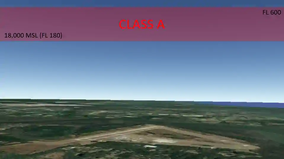
Class Alpha Airspace Dimensions
- Vertically, Class Alpha begins at 18,000' Mean Sea Level (MSL) up to and including FL600 (about 60,000' MSL).
- Horizontally, Class Alpha begins when within 12 Nautical Miles (NM) of the coast in 48 contiguous states and Alaska and designated international airspace beyond 12 NM off the coast of the 48 contiguous States and Alaska within areas of domestic radio navigational signal or ATC radar coverage, and within which domestic procedures apply.
- Examples include Santa Barbara Island, Farallon Islands, and airspace south of latitude 25°04'00" North.
- Class Alpha airspace does not include the airspace less than 1,500 feet above the earth's surface and the Alaska Peninsula west of longitude 160°00'00" West.
Class Alpha Airspace Depiction
- Navigation charts omit Class A airspace depictions.

Class Alpha Airspace Operating Rules & Pilot/Equipment Requirements
-
Pilot Qualifications:
-
VFR Visibility Requirements:
- Unless otherwise authorized, each person operating an aircraft in Class A airspace must conduct operations under Instrument Flight Rules (IFR).
- See 14 Code of Federal Regulations (FAR) Section 71.33, Sections 91.167 through 91.193, Sections 91.215 through 91.217, and Sections 91.225 through 91.227.
- Unless otherwise authorized, each person operating an aircraft in Class A airspace must conduct operations under Instrument Flight Rules (IFR).
-
Entry Requirements:
- IFR Clearance.
- IFR flight plan.
- IFR-equipped aircraft.
- Two-way radio communications.
- Unless otherwise authorized by ATC, a 91.215.
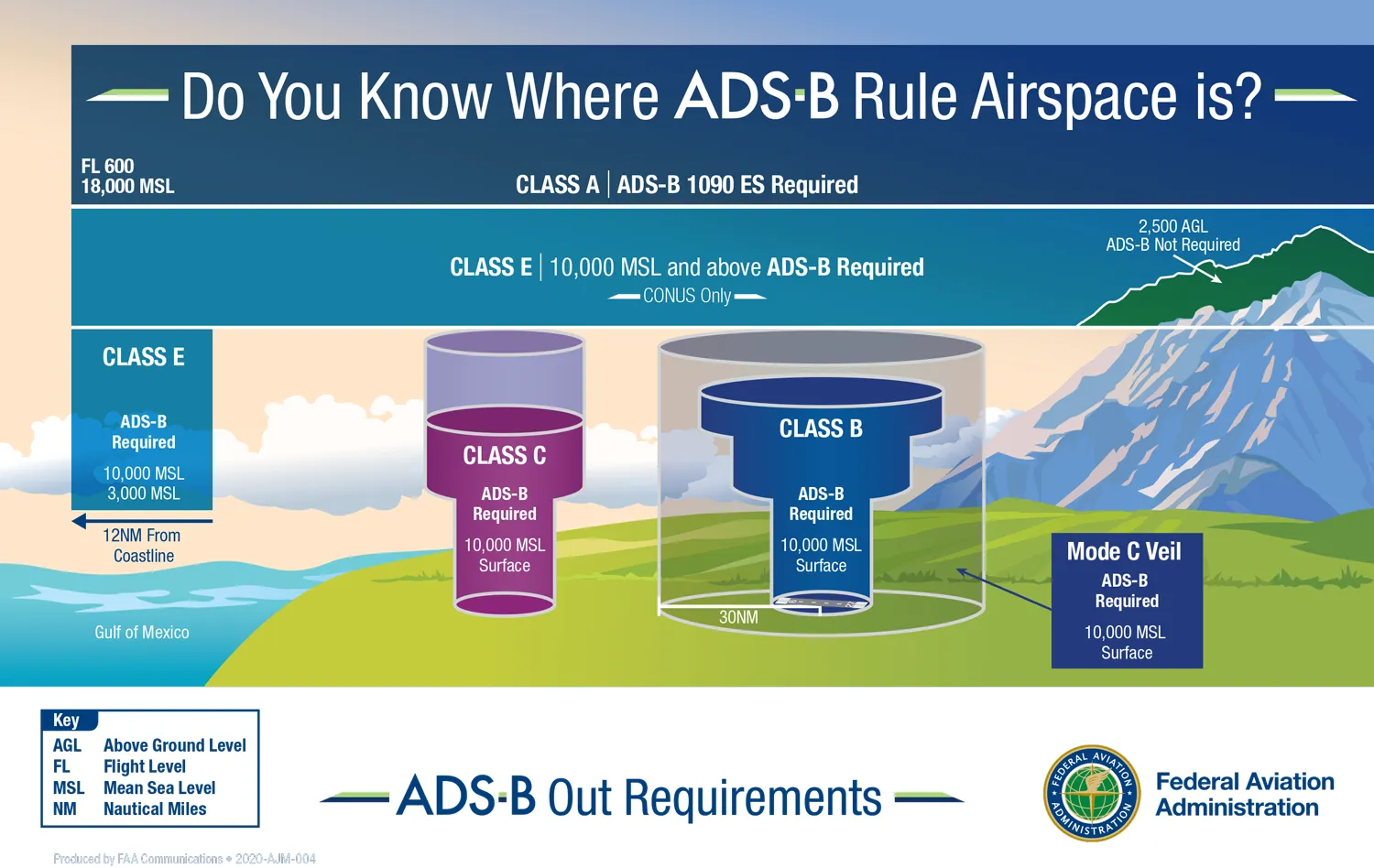
- After January 1, 2020, the applicable Automatic Dependent Surveillance-Broadcast (ADS-B) Out equipment specified in 91.225.
- If navigating above 24,000', aircraft require VHF Omni-Directional Range (VOR) and Distance Measuring Equipment (DME).
-
Equipment Requirements:
-
Transponder:
- Unless otherwise authorized by ATC, an operable radar beacon transponder with automatic altitude reporting capability and operable ADS-B Out equipment. [Figure 3]
-
Communication Equipment:
- Two-way radio communications with the controlling agency (described below) are required.
-
-
ATC Clearances & Separation
-
ATC Facility:
- Air Route Traffic Control Center (ARTCC).
- Also known as "center."
- Example: "Atlanta center."
- Pilots require an ATC clearance before entering Class Alpha airspace.
- Air Route Traffic Control Center (ARTCC).
- Separation standards are applied and provided for all aircraft.
- Pilots must change their altimeter setting from the local altimeter to 29.92 when climbing through 18,000 feet.
- Setting 29.92 ensures all aircraft flying in Class A airspace have the same altimeter setting and will have proper altitude separation.
- Non-Reduced Vertical Separation Minima (RVSM) separation is 2,000' vertically.
- RVSM separation is 1,000' vertically.
-
-
Jet & Q Route Systems:
-
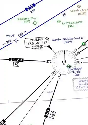
Jet Route System:
- Similar to the Victor route system, the jet route system consists of jet routes established from 18,000' MSL to FL 450 inclusive
- These routes are depicted on Enroute High Altitude Charts
- Depicted in black on aeronautical charts
- Identified by a "J" (Jet) followed by the airway number (e.g., J12)
- Jet routes, as VOR airways, are predicated solely on VOR or VORTAC navigation facilities (except in Alaska)
- Segments of jet routes in Alaska are based on L/MF navigation aids and are charted in brown color instead of black on en route charts
- Operation above FL 450 may be conducted on a point-to-point basis.
- Navigational guidance is provided on an area basis utilizing those facilities depicted on the enroute high altitude charts
- With respect to position reporting, reporting points are designated for jet route systems. Flights using jet routes will report over these points unless otherwise advised by ATC
- Note the range of Jet Routes may be limited due to Standard Service Volume (SSV) of ground stations. [Figure 4]
- Jet routes have no defined width.
- A Navigational Aid (NAVAID) on a continuing jet route is NOT part of the segment and should not be included in your flight plan.
- Similar to the Victor route system, the jet route system consists of jet routes established from 18,000' MSL to FL 450 inclusive
-
Q Route System:
- Q-Routes are available for use by RNAV-equipped aircraft between 18,000' MSL and FL450 (about 45,000'), the same as J Routes.
- Enroute High Altitude Charts depict Q Routes. [Figure 4]
- Operations above FL450 (about 45,000') are permitted point-to-point.
- RNAV routes are established in low-altitude and high-altitude structures, depicted on the enroute low and high chart series.
- High-altitude RNAV routes are identified with a "Q" prefix (except the Q-routes in the Gulf of Mexico), and low-altitude RNAV routes are identified with a "T" prefix.
- RNAV routes and data are depicted in aeronautical blue.
- In addition to the published routes, pilots may fly random RNAV routes under IFR if ATC approves.
- Random RNAV routes are direct routes, based on RNAV capability, between waypoints defined in terms of latitude/longitude coordinates, degree-distance fixes, or offsets from established routes/airways at a specified distance and direction.
- ATC is required to radar monitor random RNAV routes.
- Approval for these routes requires a radar environment.
- ATC considers factors in approving random RNAV routes, including the capability to provide radar monitoring and compatibility with traffic volume and flow.
- ATC will radar monitor each flight; however, pilots are responsible for navigating the random RNAV route.
-
Class Alpha Airspace Conclusion
- Federal Aviation Regulation 91.155 governs VFR ceiling and visibility minimums.
- ATC assigns altitudes based on pressure altitude (synonymous with Flight Level), which means pilots shall set altimeters to the standard of 29.92 inHg.
- The use of the standard 29.92 has several implications you must understand.
- The only airspace not depicted on sectional charts is Class Alpha airspace.
- There is no Class A airspace over Hawaii, and Victor Airways has no upper limit in Hawaii.
- To learn more about flight planning and navigation tools, check out:
- Reduced Vertical Separation Minimum (RVSM) begins at FL290 and extends to FL410.
- Still looking for something? Continue searching:
Class Alpha Airspace References
- Aeronautical Information Manual (3-2-2) Class A Airspace
- Aeronautical Information Manual (5-3-4) Airways and Route Systems
- AeroNav Products - Aeronautical Chart User's Guide
- AOPA - Know Before You Go: Navigating Today's Airspace
- Federal Aviation Administration Order (7400.9) Airspace Designations and Reporting Points
- Federal Aviation Administration (91.135) Operations in Class A airspace
- Federal Aviation Regulations (91.215) ATC transponder and altitude reporting equipment and use
- Federal Aviation Regulations (91.225) Automatic Dependent Surveillance-Broadcast (ADS-B) Out equipment and use
- Federal Aviation Administration - Pilot/Controller Glossary
- Federal Aviation Regulations (Part 71 subpart A) Class A Airspace
- Instrument Flying Handbook (1-2) Airspace Classification
- Sky Vector