Special Use Airspace
The Federal Aviation Administration designates areas within the National Airspace System where specific activities or hazards exist as special use airspace.
Introduction to Special Use Airspace
- Special Use Airspace is a term used to define a group of Airspace types.
- In those instances where security requirements dictate, the Federal Aviation Administration establishes prohibited airspace to completely segregate surface areas from flight operations.
- Like prohibited airspace, restricted airspace limits most flight operations but permits some when the controlling agency approves.
- Airspace, not solely under the jurisdiction of the U.S., that may pose hazards to non-participating aircraft are called Warning Areas, alerting pilots to exercise caution.
- National Security Areas establish protected airspace that provides security for those locations that are most vital to national security.
- Throughout the U.S., the Federal Aviation Administration establishes Military Operating Areas to identify airspace that contains dynamic military operations.
- Areas with uniquely high levels of air traffic are designated as Alert Areas, which provide pilots with advanced warning.
- Controlled Firing Areas are uncharted but monitored airspace areas with episodic aerial hazards that could otherwise threaten flight operations.
- When you have a solid understanding of Special Use Airspace, compare your knowledge against the Private Pilot (Airplane) or Commercial Pilot (Airplane) Airman Certification Standards.
- Think you've got a solid understanding of special use airspace? Don't miss the special use airspace quiz below, and the topic summary.
Special Use Airspace Key Highlights
- Special use airspace consists of designated airspace areas where activities must be confined because of their nature or where limitations are imposed on aircraft operations.
- Special use airspace categories include prohibited areas, restricted areas, warning areas, military operations areas, alert areas, and controlled firing areas.
- Prohibited areas contain sensitive national security locations where aircraft operations are forbidden.
- Restricted areas contain hazardous activities such as artillery firing, missile operations, or military training exercises.
- Military operations areas (MOAs) separate military training activities from IFR traffic and require increased pilot vigilance.
- Warning areas extend over domestic or international waters and warn pilots of potentially hazardous military activities.
- Alert areas notify pilots of unusual or high volumes of aerial activity such as flight training or parachute operations.
- Controlled firing areas suspend hazardous activities when aircraft are detected approaching the area.
- Pilots should review charts, NOTAMs, and ATC advisories carefully before operating near special use airspace.
- Understanding special use airspace improves situational awareness, regulatory compliance, and overall flight safety.
Prohibited Airspace
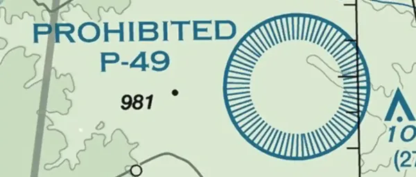
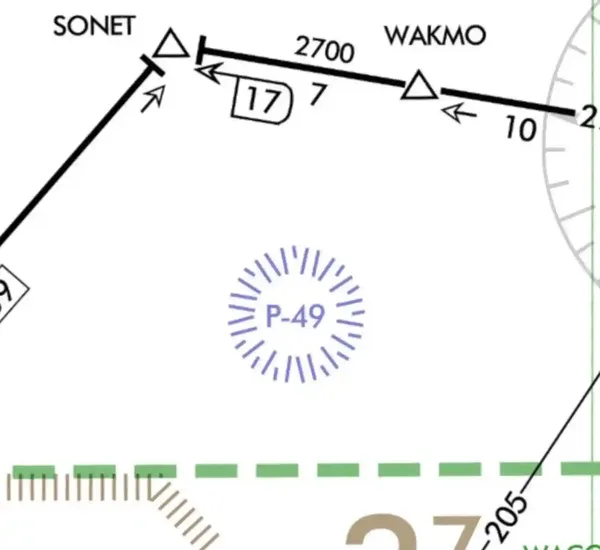
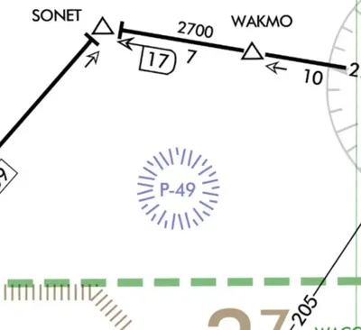
- Prohibited airspace designates an area that prohibits the flight of aircraft.
- No person may operate an aircraft within a prohibited area unless the using agency has granted authorization.
- Such areas are established for security and other national welfare reasons and should be considered off-limits.
- Prohibited airspace areas are regulatory, established through the rule-making, reflected in 14 CFR Part 73 Subpart C, and published in the Federal Register.
- Violating prohibited airspace without a clearance is grounds for interception and follow-on legal action.
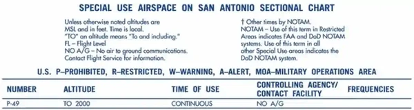
- FAA JO 7400.10, Special Use Airspace, provides a complete list of prohibited airspace areas, altitudes, times of designation, and the using agency.
-
Prohibited Airspace Depiction:
- Prohibited airspace areas are depicted on aeronautical charts, including VFR sectionals and IFR en-route low-altitude charts.
- The FAA charts prohibited areas with a "P-" followed by a designation number, and are positioned either within or immediately adjacent to the area. [/]
- Details about specific prohibited areas are available on the side of the corresponding sectional chart. []


Restricted Airspace
- Restricted airspace is an area within which the flight of aircraft is not wholly prohibited but is subject to restrictions.
- Restricted Areas are subject to restriction as they contain unusual, often invisible hazards to aircraft, such as artillery firing, aerial gunnery, or flight of guided missiles.
- Penetration of restricted areas without authorization from the using or controlling agency may be extremely hazardous to the aircraft and its occupants.
- Restricted areas limit activities to avoid non-participating traffic from interfering with other operations within the area.
- No person may operate an aircraft within restricted Airspace unless abiding by the restrictions imposed.
- ATC facilities apply the following procedures when aircraft are operating on an IFR clearance (including those cleared by ATC to maintain visual flight rules (VFR)-On-Top) via a route that lies within joint-use restricted airspace:
- If the restricted area is not active and has been released to the Federal Aviation Administration (FAA), the ATC facility will allow the aircraft to operate in the restricted airspace without issuing specific clearance for it to do so.
- If the restricted area is active and has not been released to the FAA, the ATC facility will issue a clearance that will ensure the aircraft avoids the restricted airspace.
- Restricted airspace areas are regulatory, established through the rule-making, reflected in 14 CFR Part 73 Subpart B, and published in the Federal Register.
- Deviations from 14 CFR Part 91 subpart B (flight rules) are authorized if using restricted Airspace for its intended use.
- A complete list of restricted airspace areas, altitudes, times of designation, using agency, and controlling agency is found in FAA JO 7400.10, Special Use Airspace.
-
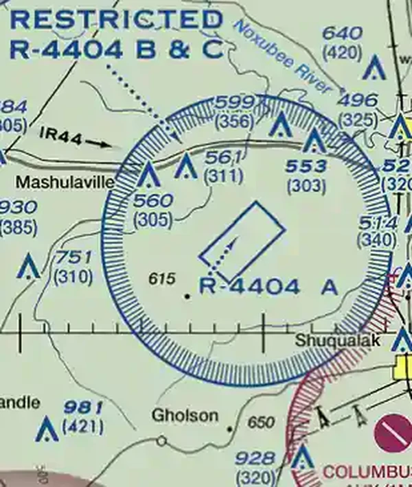
Restricted Airspace Depiction:
- Restricted airspace is depicted on aeronautical charts, including VFR sectionals, VFR Terminal Area charts, and IFR en-route low-altitude charts.
- Temporary flight restricted areas are published but never published on aeronautical charts.
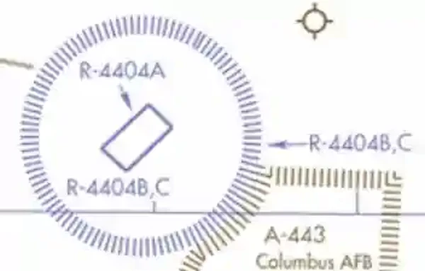
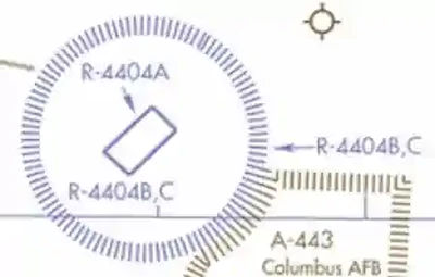
- SUA areas are shown in their entirety (within the limits of the chart), even when they overlap, adjoin, or when an area exists within another area.
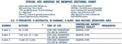
- The area is charted as an "R-" followed by a designation number and is positioned either within or immediately adjacent to the area. [/].
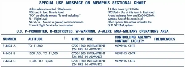
- Charts provide altitude, time of use, the controlling agency or contact facility, and its frequency when available.
- Details are available on the side of the sectional chart. []
- ATC facilities apply the following procedures when aircraft are operating on an IFR clearance (including those cleared by ATC to maintain VFR-on-top) via a route that lies within joint-use restricted Airspace:
- If the restricted area is not active and released to the controlling agency (FAA):
- The ATC facility will allow the aircraft to operate in the restricted Airspace without issuing specific clearance for it to do so.
- Approval for entry is, therefore, the controlling agency's to grant.
- Since it will not be a clearance, approval is more informal, and you should expect to hear the words "cleared."
- If the restricted area is active and not released to the controlling agency (FAA).
- The ATC facility will issue a clearance, which will ensure the aircraft avoids the restricted Airspace unless it is on an approved altitude reservation mission or has obtained its permission to operate in the Airspace and so informs the controlling facility.
- The above apply only to joint-use restricted Airspace and not to prohibited and nonjoint-use Airspace. For the latter categories, the ATC facility will issue a clearance so the aircraft will avoid the restricted Airspace unless it is on an approved altitude reservation mission or has obtained its permission to operate in the Airspace and so informs the controlling facility.
- If the restricted area is not active and released to the controlling agency (FAA):
- Restricted airspace is depicted on aeronautical charts, including VFR sectionals, VFR Terminal Area charts, and IFR en-route low-altitude charts.

Warning Areas
- Warning areas are similar in nature to restricted areas; however, the U.S. Government does not have sole jurisdiction over the airspace
- Warning areas are sections of airspace that contain activities that may be hazardous to non-participating aircraft. [//]
- The purpose of such warning areas is to warn non-participating pilots of the potential danger.
- Warning Areas lie over domestic waters, international waters, or both.
-
Warning Area Air Traffic Services:
- Air traffic control and de-confliction rest within military controlling agencies.
-
Fleet Area Control and Surveillance Facility (FACSFAC):
- A command that provides scheduling and control of all Air, surface, and subsurface activities within offshore operations areas, and all other assigned Airspace where FACSFAC has jurisdiction.
- Services support the coexistence of military, government, and non-government agencies consistent with national priorities.
- FACSFAC locations:
- VACAPES (Virginia/capes).
- San Diego (west coast).
- Pensacola (southeast).
- Pearl Harbor (Hawaii).
- Jacksonville (east).
- Non-regulatory in nature.
-
- Air traffic control and de-confliction rest within military controlling agencies.
-
Warning Area Dimensions:
-
Warning Area Lateral Limits:
- Warning areas extend from 12 Nautical Miles (NM) and outward from the coast of the United States.
- The FAA individually tailors Warning Areas.
-
Warning Area Vertical Limits:
- Charts do not depict the vertical dimensions.
- For floors and ceilings, you must reference the Special Use Airspace table on the edge of the aeronautical charts.
-
-
Warning Area Airspace Depiction:
- The following charts depict Warning Areas:
- VFR Sectionals.
- IFR En Route Low Altitude, and;
- Some Terminal Area Charts.
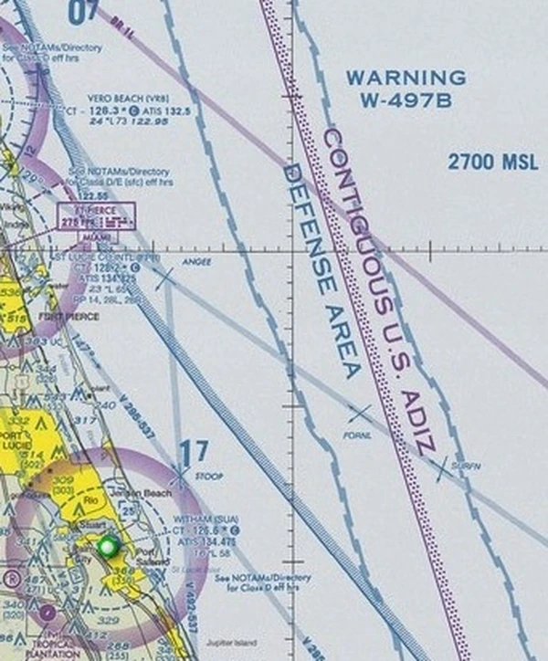
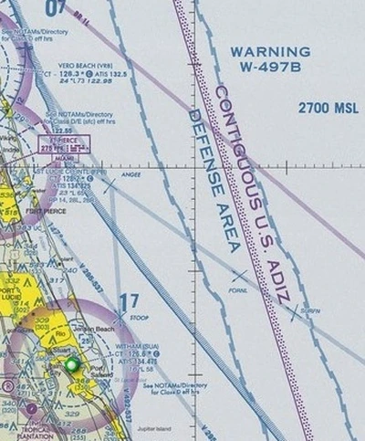
- Charts display Warning Areas in their entirety (within chart limits), even when they overlap, adjoin, or exist within another area.
- Areas are identified by type and identifying number, and are positioned either within or immediately adjacent to the area.
- The FAA labels Warning Areas with a "W-" followed by a two- or three-digit number.
- Letters following the two or three-digit number delineate subdivisions (for example, W-291A).
- A tabulation of Alert Areas (listed numerically) appears on the chart in blue.
- Charts also provide altitude, time of use, the controlling agency or contact facility, and its frequency when available.
- Each warning area is unique and may have notes printed on the chart explaining the type of activity that may take place in that location.
- The following charts depict Warning Areas:
-
Operating Rules & Pilot/Equipment Requirements:
-
Restrictions:
- The U.S. Government does not have sole jurisdiction over the airspace, but shares it with the U.S. Navy.
- Agencies may designate warning areas for joint use if they can release the area to the FAA when not in use and if the warning area lies within airspace where the FAA exercises ATC authority under ICAO agreements.
-


National Security Areas
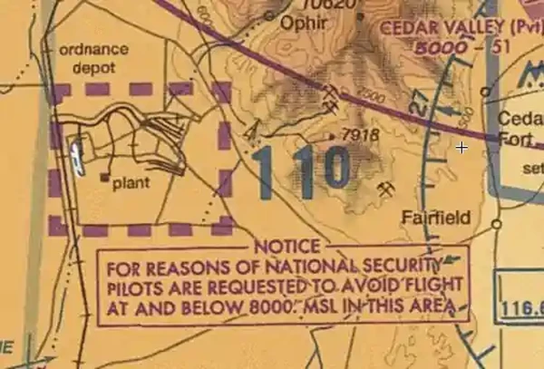
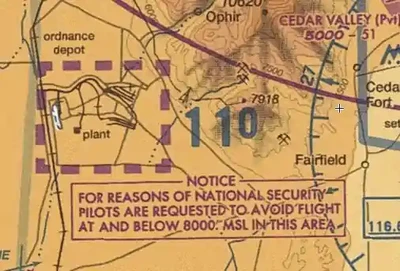
- National Security Areas (NSAs) establish sensitive locations where there is a requirement for increased security and safety of ground facilities.
- Depicted inside a magenta dash, similar to a class echo Airspace extension to surface, but larger. [/]
- Special instructions are on the sectional chart in the vicinity of the NSA. []
- For a list of critical infrastructure sites, see: https://www.cisa.gov/critical-infrastructure-sectors.
-
National Security Area Operations:
- Pilots are requested to avoid flying through NSAs voluntarily.
- Regulated under Federal Aviation Regulations (FAR) Part 99.
- Flight inside NSAs may be temporarily prohibited by regulation under the provisions of FAR 99.7 when necessary.
- Regulatory prohibitions will be issued by System Operations Security and disseminated via a Notice to Airmen (NOTAM).
-
UAS Operations Within National Security Areas:
- The FAA prohibits UAS operations over approved fixed site facilities and limits those facilities to federally owned sites. The FAA may approve UAS operations through the SGI process.
- UAS remote pilots and recreational flyers must carefully consider the need to fly over critical infrastructure and determine the legality of doing so; infractions may result in significant fines and legal actions.
- Other federal, state, or local statutes may prohibit flight near other correctional institutions.


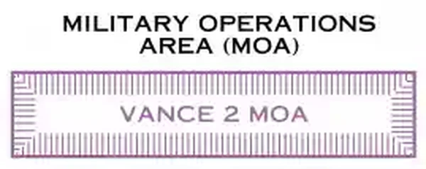
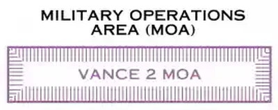
Military Operating Areas
- Military Operating Areas (MOAs) are blocks of airspace established to separate certain military training activities from Instrument Flight Rule (IFR) traffic.
- Activities contained within MOAs include:
- Air Combat Tactics.
- Air Intercepts.
- Aerobatics.
- Formation Training.
- Low Altitude Tactics (see also: Military Training Routes).
- These areas are non-regulatory and do not require pilot participation.
-
Military Operating Area Operations:
- Military Operating Areas (and warning areas for that matter) are critical to train military pilots while maintaining military readiness.
- These areas are not always active, and their status, as well as the type of activity, may change frequently, which produces hazards such as speeds over 250 knots below 10,000'.
- Examples of activities conducted in Military Operating Areas include, but are not limited to, air combat tactics, air intercepts, aerobatics, formation training, and low-altitude tactics.
- For these reasons, it is essential to understand how these blocks of airspace affect your flight.
-
Visual Flight Rules (VFR) Traffic:
- VFR pilots should exercise extreme caution when flying within Military Operating Areas during military activity.
- The pilot should contact the controlling agency when operating within 100 NM of the Military Operating Area to be crossed, as the status (active/inactive) may change frequently.
- Although civilian aircraft may fly through an active Military Operating Area, doing so is highly discouraged because of the dynamic operations in this airspace.
- Despite the safety hazard, it will cause military activity to "knock it off," resulting in wasted time and gas, which will ultimately cost taxpayers.
-
Instrument Flight Rules (IFR) Traffic:
- When a Military Operating Area is active, Air Traffic Control may clear non-participating IFR traffic through it if they can provide IFR separation.
- Otherwise, ATC will reroute or restrict non-participating IFR traffic.
- No regulation exists prohibiting civil VFR traffic from transiting an active Military Operating Area.
- Understand, however, that doing so will almost definitely stop training, costing thousands of dollars, which translates into tax dollars.
-
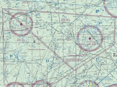
Military Operating Area Depiction:
- Sectional, VFR Terminal Area, and Low Altitude Charts depict permanent Military Operating Areas in magenta.
- Each operating area has a name and sometimes a number when segments divide a Military Operating Area. []
- Military Operating Areas are shown in their entirety (within the limits of the chart), even when they overlap, adjoin, or are within another area. []
- The areas are identified by a name, and are positioned either within or immediately adjacent to the area (i.e., Pine Hill MOA).
- A tabulation of Military Operating Areas (listed alphabetically) appears on the chart in magenta. []
- Charts also provide altitude, time of use, the controlling agency or contact facility, and its frequency when available.
- Military Operating Areas exist throughout the country and cluster most densely around military bases.
- It is not required to gain permission to enter a Military Operating Area, but you must request advisories for your own and others' safety.
- Visual Scanning and Collision Avoidance (see and avoid) remains a responsibility of all parties when operating in Visual Meteorological Conditions as per FAR 91.113(b).
- Military pilots are exempt from 14 CFR 91.303(c) and (d), which prohibits aerobatics within Class Delta or Echo surface areas and federal Airways, when operating in an active MOA.


Controlled Firing Areas
- Controlled Firing Areas (CFAs) contain activities that, if not conducted in a controlled environment, could be hazardous to non-participating aircraft.
- Examples include military artillery operations.
-
Controlled Firing Area:
- CFAs are not depicted on a map as they do not cause a non-participating aircraft to change its flight path.
- When a spotter aircraft, radar, or ground personnel determines that an aircraft might be approaching the area, the agency conducting operations discontinues the activities.
- Non-regulatory in nature.
Alert Area
- Alert areas are depicted on aeronautical charts to inform non-participating pilots of areas that may contain high volumes of pilot training, parachute jumping, glider towing, or an unusual type of aerial activity. []
- Alert areas, however, are not always established in areas that meet the above criteria.
- Alert areas are non-regulatory.
-
Congestion:
- Exercise extreme caution if operating inside alert areas.
- It is preferable to avoid the area in its entirety to avoid adding to the congestion unnecessarily.
- All activity within an alert area must be in accordance with CFRs, without waiver, and pilots of participating aircraft, as well as pilots transiting the area, must be equally responsible for collision avoidance.
- The FAA charts alert areas with a "A-" followed by a designation number, and are positioned either within or immediately adjacent to the area.
- Additional information is available on the edge of the sectional chart to which the airspace pertains. []


Obtaining Special Use Airspace Status
- Pilots can request the status of SUA by contacting the using or controlling agency.
- The charts list the frequency for the controlling agency in the margins of the applicable IFR and VFR charts.
- An airspace NOTAM will be issued for SUA when the SUA airspace (permanent and/or temporary) requires a NOTAM for activation.
- Pilots should check ARTCC NOTAMs for airspace activation.
-
Special Use Airspace Information Service (SUAIS) (Alaska Only):
- The SUAIS is a 24-hour service operated by the military that provides civilian pilots flying VFR with information regarding military flight operations in certain MOAs and restricted Airspace within central Alaska.
- The service includes "near real-time" information on military flight activity in the interior Alaska MOA and Restricted Area complex.
- SUAIS also includes information on artillery firing, known helicopter operations, and unmanned aerial vehicle operations.
- Pilots flying VFR are encouraged to use SUAIS.
- See the Alaska Chart Supplement for hours of operation, phone numbers, and radio frequencies.
- Special use Airspace scheduling data for preflight planning is available via the FAA SUA website.
- Pilots may also call or access Flight Service via phone/internet for airspace schedule information.
Special Use Airspace Interactive Scenario
Interactive Scenario
Loading scenario details...
Decision 1
0%
Scenario Complete
Special Use Airspace Knowledge Check
Private Pilot

Core Knowledge Review
Review the foundational knowledge, key concepts, and practical considerations for Special Use Airspace.
Foundational
Immediate Feedback
Answer Explanations
Commercial Pilot

Advanced Application
Apply your knowledge of Special Use Airspace to advanced operational scenarios, risk management, and aeronautical decision-making.
Advanced
Scenario Based
Risk Management
Why Take a Quiz?
Quizzes reinforce key concepts, identify knowledge gaps, and build confidence for real-world decisions in the cockpit.
Special Use Airspace Conclusion
- Special use is a classification of airspace, different from "other airspace."
- The acronym "MCPRAWN" helps pilots collectively remember the types of special use airspace.
- Military Operating Area.
- Controlled Firing Area.
- Prohibited Area.
- Restricted Area.
- Alert Area.
- Warning Area.
- National Security Area.
- Remember, no person may operate an aircraft within a prohibited area unless granted authorization by the using agency, which is the U.S. Government or the Military (Not even ATC can grant you access to enter!).
- Restricted airspace differs in that operations are not wholly prohibited but are subject to restrictions.
- Special use airspace status is accessed through the FAA's SUA website or with future advanced avionics.
- Special Use Airspace is not all depicted the same:
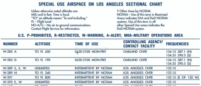
- Prohibited, Restricted, and Warning Areas are presented in blue and listed numerically for the U.S. and other countries.
- Restricted, Danger, and Advisory Areas outside the U.S. are tabulated separately in blue.
- The chart shows a tabulation of Alert Areas (listed numerically) and Military Operations Areas (MOA) (listed alphabetically) in magenta.
- Restricted areas are published in the Federal Register and constitute 14 CFR Part 73.
- Warning areas are similar to Military Operating Areas and are, at times, used for the same reasons.
- Do not become complacent in or around an alert area.
- Pilots of participating aircraft and pilots transiting the area are equally responsible for always maintaining a visual scan and collision avoidance.
- Always check Temporary Flight Restrictions before the flight to modify the standoff distance from certain special use airspace as required.
- When not active, the Airspace is released back to the FAA Air Traffic Control system for utilization.
- Still looking for something? Continue searching:
Special Use Airspace References
- Federal Aviation Administration - Pilot/Controller Glossary.
- Aeronautical Information Manual (3-4-1) General.
- Aeronautical Information Manual (3-4-2) Prohibited Areas.
- Aeronautical Information Manual (3-4-3) Restricted Areas.
- Aeronautical Information Manual (3-4-4) Warning Areas.
- Aeronautical Information Manual (3-4-5) Military Operations Areas.
- Aeronautical Information Manual (3-4-6) Alert Areas.
- Aeronautical Information Manual (3-4-7) Controlled Firing Area.
- Aeronautical Information Manual (3-4-8) National Security Areas.
- Aeronautical Information Manual (3-4-9) Obtaining Special Use Airspace Status.
- Aeronautical Information Manual (5-6-1) National Security.
- AeroNav Products - Aeronautical Chart User's Guide.
- AOPA - Coming To The Cockpit: Real-Time Special Use Airspace Updates.
- AOPA - "Lights Out".
- AOPA - Know Before You Go: Navigating Today's Airspace.
- Federal Aviation Administration Order (7400.10 Series) Special Use Airspace.
- Federal Aviation Administration Order (7400.9) Airspace Designations and Reporting Points.
- Federal Aviation Administration Order (7610.4) Special Military Options.
- Federal Aviation Regulations (Part 73 Subpart B) Restricted Areas.
- Federal Aviation Regulations (Part 73 Subpart C) Prohibited Areas.
- Federal Aviation Regulations (91.113) Right-of-way rules: Except water operations.
- Federal Aviation Regulations (91.133) Restricted and prohibited areas.
- Federal Aviation Regulations (91.303) Aerobatic flight.
- Federal Aviation Regulations (99) Security Control of Air Traffic.
- Federal Aviation Administration - Special Use Airspace Website.
- Instrument Flying Handbook (1-2) Airspace Classification.
- OPNAVINST (3770.2) Airspace Procedures and Planning Manual.
- SkyVector.com.