Other Airspace
Airspace may be considered as 'other' when not otherwise designated by a class or as special use, but necessary to curtail some aviation operations.
Introduction to Other Airspace
- Other airspace areas are those not specifically classified
- Wildlife & Recreational Areas are established due to the high volume of scenic tour flights and/or to protect noise sensitive wildlife.
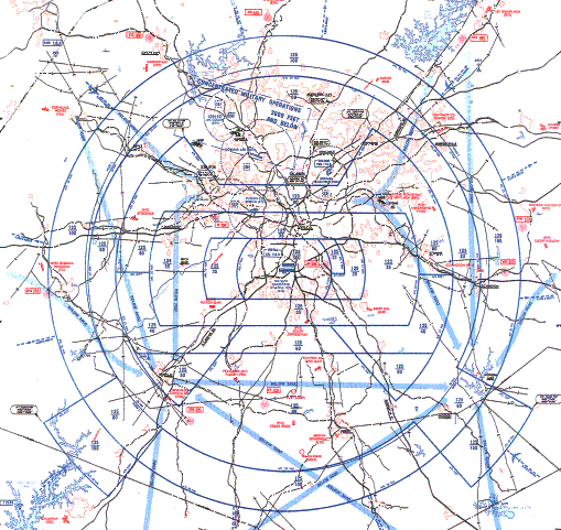
- Terminal Radar Service Areas are delineated airspace in which radar and ATC services (radar vectoring, sequencing, and separation) are made available for pilots under IFR and participating VFR aircraft.
- Airport Advisory Area & Services are provided at airports without an operating control tower that have certified automated weather reporting via voice capability.
- The Military Training Route Program is a joint venture by the Federal Aviation Administration (FAA) and the Department of Defense (DOD), developed for use by military aircraft to gain and maintain proficiency in tactical "low-level" flying.
- Parachute Jump Aircraft Areas are sections of airspace set aside to contain jump operations.
- Temporary Flight Restrictions are issued to clear airspace for the purpose of security or safety.
- Published VFR Routes are developed for transitioning around, under, and through complex airspace (such as class Bravo) through a number of FAA and industry initiatives.
- Air Defense Identification Zones are areas of airspace in the vicinity of U.S. boundaries, over land or water, in which the ready identification, location, and control of all aircraft (except Department of Defense and law enforcement aircraft) is required in the interest of national security.
- Special Air Traffic Rules (SATR) and Special Flight Rules Areas (SFRA) prescribe special air traffic rules for aircraft operating within the boundaries of certain designated airspace.
- Weather Reconnaissance Areas are airspace areas with defined dimensions and published by a NOTAM, which is established to support weather reconnaissance/research flights.
- Aircraft Hazard Areas are used by air traffic control to segregate air traffic from a launch vehicle.
- When you have a solid understanding of Other Airspace, compare your knowledge against the Private Pilot (Airplane) or Commercial Pilot (Airplane) Airman Certification Standards.
- Think you've got a solid understanding of other airspace? Don't miss the other airspace knowledge quiz below and the topic summary.
Other Airspace Key Highlights
- Other airspace categories include specialized or designated airspace areas established for unique operational, safety, or security purposes.
- Special use airspace includes prohibited areas, restricted areas, warning areas, military operations areas, and alert areas.
- Controlled firing areas contain activities that may be hazardous to aircraft but are suspended when aircraft are detected nearby.
- Temporary Flight Restrictions (TFRs) may be established for security, disaster response, airshows, or special events.
- National security areas request pilots avoid flight operations over sensitive ground facilities when possible.
- Military training routes support high-speed or low-altitude military flight operations and require heightened pilot vigilance.
- Parachute jump areas, glider operations, and other special activity zones may increase operational hazards within designated airspace.
- Pilots should review current NOTAMs, charts, and flight planning information to identify airspace restrictions before flight.
- Violations of restricted or prohibited airspace can result in enforcement actions and serious safety or security concerns.
- Understanding other airspace categories improves situational awareness, regulatory compliance, and overall flight safety.
Wildlife & Recreational Areas
- Wildlife and Recreational Areas protect noise-sensitive wildlife from aviation operations. []
-
Pilot Advisories on Bird and Other Wildlife Hazards:
- Many airports advise pilots of other wildlife hazards caused by large animals on the runway through the Chart Supplement U.S. and the NOTAM system.
- If you observe deer or other large animals near movement areas, advise the FSS, tower, or airport management.
- Also, contact the nearest FAA ARTCC, FSS, or tower (including non-Federal towers) regarding large flocks of birds and report the following:
- Geographic location.
- Bird type.
- Approximate numbers.
- Altitude.
- Direction of bird flight path.
- Also, contact the nearest FAA ARTCC, FSS, or tower (including non-Federal towers) regarding large flocks of birds and report the following:
-
Flights Over Charted U.S. Wildlife Refuges, Parks, and Forest Service Areas:
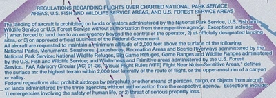
- The landing of aircraft on lands or waters administered by the National Park Service, U.S. Fish and Wildlife Service, or U.S. Forest Service without authorization from the respective agency is prohibited except:
- When forced to land due to an emergency beyond the control of the operator.
- At officially designated landing sites.
- An approved official business of the Federal Government.
- Pilots are requested to maintain a minimum altitude of 2,000' above the surface of the following:
- National Parks.
- Monuments.
- Seashores.
- Lakeshores.
- National Park Service administered Recreation Areas and Scenic Riverways.
- National Wildlife Refuges.
- Big Game Refuges.
- U.S. Fish and Wildlife Service administered Game Ranges and Wildlife Ranges.
- U.S. Forest Service administered Wilderness and Primitive areas.
- FAA Advisory Circular AC 91-36, Visual Flight Rules (VFR) Flight Near Noise Sensitive Areas, defines the surface of a national park area (including parks, forests, primitive areas, wilderness areas, recreational areas, national seashores, national monuments, national lakeshores, and national wildlife refuge and range areas) as: the highest terrain within 2,000' laterally of the route of flight, or the uppermost rim of a canyon or valley.
- Federal statutes prohibit certain types of flight activity and/or provide altitude restrictions over designated U.S. Wildlife Refuges, Parks, and Forest Service Areas.
- These designated areas, for example, Boundary Waters Canoe Wilderness Areas, Minnesota; Haleakala National Park, Hawaii; Yosemite National Park, California; and Grand Canyon National Park, Arizona, are charted on Sectional Charts.
- Federal regulations also prohibit airdrops by parachute or other means of persons, cargo, or objects from aircraft on lands administered by the three agencies without authorization from the respective agency except when:
- Emergencies involving the safety of human life.
- Threat of serious property loss.
- The landing of aircraft on lands or waters administered by the National Park Service, U.S. Fish and Wildlife Service, or U.S. Forest Service without authorization from the respective agency is prohibited except:
-
Wildlife and Recreational Area Depiction:
- Wildlife and recreational areas are depicted on sectional charts and Terminal Area Charts.
-
Sectional Chart Depiction:
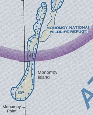
- These sensitive areas are indicated on the sectional with lines of blue dots. []
- This depiction is not located on the sectional legend but on the chart, as applicable.
- Notice that the minimum altitude for flyover is requested to be 2,000' AGL.
- These sensitive areas are indicated on the sectional with lines of blue dots. []
-
Terminal Area Charts:
- Depicted the same as on a sectional chart.
- The sectional will have brief notes and depictions that indicate restrictions. []
- The Chart Supplement U.S. supplement mentions these restrictions as well. []
- A violation could result in stiff fines.
-
Remote-Piloted Aircraft Environmental Best Practices:
- Since most UAS operations are at low altitudes, hazards, risks, and potential environmental factors may be encountered more frequently.
- In addition to the Bird Hazards and flight over National Refuges, Parks, and Forests, consider the following:
-
Flight Near Protected Conservation Areas:
- UAS, if misused, can have devastating impacts on protected wildlife. UAS operators may check for conservation area airspace restrictions on the B4UFLY mobile app.
-
Flight Near Noise Sensitive Areas:
- Plan UAS operations and flight paths to avoid prolonged or repetitive flight at low altitudes near noise-sensitive areas.
- As described in FAA Order JO 1050.1, Environmental Impact: Policies and Procedures, an area is "noise sensitive" if noise interferes with any normal activities associated with the area's use.
- Reference: FAA Order JO 1050.1, Environmental Impact: Policies and Procedures.
- To the extent consistent with FAA safety requirements, operators should observe best practices developed by the National Park Service, U.S. Fish and Wildlife Service, U.S. Forest Service, and National Oceanic and Atmospheric Administration when operating above areas administered by those agencies. The National Park Service provides additional guidance at their Unmanned Aircraft Systems website: https://www.nps.gov/subjects/sound/uas.htm.
-
- Some bird species have shown the potential to attack UAS that approach their nesting and hunting areas too closely.
- The birds most likely to attack sUAS are raptors such as hawks, eagles, and falcons.
- Aggressive bird attacks may damage UAS propellers or other critical equipment, resulting in sudden power loss or engine failure.
- Remote pilots and recreational flyers should consider reviewing engine-out procedures, especially when operating near high bird concentrations.


Terminal Radar Service Area
- Terminal Radar Service Areas, or TRSAs, are delineated airspace in which radar and ATC services (radar vectoring, sequencing, and separation) are available for pilots under IFR and participating VFR aircraft.
- TRSAs were originally part of the Terminal Radar Program at selected airports.
- Terminal Radar Service Areas were never subject to the rule-making process and, consequently, are not contained in 14 CFR Part 71 nor Part 91 and are not considered part of the airspace classification system.
- Part of the Airport Radar Service Area (ARSA) program was to replace the TRSAs.
- The ARSA requirements became relatively stringent, and TRSAs had to meet ARSA criteria before being converted.
- As they do not fit into any airspace classes, they will continue to be a non-part 71 airspace area where participating pilots can receive additional radar services, which have been redefined as a TRSA service.
- Often, TRSAs convert to Class Bravo or Class C airspace.
- The primary airport(s) within the TRSA become(s) Class D airspace.
- The remaining portion of the TRSA overlies other controlled airspace, normally Class Echo airspace beginning at 700 or 1,200' and established to transition to/from the en-route/terminal environment as dark gray circles that look like Class Bravo airspace. []
-
TRSA Participation:
- Pilots operating under VFR are encouraged (but not required) to the radar approach control and avail themselves of the TRSA services.
- See Chapter 4 of the Aeronautical Information Manual, Air Traffic Control, for details and procedures.
-
TRSA Airspace Depiction:
- TRSAs are depicted on VFR sectional and terminal area charts and listed in Chart Supplement U.S..
- A solid black line and altitudes for each segment depict the TRSA.
- The Class D portion is charted with a blue segmented line.
-
Radar Sequencing and Separation Service:
- Implemented at certain terminal locations as advertised in the U.S. Chart Supplement.
- It provides separation between all participating VFR and all IFR aircraft operating within the airspace defined as the Terminal Radar Service Area (TRSA).
- Pilot participation is encouraged but not mandatory.
- If an aircraft does not want this service, state "Negative TRSA Service" on initial contact or as appropriate.
- Participating VFR aircraft is separated from IFR and other participating VFR aircraft by one of the following:
- 500' vertical separation.
- Visual separation.
- Target resolution (a process to ensure that correlated radar targets do not touch).
- Participating aircraft must maintain an altitude when assigned, and ATC may assign altitudes that do not conform to FAR Part 91.159 (VFR cruising altitude or flight level).
- When the altitude restriction no longer applies, ATC will advise the pilot to "Resume Appropriate VFR Altitudes."
- Pilots must then return to appropriate 91.159 altitudes as soon as practicable.
- When an altitude is not assigned, the pilot should coordinate with ATC before any altitude change.
- Within the TRSA, traffic information is observed, but unidentified targets will, to the extent possible, be provided.
- Within the TRSA, ATC provides traffic information with unidentified targets provided to the extent possible.
- Departing aircraft should inform ATC of their intended destination and/or flight route and proposed cruising altitude.
- ATC will normally advise participating VFR aircraft when leaving the airspace.
- Unless otherwise indicated, traffic information service will continue.
- Class C Service: provides, in addition, approved separation between aircraft and sequencing for VFR arrivals to the primary airport.
- Class B Service: provides, in addition, approved separation between aircraft based on IFR, VFR, and/or weight and sequencing of VFR arrivals to the primary airport(s).
Airport Advisory Area & Services
- Airport advisory services are available to pilots at airports without an operating control tower with certified automated weather reporting via voice capability.
- When no control tower is in operation, and a pilot appears unaware of this fact, inform them (NO CONTROL TOWER IN OPERATION).
- Participation in any advisory service is not mandatory but is highly encouraged to improve safety for everyone operating around busy General Aviation airports.
- When requested, observed information is provided ("Landing gear appears to be down and in place").
- There are two types depending on the location of the FSS and communication capabilities:
-
Airport Advisory Communications:
- When making initial contact, pilots are informed which services are available if the requested service is unavailable.
- "[Airport name] Airport Advisory is not available, [Service] available."
- At airports with commissioned automated weather with continuous automated voice capability, instruct the pilot to monitor the automated broadcast and advise intentions:
- "Monitor [Location] automated weather [Frequency]. Advise intentions."
- Provide the appropriate non-weather elements when the pilot indicates receipt of automated weather.
- If the pilot reports that the automated weather is out of service, provide the last reported weather and the appropriate non-weather elements.
- "Monitor [Location] automated weather [Frequency]. Advise intentions."
- Advise the pilot that the requested airport advisory/RAIS service is unavailable. Provide CTAF frequency and/or the automated weather frequency when available. When not available, issue the last known surface condition and altimeter.
- "[Airport Name] AIRPORT ADVISORY or AIRPORT INFORMATION NOT AVAILABLE. CONTACT [Airport Name] CTAF [Frequency]."
- During initial contact, provide only the appropriate non-weather elements if the pilot indicates receipt of automated weather. Do not provide weather information unless specifically requested by the pilot or a special report is transmitted.
- RAIS: Pilot: "Green Bay radio, Cessna 12RG, ten northeast, landing Eau Claire, request airport information; I have the automated weather."
- FSS: "Cessna 12RG, Eau Claire airport information, your traffic is a Cessna 172 entering downwind and a Convair 660 reported on final, both one minute ago. There is an airport maintenance vehicle."
- If additional pilots initiate contact a short time after airport advisory services were provided, determine if the new pilot(s) copied the information when it was provided.
- Do not repeat the information if the new pilot responds in the affirmative.
- If the new pilot acknowledges the airport advisory information and then requests specific information, provide only the information requested to reduce frequency clutter while ensuring that the pilots are aware of the situation as it changes.
- Final Guard is a service provided with airport advisory only during significant and fast-changing weather conditions that may affect landing and takeoff operations.
- Where AFIS is available, confirm receipt of the current AFIS information if the pilot does not initially state the appropriate AFIS code. Issue the current AFIS information to pilots who cannot receive the AFIS or pilots who do not have the information.
- "Verify you have information ALFA."
- If the pilot requests special VFR clearance, provide the appropriate elements and follow the procedures in Chapter 4, Section 5, Special VFR Operations.
- When making initial contact, pilots are informed which services are available if the requested service is unavailable.
-
Local Airport Advisory (LAA):
- Local Airport Advisory (LAA) service is available only in Alaska.
- LAA operates within 10 statute miles of an airport where a control tower is not operating but where an FSS is located.
- At these locations, FSS provides LAA service for arriving and departing aircraft:
- Ground-to-air communication on the common traffic advisory frequency (CTAF);
- Automated weather reporting with voice broadcasting;
- A continuous automated weather data display and;
- Other continuous, direct reading instruments or manual observations are available to the specialist.
- Final Guard will automatically be provided during periods of fast-changing weather.
-
Final Guard:
- It begins when the aircraft reports "on final" or "taking the active runway" until the airport reports "on the ground" or "airborne."
- It is crucial to inform FSS when you are airborne/on deck.
- Wind and altimeters are provided; however, pilots must continue monitoring ATIS.
-
Remote Airport Information Service (RAIS):
- Provides short-term support for short-term special events like small to medium fly-ins and special events by facilities that are not located on the landing airport but have:
- Communication capability and;
- Automated weather reporting available to the pilot at the landing airport.
- FAA policy requires pilots to access the current automated weather before requesting remote ATC services at non-towered airports.
- The pilot must comply with the Federal Aviation Regulations (FARs) if landing clearance is required.
- Advertised by NOTAM(D) only.
- The FSS will not have access to a continuous readout of the current winds and altimeter; therefore, RAIS does not include weather and/or Final Guard service.
- However, known traffic, special event instructions, and all other services are provided.
- Airport authority and/or managers should request RAIS support on official letterhead directly with the manager of the FSS that will provide the service at least 30 days in advance.
- Approval authority rests with the FSS manager, workload, and resource permitting.
- For more information, see the Aeronautical Information Manual (4-1-9), which discusses airport traffic advisory practices without operating control towers.
- When requesting remote ATC services, current policy requires that a pilot monitor the automated weather broadcast at the landing airport before requesting ATC services.
- When appropriate, the FSS automatically provides Final Guard during LAA/Remote Airport Advisory (RAA) operations.
- Final Guard is a value-added wind/altimeter monitoring service that provides an automatic wind and altimeter check during weather situations when the pilot reports on-final or taking the active runway.
- During the landing or takeoff operation, when the winds or altimeter are actively changing, the FSS will blind broadcast significant changes when the specialist believes the change might affect the operation.
- Pilots should acknowledge the first wind/altimeter check, but due to cockpit activity, no acknowledgment is expected for the blind broadcasts.
- It is prudent for a pilot to report on the ground or airborne to end the service.
- Provides short-term support for short-term special events like small to medium fly-ins and special events by facilities that are not located on the landing airport but have:
Military Training Routes
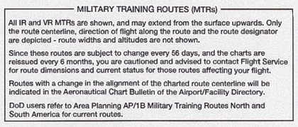
- The Military Training Route (MTR) Program is a joint venture by the Federal Aviation Administration (FAA) and the Department of Defense (DOD), developed for use by military aircraft to gain and maintain proficiency in tactical "low-level" flying.
- These low-level training routes are generally established below 10,000' Mean Sea Level (MSL) for speeds over 250 knots to accommodate both Visual Flight Rules (VFR) and Instrument Flight Rules (IFR).
- Route segments, however, may be defined at higher altitudes for route continuity during descent, climb-out, mountainous terrain, etc.
- Routes are identified and charted with letters and numbers to identify route characteristics quickly.
- In order to safely integrate, pilots utilizing MTRs are held to strict standards during the conduct of the route, as published in the Flight Information Publications (FLIP).
-
Route Information:
-
Visual Routes (VR):
- VR, or VFR routes, are designed to be flown at 1,500' AGL and below.
- Conducted under VFR, except when flight visibility must be 5 Statute Miles or more, and flights shall not be conducted below a ceiling of less than 3,000' AGL.
- Pilots departing on IFR clearances to fly VRs are required to file to the fix/radial/distance of entry.
- Pilots transitioning to IFR must have a previously filed IFR flight plan on file from their point's appropriate fix/radial/distance upon exiting a VR.
- For VR routes, the pilot will notify the nearest flight service station (255.4 megahertz (MHz)) upon entering the route with the entry time, number/type of aircraft, exit fix, and estimated exit time.
- Pilots of aircraft operating on a VR route will adjust their transponder to code 4000 unless otherwise assigned by ATC.
-
Instrument Routes (IR):
- IR, or IFR routes, are designed to be flown above 1,500' Above Ground Level (AGL).
- Conducted per IFR regardless of weather conditions.
- Pilots require a specific Air Traffic Control (ATC) entry clearance before entering.
- Pilots shall be responsible for obtaining an IFR clearance before exiting an IR route.
- Specific route information is contained in the Department of Defense (DOD) Flight Information Publication (FLIP) AP/1B along with additional MTR (slow routes/air refueling routes) information or through the 28-Day National Airspace Systems Resources (NASR) Subscription.
- MTRs for particular chart pairs (ex., L1/2, etc.) are alphabetically and then numerically tabulated.
- The tabulation includes a unique identification of MTR type and altitude range.
- Route width varies for each MTR and can vary from 4 to 16 miles on either side of the charted MTR centerline.
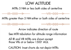
- Route segments with a width of 5 Nautical Mile (NM) or less, both sides of the centerline, are shown by a .02" line.
- Route segments with a width greater than 5 NM, either or both sides of the centerline, are shown by a .035" line.
- A thorough review of FLIP AP/1B, temporary route advisories, Chart Updating Manual (CHUM), and Chart Updating Manual Supplement (CHUMSUPP) is essential to ensure flight safety and maximum training from each sortie.
-
-
Special Military Activity Routes (SMARs):
- SMARs are airspace areas designated for unmanned aircraft (UAS) training.
- Aircraft operating in a SMAR may be accompanied by military or other aircraft that provide the pilots of the Unmanned Aircraft Systems visual observation information about other aircraft operations near them.
- Further information on SMAR charting can be found on the border of the printed VFR Sectional Chart and in the FAA Aeronautical Chart Users' Guide available online at: https://www.faa.gov/air_traffic/flight_info/aeronav/digital_products/aero_guide/.
-
Route Identification:
- MTRs are identified by their flight rules and segment altitudes associated with arrows that indicate the direction of flight along the route.
- Routes numbered 001 to 099 are shown as IR1 or VR99, eliminating the initial zeros.
- MTRs with no segment above 1,500' AGL are identified with four number characters (IR1206/VR1207)
- MTRs that include one or more segments above 1,500' AGL are identified with three number characters (IR206/VR207)
- Alternate IR/VR routes or route segments are identified by using the basic/principal route designation followed by a letter suffix, e.g., IR008A, VR1007B, etc.
-
Route Charting:
- IFR Enroute Low Altitude Chart:
- This chart will depict the centerline of all IR and VR routes that accommodate operations above 1,500' Above Ground Level (AGL).
- MTRs are not shown on inset charts or IFR Enroute High Altitude Charts.
- VFR Sectional Aeronautical Charts/Terminal Area Chart:
- Depict military training activities such as IR and VR information.
- These charts will depict MTR centerlines in black.
- Special Military Activity Routes (SMARs) may also be charted on the VFR Sectional Chart, showing the extent of the airspace allocated to the associated IFR Military Training Routes within which the Department of Defense conducts periodic operations involving Unmanned Aircraft Systems.
- Area Planning (AP/1B) Chart (DOD Flight Information Publication):
- This chart is published by the National Geospatial-Intelligence Agency (NGA), primarily for military users, and contains detailed information on IR and VR routes.
- See NGA products for more.
- The designator IR or VR is not repeated when two or more routes are established over the same airspace.
- Example: IR201-205-227.
- Alternate IR/VR routes or route segments are identified by using the basic/principal route designation followed by a letter suffix.
- Example: IR008A, VR1007B.
- IFR Enroute Low Altitude Chart:
-
Military Training Route Conduct:
- Pilots shall familiarize themselves with the route and are responsible for remaining within the route's structure.
- If the aircraft departs the defined route by exit or upon completion, FAR 91.117d (maximum speed) applies.
- Caution is advised when climbing above the MTR structure, as this may place aircraft in close proximity to airway traffic.
- Operations will be at the minimum speed required to accomplish the mission.
- Unless otherwise delineated in an MTR special operating procedure, aircrew shall avoid charted uncontrolled airports by 3 NM laterally or 1,500' AGL vertically.
- Note the avoidance criteria for airfields and the need to remain clear of published noise-sensitive areas.
- Aircrew shall avoid Class Bravo, Charlie, and Delta airspace.
- Aircrew shall minimize disturbance to persons/property on the ground.
- Route entries shall only be at published entry/alternate entry points.
- All route exits shall only be at published exit/alternate exit points.
- Pilots shall familiarize themselves with the route and are responsible for remaining within the route's structure.
-
Flight Information Publications:
- Department of Defense Flight Information Publications describe IR/VR routes through charts and narratives, and the FAA provides information regarding these routes to all users via IFR and VFR charts.
- MTR information from the DOD FLIPs is available for pilot briefings at FSS and many airports.
- Route width information for IR and VR MTRs is also available in the FLIP AP/1B and additional MTR (slow routes/air refueling routes) information.
- For the latest information regarding publication availability, visit the NGA Web site:


Parachute Jump Aircraft Area
- Parachute Jump Aircraft Areas are sections of airspace set aside to contain jump operations.
-
Prachute Jump Operations:
- Pilots of aircraft engaged in parachute jump operations must report all altitudes in mean sea level or flight level, as appropriate, to enable ATC to provide meaningful traffic information.
- There is no substitute for alertness near a jump location; monitor the CTAF and keep your scan.
- Pilots conducting parachute operations must be alert, look for other traffic, and exchange traffic information as Traffic Advisory Practices at Airports Without Operating Control Towers recommends.
- In addition, pilots should avoid releasing parachutes while in an airport traffic pattern when other aircraft are in that pattern.
- Pilots should make appropriate broadcasts on the designated Common Traffic Advisory Frequency (CTAF) and monitor that CTAF until all parachute activity has terminated or the aircraft has left the area.
- Before commencing a jump operation, the pilot should broadcast the aircraft's altitude and position to the airport, the approximate relative time when the jump will commence and terminate, and listen to the position reports of other aircraft in the area.
- No person may make a parachute jump, and no pilot-in-command may allow a parachute jump to be made from that aircraft in or into Class A, Class B, Class C, or Class D airspace without, or in violation of, the terms of an ATC authorization issued by the ATC facility having jurisdiction over the airspace (See 14 CFR Part 105).
- If flying near an area of jump activity, monitor the Common Traffic Advisory Frequency (of the jump airport) to be aware of upcoming jumps and the Jumpers.
Temporary Flight Restrictions
- Temporary Flight Restrictions (TFRs) are issued to clear airspace for the purpose of security or safety
- More specifically, they:
- Protect persons and property on the surface or in the air from a hazard associated with an incident on the surface;
- Provide a safe environment for the operation of disaster relief aircraft; or
- Prevent an unsafe congestion of sightseeing and other aircraft above an incident or event which may generate a high degree of public interest
- This includes VIPs, Space Agency Operations.
- The Notice to Airmen will specify the hazard or condition that requires the imposition of temporary flight restrictions
- The type of restrictions issued will be kept to a minimum by the FAA consistent with achievement of the necessary objective
-
Issuance:
- May be issued by Air Route Traffic Control Centers (ARTCCs) via Notice to Airmen (NOTAMs) if enough warning exists
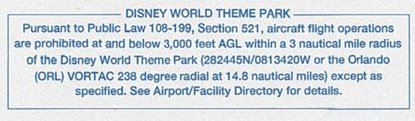
- Temporary Flight Restrictions are usually not depicted due to the short notice and short duration, but some, like Disney World, will always be published
- Usually issued 30 days in advance
- In some cases, like natural disasters, TFRs may pop-up with an estimated, but by no means firm end
- This means they may end earlier than expected, or get extended
- If you see a TFR is active-its valid; if you see a previous TFR has been removed, its no longer valid
- In some cases, like natural disasters, TFRs may pop-up with an estimated, but by no means firm end
- There is an exclusion within the TFR for if you're under ATC control
- So if you're flying into an area you're not familiar with, get flight following and you are better covered
- To preclude misunderstanding, the implementing NOTAM will contain specific and formatted information
- The facility establishing a temporary flight restrictions area will format a NOTAM beginning with the phrase "FLIGHT RESTRICTIONS" followed by: the location of the temporary flight restrictions area; the effective period; the area defined in statute miles; the altitudes affected; the FAA coordination facility and commercial telephone number; the reason for the temporary flight restrictions; the agency directing any relief activities and its commercial telephone number; and other information considered appropriate by the issuing authority
- May be issued by Air Route Traffic Control Centers (ARTCCs) via Notice to Airmen (NOTAMs) if enough warning exists
-
Imminent Hazards:
- TFRs issued in relation to imminent hazards protect persons and property in the air or on the surface from an existing or imminent hazard associated with an incident on the surface when the presence of low flying aircraft would magnify, alter, spread, or compound that hazard
- Established by or through the area manager at the ARTCC having jurisdiction over the area concerned
- The FAA accepts recommendations for the establishment of a temporary flight restrictions area under 14 CFR Section 91.137(a)(1) from military major command headquarters, regional directors of the Office of Emergency Planning, Civil Defense State Directors, State Governors, or other similar authority
- The appropriate FAA air traffic element, upon receipt of such a request, will establish a temporary flight restrictions area under 14 CFR Section 91.137(a)(1)
- Situations which warrant the extreme restrictions of 14 CFR Section 91.137(a)(1) include, but are not limited to:
- Toxic gas leaks or spills;
- Flammable agents, or fumes which if fanned by rotor or propeller wash could endanger persons or property on the surface, or if entered by an aircraft could endanger persons or property in the air;
- Imminent volcano eruptions which could endanger airborne aircraft and occupants;
- Nuclear accident or incident; and,
- Hijackings
- When hijacking situations are involved, a temporary flight restrictions area will be implemented through the TSA Aviation Command Center
- The appropriate FAA air traffic element, upon receipt of such a request, will establish a temporary flight restrictions area under 14 CFR Section 91.137(a)(1)
- The following NOTAM prohibits all aircraft operations except those specified in the NOTAM:
- Flight restrictions Matthews, Virginia, effective immediately until 9610211200. Pursuant to 14 CFR Section 91.137(a)(1) temporary flight restrictions are in effect. Rescue operations in progress. Only relief aircraft operations under the direction of the Department of Defense are authorized in the airspace at and below 5,000 feet MSL within a 2-nautical-mile radius of Laser AFB, Matthews, Virginia. Commander, Laser AFB, in charge (897) 946-5543 (122.4). Steenson FSS (792) 555-6141 (123.1) is the FAA coordination facility
-
Disaster Relief:
- Established by or through the area manager at the ARTCC having jurisdiction over the area concerned, TFRs may be issued for the operations of disaster relief
- Established by or through the area manager at the ARTCC having jurisdiction over the area concerned
- The FAA accepts recommendations from military commanders serving as regional, subregional, or Search and Rescue (SAR) coordinators; by military commanders directing or coordinating air operations associated with disaster relief; or by civil authorities directing or coordinating organized relief air operations (includes representatives of the Office of Emergency Planning, U.S. Forest Service, and State aeronautical agencies)
- Situations which warrant the restrictions associated with 14 CFR Section 91.137(a)(2) include:
- Forest fires which are being fought by releasing fire retardants from aircraft; and,
- Aircraft relief activities following a disaster (earthquake, tidal wave, flood, etc.)
- The following NOTAM example provides a safe area for fire fighting operations:
- Flight restrictions 25 miles east of Bransome, Idaho, effective immediately until 9601202359 UTC. Pursuant to 14 CFR Section 91.137(a)(2) temporary flight restrictions are in effect within a 4-nautical-mile radius of the intersection of county roads 564 and 315 at and below 3,500 feet MSL to provide a safe environment for fire fighting aircraft operations. Davis County sheriff's department (792) 555-8122 (122.9) is in charge of on-scene emergency response activities. Glivings FSS (792) 555-1618 (122.2) is the FAA coordination facility
-
Unsafe Congestion:
- Issued at the direction of the service area office director having oversight of the airspace concerned in order to prevent aircraft above an incident or event which may generate a high degree of public interest
- 14 CFR Section 91.137(a)(3) restrictions are established for events and incidents that would attract an unsafe congestion of sightseeing aircraft
- Appropriate authorities for a temporary flight restrictions establishment under 14 CFR Section 91.137(a)(3) are any of those listed above or by State, county, or city government entities
- The amount of airspace needed to protect persons and property or provide a safe environment for rescue/relief aircraft operations is normally limited to within 2,000' above the surface and within a 3-nautical-mile radius
- Incidents occurring within Class B, Class C, or Class D airspace will normally be handled through existing procedures and should not require the issuance of a temporary flight restrictions NOTAM
- Temporary flight restrictions affecting airspace outside of the U.S. and its territories and possessions are issued with verbiage excluding that airspace outside of the 12-mile coastal limits
- The following NOTAM prohibits sightseeing aircraft operations:
- Flight restrictions Brown, Tennessee, due to olympic activity. Effective 9606181100 UTC until 9607190200 UTC. Pursuant to 14 CFR Section 91.137(a)(3) temporary flight restrictions are in effect within a 3-NM radius of N355783/W835242 and Volunteer VORTAC 019 degree radial 3.7 DME fix at and below 2,500 feet MSL. Norton FSS (423) 555-6742 (126.6) is the FAA coordination facility
- The ARTCC nearest the incident site is normally the "coordination facility." When FAA communications assistance is required, the designated ARTCC will function as the primary communications facility for coordination between emergency control authorities and affected aircraft
-
Hawaii Disaster Relief:
- Hawaii disaster relief protects declared national disasters for humanitarian reasons in Hawaii, as determined by the Governor.
- When a NOTAM has been issued in accordance with this section, no person may operate an aircraft within the designated airspace unless:
- That person has obtained authorization from the official in charge of associated emergency or disaster relief response activities, and is operating the aircraft under the conditions of that authorization;
- The aircraft is carrying law enforcement officials;
- The aircraft is carrying persons involved in an emergency or a legitimate scientific purpose;
- The aircraft is carrying properly accredited news persons, and that prior to entering the area, a flight plan is filed with the appropriate FAA or ATC facility specified in the NOTAM and the operation is conducted in compliance with the conditions and restrictions established by the official in charge of on-scene emergency response activities; or,
- The aircraft is operating in accordance with an ATC clearance or instruction
- NOTAMs issued under this section are effective for 90 days or until the national disaster area designation is terminated, whichever comes first, unless terminated by notice or extended by the Administrator at the request of the Governor of the State of Hawaii or the Governor's designee
- The following NOTAM prohibits all aircraft except those operating under the authorization of the official in charge of associated emergency or disaster relief response activities, aircraft carrying law enforcement officials, aircraft carrying personnel involved in an emergency or legitimate scientific purposes, carrying properly accredited news media, and aircraft operating in accordance with an ATC clearance or instruction:
- Flight restrictions Kapalua, Hawaii, effective 9605101200 UTC until 9605151500 UTC. Pursuant to 14vCFR Section?91.138 temporary flight restrictions are in effect within a 3-nautical-mile radius of N205778/W1564038 and Maui/OGG/VORTAC 275 degree radial at 14.1-NM. John Doe 808-757-4469 or 122.4 is in charge of the operation. Honolulu/HNL 808-757-4470 (123.6) FSS is the FAA coordination facility
-
Proximity of the President and other parties:
- VIP NOTAMs protect the president and vice president as well as public figures
- No person may operate an aircraft over or in the vicinity of an area to be visited or traveled by the President, Vice President, or other public figures contrary to the restrictions established by the Administrator and published in the Notice to Airmen (NOTAM)
- The following NOTAM example prohibits all aircraft:
- Flight restrictions Stillwater, Oklahoma, June 21, 1996. Pursuant to 14 CFR Section 91.141 aircraft flight operations are prohibited within a 3-nautical-mile radius, below 2000 feet AGL of N360962/W970515 and the Stillwater/SWO/VOR/DME 176 degree radial 3.8-nautical-mile fix from 1400 local time to 1700 local time June 21, 1996, unless otherwise authorized by ATC
-
Space Agency Operations:
- Provide a safe environment for space agency operations
- When a Notice to Airmen (NOTAM) is issued in accordance with this section, no person may operate any aircraft of U.S. registry, or pilot any aircraft under the authority of an airman certificate issued by the Federal Aviation Administration, within areas designated in a NOTAM for space flight operation except when authorized by ATC
- The following NOTAM example prohibits any aircraft of U.S. registry, or pilot any aircraft under the authority of an airman certificate issued by the FAA:
- Kennedy space center space operations area effective immediately until 9610152100 UTC. Pursuant to 14 CFR Section 91.143, flight operations conducted by FAA certificated pilots or conducted in aircraft of U.S. registry are prohibited at any altitude from surface to unlimited, within the following area 30-nautical-mile radius of the Melbourne/MLB/VORTAC 010 degree radial 21-nautical-mile fix. St. Petersburg, Florida/PIE/FSS 813-545-1645 (122.2) is the FAA coordination facility and should be contacted for the current status of any airspace associated with the space shuttle operations. This airspace encompasses R2933, R2932, R2931, R2934, R2935, W497A and W158A. Additional warning and restricted areas will be active in conjunction with the operations. Pilots must consult all NOTAMs regarding this operation
-
Notes:
- The FSS nearest the incident site is normally the "coordination facility." When FAA communications assistance is required, the designated FSS will function as the primary communications facility for coordination between emergency control authorities and affected aircraft. The ARTCC may act as liaison for the emergency control authorities if adequate communications cannot be established between the designated FSS and the relief organization. For example, the coordination facility may relay authorizations from the on-scene emergency response official in cases where news media aircraft operations are approved at the altitudes used by relief aircraft
- ATC may authorize operations in a temporary flight restrictions area under its own authority only when flight restrictions are established under 14 CFR Section 91.137(a)(2) and (a)(3). The appropriate ARTCC/airport traffic control tower manager will, however, ensure that such authorized flights do not hamper activities or interfere with the event for which restrictions were implemented. However, ATC will not authorize local IFR flights into the temporary flight restrictions area
- To preclude misunderstanding, the implementing NOTAM will contain specific and formatted information. The facility establishing a temporary flight restrictions area will format a NOTAM beginning with the phrase "FLIGHT RESTRICTIONS" followed by: the location of the temporary flight restrictions area; the effective period; the area defined in statute miles; the altitudes affected; the FAA coordination facility and commercial telephone number; the reason for the temporary flight restrictions; the agency directing any relief activities and its commercial telephone number; and other information considered appropriate by the issuing authority
- Unless explicitly required (disaster/hazard areas), a VFR flight plan is a tool to potentially fly through a TFR, as you'll be in touch with ATC throughout
-
Operations Within TFRs:
- No person may operate within TFRs, unless:
- Participating in the hazard relief under the official in charge of the scene
- Law enforcement, event, or legitimate scientific officials are on board
- Operating under the ATC approved IFR flight plan
- Operation is conducted directly to or from an airport within the area or is necessitated by the impracticably of the VFR flight above or around the area due to weather, or terrain
- Notify FSS or ATC facility issuing the TFR
- The aircraft is carrying properly accredited news representatives and prior to entering the area a flight plan has been filed
- Must include aircraft identification, type, color
- Radio communication frequencies to be used
- Proposed times of entry and exit
- Names of news media or organization and purpose of flight
- Any other information requested by ATC
- Typically not depicted on sectionals
- When any information indicates that barometric pressure exceeds 31 in-Hg, no person may operate unless a waiver is granted by the Administrator for emergency reasons
- Other restrictions like being on a VFR flight plan may also apply
- No person may operate within TFRs, unless:
-
Demonstration events that may cause a TFR:
- Blue Angels
- Thunderbirds
- Golden Knights
- Olympic Games
- Annual Tournament of Roses Football Game
- World Cup Soccer
- Major League Baseball All-Star Game
- World Series
- Kodak Albuquerque International Balloon Fiesta
- Sandia Classic Hang Gliding Competition
- Indianapolis 500 Mile Race
- Any other aerial demonstration or sporting event the FAA determines to need a TFR
- Usually limited to 5 NM radius to an altitude of 17,000' MSL for aircraft, 13,000' MSL for parachute operations
- Sporting events usually limited to 3 NM radius and 2,500'
- Qualifying locations and events are generally defined as any stadium or other sporting venue having a seating capacity of 30,000 or more
-
Hazard/Disaster Areas:
- The FAA will issue a NOTAM designating an area within which temporary flight restrictions apply and specifying the hazard or condition requiring their imposition, whenever he determines it is necessary in order to:
- Protect persons and property on the surface or in the air from a hazard associated with an incident on the surface;
- Provide a safe environment for the operation of disaster relief aircraft; or
- Prevent an unsafe congestion of sightseeing and other aircraft above an incident or event which may generate a high degree of public interest
- The NOTAM will specify the hazard or condition that requires the imposition of TFRs
- When a NOTAM has been issued under condition 1 above, no person may operate an aircraft within the designated area unless that aircraft is participating in the hazard relief activities and is being operated under the direction of the official in charge of on scene emergency response activities
- When a NOTAM has been issued under condition 2 above, no person may operate an aircraft within the designated area unless at least one of the following conditions are met:
- The aircraft is participating in hazard relief activities and is being operated under the direction of the official in charge of on scene emergency response activities
- The aircraft is carrying law enforcement officials
- The aircraft is operating under the ATC approved IFR flight plan
- The operation is conducted directly to or from an airport within the area, or is necessitated by the impracticability of VFR flight above or around the area due to weather, or terrain; notification is given to the Flight Service Station (FSS) or ATC facility specified in the NOTAM to receive advisories concerning disaster relief aircraft operations; and the operation does not hamper or endanger relief activities and is not conducted for the purpose of observing the disaster
- The aircraft is carrying properly accredited news representatives, and, prior to entering the area, a flight plan is filed with the appropriate FAA or ATC facility specified in the Notice to Airmen and the operation is conducted above the altitude used by the disaster relief aircraft, unless otherwise authorized by the official in charge of on scene emergency response activities
- When a NOTAM has been issued under condition 3 above, no person may operate an aircraft within the designated area unless at least one of the following conditions is met:
- The operation is conducted directly to or from an airport within the area, or is necessitated by the impracticability of VFR flight above or around the area due to weather or terrain, and the operation is not conducted for the purpose of observing the incident or event
- The aircraft is operating under an ATC approved IFR flight plan
- The aircraft is carrying incident or event personnel, or law enforcement officials
- The aircraft is carrying properly accredited news representatives and, prior to entering that area, a flight plan is filed with the appropriate FSS or ATC facility specified in the NOTAM
- Flight plans filed and notifications made with an FSS or ATC facility under this section shall include the following information:
- Aircraft identification, type and color
- Radio communications frequencies to be used
- Proposed times of entry of, and exit from, the designated area
- Name of news media or organization and purpose of flight
- Any other information requested by ATC
- The FAA will issue a NOTAM designating an area within which temporary flight restrictions apply and specifying the hazard or condition requiring their imposition, whenever he determines it is necessary in order to:
-
UAS Operations Within TFRs:
- UAS operators should be aware that substantial fines and penalties can be levied on UAS remote pilots or recreational flyers violating a TFR
- These areas are generally depicted on aeronautical charts and will be indicated on the B4UFly and LAANC applications for UAS


Published VFR Routes
- Developed for transitioning around, under and through complex airspace (such as class Bravo) through a number of FAA and industry initiatives []
- Frequently used interchangeably, each type of published VFR route serves an operational requirement and posses unique requirements for their use
- There are three types of routes:
- VFR Flyways, and their associated Flyway Planning Charts were developed from the recommendations of a National Airspace Review Task Group;
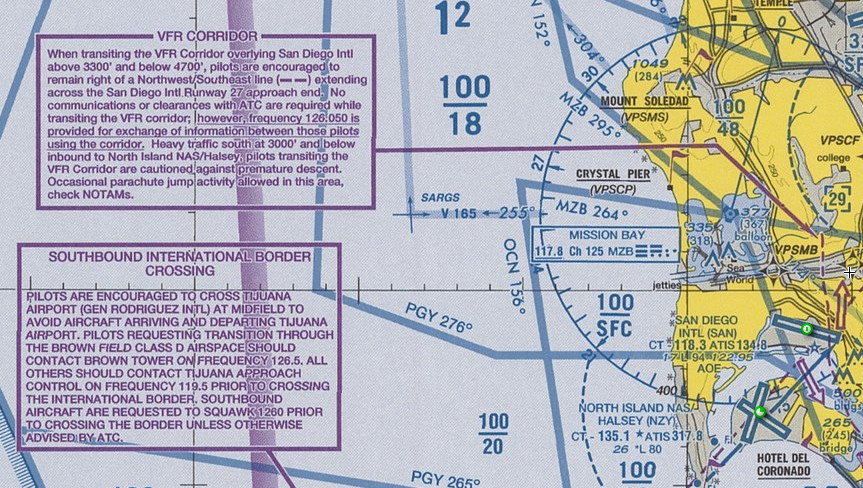
- VFR Corridors, designed for the passage of uncontrolled traffic through class B airspace areas, and;
- VFR Transition Route, designed to accommodate VFR traffic through certain Class B airspace areas such as Seattle, Phoenix, and Los Angeles
-
VFR Flyways:
- A VFR Flyway is defined as a general flight path not defined as a specific course, for use by pilots in planning flights into, out of, through or near complex terminal airspace to avoid Class B airspace
- An ATC clearance is NOT required however, when operating beneath Class B airspace, communications must be established and maintained between your aircraft and any control tower while transiting the Class B, Class C, and Class D surface areas of those airports under Class B airspace
- VFR Flyways are depicted on the reverse side of some VFR Terminal Area Charts (TACs), commonly referred to as Class B airspace charts []
- These charts identify VFR Flyways designed to help VFR pilots avoid major controlled traffic flows
- They may further depict multiple VFR routings throughout the area which may be used as an alternative to flight within Class B airspace
- The ground references provide a guide for improved visual navigation
- These routes are not intended to discourage requests for VFR operations within Class B airspace but are designed solely to assist pilots in planning for flights under and around busy Class B airspace without entering ClassB airspace.
- Remember, suggested routes are not sterile of other traffic
- The entire Class B airspace, and the airspace underneath it, may be heavily congested with many different types of aircraft
- Pilot adherence to VFR rules must be exercised at all times
- Communications must be established and maintained between your aircraft and any control tower while transiting Class-C or Class D surface areas of airports under Class B airspace
-
VFR Corridors:
- Defined as an airspace passage through class B airspace, with defined boundaries both lateral and vertical in which aircraft may operate without an ATC clearance or communication with air traffic control
- These corridors are, in effect, a "hole" through Class B airspace []
- A classic example would be the corridor through the Los Angeles Class B airspace, which has been subsequently changed to a Special Flight Rules Area (SFRA)
- A corridor is surrounded on all sides by Class B airspace and does not extend down to the surface like a VFR Flyway
- Because of their finite lateral and vertical limits, and the volume of VFR traffic using a corridor, extreme caution and vigilance must be exercised
- Due to their complexity and traffic requirements inside of Class Bravo airspace, it has not been possible to incorporate VFR corridors in the development or modification of Class B airspace in recent years
-
VFR Transition Routes:
- To accommodate VFR traffic through terminal airspace, VFR Transition Routes were developed.
- A VFR Transition Route is defined as a specific flight course depicted and described on a TAC and/or VFR Flyway Planning Chart.
- Communication with ATC where the route transitions Class B, Class C, and/or Class D airspace is required.
- In addition to communication requirements, a clearance is required to operate in Class B airspace.
- VFR Transition Routes may include published altitudes or ATC-assigned altitudes.
- Per 14 CFR section 91.123, pilot compliance is expected for all route and altitude restrictions as published or assigned by ATC.
- VFR Transition Route and altitude assignments do not relieve pilots from their duty to comply with 14 CFR section 91.119.
- Pilots are expected to request an alternate clearance if necessary for compliance.
- These routes are designed to show the pilot where to position the aircraft where an ATC assignment or clearance for the route can normally be expected with minimal or no delay []
- Until ATC authorization is received, pilots must remain clear of Class B airspace
- On initial contact, pilots should advise ATC of their position, altitude, route name desired, and direction of flight
- For secondary airports underlying or in close proximity to Class B or Class C airspace, VFR Transition Routes may be developed and depicted for arrivals/departures
- These arrivals/departures may be requested from or assigned by ATC.
- To accommodate VFR traffic through terminal airspace, VFR Transition Routes were developed.

Air Defense Identification Zones
- An Air Defense Identification Zone (ADIZ) is an area of airspace in the vicinity of U.S. boundaries, over land or water, in which the ready identification, location, and control of all aircraft (except Department of Defense and law enforcement aircraft) is required in the interest of national security
- All aircraft must meet certain requirements to facilitate early identification when operating into, within, and across an ADIZ, as described in 14 CFR 99
- National security, in the control of air traffic is governed by 14 CFR Part 99
- The different types of ADIZ are areas of airspace over land or water (domestic/coastal), extends upward from the surface, within which the ready identification, the location, and the control of aircraft are required
- ADIZ dimensions are depicted on aeronautical charts for easy of identification
- Operations are permitted within these areas provided certain requirements are met (with some exception)
- The location and operations within this airspace must be understood as violations can result in consequences for the pilot
-
National Security:
- All aircraft entering domestic U.S. airspace from points outside must provide for identification prior to entry
- National security in the control of air traffic is governed by 14 CFR Part 99
- Except when applicable under 14 CFR Section, 14 CFR Part 99 does not apply to aircraft operations:
- Within the 48 contiguous states and the District of Columbia, or within the State of Alaska, and remains within 10 miles of the point of departure;
- Over any island, or within three nautical miles of the coastline of any island, in the Hawaii ADIZ; or
- Associated with any ADIZ other than the Contiguous U.S. ADIZ, when the aircraft true airspeed is less than 180 knots
- Authorizations to deviate from the requirements of Part 99 may also be granted by the ARTCC, on a local basis, for some operations associated with an ADIZ
- An inflight filed VFR Flight Plan makes an aircraft subject to interception for positive identification when entering an ADIZ. Pilots are, therefore, urged to file the required DVFR flight plan either in person or by telephone prior to departure
- Emergency Security Control of Air Traffic (ESCAT):
- During defense emergency or air defense emergency conditions, additional special security instructions may be issued in accordance with 32 CFR 245 Plan for the Emergency Security Control of Air Traffic (ESCAT)
- Under the provisions of 32 CFR 245, the military will direct the action to be taken in regard to landing, grounding, diversion, or dispersal of aircraft and the control of air navigation aids in the defense of the U.S. during emergency conditions
- At the time a portion or all of ESCAT is implemented, ATC facilities will broadcast appropriate instructions received from the Air Traffic Control System Command Center (ATCSCC) over available ATC frequencies. Depending on instructions received from the ATCSCC, VFR flights may be directed to land at the nearest available airport, and IFR flights will be expected to proceed as directed by ATC
- Pilots on the ground may be required to file a flight plan and obtain an approval (through FAA) prior to conducting flight operation
- All pilots should monitor an ATC or FSS frequency at all times while conducting flight operations
-
National Security Requirements:
- Pursuant to 14 CFR 99.7, Special Security Instructions, each person operating an aircraft in an Air Defense Identification Zone (ADIZ) or Defense Area must, in addition to the applicable rules of Part 99, comply with special security instructions issued by the FAA Administrator in the interest of national security, pursuant to agreement between the FAA and the Department of Defense (DOD), or between the FAA and a U.S. Federal security or intelligence agency
- In addition to the requirements prescribed in this section, national security requirements for aircraft operations to or from, within, or transiting U.S. territorial airspace are in effect pursuant to 14 CFR 99.7; 49 United States Code (USC) 40103, Sovereignty and Use of Airspace; and 49 USC 41703, Navigation of Foreign Civil Aircraft. Aircraft operations to or from, within, or transiting U.S. territorial airspace must also comply with all other applicable regulations published in 14 CFR
- Due to increased security measures in place at many areas, pilots must become familiar with all information pertaining to the flight as part of preflight action
- Pilots are responsible to comply with all appropriate Temporary Flight Restrictions and NOTAMs during flight planning
- In addition, NOTAMs may be issued for National Security Areas (NSA) that temporarily prohibit flight operations
- Pilots of aircraft that do not adhere to the procedures in the national security requirements for aircraft operations may be denied flight entry, intercepted, and/or detained and interviewed by federal, state, or local law enforcement or other government personnel
-
Types of Air Defense Identification Zones:
- There are several types of Air Defense Identification Zones
- Their names generally explain the purpose of the particular ADIZ however, its more important you recognize them all as general subsets of the important category that is an ADIZ
Domestic Air Defense Identification Zone:
- An ADIZ within the United States along an international boundary of the United States
Coastal Air Defense Identification Zone:
- An ADIZ over the coastal waters of the United States
Land-Based Air Defense Identification Zone:
- An ADIZ over U.S. metropolitan areas, which is activated and deactivated as needed, with dimensions, activation dates and other relevant information disseminated via NOTAM
-
ADIZ Dimensions:
- ADIZ Dimensions can be determine by visually looking at a map, but more precisely, by referencing FAR 99 Subpart B []
-
ADIZ Depiction:
- ADIZ are depicted on aeronautical charts as a dotted pattern running along a solid magenta line []
- Air Defense Identification Zones are depicted on all charts including:
- VFR Sectionals.
- IFR En Route Low Altitude, and
- Terminal Area Charts (where appropriate)
-
ADIZ Operational Requirements:
-
Flight Plan:
- Except as outlined below operations into, within, or from a departure point within an ADIZ require the person files, activates, and closes a flight plan with the appropriate aeronautical facility (FSS), or is otherwise authorized by air traffic control as follows:
- Pilots must file an Instrument Flight Rules (IFR) flight plan or file a Defense Visual Flight Rules (DVFR) containing the time and point of ADIZ penetration
- The pilot must activate the DVFR flight plan with U.S. Flight Service and set the aircraft transponder to the assigned discrete beacon code prior to entering the ADIZ
- The IFR or DVFR aircraft must depart within five minutes of the estimated departure time contained in the flight plan
- If the airport of departure within the Alaskan ADIZ has no facility for filing a flight plan, the flight plan must be filed immediately after takeoff or when within range of an appropriate aeronautical facility
- State aircraft (U.S. or foreign) planning to operate through an ADIZ should enter ICAO Code M in Item 8 of the flight plan to assist in identification of the aircraft as a state aircraft
- The estimated time of ADIZ penetration must be filed with the facility at least 15 minutes prior to penetration of the ADIZ except in Alaska which only requires a report prior to entry
- ICAO VFR flight plans must include in the transmitted line 18 "other information" section: DVFR/estimated United States ADIZ penetration at time (UTC) and estimated point of penetration (latitude/longitude or fix-radial-distance)
- Additionally, creating an Electronic Advance Passenger Information System, or eAPIS entry may be required
- It is recommended to call the customs facility to give an estimated time of arrival so they can be ready to receive
- Except as outlined below operations into, within, or from a departure point within an ADIZ require the person files, activates, and closes a flight plan with the appropriate aeronautical facility (FSS), or is otherwise authorized by air traffic control as follows:
-
Two-way Radio:
- A person who operates a civil aircraft into an ADIZ must have a functioning two-way radio, and the pilot must maintain a continuous listening watch on the appropriate aeronautical facility's frequency
- The appropriate aeronautical facility can be found by finding the ARTCC frequency for the area you're operating on any aeronautical chart
- If the pilot operating an aircraft under DVFR in an ADIZ cannot maintain two-way radio communications, the pilot may proceed, in accordance with original DVFR flight plan, or land as soon as practicable
- The pilot must report the radio failure to an appropriate aeronautical facility as soon as possible
- If a pilot operating an aircraft under IFR in an ADIZ cannot maintain two-way radio communications, the pilot must proceed in accordance with FAR 91.185 of this chapter
- A person who operates a civil aircraft into an ADIZ must have a functioning two-way radio, and the pilot must maintain a continuous listening watch on the appropriate aeronautical facility's frequency
-
Transponder Requirements:
- Unless otherwise authorized by ATC, each aircraft conducting operations into, within, or across the contiguous U.S. ADIZ must be equipped with an operable radar beacon transponder
- Balloons, gliders and aircraft not equipped with an engine driven electrical system are excepted from this requirement
- The transponder must be turned on and squawking a discrete beacon code assigned by ATC or issued by FSS and displaying the aircraft altitude. Use of beacon code 1200 is not authorized
- Use of the Universal Access Transceiver (UAT) anonymity mode is not authorized
- For air defense purposes, aircraft equipped with an operable 1090es (DO-260b) ADS-B system operating outbound across the contiguous U.S. ADIZ may also be identified by the ICAO aircraft address (otherwise known as the aircraft Mode S code)
- Therefore, use of a privacy ICAO aircraft address by outbound aircraft is not authorized
- Pilots of outbound VFR aircraft must squawk a discrete beacon code assigned by ATC or issued by FSS
- Nothing in this section changes the ADS-B OUT requirements of 14 CFR 91.225
- See also: 14 CFR 99.13, Transponder-On Requirements and 14 CFR 91.225, Automatic Dependent Surveillance-Broadcast (ADS-B) Out equipment and use
- For air defense purposes, aircraft equipped with an operable 1090es (DO-260b) ADS-B system operating outbound across the contiguous U.S. ADIZ may also be identified by the ICAO aircraft address (otherwise known as the aircraft Mode S code)
- Normal squawk code for VFR flight will remain at 1200, unless otherwise assigned
- Unless otherwise authorized by ATC, each aircraft conducting operations into, within, or across the contiguous U.S. ADIZ must be equipped with an operable radar beacon transponder
-
Position Reporting:
IFR flight in controlled airspace:
- The pilot must maintain a continuous watch on the appropriate frequency and report the time and altitude of passing each designated reporting point or those reporting points specified or requested by ATC, except that while the aircraft is under radar control, only the passing of those reporting points specifically requested by ATC need be reported. (See Normal IFR position reporting) for more information
DVFR flights and IFR flights in uncontrolled airspace:
- The time, position, and altitude at which the aircraft passed the last reporting point before penetration and the estimated time of arrival over the next appropriate reporting point along the flight route;
- If there is no appropriate reporting point along the flight route, the pilot reports at least 15 minutes before penetration: the estimated time, position, and altitude at which the pilot will penetrate; or
- If the departure airport is within an ADIZ or so close to the ADIZ boundary that it prevents the pilot from complying with transponder/radio/flight plan requirements above, the pilot must report immediately after departure: the time of departure, the altitude, and the estimated time of arrival over the first reporting point along the flight route
-
Foreign civil aircraft:
- If the pilot of a foreign civil aircraft that intends to enter the U.S. through an ADIZ cannot comply with position reporting requirements, as applicable, the pilot must report the position of the aircraft to the appropriate aeronautical facility not less than 1 hour and not more than 2 hours average direct cruising distance from the U.S.
-
Land-Based ADIZ:
- Land-Based ADIZ are activated and deactivated over U.S. metropolitan areas as needed, with dimensions, activation dates and other relevant information disseminated via NOTAM
- Pilots unable to comply with all NOTAM requirements must remain clear of Land-Based ADIZ
- Pilots entering a Land-Based ADIZ without authorization or who fail to follow all requirements risk interception by military fighter aircraft
- Land-Based ADIZ are activated and deactivated over U.S. metropolitan areas as needed, with dimensions, activation dates and other relevant information disseminated via NOTAM
- If operating under Instrument Flight Rules (IFR), you do not need to file anything other than an IFR Flight Plan.
-
-
Exceptions:
- Except when applicable under 14 CFR Section 99.7, 14 CFR Part 99 does not apply to aircraft operations:
- Within the 48 contiguous States or within the State of Alaska, on a flight which remains within 10 NM of the point of departure;
- Operating at true airspeed of less than 180 knots in the Hawaii ADIZ or over any island, or within 12 NM of the coastline of any island, in the Hawaii ADIZ;
- Operating at true airspeed of less than 180 knots in the Alaska ADIZ while the pilot maintains a continuous listening watch on the appropriate frequency; or
- Operating at true airspeed of less than 180 knots in the Guam ADIZ
- Authorizations to deviate from the requirements of Part 99 may also be granted by the ARTCC, on a local basis, for some operations associated with an ADIZ
- An air-filed VFR Flight Plan makes an aircraft subject to interception for positive identification when entering an ADIZ. Pilots are, therefore, urged to file the required DVFR flight plan either in person or by telephone prior to departure
- An FAA air route traffic control center (ARTCC) may exempt certain aircraft operations on a local basis in concurrence with the DOD or pursuant to an agreement with a U.S. Federal security or intelligence agency:
- Aircraft operations that are conducted wholly within the boundaries of an ADIZ and are not currently significant to the air defense system
- Aircraft operations conducted in accordance with special procedures prescribed by a U.S. military authority, or a U.S. Federal security or intelligence agency concerned
- A VFR flight plan filed inflight makes an aircraft subject to interception for positive identification when entering an ADIZ. Pilots are therefore urged to file the required DVFR flight plan either in person or by telephone prior to departure when able
- Except when applicable under 14 CFR Section 99.7, 14 CFR Part 99 does not apply to aircraft operations:
-
Violation of ADIZ Airspace:
- Just as with temporary flight restrictions, pilots unable to comply with all requirements for shall remain clear of land-based ADIZ
- Pilots entering a land-based ADIZ without authorization or who fail to follow all requirements risk interception by military aircraft.
- Just as with temporary flight restrictions, pilots unable to comply with all requirements for shall remain clear of land-based ADIZ
-
Advance Passenger Information System (APIS):
- The Electronic Advance Passenger Information System (eAPIS) is a Web-based interface designed by CBP, for international travel into and out of the U.S. See the CBP online web-based training for additional information
- The main objective of this program is to obtain a passenger and crew manifest for every aircraft entering or departing the U.S.
- The information must be received by the CBP no less than 60 minutes prior to takeoff for flights departing from or arriving in the U.S.
- APIS will take the place of Customs Form 708; however, revenue flights are required to fill out Form 7507 (General Declaration). Each person on an inbound flight will have to submit Form 6059B (individual declaration card)
- The U.S. CBP Guide for Private Flyers (PDF) is available online. It contains information on current CBP policies, regulations, and requirements as well as links to pertinent information for the international pilot
-
Civil Aircraft Operations To or From U.S. Territorial Airspace:
- Territorial airspace means the airspace over the U.S., its territories, and possessions, and the airspace over the territorial sea of the U.S., which extends 12 nautical miles from the baselines of the U.S., determined in accordance with international law
- Civil aircraft, except as described below, are authorized to operate to or from U.S. territorial airspace if in compliance with all of the following conditions:
- File and are on an active flight plan (IFR, VFR, or DVFR);
- Are equipped with an operational transponder with altitude reporting capability, and continuously squawk an ATC assigned transponder code;
- Maintain two-way radio communications with ATC;
- Comply with all other applicable ADIZ requirements and any other national security requirements
- Comply with all applicable U.S. Customs and Border Protection (CBP) requirements, including Advance Passenger Information System (APIS) requirements (see subparagraph 5-6-5c below for CBP APIS information), in accordance with 19 CFR Part 122, Air Commerce Regulations; and
- Are in receipt of, and are operating in accordance with, an FAA routing authorization if the aircraft is registered in a U.S. State Department-designated special interest country or is operating with the ICAO three letter designator (3LD) of a company in a country listed as a U.S. State Department-designated special interest country, unless the operator holds valid FAA Part 129 operations specifications. VFR and DVFR flight operations are prohibited for any aircraft requiring an FAA routing authorization. (See paragraph 5-6-11 for FAA routing authorization information)
- Civil aircraft registered in the U.S., Canada, or Mexico with a maximum certificated takeoff gross weight of 100,309 pounds (45,500 kgs) or less that are operating without an operational transponder, and/or the ability to maintain two-way radio communications with ATC, are authorized to operate to or from U.S. territorial airspace over Alaska if in compliance with all of the following conditions:
- Depart and land at an airport within the U.S. or Canada;
- Enter or exit U.S. territorial airspace over Alaska north of the fifty-fourth parallel;
- File and are on an active flight plan;
- Comply with all other applicable ADIZ requirements and any other national security requirements
- Squawk 1200 if VFR and equipped with a transponder; and
- Comply with all applicable U.S. CBP requirements, including Advance Passenger Information System (APIS) requirements (see subparagraph 5-6-5c below for CBP APIS information), in accordance with 19 CFR Part 122, Air Commerce Regulations
- CBP APIS Information. Information about U.S. CBP APIS requirements is available at https://www.cbp.gov
-
Civil Aircraft Operations Within U.S. Territorial Airspace:
- Civil aircraft with a maximum certificated takeoff gross weight less than or equal to 100,309 pounds (45,500 kgs) are authorized to operate within U.S. territorial airspace in accordance with all applicable regulations and VFR in airport traffic pattern areas of U.S. airports near the U.S. border, except as below
- Civil aircraft with a maximum certificated takeoff gross weight less than or equal to 100,309 pounds (45,500 kgs) and registered in a U.S. State Department-designated special interest country or operating with the ICAO 3LD of a company in a country listed as a U.S. State Department-designated special interest country, unless the operator holds valid FAA Part 129 operations specifications, must operate within U.S. territorial airspace in accordance with the same requirements as civil aircraft with a maximum certificated takeoff gross weight greater than 100,309 pounds (45,500 kgs)
- Civil aircraft with a maximum certificated takeoff gross weight greater than 100,309 pounds (45,500 kgs) are authorized to operate within U.S. territorial airspace if in compliance with all of the following conditions:
- File and are on an active flight plan (IFR or VFR);
- Equipped with an operational transponder with altitude reporting capability, and continuously squawk an ATC assigned transponder code;
- Equipped with an operational ADS-B Out when operating in airspace specified in 14 CFR 91.225;
- Maintain two-way radio communications with ATC;
- Aircraft not registered in the U.S. must operate under an approved Transportation Security Administration (TSA) aviation security program (see paragraph 5-6-10 for TSA aviation security program information) or in accordance with an FAA/TSA airspace waiver (see paragraph 5-6-9 for FAA/TSA airspace waiver information), except as authorized in 5-6-6c6. below;
- Are in receipt of, and are operating in accordance with an FAA routing authorization and an FAA/TSA airspace waiver if the aircraft is registered in a U.S. State Department-designated special interest country or is operating with the ICAO 3LD of a company in a country listed as a U.S. State Department-designated special interest country, unless the operator holds valid FAA Part 129 operations specifications. VFR and DVFR flight operations are prohibited for any aircraft requiring an FAA routing authorization. (See paragraph 5-6-11 for FAA routing authorization information.); and
- Aircraft not registered in the U.S., when conducting post-maintenance, manufacturer, production, or acceptance flight test operations, are exempt from these requirements if all of the following requirements are met:
- A U.S. company must have operational control of the aircraft;
- An FAA-certificated pilot must serve as pilot in command;
- Only crewmembers are permitted onboard the aircraft; and
- "Maintenance Flight" is included in the remarks section of the flight plan
- Aircraft not registered in the U.S., when conducting post-maintenance, manufacturer, production, or acceptance flight test operations, are exempt from these requirements if all of the following requirements are met:
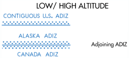

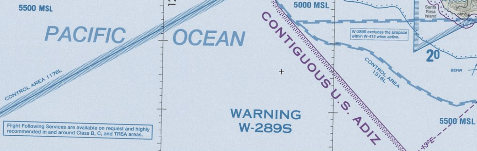
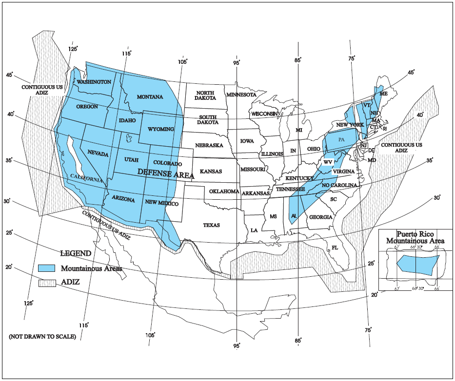
Special Air Traffic Rules (SATR) and Special Flight Rules Area (SFRA)
- The Code of Federal Regulations (CFR) prescribes special air traffic rules for aircraft operating within the boundaries of certain designated airspace
- These areas are listed in 14 CFR Part 93 and can be found throughout the NAS
- Procedures, nature of operations, configuration, size, and density of traffic vary among the identified areas
-
Special Flight Rules Area:
- Airspace of defined dimensions, above land areas or territorial waters, within which the flight of aircraft is subject to the rules set forth in 14 CFR Part 93, unless otherwise authorized by air traffic control
- Not all areas listed in 14 CFR Part 93 are designated SFRA, but special air traffic rules apply to all areas described in 14 CFR Part 93
- Reference: 14 CFR Part 93, Special Air Traffic Rules FAA Order JO 7110.65, Para 9-2-10, Special Air Traffic Rules (SATR) and Special Flight Rules Area (SFRA), PCG - Special Air Traffic Rules (SATR)
- Lists of these airspace may be viewed at: https://www.faa.gov/newsroom/restricted-airspace-0
-
SFRA Participation:
- Each person operating an aircraft to, from, or within airspace designated as a SATR area or SFRA must adhere to the special air traffic rules set forth in 14 CFR Part 93, as applicable, unless otherwise authorized or required by ATC
-
SFRA Charting:
- SFRAs are depicted on VFR sectional, terminal area, and helicopter route charts
-
Washington, DC, SFRA including the Flight Restricted Zone (FRZ):
- A pilot conducting any type of flight operation in the Washington, DC, SFRA/FRZ must comply with the requirements in:
- 14 CFR Section 93.339, Washington, DC, Metropolitan Area Special Flight Rules Area including the FRZ
- 14 CFR Section 91.161, Special Awareness Training for the DC SFRA/FRZ, also located on the FAA website at https://www.faasafety.gov/
- Any 14 CFR Section 99.7 special security instructions for the DC SFRA/FRZ published via NOTAM by FAA in the interest of national security
- A pilot conducting any type of flight operation in the Washington, DC, SFRA/FRZ must comply with the requirements in:
- Additional information and resources regarding SFRA, including procedures for flight in individual areas, may be found on the FAA Safety website at www.faasafety.gov
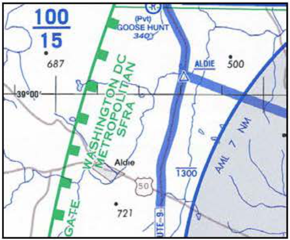
Weather Reconnaissance Area
- Hurricane Hunters from the United States Air Force Reserve 53rd Weather Reconnaissance Squadron (WRS) and the National Oceanic and Atmospheric Administration (NOAA) Aircraft Operations Center (AOC) operate weather reconnaissance/research aircraft missions, in support of the National Hurricane Operations Plan (NHOP), to gather meteorological data on hurricanes and tropical cyclones
- 53rd WRS and NOAA AOC aircraft normally conduct these missions in airspace identified in a published Weather Reconnaissance Area (WRA) Notice to Airmen (NOTAM)
- Airspace with defined dimensions and published by a NOTAM, which is established to support weather reconnaissance/research flights
- ATC services are not provided within WRAs
- Only participating weather reconnaissance/research aircraft from the 53rd WRS and NOAA AOC are permitted to operate within a WRA
- A WRA may only be established in airspace within U. S. Flight Information Regions (FIR) outside of U. S. territorial airspace
- A published WRA NOTAM describes the airspace dimensions of the WRA and the expected activities within the WRA
- WRAs may border adjacent foreign FIRs, but are wholly contained within U.S. FIRs
- As ATC services are not provided within a WRA, non-participating aircraft should avoid WRAs, and IFR aircraft should expect to be rerouted to avoid WRAs
Aircraft Hazard Area
- An airspace hazard area, or AHA, is used by air traffic control to segregate air traffic from a launch vehicle, reentry vehicle, amateur rocket, jettisoned stages, hardware, or falling debris generated by failures associated with any of these activities
- An AHA is designated via NOTAM as either a TFR or stationary altitude reservation (ALTRV)
- Unless otherwise specified, the vertical limits of an AHA are from the surface to unlimited
- More than one AHA may be established (designated AHA A, AHA B, etc.) to refelct different stages of a launch
- Other terms associated with space activities include Contengency Hazard Areas (CHAs), Refined Hazard Areas (RHAs), and Transitional Hazard Areas (THAs)
- Pilots are most likely to see TFRs, though some services use the ALTRV designation
Stationary or Moving Altitude Reservation (ALTRV)
- Stationary or Moving Altitude Reservation (ALTRV). A Stationary or Moving ALTRV is announced via an airspace NOTAM issued by the Central Altitude Reservation Facility (CARF) or ARTCC. These announcements will appear in CARF and/or ARTCC NOTAMS. This airspace ensures that non-participating IFR aircraft remain separated from special activity. Non-participating VFR aircraft are permitted to fly through the area but should exercise vigilance
ATC Assigned Airspace
- ATC ASSIGNED AIRSPACE. Airspace of defined vertical/lateral limits, assigned by ATC, for the purpose of providing air traffic segregation between the specified activities being conducted within the assigned airspace and other IFR air traffic. ATCAA locations and scheduled activation information can be found on the FAA SUA website; a NOTAM will not be issued to announce the activation of this airspace
Other Airspace Lessons & Case Studies
- NTSB Identification: MIA01FA028B The National Transportation Safety Board determines the probable cause(s) of this accident to be: The failure of the F-16 flight lead pilot and F-16 accident pilot to maintain an adequate visual lookout while maneuvering. Factors contributing to the accident were: the F-16 flight lead pilot's decision to discontinue radar traffic advisory service, the F-16 flight lead pilot's failure to identify a position error in his aircraft's navigational system, the F-16 pilots subsequent inadvertent entry into class C airspace without establishing and maintaining required communications with air traffic control (ATC); and ATC's lack of awareness that there was more than one F-16 aircraft in the formation flight, which reduced the ATC controllers ability to detect and resolve the conflict that resulted in the collision
Other Airspace Knowledge Check


Other Airspace Conclusion
- Participation within TRSAs is voluntary on the part of the pilot
- When operating in wildlife and recreational areas, be mindful of bird hazards in addition to other aircraft
- It is not mandatory that pilots participate in the Airport Advisory programs
- Participation enhances safety for everyone operating around busy GA airports; therefore, everyone is encouraged to participate and provide feedback that will help improve the program
- Airport advisory service personnel maintains charts depicting runways, local taxi routes, intersection takeoff information, airport traffic patterns, and instrument approach procedures for the location(s) served
- MTR routes are depicted on IFR En Route Low Altitude Charts and VFR Sectional Charts, which are available for free download on the FAA website at https://www.faa.gov/air_traffic/flight_info/aeronav/digital_products
- National security depends largely on the deterrent effect of our airborne military forces
- To be proficient, the military services must train in a wide range of airborne tactics
- MTRs require maneuvers and speeds which occasionally make the see-and-avoid aspect of flight more difficult, requiring increased vigilance
- Nonparticipating aircraft are not prohibited from flying within an MTR; however, extreme vigilance should be exercised when conducting flight through or near these routes
- When requesting MTR information, pilots should contact a Flight Service Station (FSS) with their position, route of flight, and destination in order to reduce frequency congestion and permit the FSS specialist to identify the MTR which could be a factor
- If concerned with a particular route, pilots should contact FSS within 100 NM of that MTR to obtain current information or route usage in their vicinity
- Details contained in 14 CFR Part 105 and tabulated in the Chart Supplement U.S.
- Times of operation are local, and MSL altitudes are listed unless otherwise specified
- No person may make a parachute jump, and no pilot-in-command may allow a parachute jump to be made from that aircraft, in or into Class A, Class B, Class C, or Class D airspace without, or in violation of, the terms of an ATC authorization issued by the ATC facility having jurisdiction over the airspace (See 14 CFR Part 105)
- The Federal Aviation Regulations are explicit as to what operations are prohibited, restricted, or allowed in a temporary flight restrictions area
- Pilots are responsible to comply with 14 CFR Sections 91.137, 91.138, 91.141 and 91.143 when conducting flight in an area where a temporary flight restrictions area is in effect, and should check appropriate NOTAMs during flight planning in accordance with FAR 91.103.
- TFRs are published on the Federal Aviation Administration website at https://tfr.faa.gov/tfr2/list.html.
- To learn more about how Temporary Flight Restrictions are developed, read FAA Safety - Mission Possible.
- It is very important to remember that these suggested routes are not sterile of other traffic
- The entire Class B airspace, and the airspace underneath it, may be heavily congested with many different types of aircraft
- Pilots of aircraft entering the United States through an ADIZ are required to comply with the provisions of 14 CFR Sections 99.17 and 99.19
- Note that ADIZ locations and operating and flight plan requirements for civil aircraft operations are specified in 14 CFR Part 99
- Operators may submit requests for FAA/TSA airspace waivers at https://waivers.faa.gov by selecting "international" as the waiver type
- Information regarding FAA/TSA airspace waivers can be found at: https://www.tsa.gov/for-industry/general-aviation or can be obtained by contacting TSA at (571) 227-2071
- Pilots should exercise extreme caution when warned of the presence of wildlife on and in the vicinity of airports
- Collisions of landing and departing aircraft and animals on the runway are increasing and are not limited to rural airports
- These accidents have also occurred at several major airports. Pilots should exercise extreme caution when warned of the presence of wildlife on and in the vicinity of airports
- Never forget to check NOTAMS, more specifically, international NOTAMS
- And finally as always, don't forget to close any flight plan you open!
- Still looking for something? Continue searching:
Other Airspace References
- Federal Aviation Administration - Pilot/Controller Glossary.
- Advisory Circular (91-36) Visual Flight Rules (VFR) Flight Near Noise-Sensitive Areas.
- Aeronautical Information Manual (3-5-1) Airport Advisory/Information Services.
- Aeronautical Information Manual (3-5-2) Military Training Routes.
- Aeronautical Information Manual (3-5-4) Parachute Jump Aircraft Operations.
- Aeronautical Information Manual (3-5-5) Published VFR Routes.
- Aeronautical Information Manual (3-5-6) Terminal Radar Service Area (TSRA).
- Aeronautical Information Manual (3-5-7. Special Air Traffic Rules (SATR) and Special Flight Rules Area (SFRA).
- Aeronautical Information Manual (4-1-9) Traffic Advisory Practices at Airports Without Operating Control Towers.
- Aeronautical Information Manual (4-1-18) Terminal Radar Services for VFR Aircraft.
- Aeronautical Information Manual (5-6-9) FAA/TSA Airspace Waivers.
- Aeronautical Information Manual (7-5-6) Flights Over Charted U.S. Wildlife Refuges, Parks, and Forest Service Areas.
- AeroNav Products - Aeronautical Chart User's Guide.
- AOPA - Know Before You Go: Navigating Today's Airspace.
- Federal Aviation Administration Order (7400.9) Airspace Designations and Reporting Points.
- FAA - Bird/Other Wildlife Strike Report.
- Federal Aviation Regulations (91.15) Dropping Objects.
- JO 7400.2 (Appendix 9) Noise Policy for Management of Airspace Over Federally Managed Lands.
- Federal Aviation Administration Order (7400.9) Airspace Designations and Reporting Points.
- Federal Aviation Regulations (Part 71) Designation of Class A, B, C, D, and E Airspace Areas; Air Traffic Service Routes; And Reporting Points.
- Federal Aviation Regulations (Part 91) General Operating and Flight Rules.
- Federal Aviation Regulations (91.159) VFR Cruising Altitude or Flight Level.
- AeroNav Products - Aeronautical Chart User's Guide.
- Federal Aviation Administration Order (7400.10) Airport Advisory Services
- Federal Aviation Administration Order (7400.9) Airspace Designations and Reporting Points.
- Federal Aviation Administration - National Airspace Systems Resources (NASR).
- Federal Aviation Administration - Aeronautical Information Portal.
- Federal Aviation Administration Order (7400.10 Series) Special Use Airspace.
- Federal Aviation Administration Order (7400.9) Airspace Designations and Reporting Points.
- Federal Aviation Administration Order (7610.4) Special Military Options.
- Federal Aviation Regulations (91.117) Aircraft Speed.
- Federal Aviation Regulations (91.119) Minimum safe altitudes: General.
- Federal Aviation Regulations (91.185b) IFR operations: Two-way radio communications failure.
- Instrument Flying Handbook (1-2) Airspace Classification.
- National Geospatial-Intelligence Agency.
- Wikipedia - Military Training Routes.
- Federal Aviation Regulations (Part 105) Parachute Operations.
- Pilot Workshops - Avoiding Parachute Jumpers.
- FAA Order (JO 7210.946) Issuing TFRs.
- Federal Aviation Administration Order (7400.9) Airspace Designations and Reporting Points.
- Aeronautical Information Manual (5-6-1) National Security.
- Federal Aviation Administration Order (7400.9) Airspace Designations and Reporting Points.
- FAA Order (7400.8) Special Use Airspace.
- Federal Aviation Regulations (91.137) Temporary flight restrictions in the vicinity of disaster/hazard areas.
- Federal Aviation Regulations (91.138) Temporary flight restrictions in national disaster areas in the State of Hawaii.
- Federal Aviation Regulations (91.139) Emergency air traffic rules.
- Federal Aviation Regulations (91.141) Flight restrictions in the proximity of the Presidential and other parties.
- Federal Aviation Regulations (91.143) Flight limitation in the proximity of space flight operations.
- Federal Aviation Regulations (91.144) Temporary Restriction on flight operations during abnormally high barometric pressure conditions.
- Federal Aviation Regulations (91.145) Management of aircraft operations in the vicinity of aerial demonstrations and major sporting events.
- Federal Aviation Regulations (91.161) Special awareness training required for pilots flying under visual flight rules within a 60-nm radius of the Washington, DC VOR/DME.
- Instrument Flying Handbook (1-2) Airspace Classification.
- Federal Aviation Administration Order (7400.9) Airspace Designations and Reporting Points.
- Aeronautical Information Manual (5-6-15) ADIZ Boundaries and Designated Mountainous Areas.
- Entering, Exiting and Flying in United States Airspace.
- Federal Aviation Administration Order (7400.9) Airspace Designations and Reporting Points.
- Federal Aviation Regulations (99, Subpart B) Designated Air Defense Identification Zones.