Weather & Atmosphere
Weather is one of the most dynamic and influential factors affecting every flight. Understanding aviation weather and atmospheric processes helps pilots interpret forecasts, recognize hazardous conditions, and make informed go/no-go decisions.
Introduction to Weather & Atmosphere
- The National Oceanic and Atmospheric Administration assesses around 440 people die each year due to weather-related aviation accidents
- Regardless of your experience level, weather is likely to be a key factor in your decision-making process
- A pilot's ability to find and interpret weather is essential to make well-informed decisions
- Failure to recognize deteriorating weather conditions leads to a exceptionally high mishap and associated lethality rate
- Weather service to aviation is a joint effort between federal agencies, the military weather services, and other aviation-oriented groups and individuals
- The National Weather Service operates a network of radar sites for detecting coverage, intensity, and movement of precipitation
- FAA and DOD radar sites in the western sections of the country supplement the network
- Local warning radar sites augment the network by operating on an as-needed basis to support warning and forecast programs
- Think you've got a solid understanding of weather and atmosphere? Don't miss the weather and atmosphere quiz below and the topic summary
Federal Agencies
-
National Weather Service:
- Provides weather, water, and climate data, forecasts and warnings for the protection of life and property and enhancement of the national economy
-
The National Oceanic and Atmospheric Administration (NOAA):
- NOAA conducts research and gathers data about the global oceans, atmosphere, space, and the sun
- Most importantly to pilots, they maintain the Aviation Digital Data Service (ADDS) which makes text, digital and graphical forecasts, analyses, and observations of aviation-related weather variables available to the aviation community
-
Federal Aviation Administration:
- The FAA facilitates and oversees the various agencies which create pilot products and provide weather services

Aviation Oriented Groups and Individuals
-
- Leidos is contracted through the FAA to provide weather services, notably their operation of Flight Service Stations

National Weather Service Aviation Program
- Weather service to aviation is a joint effort of the National Oceanic and Atmospheric Administration (NOAA), the National Weather Service (NWS), the Federal Aviation Administration (FAA), Department of Defense, and various private sector aviation weather service providers. Requirements for all aviation weather products originate from the FAA, which is the Meteorological Authority for the U.S
- NWS meteorologists are assigned to all air route traffic control centers (ARTCC) as part of the Center Weather Service Units (CWSU) as well as the Air Traffic Control System Command Center (ATCSCC). These meteorologists provide specialized briefings as well as tailored forecasts to support the needs of the FAA and other users of the NAS
Aviation Products:
- The NWS maintains an extensive surface, upper air, and radar weather observing program; and a nationwide aviation weather forecasting service
- Airport observations (METAR and SPECI) supported by the NWS are provided by automated observing systems
- Terminal Aerodrome Forecasts (TAF) are prepared by 123 NWS Weather Forecast Offices (WFOs) for over 700 airports. These forecasts are valid for 24 or 30 hours and amended as required
- Inflight aviation advisories (for example, Significant Meteorological Information (SIGMETs) and Airmen's Meteorological Information (AIRMETs)) are issued by three NWS Meteorological Watch Offices (MWOs); the Aviation Weather Center (AWC) in Kansas City, MO, the Alaska Aviation Weather Unit (AAWU) in Anchorage, AK, and the Weather Service Forecast Office (WFO) in Honolulu, HI. The AWC, the AAWU, and WSFO Honolulu issue area forecasts for selected areas. In addition, NWS meteorologists assigned to most ARTCCs as part of the Center Weather Service Unit (CWSU) provide Center Weather Advisories (CWAs) and gather weather information to support the needs of the FAA and other users of the system
- Several NWS National Centers for Environmental Production (NCEP) provide aviation specific weather forecasts, or select public forecasts which are of interest to pilots and operators
- The Aviation Weather Center (AWC) displays a variety of domestic and international aviation forecast products over the Internet at aviationweather.gov
- The NCEP Central Operations (NCO) is responsible for the operation of many numerical weather prediction models, including those which produce the many wind and temperature aloft forecasts
- The Storm Prediction Center (SPC) issues tornado and severe weather watches along with other guidance forecasts
- The National Hurricane Center (NHC) issues forecasts on tropical weather systems (for example, hurricanes)
- The Space Weather Prediction Center (SWPC) provides alerts, watches, warnings and forecasts for space weather events (for example, solar storms) affecting or expected to affect Earth's environment
- The Weather Prediction Center (WPC) provides analysis and forecast products on a national scale including surface pressure and frontal analyses
- NOAA operates two Volcanic Ash Advisory Centers (VAAC) which issue forecasts of ash clouds following a volcanic eruption in their area of responsibility
- Details on the products provided by the above listed offices and centers is available in the Aviation Weather Handbook
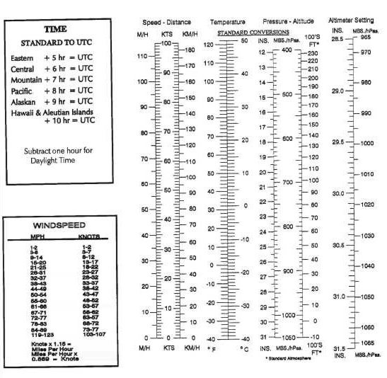
- Weather element values may be expressed by using different measurement systems depending on several factors, such as whether the weather products will be used by the general public, aviation interests, international services, or a combination of these users. [Figure 1] provides conversion tables for the most used weather elements that will be encountered by pilots
Use of Aviation Weather Products
- Air carriers and operators certificated under the provisions of 14 CFR Part 119 are required to use the aeronautical weather information systems defined in the Operations Specifications issued to that certificate holder by the FAA. These systems may utilize basic FAA/National Weather Service (NWS) weather services, contractor- or operator-proprietary weather services and/or Enhanced Weather Information System (EWINS) when approved in the Operations Specifications
- As an integral part of this system approval, the procedures for collecting, producing and disseminating aeronautical weather information, as well as the crew member and dispatcher training to support the use of system weather products, must be accepted or approved
- Operators not certificated under the provisions of 14 CFR Part 119 are encouraged to use FAA/NWS products through Flight Service Stations, and/or Flight Information Services-Broadcast (FIS-B)
- The suite of available aviation weather product types is expanding, with the development of new sensor systems, algorithms and forecast models
- The FAA and NWS, supported by various weather research laboratories and corporations under contract to the Government, develop and implement new aviation weather product types
- The FAA's NextGen Aviation Weather Research Program (AWRP) facilitates collaboration between the NWS, the FAA, and various industry and research representatives
- This collaboration ensures that user needs and technical readiness requirements are met before experimental products mature to operational application
- The AWRP manages the transfer of aviation weather R&D to operational use through technical review panels and conducting safety assessments to ensure that newly developed aviation weather products meet regulatory requirements and enhance safety
- The AWRP review and decision-making process applies criteria to weather products at various stages
- The stages are composed of the following:
- Sponsorship of user needs
- R & D and controlled testing
- Experimental application
- Operational application
- Pilots and operators should be aware that weather services provided by entities other than FAA, NWS or their contractors may not meet FAA/NWS quality control standards
- Hence, operators and pilots contemplating using such services should request and/or review an appropriate description of services and provider disclosure
- This should include, but is not limited to, the type of weather product (for example, current weather or forecast weather), the currency of the product (that is, product issue and valid times), and the relevance of the product
- Pilots and operators should be cautious when using unfamiliar products, or products not supported by FAA/NWS technical specifications
- When in doubt, consult with a FAA Flight Service Station Specialist
- In addition, pilots and operators should be aware there are weather services and products available from government organizations beyond the scope of the AWRP process mentioned earlier in this section
- For example, governmental agencies such as the NWS and the Aviation Weather Center (AWC), or research organizations such as the National Center for Atmospheric Research (NCAR) display weather "model data" and "experimental" products which require training and/or expertise to properly interpret and use
- These products are developmental prototypes that are subject to ongoing research and can change without notice
- Therefore, some data on display by government organizations, or government data on display by independent organizations may be unsuitable for flight planning purposes
- Operators and pilots contemplating using such services should request and/or review an appropriate description of services and provider disclosure
- This should include, but is not limited to, the type of weather product (for example, current weather or forecast weather), the currency of the product (i.e., product issue and valid times), and the relevance of the product
- Pilots and operators should be cautious when using unfamiliar weather products
- When in doubt, consult with a FAA Flight Service Station Specialist
- With increased access to weather products via the public Internet, the aviation community has access to an over whelming amount of weather information and data that support self-briefing
- Pilots and operators using the public Internet to access weather from a third party vendor should request and/or review an appropriate description of services and provider disclosure
- This should include, but is not limited to, the type of weather product (for example, current weather or forecast weather), the currency of the product (i.e., product issue and valid times), and the relevance of the product
- Pilots and operators should be cautious when using unfamiliar weather products
- When in doubt, consult with a FAA Flight Service Station Specialist
- The development of new weather products, coupled with the termination of some legacy textual and graphical products may create confusion between regulatory requirements and the new products
- All flight-related, aviation weather decisions must be based on all available pertinent weather products
- As every flight is unique and the weather conditions for that flight vary hour by hour, day to day, multiple weather products may be necessary to meet aviation weather regulatory requirements
- Many new weather products now have a Precautionary Use Statement that details the proper use or application of the specific product
-
Types of Aviation Weather Information:
- The FAA has identified three distinct types of weather information available to pilots and operators
-
Observations:
- Scheduled radar observations are taken hourly and transmitted in alpha-numeric format on weather telecommunications circuits for flight planning purposes. Under certain conditions, special radar reports are issued in addition to the hourly transmittals
- Data contained in the reports are also collected by the National Center for Environmental Prediction and used to prepare national radar summary charts for dissemination on facsimile circuits
- Raw weather data that is collected by some type of sensor suite including surface and airborne observations, radar, lightning, satellite imagery, and profilers
- Examples include:
- Scheduled radar observations are taken hourly and transmitted in alpha-numeric format on weather telecommunications circuits for flight planning purposes. Under certain conditions, special radar reports are issued in addition to the hourly transmittals
-
Analysis:
- Enhanced depiction and/or interpretation of observed weather data
- Examples include:
-
Forecasts:
- Predictions of the development and/or movement of weather phenomena based on meteorological observations and various mathematical models
- Examples include:
- Terminal Aerodrome Forecast (TAF)
- Meteorological Impact Statements (MIS)
- Prognostic Charts
- Convective Outlook
- Wind and Temperature Aloft (FB)
- Graphical Forecasts for Aviation (GFAs)
-
- The FAA has identified three distinct types of weather information available to pilots and operators
-
Official Weather Sources for Pilots:
- Not all sources of aviation weather information are able to provide all three types of weather information. The FAA has determined that operators and pilots may utilize the following approved sources of aviation weather information:
Federal Government:
- The FAA and NWS collect raw weather data, analyze the observations, and produce forecasts. The FAA and NWS disseminate meteorological observations, analyses, and forecasts through a variety of systems. In addition, the Federal Government is the only approval authority for sources of weather observations; for example, contract towers and airport operators may be approved by the Federal Government to provide weather observations
Enhanced Weather Information System (EWINS):
- An EWINS is an FAA authorized, proprietary system for tracking, evaluating, reporting, and forecasting the presence or lack of adverse weather phenomena. The FAA authorizes a certificate holder to use an EWINS to produce flight movement forecasts, adverse weather phenomena forecasts, and other meteorological advisories. For more detailed information regarding EWINS, see the Federal Aviation Administration (FAA-H-8083-28) Aviation Weather Handbook and the Flight Standards Information Management System 8900.1
Commercial Weather Information Providers:
- In general, commercial providers produce proprietary weather products based on NWS/FAA products with formatting and layout modifications but no material changes to the weather information itself. This is also referred to as "repackaging." In addition, commercial providers may produce analyses, forecasts, and other proprietary weather products that substantially alter the information contained in government-produced products. However, those proprietary weather products that substantially alter government- produced weather products or information, may only be approved for use by 14 CFR Part 121 and Part 135 certificate holders if the commercial provider is EWINS qualified
- Commercial weather information providers contracted by FAA to provide weather observations, analyses, and forecasts (e.g., contract towers) are included in the Federal Government category of approved sources by virtue of maintaining required technical and quality assurance standards under Federal Government oversight
- In general, commercial providers produce proprietary weather products based on NWS/FAA products with formatting and layout modifications but no material changes to the weather information itself. This is also referred to as "repackaging." In addition, commercial providers may produce analyses, forecasts, and other proprietary weather products that substantially alter the information contained in government-produced products. However, those proprietary weather products that substantially alter government- produced weather products or information, may only be approved for use by 14 CFR Part 121 and Part 135 certificate holders if the commercial provider is EWINS qualified
- Not all sources of aviation weather information are able to provide all three types of weather information. The FAA has determined that operators and pilots may utilize the following approved sources of aviation weather information:
- As a point of clarification, Advisory Circular 00-62, Internet Communications of Aviation Weather and NOTAMS, describes the process for a weather information provider to become a Qualified Internet Communications Provider (QICP) and only applies to 14 CFR Part 121 and Part 135 certificate holders. Therefore, pilots conducting operations under 14 CFR Part 91 may access weather products via the public Internet
Making Operational Decisions
- The three basic elements of weather are:
- Temperature (warm or cold)
- Wind (a vector with speed and direction)
- Moisture (or humidity)
- Temperature, wind, and moisture combine to varying degrees to create conditions that affect pilots. The range of possible combinations is nearly infinite, but weather primarily affects pilots in three ways:
- Visibility
- Turbulence
- Effects on Aircraft Performance
Graphical Forecasts for Aviation
- The Graphical Forecasts for Aviation (GFA) website is intended to provide the necessary aviation weather information to give users a complete picture of the weather that may affect flight in the continental United States (CONUS). The website includes observational data, forecasts, and warnings that can be viewed from 14 hours in the past to 15 hours in the future, including thunderstorms, clouds, flight category, precipitation, icing, turbulence, and wind. Hourly model data and forecasts, including information on clouds, flight category, precipitation, icing, turbulence, wind, and graphical output from the National Weather Service's (NWS) National Digital Forecast Data (NDFD) are available. Wind, icing, and turbulence forecasts are available in 3,000 ft increments from the surface up to 30,000 ft MSL, and in 6,000 ft increments from 30,000 ft MSL to 48,000 ft MSL. Turbulence forecasts are also broken into low (below 18,000 ft MSL) and high (at or above 18,000 ft MSL) graphics. A maximum icing graphic and maximum wind velocity graphic (regardless of altitude) are also available. Built with modern geospatial information tools, users can pan and zoom to focus on areas of greatest interest. Target users are commercial and general aviation pilots, operators, briefers, and dispatchers
- Weather Products:
- The Aviation Forecasts include gridded displays of various weather parameters as well as NWS textual weather observations, forecasts, and warnings. Icing, turbulence, and wind gridded products are three-dimensional. Other gridded products are two-dimensional and may represent a "composite" of a three-dimensional weather phenomenon or a surface weather variable, such as horizontal visibility. The following are examples of aviation forecasts depicted on the GFA:
- Terminal Aerodrome Forecast (TAF)
- Ceiling & Visibility (CIG/VIS)
- Clouds
- Precipitation / Weather (PCPN/WX)
- Thunderstorm (TS)
- Winds
- Turbulence
- Ice
- Observations & Warnings (Obs/Warn):
- The Obs/Warn option provides an option to display weather data for the current time and the previous 14 hours (rounded to the nearest hour). Users may advance through time using the arrow buttons or by clicking on the desired hour. Provided below are the Obs/Warn product tabs available on the GFA website:
- METAR
- Precipitation/Weather (PCPN/WX)
- Ceiling & Visibility (CIG/VIS)
- Pilot Reports (PIREP)
- Radar & Satellite (RAD/SAT)
- The Obs/Warn option provides an option to display weather data for the current time and the previous 14 hours (rounded to the nearest hour). Users may advance through time using the arrow buttons or by clicking on the desired hour. Provided below are the Obs/Warn product tabs available on the GFA website:
- The GFA will be continuously updated and available online at https://aviationweather.gov/gfa. Upon clicking the link above, select INFO on the top right corner of the map display. The next screen presents the option of selecting Overview, Products, and Tutorial. Simply select the tab of interest to explore the enhanced digital and graphical weather products designed to replace the legacy FA. Users should also refer to FAA−H−8083−28, Aviation Weather Handbook, for more detailed information on the GFA
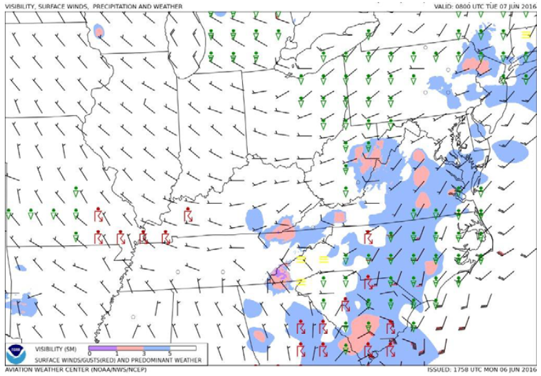
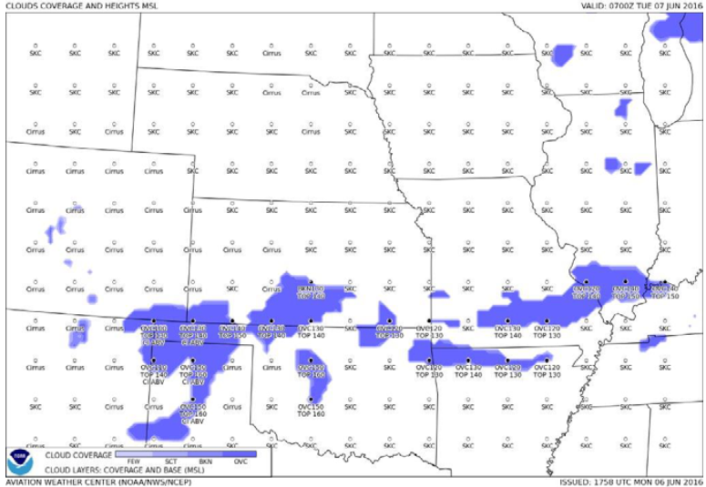
- GFA Static Images. Some users with limited internet connectivity may access static images via the Aviation Weather Center (AWC) at: https://www.aviationweather.gov/gfa/plot. There are two static graphical images available, titled Aviation Cloud Forecast and Aviation Surface Forecast. The Aviation Cloud Forecast provides cloud coverage, bases, layers, and tops with AIRMETs for mountain obscuration and AIRMETs for icing overlaid. The Aviation Surface Forecast provides visibility, weather phenomena, and winds (including wind gusts) with AIRMETs for instrument flight rules conditions and AIRMETs for sustained surface winds of 30 knots or more overlaid. These images are presented on ten separate maps providing forecast views for the entire contiguous United States (U.S.) on one and nine regional views which provide more detail for the user. They are updated every 3 hours and provide forecast snapshots for 3, 6, 9, 12, 15, and 18 hours into the future [Figure 3/4]
- The contiguous United States (U.S.) refers to the 48 adjoining U.S. states on the continent of North America that are south of Canada and north of Mexico, plus the District of Columbia. The term excludes the states of Alaska and Hawaii, and all off-shore U.S. territories and possessions, such as Puerto Rico
- The Aviation Forecasts include gridded displays of various weather parameters as well as NWS textual weather observations, forecasts, and warnings. Icing, turbulence, and wind gridded products are three-dimensional. Other gridded products are two-dimensional and may represent a "composite" of a three-dimensional weather phenomenon or a surface weather variable, such as horizontal visibility. The following are examples of aviation forecasts depicted on the GFA:
Weather
- The Atmosphere is a dynamic interaction of temperatures and pressures which drive the characteristics of air masses
- These air masses move and interact, creating fronts, that drive the weather with which pilots must contend
- These phenomena consist of clouds, fog, and thunderstorms
- While all weather conditions create hazards to pilots, some such as Microbursts and aircraft icing can be especially hazardous
- It is therefore important that pilots prepare, receive preflight briefings, and take advantage of various weather services
- Additionally, Solar, Lunar, Almanac Prediction (SLAP) data allows prediction for known lighting and sun angles with which to consider
- ERAU Weather Information Sheet
- Low-Level Wind Shear & Microburst Detection Systems
- Terminal Broadcast Services and Systems
- W.M.O. Present Weather Code List
- ATC In-Flight Weather Avoidance Assistance
Categorical Outlooks
- Categorical outlook terms, describing general ceiling and visibility conditions for advanced planning purposes are used only in area forecasts and are defined as follows:
- LIFR (Low IFR). Ceiling less than 500 feet and/or visibility less than 1 mile
- IFR. Ceiling 500 to less than 1,000 feet and/or visibility 1 to less than 3 miles
- MVFR (Marginal VFR). Ceiling 1,000 to 3,000 feet and/or visibility 3 to 5 miles inclusive
- VFR. Ceiling greater than 3,000 feet and visibility greater than 5 miles; includes sky clear
- The cause of LIFR, IFR, or MVFR is indicated by either ceiling or visibility restrictions or both. The contraction "CIG" and/or weather and obstruction to vision symbols are used. If winds or gusts of 25 knots or greater are forecast for the outlook period, the word "WIND" is also included for all categories including VFR
- Examples:
- LIFR CIG-low IFR due to low ceiling
- IFR FG-IFR due to visibility restricted by fog
- MVFR CIG HZ FU-marginal VFR due to both ceiling and visibility restricted by haze and smoke
- IFR CIG RA WIND-IFR due to both low ceiling and visibility restricted by rain; wind expected to be 25 knots or greater
Precipitation
- Rain, snow, sleet, hail, etc. that fall from the clouds, are forms of precipitation
- Precipitation, such as rain, is friction
- Like boats in water (picture how fast a jet ski stops when throttle is released), precipitation will have an effect on an aircraft
- Heavy precipitation can slow an airplane in cruise and even slow propeller revolutions making altitude and airspeed a challenge to maintain
Weathercams
- The FAA Weather Camera Program in collaboration with State Departments of Transportation (DOT) host weather camera systems in the lower 48 states and lays the path for other state DOTs to implement the service for their aviation communities
- The camera images are publicly available on a new website https://weathercams.faa.gov with tutorials on how to use the information presented on the site
Weather Resources
- To learn more, consider AOPA's IFR Insights Cockpit Weather interactive course
-
Graphical Forecasts for Aviation Tool:
- The Graphical Forecasts for Aviation Tool (GFA) Tool is a set of web-based displays intended to provide the necessary aviation weather information to give users a complete picture of the weather that may impact their flight operations.
- It is a one-stop shop for multiple data fields.
- The AWC website includes observational data, forecasts, and advisories including thunderstorms, clouds, flight category, precipitation, icing, turbulence, and wind.
- Hourly model data and forecasts, including information on clouds, flight category, precipitation, icing, turbulence, wind, and graphical output from the NWS' NDFD, are available.
- Built with modern geospatial information tools, users can pan and zoom to focus on areas of greatest interest. [Figure 5]
- Descriptions of the observations, forecasts, and advisories that are used in the GFA Tool have been presented in other chapters within this handbook.
- This section does not show or describe the many possible overlays for the GFA Tool, since the AWC has produced a very thorough and complete description under the "Info" tab on the AWC's GFA Tool website, which also includes a tutorial video.
- In addition, the GFA Tool will continue to be enhanced; therefore, users will be assured of being informed of the latest GFA Tool information by referring to the "Info" tab on AWC's GFA Tool website.
- Caution should be applied as users configure the GFA Tool for use. Users can turn on and turn off certain functions (e.g., AIRMET and SIGMET overlays for a given geographical area).
- This can lead to hidden areas of hazardous weather for a given flightpath.
- Currently, the GFA Tool covers the CONUS, the Gulf of Mexico, the Caribbean, portions of the Atlantic Ocean, and portions of the Pacific Ocean, including the Hawaiian Islands and Alaska.
- The experimental GFA Tool became available for Alaska in December 2020 and transitioned into operational status in February 2022.

Weather Information
- The NWS/NOAA provides weather products via the Aviation Weather Center
- weather.gov/aawu
- wpc.ncep.noaa.gov
- nhc.noaa.gov
- spc.noaa.gov
- ssd.noaa.gov/vaac/vaac.html
- Aviation Routine Weather Reports (METARs)
- Prognostic Charts
- The FAA provides radar services to pilots to connect them with air traffic control and their weather resources
- The FAA further provides weather services, including:
- Flight Information Services
- 1800wxbrief.com
- Aviation Cameras
- fly.faa.gov/flyfaa/usmap.jsp
- notams.aim.faa.gov/notamSearch
- Contract service via flight service stations provide access to ground-based weather and flight planning resources
- It is important to recognize the delays associated with each weather source, as some data may be hours hold
Inflight Weather Resources
- Pilots have increase access to real-time weather resources inflight through avionics and subscription services, but with more information comes the requirement to interpret and isolate noise
- Weather information is not just a matter of preflight prepatation, but inflight monitoring to improve aeronautical decision-making
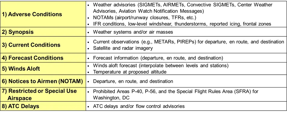
- Pilots are encouraged to use the same list of elements for their preflight self-briefing that a FSS uses for a standard weather briefing
- This list assists pilots in complying with 14 CFR section 91.103, regardless of the automated weather resource they use to gather the information [Figure 6]
- FIS-B information is available to UAT-equipped aircraft only
- The system broadcasts aeronautical information products from the FAA and weather products from the National Weather Service
Weather and Atmosphere Knowledge Quiz
Weather & Atmosphere Conclusion
- Flying an airplane during ideal conditions carry its own set of challenges
- It is therefore important that pilots invest time into learning about weather and how it can impact them in their operations
- Read more about National Weather Service website
- For more information, a paper copy of Federal Aviation Administration (FAA-H-8083-28) Aviation Weather Handbook [Amazon] is available for purchase
- A digital copy of Federal Aviation Administration (FAA-H-8083-28) Aviation Weather Handbook is available from the FAA's website
- Weather products like windy.com offer additional insight into aviation weather forecasts and observations
- Note that pilots, including students may fly in the rain provided visibility and ceiling requirements are met
- While many will prefer internet enabled devices, the Pilot Operating Handbook provides conversion charts for when internet is unavailable.
- Future weather efforts are underway with projects like the FAA's Weather Technology in the Cockpit
- Improve your weather skills with FAA provided (and WINGS credited) resources by going to https://www.faasafety.gov/ and type "weather" into the search bar
- Still looking for something? Continue searching:
Weather & Atmosphere References
- Federal Aviation Administration (FAA-H-8083-28) Aviation Weather Handbook
- Federal Aviation Administration - Pilot/Controller Glossary
- Aeronautical Information Manual (7-1-1) National Weather Service Aviation Weather Service Program
- Aeronautical Information Manual (7-1-3) Use of Aviation Weather Products
- FAA (FAA-H-8083-23) Aviation Weather Handbook
- Federal Aviation Administration - Weathercams
- Pilot Workshops - Outlooks, Watches, and Warnings