In Flight Weather Advisories
In-flight weather advisories are forecasts that advise en-route aircraft of the development of potentially hazardous weather.
Introduction to In Flight Weather Advisories
- Inflight Aviation Weather Advisories are forecasts to advise en route aircraft of development of potentially hazardous weather
- Issued by numerous sources with varying times of validity, inflight aviation weather advisories guide decisions during preflight, and inflight planning
- Four types of inflight aviation weather advisories exist:
- Additionally, the Severe Weather Watch Bulletins (WWs), (with associated Alert Messages) (AWW) supplements these Inflight Aviation Weather Advisories.
- All of these advisories use VORs, airports, or well-known geographic areas to describe the hazardous weather areas
In Flight Weather Advisories Key Highlights
- In-flight weather advisories alert pilots to hazardous weather conditions that may affect aircraft safety and operational decision-making.
- Common aviation weather advisories include AIRMETs, SIGMETs, Convective SIGMETs, Center Weather Advisories, and pilot reports.
- AIRMETs identify widespread moderate hazards such as icing, turbulence, mountain obscuration, and IFR conditions.
- SIGMETs warn of significant non-convective hazards such as severe icing, severe turbulence, dust storms, sandstorms, and volcanic ash.
- Convective SIGMETs warn pilots of thunderstorms, embedded convection, hail, tornadoes, and intense convective weather activity.
- Center Weather Advisories provide short-term weather hazard information issued by Air Route Traffic Control Centers.
- Pilots should compare advisories with route, altitude, aircraft capability, fuel planning, and alternate airport options.
- Weather advisories may change rapidly, requiring pilots to obtain updates before departure and during flight when practical.
- Air traffic control, Flight Service, Electronic Flight Bags, and datalink systems can help pilots access current advisory information.
- Understanding in-flight weather advisories improves hazard recognition, route planning, and overall flight safety.
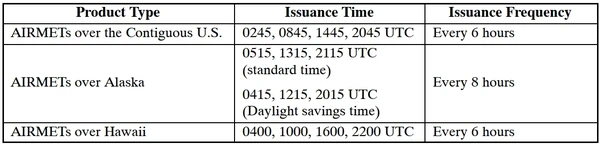
Inflight Weather Advisories Issuance
- Inflight aviation advisories (for example, Significant Meteorological Information (SIGMETs) and Airmen's Meteorological Information (AIRMETs)) are issued by three NWS Meteorological Watch Offices (MWOs); the Aviation Weather Center (AWC) in Kansas City, MO, the Alaska Aviation Weather Unit (AAWU) in Anchorage, AK, and the Weather Service Forecast Office (WFO) in Honolulu, HI. The AWC, the AAWU, and WSFO Honolulu issue area forecasts for selected areas. In addition, NWS meteorologists assigned to most ARTCCs as part of the Center Weather Service Unit (CWSU) provide Center Weather Advisories (CWAs) and gather weather information to support the needs of the FAA and other users of the system. []
- Inflight aviation weather advisories are issued based on specific criteria (discussed below)
- Inflight aviation weather advisories in the conterminous U.S. are issued by several different sources:
- The Aviation Weather Center (AWC) in Kansas City, Missouri, as well as 20 Center Weather Service Units (CWSU) associated with ARTCCs.
- AWC also issues advisories for portions of the Gulf of Mexico, Atlantic and Pacific Oceans, which are under the control of ARTCCs with Oceanic flight information regions (FIRs).
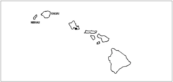
- The Weather Forecast Office (WFO) in Honolulu issues advisories for the Hawaiian Islands and a large portion of the Pacific Ocean.
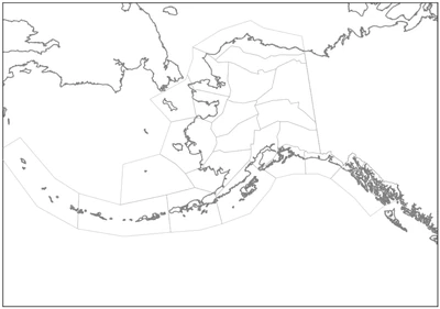
- In Alaska, the Alaska Aviation Weather Unit (AAWU) issues inflight aviation weather advisories along with the Anchorage CWSU.
- All heights are referenced MSL, except in the case of ceilings (listed as "CIG") which indicates AGL.
- The Aviation Weather Center (AWC) in Kansas City, Missouri, as well as 20 Center Weather Service Units (CWSU) associated with ARTCCs.

Inflight Weather Advisories Validity
- Validity will vary depending on the type of inflight weather advisory: []
- AIRMET are valid for a maximum of 6 hours.
- Alaska AIRMETs are valid for up to 8 hours.
- SIGMETs are valid for a maximum of 4 hours.
- Tropical Cyclones and Volcanic Ash Cloud SIGMETs are valid for up to 6 hours.
- Convective SIGMETs are valid for a maximum of 2 hours.
- AIRMET are valid for a maximum of 6 hours.
- In all instances, unscheduled updates and corrections are issued as necessary
Airman Meteorological Information
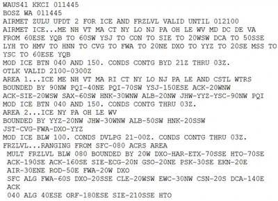
- AIRman's METeorological products are a concise description of the occurrence or expected occurrence of specified en route weather phenomena that may affect the safety of aircraft operations, but at intensities lower than those which require the issuance of a SIGMET [//]
- AIRMETs contain details about IFR conditions, extensive mountain obscuration, turbulence, strong surface winds, icing, and freezing levels. Unscheduled updates and corrections are issued as necessary
- AIRMETs Are:
- Intended to inform all pilots, but especially Visual Flight Rules pilots and operators of sensitive aircraft, of potentially hazardous weather phenomena.
- Issued on a scheduled basis every 6 hours, except every 8 hours in Alaska.
- Unscheduled updates and corrections are issued as necessary.
- intended for dissemination to all pilots in the preflight and en route phase of flight to enhance safety. En route AIRMETs are available over flight service frequencies. Over the contiguous U.S., AIRMETs are also available on equipment intended to display weather and other non-air traffic control-related flight information to pilots using the Flight Information Service–Broadcast (FIS-B). In Alaska and Hawaii, AIRMETs are broadcast on air traffic frequencies.
- issued for the contiguous U.S., Alaska, and Hawaii. No AIRMETs are issued for U.S. Oceanic FIRs in the Gulf of Mexico, Caribbean, Western Atlantic, and Pacific Oceans.
-
AIRMETs over the Contiguous U.S.:
- Are displayed graphically on websites, such as, aviationweather.gov and 1800wxbrief.com, and equipment receiving FIS-B information.
- Provide a higher forecast resolution than AIRMETs issued in text format.
- Are valid at discrete times no more than 3 hours apart for a period of up to 12 hours into the future (for example, 00, 03, 06, 09, and 12 hours). Additional forecasts may be inserted during the first 6 hours (for example; 01, 02, 04, and 05). 00-hour represents the initial conditions, and the subsequent graphics depict the area affected by the particular hazard at that valid time. Forecasts valid at 00 through 06 hours correspond to the text AIRMET bulletin.
- Depict the following en route aviation weather hazards:
- Instrument flight rule conditions (ceiling less than 1000' and/or surface visibility less than 3 miles).
- Widespread mountain obscuration.
- Moderate icing.
- Freezing levels.
- Moderate turbulence.
- Non-convective low-level wind shear potential below 2,000 feet AGL.
- Sustained surface winds greater than 30 knots.
- Interpolation of time periods between AIRMETs over the contiguous U.S. valid times: Users must keep in mind when using the AIRMET over the contiguous U.S. that if a 00-hour forecast shows no significant weather and a 03-hour forecast shows hazardous weather, they must assume a change is occurring during the period between the two forecasts. It should be taken into consideration that the hazardous weather starts immediately after the 00-hour forecast unless there is a defined initiation or ending time for the hazardous weather. The same would apply after the 03-hour forecast. The user should assume the hazardous weather condition is occurring between the snap shots unless informed otherwise. For example, if a 00-hour forecast shows no hazard, a 03-hour forecast shows the presence of hazardous weather, and a 06-hour forecast shows no hazard, the user should assume the hazard exists from the 0001 hour to the 0559 hour time period
-
AIRMETs over Alaska and Hawaii:
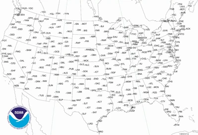
- AIRMETs over Alaska and Hawaii are in text format. The hazard areas are described using well-known geographical areas. AIRMETs over Alaska are issued for three Alaskan regions corresponding to Alaska area forecasts (See FIG 7-1-4).
- AIRMETs over Alaska are valid up to eight hours. AIRMETs over Hawaii are valid up to six hours. Unscheduled issuances contain an update number for easier identification.
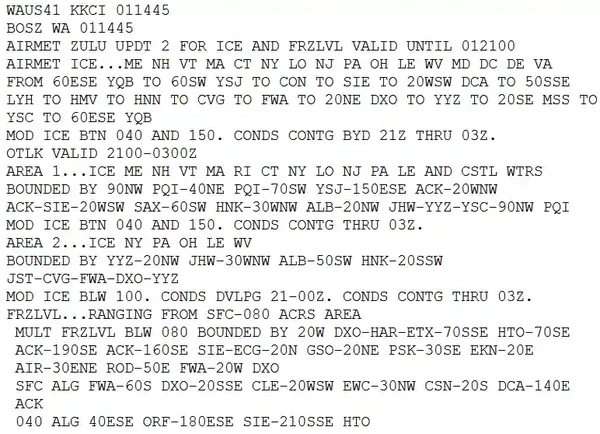
- AIRMET Zulu describes moderate icing and provides freezing level heights.
- Considered to be widespread because they must be affecting or be forecast to affect an area of at least 3000 square miles at any one time
- However, if the total area to be affected during the forecast period is very large, it could be that in actuality only a small portion of this total area would be affected at any one time
- These reports do not take into account terrain such as mountains or bodies of water which could impact the forecasted weather
- AIRMETs (WAs) are advisories of significant weather phenomena but describe conditions at intensities lower than those which require the issuance of SIGMETs
- AIRMETs are intended for dissemination to all pilots in the preflight and en route phase of flight to enhance safety
- AIRMET information are issued in two formats:
- A textual bulletin (WA), or
- Graphical report (G-AIRMET)
-
Text AIRMET (WA):
- AIRMET text (WA) products are issued corresponding to the Area Forecast (FA) areas described in , 4 & 5]
- Considered to be widespread because they must be affecting or be forecast to affect an area of at least 3,000 square miles at any one time
- However, if the total area to be affected during the forecast period is very large, it could be that in actuality only a small portion of this total area would be affected at any one time
- AIRMETs (text) are issued every 6 hours, beginning at 0245 UTC with Graphical AIRMETs issued on schedule
- After the first issuance each day, scheduled or unscheduled bulletins are numbered sequentially for easier identification
There are three types AIRMETs:
-
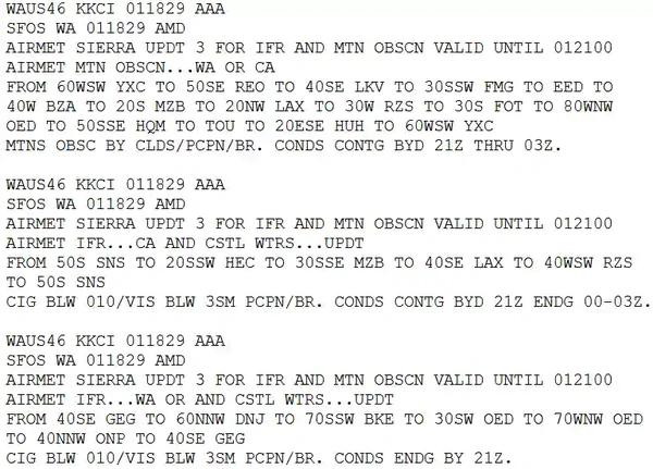
AIRMET Sierra:
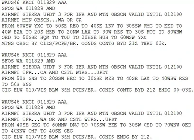
- AIRMET Sierra describes IFR conditions and/or extensive mountain obscuration. []
- For operations under Instrument Flight Rules (IFR)
- Ceilings less than 1000' and/or visibility less than 3 miles affecting over 50% of an area at one time
-
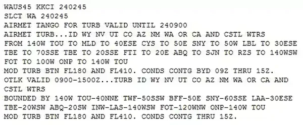
AIRMET Tango:
- AIRMET Tango describes moderate turbulence, sustained surface winds of 30 knots or greater, and/or non-convective low-level wind shear. []
-
AIRMET Zulu:
- AIRMET Zulu describes moderate icing and provides freezing level heights. []
-
-
Graphical AIRMETs (G-AIRMETs):
- Graphical AIRMETs (G-AIRMETs) are graphical forecasts of en-route weather hazards valid at discrete times no more than 3 hours apart for a period of up to 12 hours into the future
- Example: 00, 03, 06, 09, and 12 hours
- Additional forecasts may be inserted during the first 6 hours
- Example: 01, 02, 04, and 05
- 00 hour represents the initial conditions, and the subsequent graphics depict the area affected by the particular hazard at that valid time
- Forecasts valid at 00 through 06 hours correspond to the text AIRMET bulletin
- Forecasts valid at 06 through 12 hours correspond to the text bulletin outlook
- G-AIRMET depicts the following en route aviation weather hazards:
- Instrument flight rule conditions (ceiling greater than 1000' and/or surface visibility greater than 3 miles)
- Mountain obscuration
- Icing
- Freezing level
- Turbulence
- Low level wind shear (LLWS)
- Strong surface winds
- G-AIRMETs are snap shots at discrete time intervals as defined above
- The text AIRMET is the result of the production of the G-AIRMET, but provided in a time smear for a 6 hr valid period
- G-AIRMETs provide a higher forecast resolution than text AIRMET products
- Since G-AIRMETs and text AIRMETs are created from the same forecast "production" process, there exists perfect consistency between the two
- Using the two together will provide clarity of the area impacted by the weather hazard and improve situational awareness and decision-making
- Interpolation of time periods between G-AIRMET valid times:
- Users must keep in mind when using the G-AIRMET, that if a 00 hour forecast shows no significant weather and a 03 hour forecast shows hazardous weather, they must assume a change is occurring during the period between the two forecasts
- It should be taken into consideration that the hazardous weather starts immediately after the 00 hour forecast, unless there is a defined initiation or ending time for the hazardous weather
- The same would apply after the 03 hour forecast
- The user should assume the hazardous weather condition is occurring between the snap shots, unless informed otherwise
- Example: if a 00 hour forecast shows no hazard, a 03 hour forecast shows the presence of hazardous weather, and a 06 hour forecast shows no hazard, the user should assume the hazard exists from the 0001 hour to the 0559 hour time period
- Graphical AIRMETs (G-AIRMETs) are graphical forecasts of en-route weather hazards valid at discrete times no more than 3 hours apart for a period of up to 12 hours into the future
Significant Meteorological Information
- SIGnificant METeorological information are a concise description of the occurrence or expected occurrence of specified en route weather phenomena which is expected to affect the safety of aircraft operations shown in [, 6 & 7]
- SIGMETs are:
- Intended for dissemination to all pilots in flight to enhance safety.
- Issued by the responsible MWO as soon as it is practical to alert operators and aircrews of hazardous en route conditions.
- Unscheduled products that are valid for 4 hours; except SIGMETs associated with tropical cyclones and volcanic ash clouds are valid for 6 hours.
- Unscheduled updates and corrections are issued as necessary.
- Use geographical points to describe the hazardous weather areas.
- These points can reference either VORs, airports, or latitude-longitude, depending on SIGMET location.
- If the total area to be affected during the forecast period is very large, it could be that, in actuality, only a small portion of this total area would be affected at any one time.
- Example of a SIGMET:
- BOSR WS 050600
- SIGMET ROMEO 2 VALID UNTIL 051000
- ME NH VT
- FROM CAR TO YSJ TO CON TO MPV TO CAR MOD TO OCNL SEV TURB BLW 080 EXP DUE TO STG NWLY FLOW. CONDS CONTG BYD 1000Z
-
SIGMETs over the contiguous U.S.:
- Are issued corresponding to the areas and are only for non-convective weather. []
- The U.S. issues a special category of SIGMETs for convective weather called Convective SIGMETs.
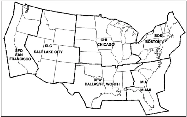
- Are identified by an alphabetic designator from November through Yankee, excluding Sierra and Tango. Issuance for the same phenomenon will be sequentially numbered, using the original designator until the phenomenon ends. For example, the first issuance in the Chicago (CHI) area (reference FIG 7-1-5) for phenomenon moving from the Salt Lake City (SLC) area will be SIGMET Papa 3, if the previous two issuances, Papa 1 and Papa 2, had been in the SLC area. Note that no two different phenomena across the country can have the same alphabetic designator at the same time.
- Use location identifiers (either VORs or airports) to describe the hazardous weather areas.
- Are issued when the following phenomena occur or are expected to occur:
- Severe icing not associated with thunderstorms.
- Severe or extreme turbulence or clear air turbulence (CAT) not associated with thunderstorms.
- Widespread dust storms or sandstorms lowering surface visibilities to below 3 miles.
- Volcanic ash.
-
SIGMETs over Alaska:
- Are issued for the Anchorage FIR including Alaska and nearby coastal waters corresponding to the areas. []
- Alaksa SIGMENTs are only for non-convective weather.
- The U.S. issues a special category of SIGMETs for convective weather called Convective SIGMETs.
- Use location identifiers (either VORs or airports) to describe the hazardous weather areas.
- Use points of latitude and longitude over the ocean areas of the Alaska FIR.
- Are identified by an alphabetic designator from India through Mike.
- In addition to the phenomenon applicable to SIGMETs over the contiguous U.S., SIGMETs over Alaska are also issued for:
- Tornadoes.
- Lines of thunderstorms.
- Embedded thunderstorms.
- Hail greater than or equal to 3/4 inch in diameter
-
SIGMETs Over Oceanic Regions:
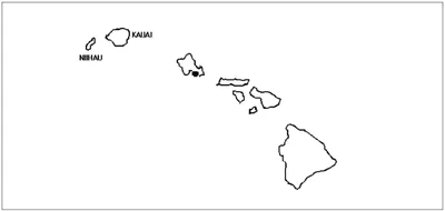
- SIGMETs over oceanic regions (New York Oceanic FIR, Oakland Oceanic FIR including Hawaii, Houston Oceanic FIR, Miami Oceanic FIR, San Juan FIR), points of latitude and longitude are used to describe the hazard area: []
- SIGMETs over the Oakland Oceanic FIR west of 140 west and south of 30 north (including the Hawaiian Islands) are identified by an alphabetic designator from November through Zulu.
- SIGMETs over the Oakland Oceanic FIR east of 140 west and north of 30 north are identified by an alphabetic designator from Alpha through Mike.
- SIGMETs over the New York Oceanic FIR, Houston Oceanic FIR, Miami Oceanic FIR, and San Juan FIR are identified by an alphabetic designator from Alpha through Mike.
- In addition to SIGMETs issued for the phenomenon for the contiguous U.S., SIGMETs in the oceanic regions are also issued for:
- Tornadoes.
- Lines of thunderstorms.
- Embedded thunderstorms.
- Hail greater than or equal to 3/4 inch in diameter
- SIGMETs over oceanic regions (New York Oceanic FIR, Oakland Oceanic FIR including Hawaii, Houston Oceanic FIR, Miami Oceanic FIR, San Juan FIR), points of latitude and longitude are used to describe the hazard area: []


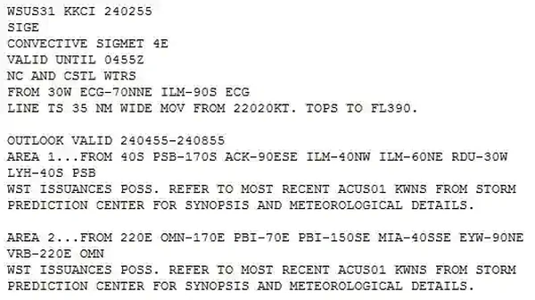
Convective SIGMETs
- Convective SIGMETS (also known internationally as SIGMET for Convection) are text/graphical reports are issued for the contiguous U.S. []
- Convective SIGMETs are issued in the conterminous U.S. for any of the following:
- Severe thunderstorms due to:
- Surface winds greater than or equal to 50 knots.
- Hail at the surface greater than or equal to 3/4 inches in diameter
- Tornadoes.
- Embedded Thunderstorms.
- A line of thunderstorms.
- Thunderstorms producing precipitation greater than or equal to heavy precipitation affecting 40% or more of an area at least 3,000 square miles.
- Severe thunderstorms due to:
- Any convective SIGMET implies severe or greater turbulence, severe icing, and low-level wind shear issued for any convective situation that the forecaster feels is hazardous to all categories of aircraft.
- Convective SIGMET bulletins are issued for the western (W), center (C), and eastern (E) United States.
- Convective SIGMETs are not issued for Alaska or Hawaii.
- The areas are separated at 87° and 107° west longitude with sufficient overlap to cover most cases when the phenomenon crosses the boundaries
- If no criteria meeting convective SIGMET requirements are observed or forecasted, the message "CONVECTIVE SIGMET...NONE" will be issued at H+55 for each area
- Individual convective SIGMETs for each area (W, C, E) are numbered sequentially from number one each day, beginning at 00Z
- Bulletins are issued hourly at H+55
- If conditions warrant, special bulletins are issued at any time as required and updated at H+55
- If no criteria meeting convective SIGMET requirements are observed or forecasted, the message "CONVECTIVE SIGMET... NONE" will be issued for each area at H+55.
- Individual convective SIGMETs for each area (W, C, E) are numbered sequentially from number one each day, beginning at 00Z.
- A convective SIGMET for a continuing phenomenon will be reissued every hour at H+55 with a new number
- The text of the bulletin consists of either an observation and a forecast or just a forecast.
- The forecast is valid for up to 2 hours.
- Example:
- CONVECTIVE SIGMET 44C
- VALID UNTIL 1455Z
- AR TX OK
- FROM 40NE ADM-40ESE MLC-10W TXK-50WNW
- LFK-40ENE SJT-40NE ADM
- AREA TS MOV FROM 26025KT. TOPS ABV FL450
- OUTLOOK VALID 061455-061855
- FROM 60WSW OKC-MLC-40N TXK-40WSW
- IGB-VUZ-MGM-HRV-60S BTR-40N
- IAH-60SW SJT-40ENE LBB-60WSW OKC
- WST ISSUANCES EXPD. REFER TO MOST RECENT
- ACUS01 KWNS FROM STORM PREDICTION CENTER
- FOR SYNOPSIS AND METEOROLOGICAL DETAILS
Watch Notification Messages
- The Storm Prediction Center (SPC) in Norman, OK, issues Watch Notification Messages to provide an area threat alert for forecast organized severe thunderstorms that may produce tornadoes, large hail, and/or convective damaging winds within the CONUS
- SPC issues three types of watch notification messages:
- Aviation Watch Notification Messages.
- Public Severe Thunderstorm Watch Notification Messages.
- Public Tornado Watch Notification Messages.
- It is important to note the difference between a Severe Thunderstorm (or Tornado) Watch and a Severe Thunderstorm (or Tornado) Warning.
- A watch means severe weather is possible during the next few hours, while a warning means that severe weather has been observed, or is expected within the hour.
- Only the SPC issues Severe Thunderstorm and Tornado Watches, while only NWS Weather Forecasts Offices issue Severe Thunderstorm and Tornado Warnings
The Aviation Watch Notification Message:
- The Aviation Watch Notification Message product is an approximation of the area of the Public Severe Thunderstorm Watch or Public Tornado Watch.
- The area may be defined as a rectangle or parallelogram using VOR navigational aides as coordinates.
- The Aviation Watch Notification Message was formerly known as the Alert Severe Weather Watch Bulletin (AWW).
- The NWS no longer uses that title or acronym for this product.
- The NWS uses the acronym SAW for the Aviation Watch Notification Message, but retains AWW in the product header for processing by weather data systems.
-
Public Severe Thunderstorm Watch Notification Messages:
- Public Severe Thunderstorm Watch Notification Messages describe areas of expected severe thunderstorms.
- Severe thunderstorm criteria are 1-inch hail or larger and/or wind gusts of 50 knots [58 mph] or greater.
- A Public Severe Thunderstorm Watch Notification Message contains the area description and axis, the watch expiration time, a description of hail size and thunderstorm wind gusts expected, the definition of the watch, a call to action statement, a list of other valid watches, a brief discussion of meteorological reasoning and technical information for the aviation community.
- Public Severe Thunderstorm Watch Notification Messages describe areas of expected severe thunderstorms.
-
Public Tornado Watch Notification Messages:
- Public Tornado Watch Notification Messages describe areas where the threat of tornadoes exists.
- A Public Tornado Watch Notification Message contains the area description and axis, watch expiration time, the term "damaging tornadoes," a description of the largest hail size and strongest thunderstorm wind gusts expected, the definition of the watch, a call to action statement, a list of other valid watches, a brief discussion of meteorological reasoning and technical information for the aviation community.
- SPC may enhance a Public Tornado Watch Notification Message by using the words "THIS IS A PARTICULARLY DANGEROUS SITUATION" when there is a likelihood of multiple strong (damage of EF2 or EF3) or violent (damage of EF4 or EF5) tornadoes.
- Public severe thunderstorm and tornado watch notification messages were formerly known as the Severe Weather Watch Bulletins (WW)
- The NWS no longer uses that title or acronym for this product but retains WW in the product header for processing by weather data systems
- Status reports are issued as needed to show progress of storms and to delineate areas no longer under the threat of severe storm activity
- Cancellation bulletins are issued when it becomes evident that no severe weather will develop or that storms have subsided and are no longer severe
Center Weather Advisories (CWAs)
- A Center Weather Advisory is an unscheduled, flow control aviation warning for use by air traffic/air crews to anticipate and avoid adverse weather conditions in the en-route and terminal environments [/]
- As its name would suggest, it is a product of a center and not the National Weather Service.
- By nature of its short lead time, the CWA is not a flight planning product
- It is generally a "nowcast" for conditions beginning within the next two hours
-
CWA Issuance:
- As a supplement to an existing SIGMET, Convective SIGMET or AIRMET.
- When an Inflight Advisory has not been issued but observed or expected weather conditions meet SIGMET/AIRMET criteria based on current pilot reports and reinforced by other sources of information about existing meteorological conditions.
- When observed or developing weather conditions do not meet SIGMET, Convective SIGMET, or AIRMET criteria; e.g., in terms of intensity or area coverage, but current pilot reports or other weather information sources indicate that existing or anticipated meteorological phenomena will adversely affect the safe flow of air traffic within the ARTCC area of responsibility.
- The following example is a CWA issued from the Kansas City, Missouri, ARTCC:
- ZKC3 CWA 032140 ZKC CWA 301 VALID UNTIL 032340 ISOLD SVR TSTM over KCOU MOVG SWWD 10 KTS ETC.
- The "3" after ZKC in the first line denotes this CWA has been issued for the third weather phenomena to occur for the day. The "301" in the second line denotes the phenomena number again (3) and the issuance number (01) for this phenomena. The CWA was issued at 2140Z and is valid until 2340Z.
- Found at https://www.aviationweather.gov/cwamis.
-
CWA Validity:
- Issued as required
- Valid for 2 hours
- Not for use in flight planning
- Reflects actual or short range forecasts expected to begin within 2 hours
-
Translation:
- Location: ZMA (Miami) ARTCC
- Issuance occurrence: 204, phenomenon number (2) with the (04)th issue
- Validity: valid until the 21st day at 0005Z
- Some advisories may include an issuance time
- Area: based off of defined points and distances from them to form a geographic area
- Description: varies by report but the example talks about 40 NM wide area of thunder storms moving from the south west at 15 knots. Tops are estimated to be at 46,000' with little expected change in coverage through 0005Z


Private Pilot (Airplane) Weather Information Airman Certification Standards
- Objective: To determine whether the applicant exhibits satisfactory knowledge, risk management, and skills associated with weather information for a flight under VFR
- References: 14 CFR part 91; AC 91-92; AIM; FAA-H-8083-2 (Risk Management Handbook), FAA-H-8083-3 (Airplane Flying Handbook), FAA-H-8033-25 (Pilot Handbook of Aeronautical Knowledge), FAA-H-8083-28 (Aviation Weather Handbook).
- Note: If K2 is selected, the evaluator must assess the applicant's knowledge of at least three sub-elements.
- Note: If K3 is selected, the evaluator must assess the applicant's knowledge of at least three sub-elements.
- Private Pilot (Airplane) Weather Information Lesson Plan.
Private Pilot (Airplane) Weather Information Knowledge:
The applicant must demonstrate understanding of:-
PA.I.C.K1:
Sources of weather data (e.g., National Weather Service, Flight Service) for flight planning purposes. -
PA.I.C.K2:
Acceptable weather products and resources required for preflight planning, current and forecast weather for departure, en route, and arrival phases of flight such as:.-
PA.I.C.K2a:
Airport Observations (METAR and SPECI) and Pilot Observations (PIREP). -
PA.I.C.K2b:
Surface Analysis Chart,, Ceiling and Visibility Chart (CVA). -
PA.I.C.K2c:
Terminal Aerodrome Forecasts (TAF). -
PA.I.C.K2d:
Graphical Forecasts for Aviation (GFA). -
PA.I.C.K2e:
Wind and Temperature Aloft Forecast (FB). -
PA.I.C.K2f:
Convective Outlook (AC). -
PA.I.C.K2g:
Inflight Aviation Weather Advisories including Airmen's Meteorological Information (AIRMET), Significant Meteorological Information (SIGMET), and Convective SIGMET.
-
-
PA.I.C.K3:
Meteorology applicable to the departure, en route, alternate, and destination under visual flight rules (VFR) in Visual Meteorological Conditions (VMC), including expected climate and hazardous conditions such as:-
PA.I.C.K3a:
Atmospheric composition and stability. -
PA.I.C.K3b:
Wind (e.g. crosswind, tailwind, wind shear, mountain wave, etc.). -
PA.I.C.K3c:
Temperature and heat exchange. -
PA.I.C.K3d:
Moisture/precipitation. -
PA.I.C.K3e:
Weather system formation, including air masses and fronts. -
PA.I.C.K3f:
Clouds. -
PA.I.C.K3g:
Turbulence. -
PA.I.C.K3h:
Thunderstorms and microbursts. -
PA.I.C.K3i:
Icing and freezing level information. -
PA.I.C.K3j:
Fog/mist. -
PA.I.C.K3k:
Frost. -
PA.I.C.K3l:
Obstructions to visibility (e.g., smoke, haze, volcanic ash, etc.).
-
-
PA.I.C.K4:
Flight deck displays of digital weather and aeronautical information.
Private Pilot (Airplane) Weather Information Risk Management:
The applicant is able to identify, assess, and mitigate risks associated with:-
PA.I.C.R1:
Making the go/no-go and continue/divert decisions, including:-
PA.I.C.R1a:
Circumstances that would make diversion prudent. -
PA.I.C.R1b:
Personal weather minimums. -
PA.I.C.R1c:
Hazardous weather conditions to include known or forecast icing or turbulence aloft.
-
-
PA.I.C.R2:
Use and limitations of:-
PA.I.C.R2a:
Installed onboard weather equipment. -
PA.I.C.R2b:
Aviation weather reports and forecasts. -
PA.I.C.R2c:
Inflight weather resources.
-
Private Pilot (Airplane) Weather Information Skills:
The applicant exhibits the skills to:-
PA.I.C.R1:
Use available aviation weather resources to obtain an adequate weather briefing. -
PA.I.C.R2:
Analyze the implications of at least three of the conditions listed in K3a through K3l, using actual weather or weather conditions provided by the evaluator. -
PA.I.C.R3:
Correlate weather information to make a go/no-go decision.
Instrument Rating - Weather Information Airman Certification Standards
- Objective: To determine whether the applicant exhibits satisfactory knowledge, risk management, and skills associated with obtaining, understanding, and applying weather information for a flight under IFR
- Note: If K2 is selected, the evaluator must assess the applicant's knowledge of at least three sub-elements.
- Note: If K3 is selected, the evaluator must assess the applicant's knowledge of at least three sub-elements.
- References: 14 CFR part 91, AC 91-92; AIM; FAA-H-8083-2 (Risk Management Handbook), FAA-H-8083-3 (Airplane Flying Handbook), FAA-H-8033-25 (Pilot Handbook of Aeronautical Knowledge), FAA-H-8083-28 (Aviation Weather Handbook).
Instrument Rating - Weather Information Knowledge:
The applicant must demonstrate understanding of:-
IR.I.B.K1:
Sources of weather data (e.g., National Weather Service, Flight Service) for flight planning purposes. -
IR.I.B.K2:
Acceptable weather products and resources required for preflight planning, current and forecast weather for departure, en route, and arrival phases of flight such as:-
IR.I.B.K2a:
Airport Observations (METAR and SPECI) and Pilot Observations (PIREP). -
IR.I.B.K2b:
Surface Analysis Chart,, Ceiling and Visibility Chart (CVA). -
IR.I.B.K2c:
Terminal Aerodrome Forecasts (TAF). -
IR.I.B.K2d:
Graphical Forecasts for Aviation (GFA). -
IR.I.B.K2e:
Wind and Temperature Aloft Forecast (FB) -
IR.I.B.K2f:
Convective Outlook (AC). -
IR.I.B.K2g:
Inflight Aviation Weather Advisories including Airmen's Meteorological Information (AIRMET), Significant Meteorological Information (SIGMET), and Convective SIGMET.
-
-
IR.I.B.K3:
Meteorology applicable to the departure, en route, alternate, and destination for flights conducted under Instrument Flight Rules (IFR) to include expected climate and hazardous conditions such as:-
IR.I.B.K3a:
Atmospheric composition and stability. -
IR.I.B.K3b:
Wind (e.g. crosswind, tailwind, wind shear, mountain wave, etc.) -
IR.I.B.K3c:
Temperature and heat exchange. -
IR.I.B.K3d:
Moisture/precipitation. -
IR.I.B.K3e:
Weather system formation, including air masses and fronts. -
IR.I.B.K3f:
Clouds -
IR.I.B.K3g:
Turbulence. -
IR.I.B.K3h:
Thunderstorms and microbursts. -
IR.I.B.K3i:
Icing and freezing level information. -
IR.I.B.K3j:
Fog/mist. -
IR.I.B.K3k:
Frost -
IR.I.B.K3i:
Obstructions to visibility (e.g., smoke, haze, volcanic ash, etc.)
-
-
IR.I.B.K4:
Flight deck instrument displays of digital weather and aeronautical information.
Instrument Rating - Weather Information Risk Management:
The applicant is able to identify, assess, and mitigate risks associated with:-
IR.I.B.R1:
Making the go/no-go and continue/divert decisions, including:-
IR.I.B.R1a:
Circumstances that would make diversion prudent. -
IR.I.B.R1b:
Personal weather minimums. -
IR.I.B.R1c:
Hazardous weather conditions to include known or forecast icing or turbulence aloft.
-
-
IR.I.B.R2:
Use and limitations of:-
IR.I.B.R2a:
Installed onboard weather equipment. -
IR.I.B.R2b:
Aviation weather reports and forecasts. -
IR.I.B.R2c:
Inflight weather resources.
-
Instrument Rating - Weather Information Skills:
The applicant exhibits the skills to:-
IR.I.B.R1:
Use available aviation weather resources to obtain an adequate weather briefing. -
IR.I.B.R2:
Analyze the implications of at least three of the conditions listed in K3a through K3l above, using actual weather or weather conditions in a scenario provided by the evaluator. -
IR.I.B.R3:
Correlate weather information to make a competent go/no-go decision. -
IR.I.B.R4:
Determine whether an alternate airport is required, and, if required, whether the selected alternate airport meets regulatory requirements.
Commercial Pilot (Airplane) Weather Information Airman Certification Standards
- Objective: To determine whether the applicant exhibits satisfactory knowledge, risk management, and skills associated with weather information for a flight under VFR
- Note: If K2 is selected, the evaluator must assess the applicant's knowledge of at least three sub-elements.
- Note: If K3 is selected, the evaluator must assess the applicant's knowledge of at least three sub-elements.
- References: 14 CFR part 91; AC 91-92; AIM; FAA-H-8083-2 (Risk Management Handbook), FAA-H-8083-3 (Airplane Flying Handbook), FAA-H-8033-25 (Pilot Handbook of Aeronautical Knowledge), FAA-H-8083-28 (Aviation Weather Handbook).
Commercial Pilot (Airplane) Weather Information Knowledge:
The applicant demonstrates an understanding of:-
CA.I.C.K1:
Sources of weather data (e.g., National Weather Service, Flight Service) for flight planning purposes. -
CA.I.C.K2:
Acceptable weather products and resources required for preflight planning, current and forecast weather for departure, en route, and arrival phases of flight such as:-
CA.I.C.K2a:
Airport Observations (METAR and SPECI) and Pilot Observations (PIREP). -
CA.I.C.K2b:
Surface Analysis Chart,, Ceiling and Visibility Chart (CVA). -
CA.I.C.K2c:
Terminal Aerodrome Forecasts (TAF). -
CA.I.C.K2d:
Graphical Forecasts for Aviation (GFA). -
CA.I.C.K2e:
Wind and Temperature Aloft Forecast (FB). -
CA.I.C.K2f:
Convective Outlook (AC). -
CA.I.C.K2g:
Inflight Aviation Weather Advisories including Airmen's Meteorological Information (AIRMET), Significant Meteorological Information (SIGMET), and Convective SIGMET.
-
-
CA.I.C.K3:
Meteorology applicable to the departure, en route, alternate, and destination under visual flight rules (VFR) in Visual Meteorological Conditions (VMC), including expected climate and hazardous conditions such as:-
CA.I.C.K2a:
Atmospheric composition and stability. -
CA.I.C.K2b:
Wind (e.g., windshear, mountain wave, factors affecting wind, etc.). -
CA.I.C.K2c:
Temperature and heat exchange. -
CA.I.C.K2d:
Moisture/precipitation. -
CA.I.C.K2e:
Weather system formation, including air masses and fronts. -
CA.I.C.K2f:
Clouds. -
CA.I.C.K2g:
Turbulence. -
CA.I.C.K2h:
Thunderstorms and microbursts. -
CA.I.C.K2i:
Icing and freezing level information. -
CA.I.C.K2j:
Fog/mist. -
CA.I.C.K2k:
Frost. -
CA.I.C.K2l:
Obstructions to visibility (e.g., smoke, haze, volcanic ash, etc.).
-
-
CA.I.C.K4:
Flight deck instrument displays of digital weather and aeronautical information.
Commercial Pilot (Airplane) Weather Information Risk Management:
The applicant is able to identify, assess, and mitigate risks associated with:-
CA.I.C.R1:
Making the go/no-go and continue/divert decisions, including:-
CA.I.C.R1a:
Circumstances that would make diversion prudent. -
CA.I.C.R1b:
Personal weather minimums. -
CA.I.C.R1c:
Hazardous weather conditions, including known or forecast icing or turbulence aloft.
-
-
CA.I.C.R2:
Use and limitations of:-
CA.I.C.R2a:
Installed onboard weather equipment. -
CA.I.C.R2b:
Aviation weather reports and forecasts. -
CA.I.C.R2c:
Inflight weather resources.
-
Commercial Pilot (Airplane) Weather Information Skills:
The applicant exhibits the skills to:-
CA.I.C.S1:
Use available aviation weather resources to obtain an adequate weather briefing. -
CA.I.C.S2:
Analyze the implications of at least three of the conditions listed in K3a through K3l, using actual weather or weather conditions provided by the evaluator. -
CA.I.C.S3:
Correlate weather information to make a go/no-go decision.
In Flight Weather Advisories Knowledge Check


In Flight Weather Advisories Conclusion
- Only AIRMETs are scheduled leaving other inflight weather advisories to be issued as needed
- For more information on inflight Weather Broadcasts, visit the ARTCC page
- For more information, a paper copy of Federal Aviation Administration (FAA-H-8083-28) Aviation Weather Handbook [Amazon] is available for purchase
- A digital copy of Federal Aviation Administration (FAA-H-8083-28) Aviation Weather Handbook is available from the FAA's website
- Improve your weather skills with FAA provided (and WINGS credited) resources by going to https://www.faasafety.gov/ and type "weather" into the search bar
- Still looking for something? Continue searching:
In Flight Weather Advisories References
- Federal Aviation Administration (FAA-H-8083-28) Aviation Weather Handbook.
- Federal Aviation Administration - Pilot/Controller Glossary.
- Aviation Weather.gov - Center Weather Advisories.
- Aviation Weather.gov - Center Weather Advisory /Meteorological Impact Statement Help.
- JO 7110.10 (Section 11) Center Weather Advisory (CWA).
- National Weather Service (NWS) - Center Weather Advisories.
- Aviation Weather - AIRMETs.
- Aeronautical Information Manual (7-1-6) In-flight Aviation Weather Advisories.