Terminal Aerodrome Forecast
Learn how to read a Terminal Aerodrome Forecast (TAF), including issue and valid times, wind, visibility, clouds, change groups, and decoded examples.
Introduction to Terminal Aerodrome Forecast
- A Terminal Aerodrome Forecast (TAF) is a coded forecast of expected weather within a 5-statute-mile radius from the center of an airport's runway complex.
- Read from left to right, TAFs provide the: report type, station identifier, issue and valid times, wind, visibility, weather, clouds, and any FM, TEMPO, BECMG, or PROB change groups.
- Terminal Aerodrome Forecasts are used for planning, specifically within the terminal area.
- Current TAFs are available through the Aviation Weather Center TAF Data service (formerly the Aviation Digital Data Service, or ADDS).
- TAFs can be retrieved in the raw coded format or a translated (decoded) format.
- TAFs and Routine Aviation Weather Reports (METARs) are very similar but deviate as wind shear, temperature, icing, and turbulence groups are added to the TAF, when applicable.
- Additional references can be found in the Chart Supplement U.S. Supplement in the back of the publication, see figure below.
- The World Meteorological Organization's (WMO) publication No. 782 "Aerodrome Reports and Forecasts" contains the base METAR and TAF code as adopted by the WMO member countries.
- Test your understanding of Terminal Aerodrome Forecast by completing the knowledge quiz, applying your knowledge in the interactive scenario, comparing your performance against the applicable Airman Certification Standards, and concluding with the topic summary to reinforce the key concepts before moving on to the next lesson.
Terminal Aerodrome Forecast Key Highlights
- Terminal Aerodrome Forecasts (TAFs) provide aviation weather forecasts for specific airports and surrounding terminal areas.
- TAFs commonly forecast wind, visibility, weather phenomena, cloud cover, ceilings, and significant weather changes.
- Pilots use TAFs during preflight planning to evaluate departure, destination, alternate, and en route airport weather suitability.
- TAFs use standardized aviation weather codes and forecast groups to describe expected conditions over defined time periods.
- Forecast change indicators such as FM, TEMPO, BECMG, and PROB describe timing and probability of changing weather conditions.
- Ceiling and visibility forecasts help pilots determine VFR, MVFR, IFR, or LIFR operating conditions.
- TAFs should be compared with METARs, radar imagery, weather advisories, and broader forecast products for complete weather analysis.
- Forecast accuracy can vary with rapidly changing weather, convective activity, terrain effects, and localized airport conditions.
- Pilots should monitor updated TAFs before and during flight when conditions may affect destination or alternate planning.
- Understanding Terminal Aerodrome Forecasts improves weather interpretation, flight planning, and overall aeronautical decision-making.
Terminal Aerodrome Forecast Issuance & Validity
- TAFs are issued four times per day, every six hours, for forecast periods beginning at 0000Z, 0600Z, 1200Z, and 1800Z.
- TAFs may be amended as conditions require, so an updated forecast can be issued between the four scheduled daily forecasts.
- Most TAFs cover a 24-hour forecast period; TAFs for some locations cover 30 hours, and amended TAFs may cover a shorter period.
- TAF data is forecasted.
Format
- TAFs are issued in the following format (groups):
- TAFs use many of the same wind, visibility, weather, and sky-condition codes as METARs, but also include forecast-specific valid-period and change groups.
Group 1: Type of Report
- The report identifier is TAF for a routine forecast and TAF AMD for an amended forecast.
- A TAF is amended when the current forecast no longer adequately describes ongoing weather or is no longer representative of current or expected conditions.
- COR identifies a corrected TAF and RTD identifies a delayed TAF; both appear only in the communications header preceding the forecast.
Group 2: ICAO Station Identifier
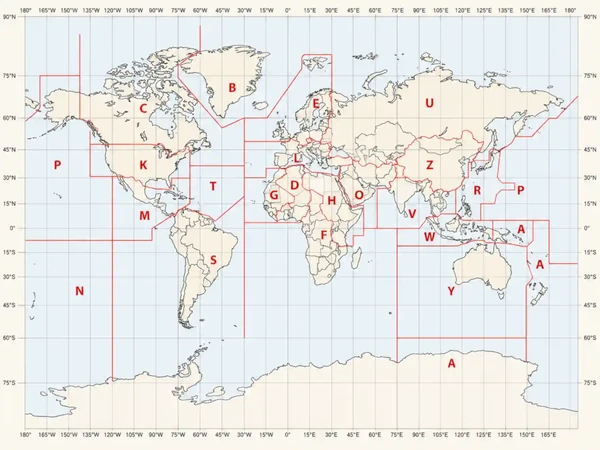
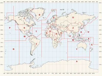
- The second group is the four-letter ICAO location identifier for the forecast airport; for example, KINL.
-
Contiguous United States ICAO Prefixes:
- In the contiguous 48 states, prefix the three-letter domestic station identifier with K to form the four-letter ICAO identifier, for example, SEA becomes KSEA.
-
ICAO Prefixes Outside the Contiguous United States:
- PA = Alaska (for example, PANC for Anchorage Int'l, AK).
- PH = Hawaii (for example, PHNL for Honolulu Int'l, HI).
- CU, CW, CY, CZ = Canada.
- MM = Mexico.
- Western Caribbean is "M" followed by the individual country's letter; i.e., Cuba is "MU" Dominican Republic "MD;" the Bahamas "MY".
- Eastern Caribbean is "T" followed by the individual country's letter; i.e., Puerto Rico is "TJ".
- For a complete worldwide listing see ICAO Document 7910, Location Indicators.
Group 3: Times
-
Issue Date and Time:
- The date and time element is the date and time the forecast is actually prepared.
- The TAF issue time uses six digits in DDHHMM format followed by Z: the two-digit day of the month, hour, and minute in UTC (Coordinated Universal Time).
- Example, 122323Z: The TAF was issued on the 12th day of the month at 2323Z.
- Military TAFs place the valid-period group immediately after the ICAO station identifier (omitting the date and time element) rather than preceding it with a separate issue-time group.
- When a military TAF is amended, corrected, or routinely delayed, the applicable time is appended as a remark at the end of the forecast whereas on a civil TAF the date and time element are updated.
- For example, AMD 122045Z: TAF Amended at 2045Z on the 12th day of the month.
-
Valid Period Date and Time:
- The UTC valid period of the forecast consists of two four-digit sets, separated by a "/".
- The first four-digit set is a two-digit date followed by the two-digit beginning hour, and the second four-digit set is a two-digit date followed by the two-digit ending hour.
- Although most airports have a 24-hour TAF, a select number of airports have a 30-hour TAF.
- In the case of an amended forecast, or a forecast which is corrected or delayed, the valid period may be for less than 24 hours.
- In a TAF, "AMD NOT SKED" means amendments are not scheduled because the airport or terminal operates part time (less than 24 hours per day).
- The time observations are scheduled to end and/or resume will be indicated by expanding the AMD NOT SKED statement.
- Expanded statements will include:
- Observation ending time (AFT DDHHmm; for example, AFT 120200).
- Scheduled observation resumption time (TIL DDHHmm; for example, TIL 171200Z).
- Period of observation unavailability (DDHH/DDHH; for example, 2502/2512).
- The UTC valid period of the forecast consists of two four-digit sets, separated by a "/".
Group 4: Forecast Meteorological Conditions
- Forecast meteorological conditions consist of wind, visibility, significant weather, sky condition, and optional elements such as wind shear.
- Wind, visibility, and sky condition elements are always included in the initial time group of the forecast.
- Weather is included only if significant to aviation.
-
Group 4a: Wind:
- Wind direction is displayed in tens of degrees from true north (first 3 digits).
- Wind velocity is displayed in whole knots (last 2 digits or 3 digits if 100 knots or greater).
- The contraction "KT" follows to denote the units of wind speed.
- Example, 18010KT: Wind is blowing from 180° at 10 knots.
- Wind gusts are noted by the letter "G" appended to the wind speed followed by the highest expected gust.
- Example, 35012G20KT: Wind blowing from 350° at 12 knots, gusting to 20 knots.
- Wind speed for the most recent 10 minutes is used to determine gusts, and the maximum peak is reported.
- International TAFs may express wind speed in kilometers per hour (KMH) or meters per second (MPS) instead of knots (KT).
- Calm winds (3 knots or less) are encoded as 00000KT.
- In military TAFs, when the forecast wind direction varies by 60° or more, the expected range (separated with a "V") may be appended as a remark.
- Example, WND 270V350: Wind is variable between 270° and 350°.
- VRB indicates variable winds and replaces the three-digit wind direction when a prevailing direction cannot be forecast.
- Example, VRB04KT: Wind is variable at 4 knots.
-
Group 4b: Visibility, Weather, and Obstructions to Vision:
- TAFs report prevailing visibility up to and including 6 statute miles (SM), including fractions, followed by SM.
- Example, 1/2SM = Visibility is one-half mile, 4SM = visibility is four statute miles, P6SM = visibility is more than six statute miles.
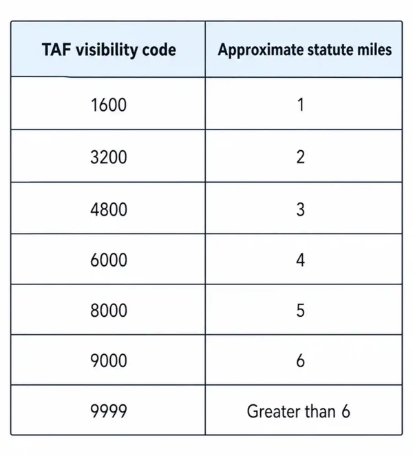
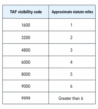
- Military and international TAFs forecast prevailing visibility is generally reported in meters and rounded down to the nearest reportable value with 9999 meaning prevailing visibility is 10 kilometers or more.
- In all cases, P6SM or 9999 does not mean unlimited visibility. []
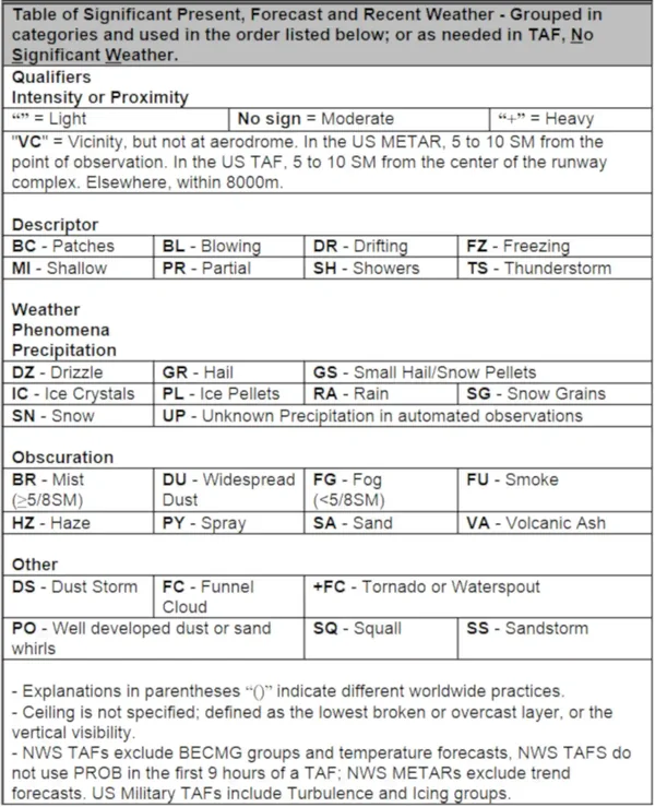
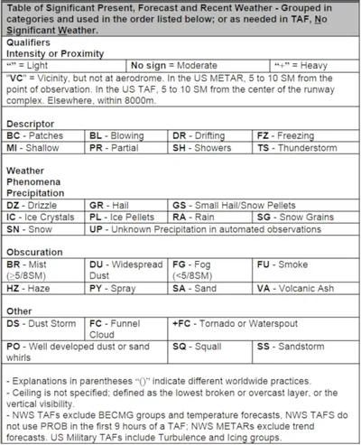
- When forecast prevailing visibility is 9,000 meters or less—or 6 statute miles or less, the significant weather or obstruction causing the reduction is included using METAR weather codes.
- The significant-weather group is omitted when no significant weather is forecast.
- TAFs report prevailing visibility up to and including 6 statute miles (SM), including fractions, followed by SM.
-
Group 4c: Weather Phenomena:
- TAFs use the same weather qualifiers and phenomena codes as METARs, except UP (unknown precipitation) is not used. []
- NSW indicates no significant weather, and is used only in a TEMPO group (explained below) to indicate that previously forecast significant weather is expected to end.
- When no significant weather is forecast in the initial period or an FM group (explained below), the weather group is omitted.
- NSW applies only to significant weather - not to wind, visibility, or sky condition.
- TAFs use the same weather qualifiers and phenomena codes as METARs, except UP (unknown precipitation) is not used. []
-
Group 4d: Sky Condition Group:
- The sky-condition group describes forecast cloud cover and height, or vertical visibility into a surface-based total obscuration. []
- Cloud layers are forecast in ascending order of height.
- A ceiling is the lowest broken or overcast layer, or surface-based vertical visibility into a complete obscuration.
- Cloud-layer heights indicate the base of each layer.
- Cloud and vertical-visibility heights are encoded in hundreds of feet above ground level (AGL).
- Example, SCT005 BKN025CB: Scattered clouds at 500 feet and a broken cumulonimbus ceiling at 2,500 feet.
- Example, VV008: Vertical visibility of 800 feet into a surface-based total obscuration.
- Each cloud-layer group uses a three-letter sky-cover code followed by a three-digit height; CB indicates cumulonimbus, when forecast.
- Cumulonimbus clouds (CB) are the only cloud type forecast in TAFs.
- TAFs use SKC for clear skies; CLR is not used.
- As in METAR, ceiling layers are not designated in the TAF code.


Group 4e: Optional (Wind Shear):
- The three digits following WS identify the top of the wind-shear layer in hundreds of feet AGL.
- Example, WS020/22030KT: Wind shear at 2000' with wind from 220 at 30 knots.
- After the slash, the five-digit wind group gives the true wind direction and speed at the top of the wind-shear layer, followed by KT for knots.
- When non-convective low-level wind shear is forecast from the surface through 2,000 feet AGL, the WS group appears after the cloud group.
- Some North American TAFs may use WSCONDS (wind shear conditions) when wind shear cannot be forecast accurately enough to provide numeric data.
- The wind-shear group is omitted when non-convective low-level wind shear is not forecast.
Group 4f: Icing:
- Military TAFs contain icing groups, when forecast.
- The group forecasts non-thunderstorm icing.
- The group is repeated when multiple icing layers are forecast.
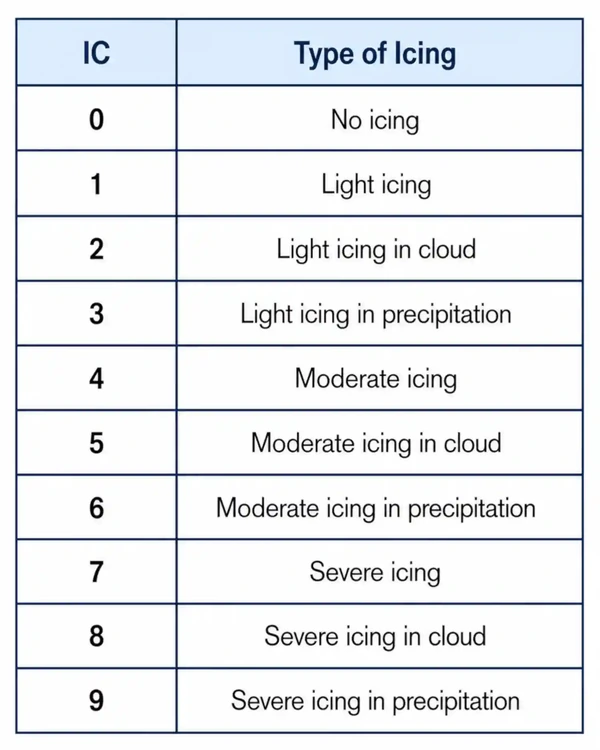
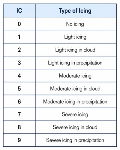
- The first digit is always a 6 which identifies the icing group.
- The second digit identifies the icing type and intensity. []
- The next three numbers show the height of the ice layer in hundreds of feet AGL.
- The final digit identifies the icing layer thickness in thousands of feet.
- If an icing layer is more than 9,000 feet thick, the icing group is repeated with the second group's base corresponding to the top of the first layer.
- Example, 640003: Moderate icing at or below 100 feet AGL in a 3,000-foot layer.
- Example, 641104: Moderate icing from 11,000 through 15,000 feet AGL.
- Example, 641109 642005: Moderate icing from 11,000 through 25,000 feet AGL. The first group covers 11,000-20,000 feet; the repeated group continues the layer from 20,000–25,000 feet.
Group 4g: Turbulence:
- Military TAFs contain turbulence groups, when forecast.
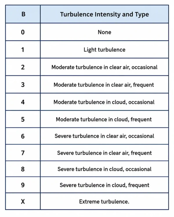
- The first digit is always a 5 which identifies the turbulence group.
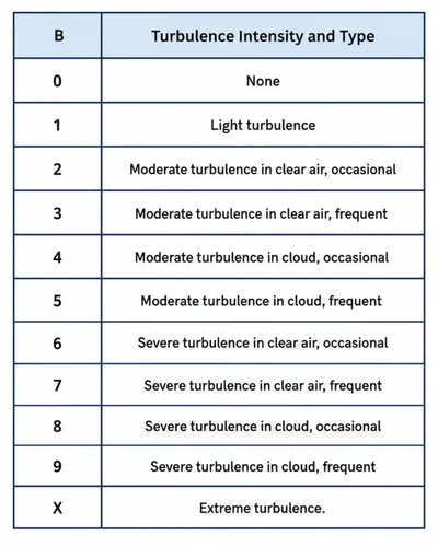
- The second digit identifies the turbulence intensity. []
- The next three numbers show the height of the turbulence layer in hundreds of feet AGL.
- The final digit identifies the turbulence layer thickness in thousands of feet.
- Example, 510302: Light turbulence from 3000' AGL in a 2000' layer.
- Thunderstorms imply moderate or greater turbulence, so this group forecasts only non-thunderstorm turbulence.
Group 4h: Altimeter:
- Military TAFs may include the lowest forecast altimeter setting for the applicable forecast period.
- The altimeter group appears in the initial forecast period and in subsequent FM and, when applicable, BECMG groups (explained below).
- The altimeter group is not included in TEMPO groups (explained below).
- The forecast minimum altimeter setting can assist pilots during lost-communications operations in instrument meteorological conditions (IMC).
- QNH identifies an altimeter setting referenced to mean sea level.
- INS indicates that the altimeter setting is expressed in inches of mercury.
- QNE refers to the standard-pressure setting of 29.92 inches of mercury (1013.25 hPa), rather than a forecast station pressure.
- QFE is the actual station pressure not corrected to sea level.
- International TAFs may express QNH in hectopascals (hPa).
- Example, QNH2981INS: QNH of 29.81 inches of mercury.
- A leading Q followed by four digits gives pressure hPa.
- Example, Q1013: Pressure of 1013 hPa.
Group 4i: Remarks:
- Military TAF remarks are introduced by RMK.
- Remarks provide clarifying or supplemental forecast information.
- In TAFs, VC (vicinity) refers to the area 5–10 statute miles from the center of the airport’s runway complex and is used only with fog, showers, or thunderstorms.
- An optional temperature group may be included to support local operations, especially helicopter and vertical/short takeoff and landing (V/STOL) operations requiring density-altitude information.
Change Group Terminology
- If a significant, lasting change in any of the elements is expected during the valid period, a new time period with the changes is included.
- Except in an FM group, a change group includes only the elements expected to change; omitted elements carry over from the preceding forecast group.
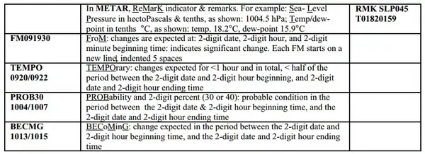
- Each change group begins a new forecast period and is presented on a new line. []
- More than one change group may be reported.
- The TAF is valid from the time mentioned up to, but not including, the "to" time.
- Each change indicator marks a time group within the TAF report.
-
FM (From) Group:
- The FM group indicates a rapid change, usually occurring in less than one hour, in prevailing conditions is expected.
- Typically, a rapid change of prevailing conditions to more or less a completely new set of prevailing conditions is associated with a synoptic feature passing through the terminal area (cold or warm frontal passage).
- The FM heading is followed by a date and time (date, hours and minutes) indicating when the forecast time expected to begin which continues until the next change group or until the end of the current forecast.
- Example, FM281200: On the 28th of the month from 1200Z to end at 0000Z.
- FM includes all normal forecasted items (wind, visibility, weather, and sky condition).
- Weather will be omitted in "FM" groups when it is not significant to aviation but will not include the contraction NSW.
- The FM group indicates a rapid change, usually occurring in less than one hour, in prevailing conditions is expected.
-
BECMG (Becoming) Group:
- The BECMG indicates a gradual change expected to occur at an unspecified time within the stated period and is only used on military and international TAFs.
- The BECMG group is used when a gradual change in conditions is expected over a longer time period, usually two hours.
- The time period when the change is expected is two four-digit groups separated by a "/", with the beginning date and hour, and ending date and hour of the change period which follows the BECMG indicator.
- Example, BECMG 1718: From 1700Z to 1800Z.
- Example, OVC012 BECMG 0114/0116 BKN020: Ceiling is one thousand two hundred overcast, becoming two thousand broken between 1400Z on the 1st and 1600Z on the 1st.
-
TEMPO (Temporary) Group:
- TEMPO is followed by two four-digit date-and-hour groups separated by a slash, identifying the beginning and ending of the temporary-change period.
- TEMPO indicates conditions expected to last generally less than one hour at a time and occur during less than half of the stated period.
- Example, TEMPO 1902: Temporarily between 1900 up to, but not including, 0200Z.
- Example, SCT030 TEMPO 0519/0523 BKN030: Three thousand scattered with occasional ceilings three thousand broken between 1900Z on the 5th and 2300Z on the 5th.
- Example, 4SM HZ TEMPO 1900/1906 2SM BR HZ: Visibility four in haze with occasional visibility two in mist and haze between 0000Z on the 19th and 0600Z on the 19th.
-
PROB (Probability) Group:
- A PROB group gives the probability of a thunderstorm or precipitation event and may include associated wind, visibility, weather, and sky conditions.
- The indicator combines PROB with a two-digit probability value: PROB30 or PROB40.
- PROB30 represents a 30–39% probability, while PROB40 represents a 40–49% probability.
- This is followed by two four-digit groups separated by a "/", giving the beginning date and hour, and the ending date and hour of the time period during which the thunderstorms or precipitation are expected.
- For example, PROB30 1010/1014 1SM -TSRA indicates a 30 percent probability of one-statute-mile visibility with thunderstorms and light rain from 1000Z to 1400Z on the 10th.
- The NWS does not use PROB40 in TAFs; U.S. military-generated TAFs may include it.
- The NWS does not use PROB30 during the first nine hours of a TAF’s valid period.
- Example, PROB40 2221/2302 1/2SM +TSRA: Chance between 2100Z and 0200Z of one-half-statute-mile visibility in thunderstorms and heavy rain.
- Example, PROB30 3010/3014 1SM RASN: Chance between 1000Z and 1400Z of one-statute-mile visibility in mixed rain and snow.
Amazon Alexa Tools
- Through Amazon's Alexa, you can enable skills such as:
Model Output Statistics
- Model Output Statistics (MOS) uses statistical relationships between numerical model output, observations, and other data to produce improved forecast guidance.
- NOAA (National Oceanic and Atmospheric Administration) produces MOS guidance for more than 11,000 sites across the United States and its territories; available forecast ranges vary by product.
- MOS guidance includes ceiling and visibility forecasts that help users assess expected VFR (Visual Flight Rules), MVFR (marginal visual flight rules), IFR (Instrument Flight Rules), and LIFR (Low Instrument Flight Rules) flight categories.
- Use MOS and LAMP as forecast guidance alongside current observations, TAFs when available, and other pertinent weather products.
- For aviation-specific guidance, see NOAA’s Localized Aviation Model Output Statistics Program (LAMP).
Terminal Aerodrome Forecast Interactive Scenario
Interactive Scenario
Loading scenario details...
Scenario Complete
Terminal Aerodrome Forecast Knowledge Check
Choose the knowledge check that matches your current training for Terminal Aerodrome Forecast.
 Private Pilot
PPL knowledge check
Core Knowledge Review
Review foundational knowledge, key concepts, and practical considerations. Topic: Terminal Aerodrome Forecast.
- Immediate feedback
- Answer explanations
- Account progress tracking
Sport Pilot
Sport knowledge check
Sport Pilot Knowledge
Review the foundational knowledge and decisions used in sport-pilot operations. Topic: Terminal Aerodrome Forecast.
- Immediate feedback
- Answer explanations
- Account progress tracking
 Commercial Pilot
CPL knowledge check
Advanced Application
Apply knowledge to advanced operations, risk management, and aeronautical decision-making. Topic: Terminal Aerodrome Forecast.
- Immediate feedback
- Answer explanations
- Account progress tracking
 Instrument Rating (Airplane)
Instrument knowledge check
Instrument Knowledge
Practice the procedures, systems, weather, and decisions used in instrument flight. Topic: Terminal Aerodrome Forecast.
- Immediate feedback
- Answer explanations
- Account progress tracking
 Flight Instructor
CFI knowledge check
Instructor Knowledge
Review the technical knowledge expected of an airplane flight instructor. Topic: Terminal Aerodrome Forecast.
- Immediate feedback
- Answer explanations
- Account progress tracking
 Instrument Instructor
CFII knowledge check
Instrument Instructor Knowledge
Review instrument knowledge at the depth expected of an instrument flight instructor. Topic: Terminal Aerodrome Forecast.
- Immediate feedback
- Answer explanations
- Account progress tracking
 Small UAS
sUAS knowledge check
Remote Pilot Knowledge
Review the operating rules, risk controls, and aeronautical knowledge for small UAS. Topic: Terminal Aerodrome Forecast.
- Immediate feedback
- Answer explanations
- Account progress tracking
Why Take a Quiz?
Quizzes reinforce key concepts, identify knowledge gaps, and build confidence for real-world decisions. Quiz material is representative of the information provided here and is not based on or sourced from the Federal Aviation Administration test bank.
Terminal Aerodrome Forecast Conclusion
- The U.S. uses the ICAO world standard for aviation weather reporting and forecasting.
- For more information, a paper copy of Federal Aviation Administration (FAA-H-8083-28) Aviation Weather Handbook [Amazon] is available for purchase.
- A digital copy of the Federal Aviation Administration (FAA-H-8083-28B) Aviation Weather Handbook is available from the FAA.
- TAFs are not static products; forecasters issue amendments when the current forecast no longer adequately describes ongoing weather or is not representative of expected conditions. Use TAFs with all other pertinent weather products.
- Improve your weather skills with FAA provided (and WINGS credited) resources by going to https://www.faasafety.gov/ and type "weather" into the search bar.
- Still looking for something? Continue searching:
Terminal Aerodrome Forecast References
- Federal Aviation Administration (FAA-H-8083-28B) Aviation Weather Handbook.
- Federal Aviation Administration - Pilot/Controller Glossary.
- Aviation Weather Center - TAF Data.
- Aviation Weather Center - TAF Format and Decoding Guide.
- Aircraft Owners and Pilots Association (AOPA) - Alexa, Do You Speak Pilot?.
- Aeronautical Information Manual (7-1-28) Key to Aerodrome Forecast (TAF) and Aviation Routine Weather Report (METAR).
- Aeronautical Information Manual (7-1-29) International Civil Aviation Organization (ICAO) Weather Formats.
- CFI Notebook.net - Chart Supplement U.S..
- National Weather Service (NWS) Weather Forecast Office.
- Air Force Pamphlet (11-238) Aircrew Quick Reference to METAR and TAF Codes.