Clouds In The Aviation Environment
Clouds are visible indications of atmospheric processes which provide clues on frontal activity and general weather patterns.
Introduction to Clouds In The Aviation Environment
- Clouds are visible indications of atmospheric processes which provide clues on frontal activity and general weather patterns
- While there is no requirement for a pilot to be able to identify every cloud type by name and classification, basic knowledge can mean the difference between a comfortable flight, and a dangerous one
- Much like a river, as you approach, you can get a feel for currents and stability by how it looks - Clouds are no different
- Clouds form based on four factors
- Clouds are grouped by families according to their shape, behavior, and altitudes:
- For flight planning purposes prevailing visibility and clouds heights are reported by meteorological sources
- Calculating cloud heights provides an accurate estimation of what to expect or correlation of other information
- Solid clouds usually indicate frontal movement, while broken clouds suggest turbulence
- Rain clouds contain the prefix or suffix nimbus
- Nimbus: heavy or violent precipitation
- Cumulonimbus: thunderstorm
- Warmer air is more humid because it can hold more moisture
- To saturate the air, you must evaporate or cool it
- Test your understanding of Clouds In The Aviation Environment by applying your knowledge in the interactive scenario, comparing your performance against the applicable Airman Certification Standards, and concluding with the topic summary to reinforce the key concepts before moving on to the next lesson.
Clouds In The Aviation Environment Key Highlights
- Clouds provide important visual indicators of atmospheric moisture, stability, lift, turbulence, and changing aviation weather conditions.
- Cloud type, height, coverage, and vertical development help pilots evaluate visibility, ceiling, precipitation, and weather hazards.
- Low clouds can create reduced ceilings and visibility that affect VFR operations, approach planning, and airport accessibility.
- Cumuliform clouds indicate vertical development and may be associated with turbulence, showers, thunderstorms, and convective activity.
- Stratiform clouds often indicate stable air, widespread cloud layers, reduced ceilings, drizzle, or steady precipitation.
- Towering cumulus and cumulonimbus clouds signal strong convection and significant hazards such as lightning, hail, wind shear, and severe turbulence.
- Clouds containing supercooled liquid water can create aircraft icing hazards when temperatures are near or below freezing.
- Pilots should compare observed cloud conditions with METARs, TAFs, satellite imagery, PIREPs, and weather advisories during flight planning.
- Cloud clearance requirements vary by airspace, altitude, and flight rules and are essential for regulatory compliance and collision avoidance.
- Understanding clouds in the aviation environment improves weather interpretation, hazard recognition, and overall flight safety.
Cloud Formation
- Formation requires moisture to be lifted, where it condenses at its dew-point into visual moisture.
-
Vertical Lifting Mechanisms:
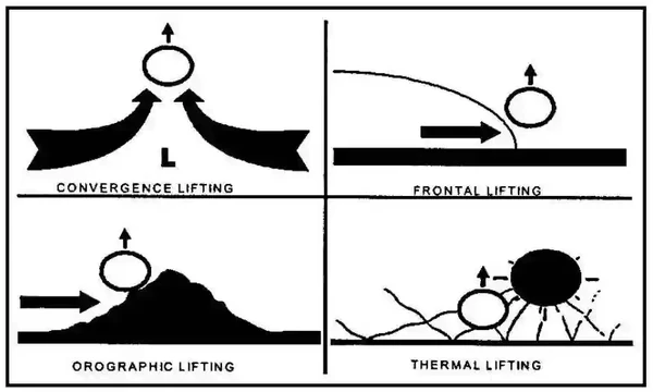
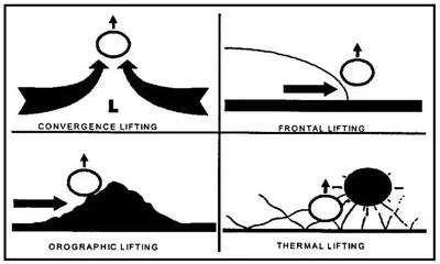
- The acronym COFT labels convergence, orographic, frontal, and thermal/buoyant lifting mechanisms. []
-
Convergence Lifting:
- Convergence lifting occurs when two air masses converge on one another
-
Orographic Lifting:
- Orographic lifting occurs when air is forced up the side of a mountain until it cools and condenses
-
Frontal Lifting:
- Frontal lifting is caused by the movement of dissemilar air masses
- Cold Front: cold air encounters warmer air, pushing the warm air up, causing lifting
- Warm Front: warm air encounters cooler air where it will rise above it, causing lifting
-
Thermal Lifting/Buoyancy:
- Thermal, also called convective lifting, occurs when the ground is heated, causing the warmer air to rise
- Vertical Motion Effects on an Unsaturated Air Parcel:
- As a bubble or parcel of air ascends (rises), it moves into an area of lower pressure (pressure decreases with height).
- As this occurs, the parcel expands.
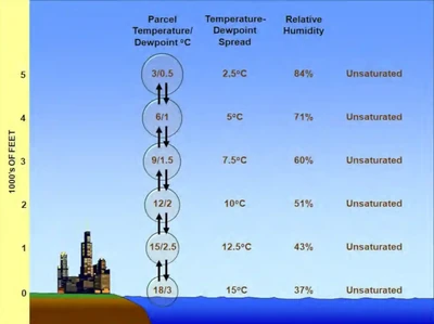
- This requires energy (or work), which takes heat away from the parcel, so the air cools as it rises (adiabatic process). []
- The term "adiabatic" means that no heat transfer occurs into, or out of, the parcel.
- Air has low thermal conductivity (see Aviation Weather Handbook Table 5-3), so transfer of heat by conduction is negligibly small.
- The rate at which the parcel cools as it is lifted is called the lapse rate.
Units used below: feet (ft).
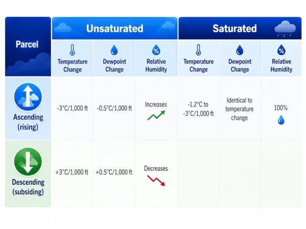
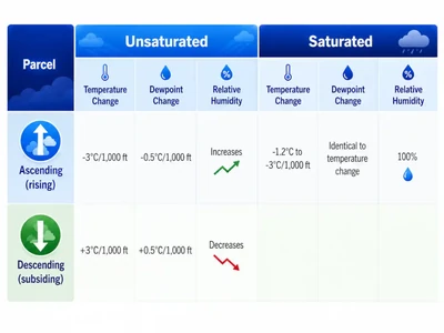
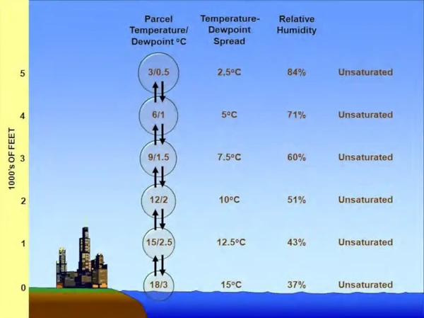
- The lapse rate of a rising unsaturated parcel (air with relative humidity less than 100 percent) is approximately 3°C per 1,000 ft (9.8°C per km).
- This is called the dry adiabatic lapse rate; it is higher than the standard lapse rate of 2°C per 1,000 feet.
- This means that for each 1,000-ft increase in elevation, the parcel’s temperature decreases by 3°C.
- Concurrently, the dewpoint decreases approximately 0.5°C per 1,000 ft (1.8°C per km).
- The parcel’s temperature-dewpoint spread decreases, while its relative humidity increases.
- This process is reversible if the parcel remains unsaturated and, thus, does not lose any water vapor.
- A descending (subsiding) air parcel compresses as it moves into an area of higher pressure.
- The atmosphere surrounding the parcel does work on the parcel, and energy is added to the compressed parcel, which warms it.
- Thus, the temperature of a descending air parcel increases approximately 3°C per 1,000 ft (9.8°C per km).
- Concurrently, the dewpoint increases approximately 0.5°C per 1,000 ft (1.8°C per km).
- The parcel’s temperature-dewpoint spread increases, while its relative humidity decreases.
- As a bubble or parcel of air ascends (rises), it moves into an area of lower pressure (pressure decreases with height).
- Vertical Motion Effects on a Saturated Air Parcel:
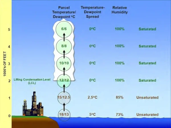
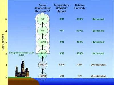
- The Lifted Condensation Level (LCL) is the level at which a parcel of moist air lifted dry adiabatically becomes saturated. At this altitude, the temperature-dewpoint spread is zero and relative humidity is 100 percent.
- Further lifting of the saturated parcel results in condensation, cloud formation, and latent heat release. Because the heat added during condensation offsets some of the cooling due to expansion, the parcel now cools at the moist adiabatic lapse rate, which varies between approximately 1.2°C per 1,000 ft (4°C per km) for very warm saturated parcels to 3°C per 1,000 ft (9.8°C per km) for very cold saturated parcels. Concurrently, the parcel’s dewpoint decreases at an identical rate. For simplicity, examples shown in this handbook use a moist adiabatic lapse rate of 2°C per 1,000 ft. Regardless of temperature, the relative humidity remains constant at about 100 percent.
- As the saturated air parcel expands and cools, its water vapor content decreases (see Figure 12-2). This occurs because some of the water vapor is condensed to water droplets or deposited into ice crystals to form a cloud. This process is triggered by the presence of microscopic cloud condensation (and ice) nuclei, such as dust, clay, soot, sulfate, and sea salt particles. The cloud grows vertically deeper as the parcel continues to rise.
- In Figure 12-2, at the surface the air parcel has a temperature of 18°C and a dewpoint of 13°C, indicating that it is unsaturated. As the parcel ascends, its temperature decreases at the dry adiabatic lapse rate of 3°C per 1,000 ft, while the dewpoint decreases at 0.5°C per 1,000 ft. The temperature-dewpoint spread decreases while relative humidity increases until the parcel achieves saturation at its LCL of 2,000 ft. As the parcel continues to ascend, condensation produces cloud formation. Because the heat added during condensation offsets some of the cooling due to expansion, the parcel now cools at the moist adiabatic lapse rate of 2°C per 1,000 ft. The parcel’s dewpoint decreases at an identical rate as the lost water vapor condenses to form the cloud. The relative humidity of the ascending saturated (i.e., cloudy) parcel remains constant at about 100 percent.
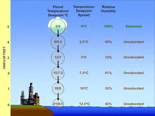
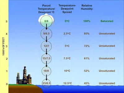
- A descending saturated air parcel quickly becomes unsaturated (see Figure 12-3). Its temperature increases at 3°C per 1,000 ft, while its dewpoint increases at 0.5°C per 1,000 ft (see Table 12-1). The temperature-dewpoint spread increases while relative humidity decreases.
- At 5,000 ft, both the temperature and dewpoint of the air parcel are 6°C, indicating that it is saturated. As the parcel descends, it quickly becomes unsaturated. Its temperature increases 3°C per 1,000 ft, while its dewpoint increases at 0.5°C per 1,000 ft. The temperature-dewpoint spread increases while relative humidity decreases until the parcel reaches the surface. Note that the parcel is now much warmer and drier at the surface than when it began the vertical motion process in Figure 12-2.
Cloud Levels
- Clouds can be broken up into low, middle, and high clouds, each with their own characteristics and considerations. []
-
Low Clouds:
- In middle latitudes, low clouds generally have bases from near the surface to about 6,500' AGL. This classification concerns the cloud base; clouds with significant vertical development may extend well above 6,500'.
- Contain water, but sometimes may contain super-cooled water (icing hazard).
-
Stratus Clouds:
- Stratus clouds are layered
- Stratus clouds form in stable air near the surface due to cooling from below
- Stratus clouds form when moist stable air lifts up sloping terrain or when warm rain evaporates as it falls through the cool air
- Restrict visibility.
-
Nimbostratus Clouds:
- Cause widespread areas of rain or snow
- Thick
-
Stratocumulus Clouds:
- Stratocumulus clouds are white puffy clouds that form as stable air lifts
- Often form as a stratus layer breaks up or as cumulus clouds spread out
- Generally lack enough moisture to cause rain
-
Middle Clouds:
- In middle latitudes, middle clouds generally have bases from approximately 6,500' to 23,000' above the surface. These approximate limits vary with latitude and overlap the ranges of other cloud families.
- Composed of water crystals, ice crystals, or super-cooled water
- Middle clouds may contain turbulence and potential severe icing.
-
Altostratus Clouds:
- Flat, dense clouds that cover a wide area
- Minimal turbulence.
-
Altocumulus Clouds:
- Form when altostratus clouds start to break up. []
- Light turbulence
-
High Clouds:
- In middle latitudes, high clouds generally have bases from approximately 16,500' to 40,000' above the surface. These approximate limits vary with latitude and overlap the middle-cloud range. []
- Even if not operating within high clouds, they can still provide indications of the atmosphere
- White or light gray color composed mainly of ice crystals
- Seldom pose a serious turbulence or icing hazard.
-
Cirrus Clouds:
- Thin and wispy
- Usually form above 20,000' AGL.
-
Cirrostratus Clouds:
- Form long bands or sheets
- Moisture content is low and poses no icing hazard.
-
Cirrocumulus Clouds:
- Look like cotton
- May produce light turbulence

Clouds With Vertical Development
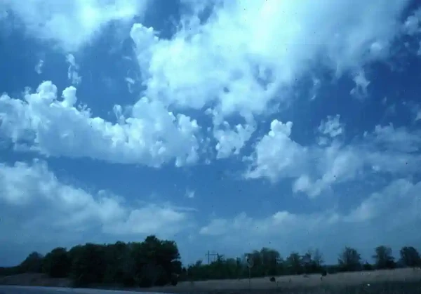
- Very turbulent and unstable although typically fluffy in appearance giving you the false sense of "fair weather cumulus"
-
Cumulus Clouds:
- Form in convective currents resulting from the heating of the Earth's surface
- Flat bottoms with dome-shaped tops
- Widely spaced cumulus clouds are called fair-weather cumulus
- Fair-weather cumulus indicate some turbulence, but little icing or precipitation
-
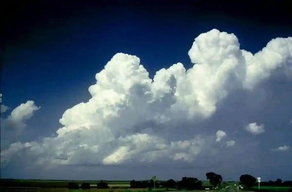
Towering Cumulus Clouds:
- Towering Cumulus clouds form from deep areas of unstable air, which can produce moderate to heavy turbulence with icing conditions. []
- Often form prior and eventually result in thunderstorms
-
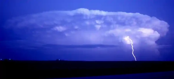
Cumulonimbus Clouds:
- More commonly called thunderstorms. []
- Form in unstable air with large amounts of moisture
- Very hazardous to flying
Other Clouds
-
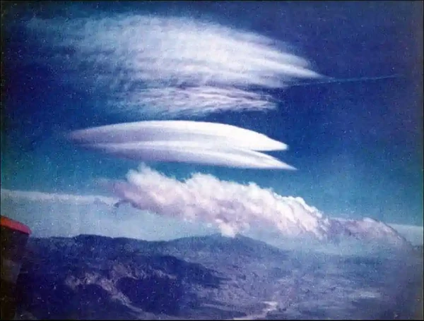
Lenticular Clouds:
- Lenticular clouds form on the leeward side of mountains. []
-
Cap Clouds:
- Form during rising air
-
Rotor Clouds:
- Rotor clouds are typically associated with turbulence. []
- They are indicitive of a local rolling wind phenomenon
- Just as important, however, is their presence alerts pilots to the possibility of extreme updrafts followed by extreme downdrafts, in rapid succession
-
Roll and Wall Clouds:
- Occur in severe and fast-moving thunderstorms
Reporting Prevailing Visibility
- Aviation Routine Weather Reports (METARs) declare surface (horizontal) visibility in terms of statute miles and increments thereof; e.g., 1/16, 1/8, 16, 1/4, 16, 8, 2, 5/8, 3/4, 7/8, 1, 1 1/8, etc. (Visibility reported by an unaugmented automated site is reported differently than in a manual report, i.e., Automated Surface Observation System/Automated Weather Observation System) (ASOS/AWOS): 0, 1/16, 1/8, 1/4, 1 1/2, 1 3/4, 2, 1 3/4, 1, 1 1/4, 1 1/4, 2, 2 1/2, 3, 4, 5, etc., AWOS: M1/4, 1/4, 1/2, 3/4, 1, 1 1/4, 1 1/2, 1 3/4, 2, 2 1/2, 3, 4, 5, etc.) The ability to see and identify preselected and prominent objects at a known distance from the usual point of observation determines visibility. Visibilities that are determined to be less than 7 miles identify the obscuring atmospheric condition; e.g., fog, haze, smoke, etc., or combinations thereof
- Prevailing visibility is the greatest visibility equaled or exceeded throughout at least one-half of the horizon circle, not necessarily contiguous. Segments of the horizon circle which may have significantly different visibility are reported in the remarks section of the weather report; i.e., "the southeastern quadrant of the horizon circle may be determined to be 2 miles in mist while the remaining quadrants are determined to be 3 miles in mist"
- When the prevailing visibility at the usual point of observation, or the tower level, is less than 4 miles, certificated tower personnel will take visibility observations in addition to those taken at the usual point of observation. The lower of these two values becomes the prevailing visibility for aircraft operations
Reporting of Cloud Heights/Bases
- Ceiling, by definition in the Code of Federal Regulations and as used in aviation weather reports and forecasts, is the height above ground (or water) level of the lowest layer of clouds or obscuring phenomenon that is reported as "broken," "overcast," or "obscuration". []
- Example: a Terminal Aerodrome Forecast (TAF), which reads "BKN030," refers to the height above ground level indicates that the height of the station must be added to achieve the height above sea level.
- The Aeronautical Information Manual defines "broken," "overcast," and "obscuration".
- Pilots usually report height values above Mean Sea Level (MSL) since they determine heights by the altimeter.
- This is taken into account when disseminating and otherwise applying information received from pilots.
- "Ceiling" heights are always Above Ground Level (AGL).
- In reports disseminated as Pilot Reports (PIREPs), height references are given the same as received from pilots, that is, above MSL.
- In area forecasts or inflight advisories, ceilings are denoted by the contraction "CIG" when used with sky cover symbols as in "LWRG TO CIG OVC005," or the contraction "AGL" after the forecast cloud height value.
- When the cloud base is given in height above MSL, it is indicated by the contraction "MSL" or "ASL" following the height value.
- The heights of clouds tops, freezing level, icing, and turbulence are always given in heights above ASL or MSL.


Calculating Cloud Bases
- Cloud bases aid in VFR (Visual Flight Rules) planning or when icing is a concern.
- The formula provides data relevant for planning, but conditions can change rapidly.
-
Cloud Bases Formula:
- Temperature-Dew Point (°C) divided by 2 (standard lapse rate) x 1,000 = Base of clouds.
- Temperature-Dew Point (°F) divided by 3.6 (standard lapse rate) x 1,000 = Base of clouds.
-
Cloud Bases Calculation Example:
- Temperature: 10°C / 50°F.
- Dew Point: 5 °C / 41°F.
- (10-5) ÷ 2 x 1,000 = 2,500' MSL.
- (50-41) ÷ 3.6 x 1,000 = 2,500' MSL.
-
Clouds In The Aviation Environment Interactive Scenario
Interactive Scenario
Loading scenario details...
Scenario Complete
Clouds In The Aviation Environment Knowledge Check
Choose the knowledge check that matches your current training for Clouds In The Aviation Environment.
 Private Pilot
PPL knowledge check
Core Knowledge Review
Review foundational knowledge, key concepts, and practical considerations. Topic: Clouds In The Aviation Environment.
- Immediate feedback
- Answer explanations
- Account progress tracking
Sport Pilot
Sport knowledge check
Sport Pilot Knowledge
Review the foundational knowledge and decisions used in sport-pilot operations. Topic: Clouds In The Aviation Environment.
- Immediate feedback
- Answer explanations
- Account progress tracking
 Commercial Pilot
CPL knowledge check
Advanced Application
Apply knowledge to advanced operations, risk management, and aeronautical decision-making. Topic: Clouds In The Aviation Environment.
- Immediate feedback
- Answer explanations
- Account progress tracking
 Instrument Rating
Instrument knowledge check
Instrument Knowledge
Practice the procedures, systems, weather, and decisions used in instrument flight. Topic: Clouds In The Aviation Environment.
- Immediate feedback
- Answer explanations
- Account progress tracking
 Flight Instructor
CFI knowledge check
Instructor Knowledge
Review the technical knowledge expected of an airplane flight instructor. Topic: Clouds In The Aviation Environment.
- Immediate feedback
- Answer explanations
- Account progress tracking
 Instrument Instructor
CFII knowledge check
Instrument Instructor Knowledge
Review instrument knowledge at the depth expected of an instrument flight instructor. Topic: Clouds In The Aviation Environment.
- Immediate feedback
- Answer explanations
- Account progress tracking
 Small UAS
sUAS knowledge check
Remote Pilot Knowledge
Review the operating rules, risk controls, and aeronautical knowledge for small UAS. Topic: Clouds In The Aviation Environment.
- Immediate feedback
- Answer explanations
- Account progress tracking
Why Take a Quiz?
Quizzes reinforce key concepts, identify knowledge gaps, and build confidence for real-world decisions. Quiz material is representative of the information provided here and is not based on or sourced from the Federal Aviation Administration test bank.
Clouds In The Aviation Environment Conclusion
- Clouds are not just beautiful; they are also hazardous
- In areas with high humidity with present lifting criteria like Florida, clouds are clearly observed growing in real-time from the ground or the air
- A reference chart can be found on the AOPA SkySpotter major cloud types page
- See also:
- Improve your weather skills with FAA provided (and WINGS credited) resources by going to https://www.faasafety.gov/ and type "weather" into the search bar
- Test your aviation weather knowledge with the AOPA and SiriusXM Aviation Weather Quiz.
- Still looking for something? Continue searching:
Clouds In The Aviation Environment References
- Federal Aviation Administration (FAA-H-8083-28) Aviation Weather Handbook.
- Aeronautical Information Manual (7-1-14) Reporting of Cloud Heights.
- Aeronautical Information Manual (7-1-15) Reporting Prevailing Visibility.
- Aircraft Owners and Pilots Association (AOPA) - Major Cloud Types.
- Federal Aviation Administration (FAA) - Pilot/Controller Glossary.