Mountain Flying
Mountain flying, while seemingly basic, can be surprisingly dangerous, requiring proper training, and respect.
Introduction to Mountain Flying
- Your first experience of flying over mountainous terrain (particularly if most of your flight time has been over the flatlands of the midwest) could be a never-to-be-forgotten nightmare if proper planning is not done and if you are not aware of the potential hazards awaiting.
- Those familiar section lines are not present in the mountains; those flat, level fields for forced landings are practically nonexistent; abrupt changes in wind direction and velocity occur; severe updrafts and downdrafts are common, particularly near or above abrupt changes of terrain, such as cliffs or rugged areas; even the clouds look different and can build up with startling rapidity
- While you can never eliminate the hazards of mountain flying, you can certainly mitigate them by:
Mountain Flying Key Highlights
- Mountain flying presents unique hazards related to terrain, weather, wind patterns, and aircraft performance limitations.
- High density altitude conditions in mountainous areas reduce engine power, propeller efficiency, and climb performance.
- Mountain winds can create turbulence, downdrafts, updrafts, rotor activity, and dangerous mountain wave conditions.
- Pilots should cross mountain ridges at an angle to maintain maneuvering options and escape routes during deteriorating conditions.
- Terrain clearance and route planning are critical because weather and visibility can change rapidly in mountainous environments.
- Canyon flying requires careful airspeed management, turn planning, and awareness of aircraft turning radius limitations.
- Early morning operations often provide smoother air and improved aircraft performance compared to afternoon mountain conditions.
- Pilots should identify emergency landing areas and avoid committing to terrain without adequate climb performance margins.
- Weight management and fuel planning are especially important during mountain operations due to limited aircraft performance.
- Understanding mountain flying improves aeronautical decision-making, terrain awareness, and overall flight safety.
File a Flight Plan
- Plan your route to avoid topography, which would prevent a safe forced landing.
- The route should be overpopulated areas and well-known mountain passes.
- Sufficient altitude should be maintained to permit gliding to a safe landing in the event of engine failure.
-
Conduct a Winds Aloft Study:
- Don't fly a light aircraft when the winds aloft, at your proposed altitude, exceed 30 knots.
- Expect the winds to be of much greater velocity over mountain passes than reported a few miles from them.
- Approach mountain passes with as much altitude as possible.
- Downdrafts of from 1,500 to 2,000 feet per minute are not uncommon on the leeward side.
-
Conducting a Terrain Study:
- Don't fly near or above abrupt changes in terrain.
- Severe turbulence can be expected, especially in high wind conditions.
- Don't fly so far up a canyon that you get trapped.
- Some canyons run into a dead-end; always allow for a 180° turn.
Understanding Mountain Obscuration (MTOS)
- MTOS describes a visibility condition that is distinguished from IFR because ceilings, by definition, are described as "above ground level" (AGL).
- In mountainous terrain, clouds can form at altitudes significantly higher than the weather reporting station, and at the same time, nearby mountain tops may be obscured by low visibility.
- In these areas, the ground level can also vary greatly over a small area.
- Be aware if operating VFR-on-top as you could be operating closer to the terrain than you think due to cloud decks below.
- MTOS areas are identified daily on the Aviation Weather Center website:
Mountain Passes/Confined Areas
- Navigating in confined terrain when flying through mountain passes can be challenging.
- For high-traffic mountain passes, VFR checkpoints may be provided on VFR navigation charts to increase situational awareness by indicating key landmarks inside confined terrain.
- A collocated VFR waypoint and checkpoint may be provided to assist with identifying natural entry points for commonly flown mountain passes.
- Pilots should reference the name of the charted VFR checkpoint wherever possible, when making position reports on CTAF frequencies to reduce the risk of midair collisions.
- Pilots should evaluate the terrain along the route they intend to fly with respect to their aircraft type and performance capabilities, local weather, and their experience level to avoid flying into confined areas without adequate room to execute a 180° turn, should conditions require. Always fly with a planned escape route in mind.
Effects of Density Altitude
- Density altitude is the result of what the AOPA terms the Triple-H effect: high altitude and high temperature lead to high density altitude.
- Density altitude impacts takeoff performance and approach and landing performance.
- Performance figures in the aircraft owner's handbook for the length of takeoff run, horsepower, rate of climb, etc., are generally based on standard atmosphere conditions (59° Fahrenheit (15° Celsius), pressure 29.92 inches of mercury) at sea level.
- Where pilots may run into trouble when they encounter an altogether different set of conditions.
- This is particularly true in hot weather and at higher elevations.
- Aircraft operations at altitudes above sea level and at higher than standard temperatures are commonplace in mountainous areas.
- Such operations quite often result in a drastic reduction of aircraft performance capabilities because of the changing air density.
- Density altitude is a measure of air density, not to be confused with pressure altitude, true altitude, or absolute altitude.
- It is not to be used as a height reference but as a determining criterion in the performance capability of an aircraft.
- Air density and density altitude have an inverse relationship
- That is to say, air density, which decreases with altitude, causes an increase in density altitude.
- The further effects of high temperature and high humidity are cumulative, resulting in an increasing high density altitude condition.
- High density altitude reduces all aircraft performance parameters.
- To the pilot, this means that the normal horsepower output is reduced, propeller efficiency is reduced, and a higher true airspeed is required to sustain the aircraft throughout its operating parameters.
- It means an increase in runway length requirements for takeoff and landings and a decreased rate of climb.
- Example: An average small airplane requiring 1,000' for takeoff at sea-level under standard atmospheric conditions will require a takeoff run of approximately 2,000' at an operational altitude of 5,000'.
- A turbocharged aircraft engine provides some slight advantage in that it provides sea level horsepower up to a specified altitude above sea level.
- Normal pitch settings and visual cues (i.e., placing the cowling on the horizon) may be lower than used to, accounting for the reduced performance.
-
Density Altitude Advisories:
- At airports with elevations of 2,000' and higher, control towers and FSSs will broadcast the advisory "Check Density Altitude" when the temperature reaches a predetermined level.
- These advisories will be broadcast on appropriate tower frequencies or, where available, ATIS. FSSs will broadcast these advisories as a part of the Local Airport Advisory.
- These advisories are provided by air traffic facilities as a reminder to pilots that high temperatures and high field elevations will cause significant changes in aircraft characteristics.
- The pilot retains the responsibility to compute density altitude, when appropriate, as a part of preflight duties.
- All FSSs will compute the current density altitude upon request.
-
Density Altitude Precautions:
- Fly lighter, don't carry unnecessary baggage.
- Review POH for special procedures, like mixture position on takeoff, cruise, and landing (likely leaning until peak RPM).
- Fly indicated airspeeds (ground speed will be faster).
- Maneuver carefully and conservatively.
- Anticipate exaggerated deceleration and effects of flight surfaces like flaps.
- Fly early in the day when temperatures, and therefore density altitude, are lowest.
- Recall density altitude affects lift surfaces, the propeller, and the engine all at once.
Other Warnings
- VFR flight operations may be conducted at night in mountainous terrain with sound judgment and common sense. Proper pre-flight planning, giving ample consideration to winds and weather, knowledge of the terrain, and pilot experience in mountain flying are prerequisites for the safety of flight. Continuous visual contact with the surface and obstructions is a major concern, and flight operations under an overcast or in the vicinity of clouds should be approached with extreme caution.
- When landing at a high altitude field, the same indicated airspeed should be used as at low elevation fields. Remember that due to the less dense air at altitude, this same indicated airspeed actually results in higher true airspeed, a faster landing speed, and, more importantly, a longer landing distance. During gusty wind conditions that often prevail at high-altitude fields, a power approach and landing are recommended. Additionally, due to the faster groundspeed, your takeoff distance will increase considerably over that required at low altitudes.
Understanding Mountain Wave
- Mountain wave occurs when air is being blown over a mountain range or even the ridge of a sharp bluff area.
- The results may be (severe) increases/decreases in airspeed and (severe) uncommanded changes in altitude.
- As the air hits the upwind side of the range, it starts to climb, thus creating what is generally a smooth updraft, which turns into a turbulent downdraft as the air passes the crest of the ridge.
- From this point, for many miles downwind, there will be a series of downdrafts and updrafts.
- Satellite photos of the Rockies have shown mountain waves extending as far as 700 miles downwind of the range.
- Along the east coast area, such photos of the Appalachian chain have picked up the mountain wave phenomenon over a hundred miles eastward.
- All it takes to form a mountain wave is wind blowing across the range at 15 knots or better at an intersection angle of not less than 30°.
- When approaching a mountain range from the upwind side (generally the west), there will usually be a smooth updraft; therefore, it is not quite as dangerous an area as the lee of the range.
- When approaching a mountain range from the leeward side, it is always a good idea to add an extra thousand feet or more of altitude because downdrafts can exceed the climb capability of the aircraft.
- Never expect an updraft when approaching a mountain chain from the leeward side.
- Always be prepared to cope with a downdraft and turbulence.
- When approaching a mountain ridge from the downwind side, it is recommended that the ridge be approached at approximately a 45° angle to the horizontal direction of the ridge. This permits a safer retreat from the ridge with less stress on the aircraft should severe turbulence and downdraft be experienced.
- If severe turbulence is encountered, simultaneously reduce power and adjust pitch until the aircraft approaches maneuvering speed, then adjust power and trim to maintain maneuvering speed and fly away from the turbulent area.
- If mountain wave is present and a downdraft is encountered, add full power to maintain airspeed; altitude may still be lost.
Guidance on Severe Turbulence and Mountain Wave Activity (MWA)
- Pilots and controllers must understand the importance of taking appropriate action in RVSM airspace when aircraft experience severe turbulence and/or MWA that is of sufficient magnitude to significantly affect altitude-keeping.
-
Severe Turbulence:
- Severe turbulence causes large, abrupt changes in altitude and/or attitude, usually accompanied by large variations in indicated airspeed.
- Aircraft may be momentarily out of control.
- Encounters with severe turbulence must be remedied immediately in any phase of flight.
- This may initially mean slowing to maneuvering speed but also finding the most expedient way out of the phenomena.
- Severe turbulence may be associated with MWA.
Mountain Wave Activity (MWA):
- Significant MWA occurs both below and above the floor of RVSM airspace, FL 290.
- MWA generally occurs in western states in the vicinity of mountain ranges.
- It may occur when strong winds blow perpendicular to mountain ranges, resulting in up and down or wave motions in the atmosphere.
- Wave action can produce altitude excursions and airspeed fluctuations accompanied by only light turbulence.
- With sufficient amplitude, however, wave action can induce altitude and airspeed fluctuations accompanied by severe turbulence.
- MWA is difficult to forecast and can be highly localized and short-lived.
In-flight MWA Indicators (Including Turbulence):
- Altitude excursions and/or airspeed fluctuations with or without associated turbulence.
- Pitch and trim changes are required to maintain altitude with accompanying airspeed fluctuations.
- Light to severe turbulence, depending on the magnitude of the MWA.
Priority for Controller Application of Merging Target Procedures:
- ATC will use "merging target procedures" to mitigate the effects of both severe turbulence and MWA.
- The procedures below (regarding TCAS) have been adapted from existing procedures published in FAA Order JO 7110.65, Air Traffic Control, paragraph 5-1-8, Merging Target Procedures.
- Paragraph 5-1-8 calls for en route controllers to advise pilots of potential traffic that they perceive may fly directly above or below their aircraft at minimum vertical separation.
- In response, pilots are given the option of requesting a radar vector to ensure their radar target will not merge or overlap with the traffic's radar target.
- The provision of "merging target procedures" to mitigate the effects of severe turbulence and/or MWA is not optional for the controller but rather is a priority responsibility.
- Pilot requests for vectors for traffic avoidance when encountering MWA or pilot reports of "Unable RVSM due turbulence or MWA" are considered first-priority aircraft separation and sequencing responsibilities.
- (FAA Order JO 7110.65, paragraph 2-1-2, Duty Priority, states that the controller's first priority is to separate aircraft and issue safety alerts).
- Explanation of the term "traffic permitting." The contingency actions for MWA and severe turbulence detailed in Paragraph 4-6-9, Contingency Actions: Weather Encounters and Aircraft System Failures that Occur After Entry into RVSM Airspace, state that the controller will "vector aircraft to avoid merging targets with traffic at adjacent flight levels, traffic permitting." The term "traffic permitting" is not intended to imply that merging target procedures is not a priority duty. The term is intended to recognize that, as stated in FAA Order JO 7110.65, Paragraph 2-1-2, Duty Priority, there are circumstances when the controller is required to perform more than one action and must "exercise their best judgment based on the facts and circumstances known to them" to prioritize their actions. Further direction given is: "That action which is most critical from a safety standpoint is performed first."
TCAS Sensitivity
- For both MWA and severe turbulence encounters in RVSM airspace, an additional concern is the sensitivity of collision avoidance systems when one or both aircraft operating in close proximity receive TCAS advisories in response to disruptions in altitude hold capability.
- Sources of observed and forecast information that can help the pilot ascertain the possibility of MWA or severe turbulence are: Forecast Winds and Temperatures Aloft (FD), Area Forecast (FA), Graphical Turbulence Guidance (GTG), SIGMETs and PIREPs.
- Pilot Actions When Encountering Weather (e.g., Severe Turbulence or MWA):
- Weather Encounters Inducing Altitude Deviations of Approximately 200 feet. When the pilot experiences weather-induced altitude deviations of approximately 200 feet, the pilot will contact ATC and state, "Unable RVSM Due (state reason)" (e.g., turbulence, mountain wave). See contingency actions in paragraph 4-6-9.
- Severe Turbulence (including that associated with MWA). When pilots encounter severe turbulence, they should report the situation at ATC. Until the pilot reports clear of severe turbulence, the controller will apply merging target vectors to one or both passing aircraft to prevent their targets from merging:
- EXAMPLE: "Yankee 123, FL 310, unable RVSM due severe turbulence."
- "Yankee 123, fly heading 290; traffic twelve o'clock, 10 miles, opposite direction; eastbound MD-80 at FL320" (or the controller may issue a vector to the MD-80 traffic to avoid Yankee 123).
- When pilots encounter MWA, they should contact ATC and report the magnitude and location of the wave activity. When a controller makes a merging targets traffic call, the pilot may request a vector to avoid flying directly over or under the traffic. In situations where the pilot is experiencing altitude deviations of 200 feet or greater, the pilot will request a vector to avoid traffic. Until the pilot reports clear of MWA, the controller will apply merging target vectors to one or both passing aircraft to prevent their targets from merging:
- EXAMPLE: "Yankee 123, FL 310, unable RVSM due mountain wave."
- "Yankee 123, fly heading 290; traffic twelve o'clock, 10 miles, opposite direction; eastbound MD-80 at FL320" (or the controller may issue a vector to the MD-80 traffic to avoid Yankee 123).
- To leave airspace where MWA or severe turbulence is being encountered, the pilot may request a FL change and/or re-route, if necessary.
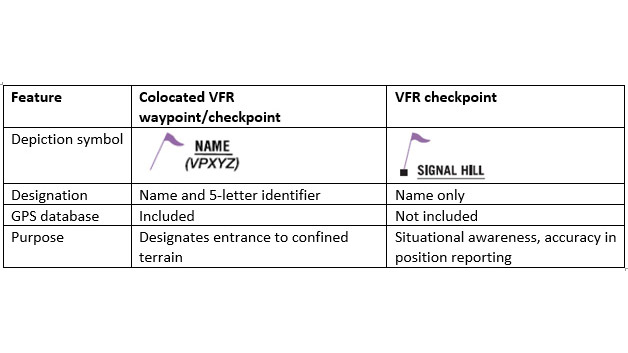
Mountain Passes
- VFR sectional charts depicted mountain passes to aid pilots in navigating difficult terrain. []
- According to the AOPA, two kinds of checkpoints are used, with slightly different elements:
- A collocated VFR waypoint/checkpoint is employed to designate entrance to confined terrain, such as a river valley or canyon.
- Depicted with the magenta flag symbol, these points have a name and a five-letter identifier (such as VPNUN) and may be found in a GPS database.
- Once inside confined terrain, however, only standard VFR checkpoints are used.
- These, also depicted with a magenta flag, have an identified pronounceable name but lack an identifier and are not included in the GPS database.
Mountain Flying Lessons & Case Studies
- National Transportation Safety Board Identification: LAX08FA043:
- The NTSB determines the probable cause(s) of this accident to be: The pilot's encounter with isolated moderate (or greater) turbulence, updrafts, and downdrafts associated with localized mountain wave conditions at low altitude and, his failure to maintain adequate airspeed during the encounter that resulted in an inadvertent accelerated stall.
Mountain Flying Knowledge Check


Mountain Flying Conclusion
- Your first experience of flying over mountainous terrain (particularly if most of your flight time has been over the flatlands of the midwest) could be a never-to-be-forgotten nightmare if proper planning is not done and if you are not aware of the potential hazards awaiting.
- Plan your route to avoid topography, which would prevent a safe forced landing.
- The route should be overpopulated areas and well-known mountain passes.
- Sufficient altitude should be maintained to permit gliding in the event of an engine failure.
- File a flight plan so ATC knows when and where to expect you.
- The AOPA offers posters to bring awareness to density altitude
- Approach mountain passes with as much altitude as possible; downdrafts are not uncommon on the leeward side.
- To learn more, check out AOPA's mountain flying course, Back Country Resource Center and Mountain Flying Quiz.
- Still looking for something? Continue searching:
Mountain Flying References
- AOPA - Charting Changes Highlight Mountain Passes.
- AOPA - Mountain Flying Safety Quiz.
- AOPA - Unpredictable.
- Federal Aviation Administration - Pilot/Controller Glossary.
- Aeronautical Information Manual (4-6-6) Guidance on Severe Turbulence and Mountain Wave Activity (MWA).
- Aeronautical Information Manual (7-6-7) Mountain Flying.
- Air Safety Foundation - Mountain Flying.
- FAA Safety Team - Mountain Flying.