Pilot Reports
Pilot reports are recorded meteorological phenomena encountered in real-time by pilots in flight, shared for the benefit of other pilots.
Introduction to Pilot Reports
- A Pilot Report (PIREP) is a report of meteorological phenomena encountered by the pilot in flight
- These reports serve as warnings to other pilots and give Air Traffic Control (ATC) knowledge of potential hazards to keep pilots clear
- All pilots should give reports if:
- In flight when requested
- When unusual or unforecast weather conditions are encountered
- When weather conditions on an IFR approach differ from the latest observation
- When a missed approach is executed due to weather.
- When a wind shear is encountered on departure or arrival
- PIREPS can relate to a variety of factors such as turbulence, airframe icing, volcanic ash, wind shear, and clear air turbulence.
Pilot Reports Key Highlights
- Pilot reports (PIREPs) provide real-time weather observations from pilots operating in actual flight conditions.
- PIREPs help pilots, air traffic control, and weather forecasters identify weather hazards not fully captured by automated systems.
- Common PIREP information includes location, altitude, aircraft type, sky condition, visibility, turbulence, icing, and weather phenomena.
- Urgent PIREPs report hazardous conditions such as severe turbulence, severe icing, low-level wind shear, volcanic ash, or other critical hazards.
- Routine PIREPs support weather awareness by reporting less severe but operationally useful conditions along routes of flight.
- Pilots should submit PIREPs when encountering conditions that differ from forecasts or may affect other aircraft operations.
- PIREPs improve aviation weather products by providing verification and updates for forecasts, advisories, and observed conditions.
- Air traffic control and Flight Service can receive and distribute PIREPs to support pilot decision-making and hazard avoidance.
- Accurate PIREP location, altitude, timing, and condition descriptions improve the usefulness of reported weather information.
- Understanding pilot reports improves weather interpretation, situational awareness, and overall flight safety.
Pilot Reports
- The submission of a PIREP can be initiated by both the pilot or an air traffic controller
-
Air Traffic Control:
- FAA air traffic facilities are required to solicit PIREPs when the following conditions are reported or forecast:
- Ceilings at or below 5,000'
- Visibility at or below 5 miles (surface or aloft)
- Thunderstorms and related phenomena
- Icing of light degree or greater
- Turbulence of moderate degree or greater
- Wind shear and reported or forecast volcanic ash clouds
- FAA air traffic facilities are required to solicit PIREPs when the following conditions are reported or forecast:
-
Pilots:
- Pilots are urged to cooperate and promptly volunteer reports of these conditions and other atmospheric data such as:
- Actual cloud bases, tops and layers
- Pilots can calculate cloud bases, but real-time data is of more fidelity than standard lapse rates.
- Flight visibility
- Precipitation
- Visibility restrictions such as haze, smoke and dust
- Wind at altitude
- Temperature aloft
- Actual cloud bases, tops and layers
- Pilots are urged to cooperate and promptly volunteer reports of these conditions and other atmospheric data such as:
- PIREPs should be given to the ground facility with which communications are established; i.e., FSS, ARTCC, or terminal ATC
- One of the primary duties of the Inflight position is to serve as a collection point for the exchange of PIREPs with en route aircraft
- If pilots are not able to make PIREPs by radio, reporting upon landing of the in-flight conditions encountered to the nearest AFSS/FSS or Weather Forecast Office will be helpful
- Some of the uses made of the reports are:
- The ATCT uses the reports to expedite the flow of air traffic in the vicinity of the field and for hazardous weather avoidance procedures
- The AFSS/FSS uses the reports to brief other pilots, to provide in-flight advisories, and weather avoidance information to en route aircraft
- The ARTCC uses the reports to expedite the flow of en route traffic, to determine most favorable altitudes, and to issue hazardous weather information within the center's area
- The NWS uses the reports to verify or amend conditions contained in aviation forecast and advisories. In some cases, pilot reports of hazardous conditions are the triggering mechanism for the issuance of advisories. They also use the reports for pilot weather briefings
- The NWS, other government organizations, the military, and private industry groups use PIREPs for research activities in the study of meteorological phenomena
- All air traffic facilities and the NWS forward the reports received from pilots into the weather distribution system to assure the information is made available to all pilots and other interested parties
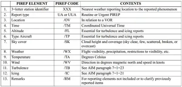
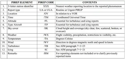
- The FAA, NWS, and other organizations that enter PIREPs into the weather reporting system use a standard format []
- Items 1 through 6 are included in all transmitted PIREPs along with one or more of items 7 through 13
- Although the PIREP should be as complete and concise as possible, pilots should not be overly concerned with strict format or phraseology
- The important thing is that the information is relayed so other pilots may benefit from your observation
- If a portion of the report needs clarification, the ground station will request the information
- Completed PIREPs will be transmitted to weather circuits as in the following examples
Example:
- KCMH UA /OV APE 230010/TM 1516/FL085/TP BE20/SK BKN065/WX FV03SM HZ FU/TA 20/TB LGT
- One zero miles southwest of Appleton VOR; time 1516 UTC; altitude eight thousand five hundred; aircraft type BE200; bases of the broken cloud layer is six thousand five hundred; flight visibility 3 miles with haze and smoke; air temperature 20°C; light turbulence
- KCRW UV /OV KBKW 360015-KCRW/TM 1815/FL120//TP BE99/SK IMC/WX RA/TA M08 /WV 290030/TB LGT-MDT/IC LGT RIME/RM MDT MXD ICG DURC KROA NWBND FL080-100 1750Z
- From 15 miles north of Beckley VOR to Charleston VOR; time 1815 UTC; altitude 12,000 feet; type aircraft, BE-99; in clouds; rain; temperature minus 8°C; wind 290° magnetic at 30 knots; light to moderate turbulence; light rime icing during climb northwest bound from Roanoke, VA, between 8,000 and 10,000 feet at 1750 UTC
- KCMH UA /OV APE 230010/TM 1516/FL085/TP BE20/SK BKN065/WX FV03SM HZ FU/TA 20/TB LGT
Issuance & Validity
- Issued when/as reports are received
- Valid for current conditions and contain no forecasted data
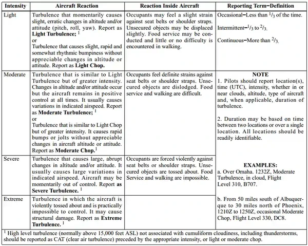
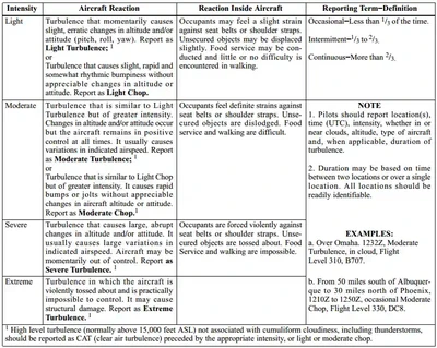
PIREPs Relating to Turbulence
- When encountering turbulence, pilots are urgently requested to report such conditions to ATC as soon as practicable
Turbulence PIREP Information:
- Aircraft location
- Time of occurrence in UTC
- Turbulence intensity []
- Whether the turbulence occurred in or near clouds
- Aircraft altitude or flight level
- Type of aircraft
- Duration of turbulence
- Example:
- Over Omaha, 1232Z, moderate turbulence in clouds at Flight Level three one zero, Boeing 707
- From five zero miles south of Albuquerque to three zero miles north of Phoenix, 1250Z, occasional moderate chop at Flight Level three three zero, DC8
- Duration and classification of intensity should be made in accordance with FAA guidance []
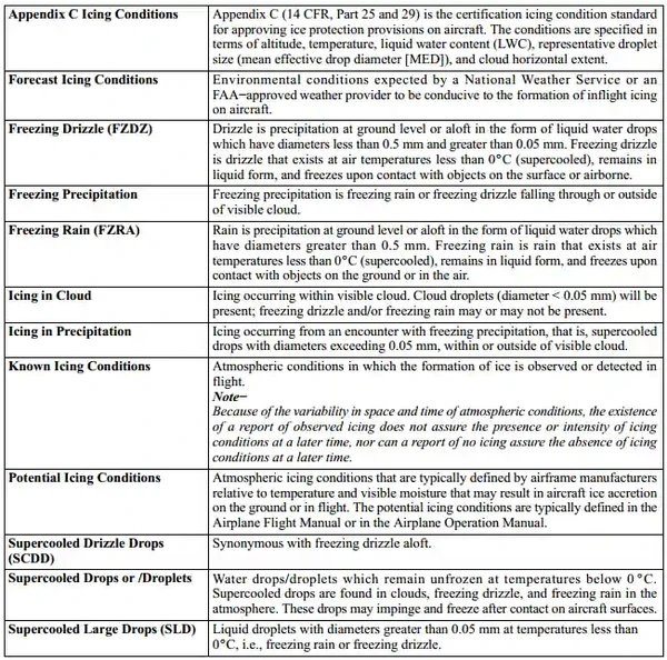
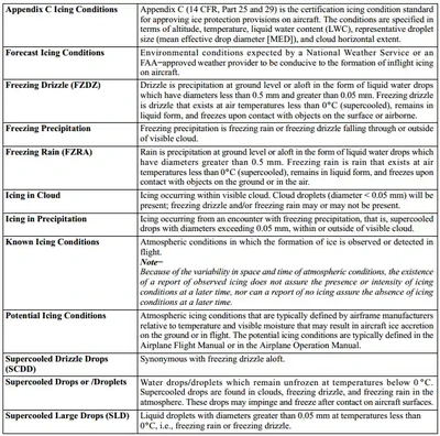
PIREPs Relating to Airframe Icing
- The effects of ice on aircraft are cumulative as thrust is reduced, drag increases, lift lessens, and weight increases
- The results are an increase in stall speed and a deterioration of aircraft performance
- In extreme cases, 2 to 3 inches of ice can form on the leading edge of the airfoil in less than 5 minutes
- It takes but 1/2 inch of ice to reduce the lifting power of some aircraft by 50% and increases the frictional drag by an equal percentage
- A pilot can expect icing when flying in visible precipitation, such as rain or cloud droplets, and the temperature is between +02 and -10° Celsius
- When icing is detected, a pilot should do one of two things, particularly if the aircraft is not equipped with deicing equipment; get out of the area of precipitation; or go to an altitude where the temperature is above freezing
- This "warmer" altitude may not always be a lower altitude
- Proper preflight action includes obtaining information on the freezing level and the above freezing levels in precipitation areas
- Report icing to ATC, and if operating IFR, request new routing or altitude if icing will be a hazard
- Be sure to give the type of aircraft to ATC when reporting icing
-
Reporting Icing Conditions:
- Trace: Ice becomes noticeable. The rate of accumulation is slightly greater than the rate of sublimation. A representative accretion rate for reference purposes is less than 1/4 inch (6 mm) per hour on the outer wing. The pilot should consider exiting the icing conditions before they become worse
- Light: The rate of ice accumulation requires occasional cycling of manual deicing systems to minimize ice accretions on the airframe. A representative accretion rate for reference purposes is 1/4 inch to 1 inch (0.6 to 2.5 cm) per hour on the unprotected part of the outer wing. The pilot should consider exiting the icing condition
- Moderate: The rate of ice accumulation requires frequent cycling of manual deicing systems to minimize ice accretions on the airframe. A representative accretion rate for reference purposes is 1 to 3 inches (2.5 to 7.5 cm) per hour on the unprotected part of the outer wing. The pilot should consider exiting the icing condition as soon as possible
- Severe: The rate of ice accumulation is such that ice protection systems fail to remove the accumulation of ice and ice accumulates in locations not normally prone to icing, such as areas aft of protected surfaces and any other areas identified by the manufacturer. A representative accretion rate for reference purposes is more than 3 inches (7.5 cm) per hour on the unprotected part of the outer wing. By regulation, immediate exit is required
- Severe icing is aircraft dependent, as are the other categories of icing intensity. Severe icing may occur at any ice accumulation rate when the icing rate or ice accumulations exceed the tolerance of the aircraft
- Example:
- Pilot: "[Agency], this is [Identification], [Location], [Time (UTC)], [Intensity of Type], [Altitude/FL], [Aircraft Type], [Indicated Air Speed (IAS)], and [Outside Air Temperature (OAT)]"
- Pilot: "Washington Center, this is N1727V, VORTAC, at 1800, experiencing trace icing at 10,000 feet, cessna 172, 120 knots, indicating -10 degrees C OAT"
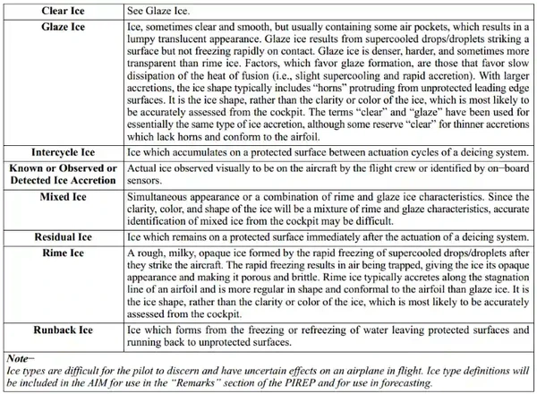
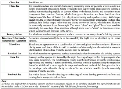
- Rime ice. Rough, milky, opaque ice formed by the instantaneous freezing of small supercooled water droplets
- Clear ice. A glossy, clear, or translucent ice formed by the relatively slow freezing of large supercooled water droplets
- The OAT should be requested by the AFSS/FSS or ATC if not included in the PIREP
PIREPs Relating to Volcanic Ash Activity
- Volcanic eruptions which send ash into the upper atmosphere occur somewhere around the world several times each year
- Flying into a volcanic ash cloud can be extremely dangerous
- Regardless of the type aircraft, some damage is almost certain to ensue after an encounter with a volcanic ash cloud
- Additionally, studies have shown that volcanic eruptions are the only significant source of large quantities of sulphur dioxide (SO2) gas at jet-cruising altitudes
- Therefore, the detection and subsequent reporting of SO2 is of significant importance
- Although SO2 is colorless, its presence in the atmosphere should be suspected when a sulphur-like or rotten egg odor is present throughout the cabin
- While some volcanoes in the U.S. are monitored, many in remote areas are not
- These unmonitored volcanoes may erupt without prior warning to the aviation community
- A pilot observing a volcanic eruption who has not had previous notification of it may be the only witness to the eruption
- Pilots are strongly encouraged to transmit a PIREP regarding volcanic eruptions and any observed volcanic ash clouds or detection of sulphur dioxide (SO2) gas associated with volcanic activity
- Pilots should submit PIREPs regarding volcanic activity using the Volcanic Activity Reporting (VAR) form
- If a VAR form is not immediately available, relay enough information to identify the position and type of volcanic activity
- Pilots should verbally transmit the data required in items 1 through 8 of the VAR as soon as possible. The data required in items 9 through 16 of the VAR should be relayed after landing if possible
PIREPS Relating to Clear Air Turbulence
- Clear Air Turbulence (CAT) has become a very serious operational factor to flight operations at all levels and especially to jet traffic flying in excess of 15,000'
- The best available information on this phenomenon must come from pilots via the PIREP reporting procedures
- All pilots encountering CAT conditions are urgently requested to report time, location, and intensity (light, moderate, severe, or extreme) of the element to the FAA facility with which they are maintaining radio contact
- If time and conditions permit, elements should be reported according to the standards for other PIREPs and position reports
Estimating Intensity of Rain and Ice Pellets
-
Rain Intensities:
-
Light Rain:
- From scattered drops that, regardless of duration, do not completely wet an exposed surface up to a condition where individual drops are easily seen
-
Moderate Rain:
- Individual drops are not clearly identifiable; spray is observable just above pavements and other hard surfaces
-
Heavy Rain:
- Rain seemingly falls in sheets; individual drops are not identifiable; heavy spray to height of several inches is observed over hard surfaces
-
-
Ice Pellet Intensities:
-
Light Ice Pellets:
- Scattered pellets that do not completely cover an exposed surface regardless of duration; Visibility not affected
-
Moderate Ice Pellets:
- Slow accumulation on ground. Visibility reduced by ice pellets to less than 7 statute miles
-
Heavy Ice Pellets:
- Rapid accumulation on ground. Visibility reduced by ice pellets to less than 3 statute miles
-
Estimating Intensity of Snow or Drizzle (Based on Visibility)
Light:
- Visibility more than 1/2 statute mile.
Moderate:
- Visibility from more than 1/4 statute mile to 1/2 statute mile.
Heavy:
- Visibility 1/4 statute mile or less.
Finding PIREPs
- PIREPs are available through ATC, Flight Service Stations, or AviationWeather.gov.
-
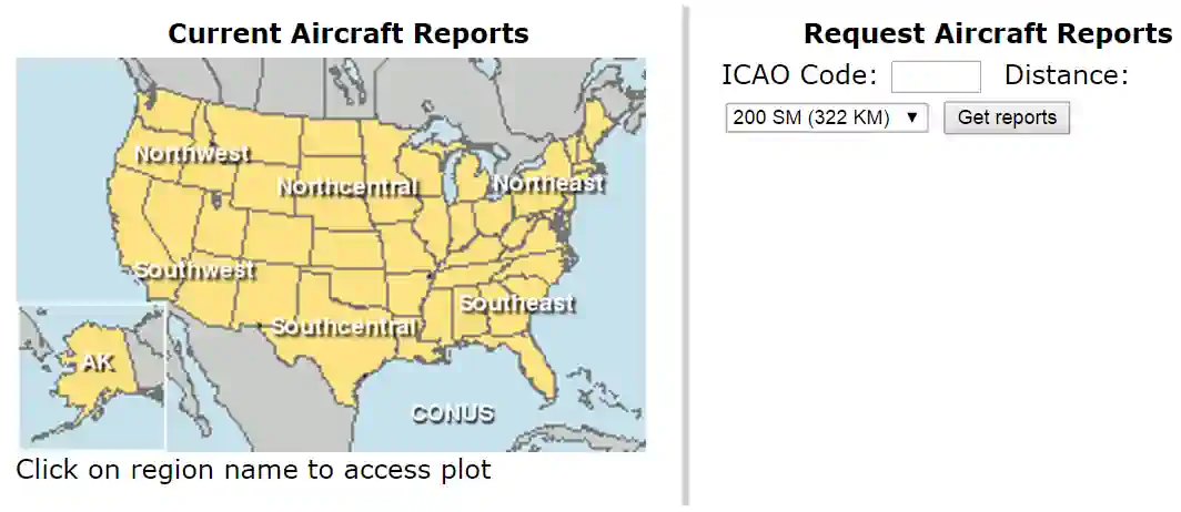
AviationWeather.gov PIREP Query
Submitting a PIREP
-
Radio PIREP Submission:
- When transmitting PIREPs manually, it is a good idea to write them out ahead of time with what you want to say.
- If you can't, or you omit something, its just a conversation, and need not be so formal and robotic when being read off.
- If you miss a critical piece of information, a controller will ask.
-
Electronic PIREP Submissions:
- The NTSB has recognized that difficulty in the PIREP submission process has resulted in few pilots submitting PIREPs
- There are many reasons to this which include: understanding, weather is as expected, or pilot workload (especially in adverse weather) including aviating and navigating
- See Aviation Weather.gov to register
- FAA InFO 14011 – Electronic Submission of Pilot Weather Reports.
Pilot Reports Knowledge Check


PIREP Lessons & Case Studies
- National Transportation Safety Board (NTSB) Identification: LAX05FA088:
- The NTSB determines the probable cause(s) of this accident to be: The pilot's in-flight loss of control following an inadvertent encounter with unforecast severe icing conditions. A factor in the accident was the inaccurate icing forecast developed by the NWS Aviation Weather Center
Pilot Reports Conclusion
- PIREPs are not just for pilots, and can influence other decisions such as weather reporting giving pilots a large amount of influence with even just a single PIREP.
- PIREPs are not just for adverse weather, and positive weather encountered is equally important to submit.
- Finally, PIREPs are often time critical events requiring submission in the moment.
- Case studies can show us that pilot reports have the potential to prevent accidents and loss of life.
- According to FAR 91.183, IFR Communications, aircraft operating under IFR must report any unforecast weather conditions encountered.
- According to AIM 5-3-3, Additional Reports, aircraft in general must report anything that pertains to safety of flight and when encountering weather conditions which have not been forecast, or hazardous conditions which have been forecast.
- For more information, a paper copy of Federal Aviation Administration (FAA-H-8083-28) Aviation Weather Handbook [Amazon] is available for purchase.
- A digital copy of Federal Aviation Administration (FAA-H-8083-28) Aviation Weather Handbook is available from the FAA's website.
- To learn more check out the AOPA's Sky Spotter Resources.
- Improve your weather skills with FAA provided (and WINGS credited) resources by going to https://www.faasafety.gov/ and type "weather" into the search bar.
- Still looking for something? Continue searching:
Pilot Reports References
- Federal Aviation Administration (FAA-H-8083-28) Aviation Weather Handbook.
- Federal Aviation Administration - Pilot/Controller Glossary.
- Aeronautical Information Manual (5-3-2) Position Reporting.
- Aeronautical Information Manual (5-3-3) Additional Reports.
- Aeronautical Information Manual (7-1-18) Pilot Weather Reports (PIREPs).
- Aeronautical Information Manual (7-1-19) PIREPs Relating to Airframe Icing.
- Aeronautical Information Manual (7-1-20) Definitions of Inflight Icing Terms.
- Aeronautical Information Manual (7-1-21) PIREPs Relating to Turbulence.
- Aeronautical Information Manual (7-1-22) Wind Shear PIREPs.
- Aeronautical Information Manual (7-1-23) Clear Air Turbulence (CAT) PIREPs.
- Aeronautical Information Manual (7-1-25) PIREPs Relating to Volcanic Ash Activity.
- Federal Aviation Regulations (91.183) IFR Communications.
- FAASTeam Notice (NOTC9911) Pay it Forward with PIREPs.
- FAA Safety Briefing (Tom Hoffmann) How to Be a Weather Wingman.
- NTSB Safety Alert - Pilot Weather Reports (PIREPs): Pay It Forward.
- FAA Information for Operators - Electronic Submission of Pilot Weather Reports (PIREP).
- Volcanic Activity Reporting (VAR).
- AOPA - ATC Wants Your 'PIREPS.' Really.