Air Masses & Weather Fronts
Fronts named according to the relative temperature of advancing air are boundary layers between air masses where weather occurs.
Introduction to Air Masses & Weather Fronts
- Fronts are the boundary layer between air masses (where weather happens)
- Fronts are named according to the temperature of the advancing air, relative to the air it is replacing
- The word 'front' came about during WWI during the times of trench warfare where the two opposing fronts came out and battled, similar to how the two air masses battle in a weather front
Air Masses & Weather Fronts Key Highlights
- Air masses are large bodies of air with relatively uniform temperature and moisture characteristics that influence aviation weather conditions.
- Weather fronts form where different air masses meet and commonly produce changing winds, clouds, precipitation, turbulence, and visibility conditions.
- Cold fronts often produce rapidly changing weather, convective activity, turbulence, and gusty surface winds.
- Warm fronts commonly create widespread cloud layers, reduced visibility, steady precipitation, and prolonged IFR conditions.
- Stationary fronts may produce extended periods of clouds, precipitation, and variable weather along frontal boundaries.
- Occluded fronts combine characteristics of warm and cold fronts and are often associated with complex weather systems.
- Air mass characteristics influence atmospheric stability, cloud formation, icing potential, and thunderstorm development.
- Pilots should evaluate frontal movement, temperature changes, wind shifts, and pressure trends during weather planning.
- Surface analysis charts, prognostic charts, METARs, TAFs, and radar imagery help identify air mass and frontal weather patterns.
- Understanding air masses and weather fronts improves weather interpretation, flight planning, and overall aeronautical decision-making.
Air Mass
- Uniform temperature moisture
- Classified by temperature on surface relative
- 4 discontinuities between Air masses:
- Temperature
- Dew Point
- Wind
- Pressure
Weather Fronts
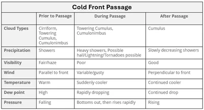
- The severity of the clouds and precipitation occurring along a front are dependent on:
- The amount of moisture available (shown by the dew point)
- The degree of stability of the lifted air
- The slope of the front
- The speed of the frontal movement
- The contrast in the amounts of temperature and moisture between the two air masses
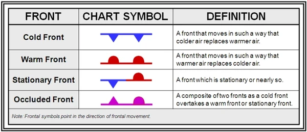
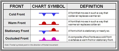
- There are four types of fronts: []
- Cold fronts, depicted in blue with triangles protruding in the direction of movement
- Warm fronts, depicted in red with half circles protruding in the direction of movement
- Stationary fronts, depicted in blue and red with opposing red half circles and blue triangles
- Occluded fronts, depicted in pink with half circles and blue triangles protruding in the direction of movement
-
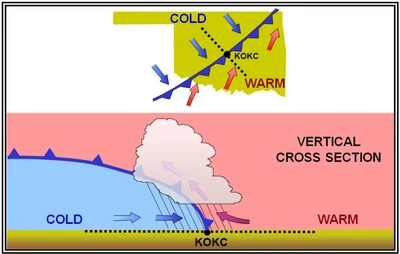
Cold Front:
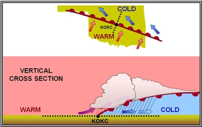
- A cold front is a body of cold, dense, and stable air overtaking and replacing warmer air
- It is so dense, it stays close to the ground and acts like a snowplow, sliding under the warmer air and forcing the less dense air aloft []
- Cold fronts have a steep slope, and the warm air is forced upward abruptly
- This often leads to a narrow band of showers and thunderstorms along, or just ahead of, the front if the warm rising air is unstable
- The rapidly ascending air causes the temperature to decrease suddenly, forcing the creation of clouds
- The type of clouds that form depends on the stability of the warmer air mass
- A cold front in the Northern Hemisphere is normally oriented in a northeast to southwest manner and can be several hundred miles long, encompassing a large area of land
- Cold fronts typically move at a faster rate than warm fronts (~25-30 mph)
- Extreme cold fronts have been recorded moving at speeds of up to 60 mph
- Cold fronts tend to move faster in the summer than in winter
- Movement is usually eastern while the front is usually a NE-SW line
- Precipitation always falls in front of a cold front
- Fast Moving Cold Fronts:
- Fast-moving cold fronts are pushed by intense pressure systems far behind the actual front
- As surface friction slows a front, the leading edge tends to bulge out and steepen the front's slope
- This results in a very narrow band of weather, concentrated along the leading edge of the front
- If the warm air being overtaken by the cold front is relatively stable, overcast skies and rain may occur for some distance behind the front
- If the warm air is unstable, scattered thunderstorms and rain showers may form. A continuous line of thunderstorms, or squall line, may form along or ahead of the front
- Squall lines present a serious hazard to pilots as squall-type thunderstorms are intense and move quickly
- Behind a fast-moving cold front, the skies usually clear rapidly, and the front leaves behind gusty, turbulent winds and colder temperatures
- Squal Lines:
- Squal lines are the result of two airmasses colliding
- Intensity is relative to the speed and difference between the airmasses, with highly diverse airmasses potentially colliding at ~50 knot speeds
- Weather products that mention potential for squall lines include:
- Convective outlooks and mesoscale products from the Storm Prediction Center website (spc.noaa.gov) will certainly mention their probability, as will convective sigmets on the Aviation Weather Center website (aviationweather.gov)
- Weather imagary/radar displays squall lines as thin red or magenta lines
- Squal lines are the result of two airmasses colliding
- Slow Moving Cold Fronts:
- Less than 15 knots
- More like a warm front in properties and weather
-
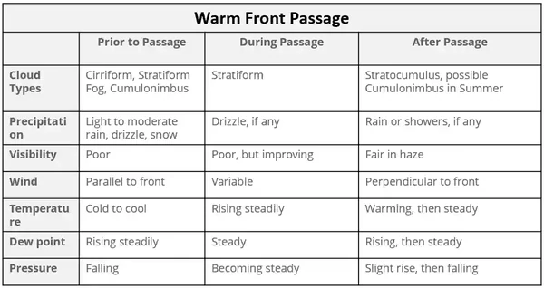
Warm Fronts:
- A warm front is a body of warm air overtaking and replacing cooler air
- Warm fronts typically move at a slower rate than cold fronts (~10-25 mph)
- The slope of the advancing front slides over the top of the cooler air and gradually pushes it out of the area
- Warm fronts typically have a gentle slope, so the warm air rising along the frontal surface is gradual []
- This favors the development of widespread layered or stratiform cloudiness and precipitation along, and ahead of, the front if the warm rising air is stable
- In the summer months, cumulonimbus clouds (thunderstorms) are likely to develop
-
Stationary Front:
- When the forces of two air masses are relatively equal, the boundary or front that separates them remains stationary and influences the local weather for days
- Less than 5 knots of movement
- Winds blow 180° off from one another on each side
- Weather in a stationary front is a mix of cold and warm front characteristics
- Stationary frontal slope can vary, but clouds and precipitation would still form in the warm rising air along the front
- Wind blows parallel to fronts, but opposite directions to one another
- When the forces of two air masses are relatively equal, the boundary or front that separates them remains stationary and influences the local weather for days
-
Occluded Front:
- Occurs when a fast-moving cold front catches up to a slow-moving warm front
- The temperature within each front is the primary determinant as to the type of front/weather to be expected
- Cause persistent weather lasting over 24 hours
- Classified cold or warm based on what is in contact with the ground
-
Cold Front Occlusion:
- A cold occlusion results when the coldest air is behind the cold front
- The cold air replaces the cooler air at the surface and forces the warm air aloft
- High potential for serious weather
-
Warm Front Occlusion:
- Warm occlusion results when the coldest air is ahead of the warm front
- The cold air forces the cooler air of the advancing front aloft


Air Masses & Weather Fronts Knowledge Check


Air Masses & Weather Fronts Conclusion
- Note that frontal passage can be across hundreds of miles with the different temperature impacting cabin air temperatures as an aircraft climbs or descends through different temperature layers
- For more information, a paper copy of Federal Aviation Administration (FAA-H-8083-28) Aviation Weather Handbook [Amazon] is available for purchase
- A digital copy of Federal Aviation Administration (FAA-H-8083-28) Aviation Weather Handbook is available from the FAA's website
- Looking for more? Check out the AOPA's Aircraft Owners and Pilot's Association - Weather Wise: Air Masses and Fronts.
- Improve your weather skills with FAA provided (and WINGS credited) resources by going to https://www.faasafety.gov/ and type "weather" into the search bar
- Still looking for something? Continue searching: