Turbulence
Aircraft experience turbulence due to the irregular motion of an aircraft in flight as caused by various environmental conditions.
Introduction to Turbulence
- Tubulence is an atmospheric phenomenon that causes changes in aircraft altitude, attitude, and or airspeed with aircraft reaction depending on intensity. Pilots report turbulence intensity according to aircraft's reaction
- Turbulence comes in several forms, identified by its source
- Aircraft experience turbulence in varying intensities due to the irregular motion of an aircraft in flight, especially when characterized by rapid up-and-down motion caused by a rapid variation of atmospheric wind velocities
- Turbulence is caused by convective currents (called convective turbulence), obstructions in the wind flow (called mechanical turbulence), and wind shear
- Turbulence varies from annoying bumpiness to severe jolts, which cause structural damage to an aircraft and/or injury to its passengers
- The effect of turbulence varies based on the size of the aircraft
Turbulence Key Highlights
- Turbulence is irregular air motion that can affect aircraft control, passenger comfort, and structural loading during flight.
- Common turbulence sources include convective activity, terrain, wind shear, jet streams, frontal systems, and wake turbulence.
- Clear air turbulence can occur without visible clouds and is often associated with strong wind gradients near jet streams.
- Mechanical turbulence develops when wind flows over terrain, buildings, trees, or other surface obstructions.
- Convective turbulence near thunderstorms can be severe and may extend well beyond visible precipitation or cloud boundaries.
- Pilots should use weather briefings, SIGMETs, AIRMETs, PIREPs, and onboard weather tools to identify turbulence hazards.
- Reducing to maneuvering speed or turbulence penetration speed helps limit structural stress during rough air encounters.
- Seat belt use and passenger briefings reduce injury risk when turbulence is expected or encountered unexpectedly.
- Turbulence intensity reports help other pilots and forecasters understand current flight conditions along routes and altitudes.
- Understanding turbulence improves weather decision-making, aircraft handling, passenger safety, and overall flight safety.
Types of Turbulence
-
Mechanical Turbulence:
- Mechanical turbulence is turbulence caused by obstructions to the wind flow, such as trees, buildings, mountains, and so on
- Obstructions to the wind flow disrupt smooth wind flow into a complex snarl of eddies
- Can form in stable or unstable air
- Presents landing hazards
- The intensity of mechanical turbulence depends on wind speed and roughness of the obstructions
- The wind carries the turbulent eddies downstream. How far depends on wind speed and stability of the air
- Unstable air allows larger eddies to form than those that form in stable air; but the instability breaks up the eddies quickly, while in stable air they dissipate slowly
- Mechanical turbulence is turbulence caused by obstructions to the wind flow, such as trees, buildings, mountains, and so on
-
Mountain Wave:
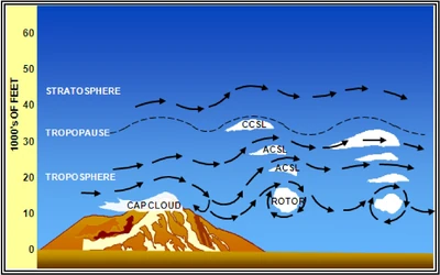
- A mountain wave is an atmospheric wave disturbance formed when stable air flow passes over a mountain or mountain ridge, producing hazardous wind conditions []
- The waves may extend 600 miles (1,000 kilometers) or more downwind from the mountain range
- Mountain waves frequently produce severe to extreme turbulence
- Location and intensity varies with wave characteristics
- Mountain waves often produce violent downdrafts on the immediate leeward side of the mountain barrier, sometimes exceeding maximum aircraft climb rates
- Up/downdrafts increase as wind speed increases
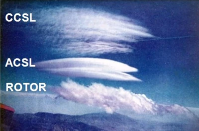
- A mountain wave cloud is a cloud that forms in the rising branches of mountain waves and occupies the crests of the waves
- The most distinctive are the sharp-edged, lens-, or almond-shaped lenticular clouds
- When sufficient moisture is present in the upstream flow, mountain waves produce interesting cloud formations including: cap clouds, cirrocumulus standing lenticular (CCSL), Altocumulus Standing Lenticular (ACSL), and rotor clouds []
- These clouds provide visual proof that mountain waves exist
- However, these clouds may be absent if the air is too dry
- Stable air and wind speeds between 25-40 knots foster turbulence
-
Clear Air Turbulence:
- Typically above 15,000 and in vicinity to the jet steam
- Drastic changes in wind speed and velocity
-
Frontal Turbulence:
- Occurs in a narrow zone, just ahead of a fast-moving cold front
- Updrafts of 1,000 FPM, with significant turbulence
-
Thunderstorm Turbulence:
- Thunderstorms produce extreme up and downdrafts that can be felt for miles away from a storm
- Due to the extreme weather found in thunderstorms, up/down drafts of 6,000 feet per minute may be encountered
- Turbulence risk increases above 10,000 feet due to rapid vertical development
-
Temperature Inversion Turbulence:
- Temperature inversions are when temperatures rise with altitude gained
- In the boundary where cold and warm air meet, temperature inversion turbulence may be found
-
Thermal (Convective) Turbulence:
- Convective turbulence is turbulent vertical motions that result from convective currents and the subsequent rising and sinking of air
- Low altitude, with updrafts 200-2,000 FPM
- For every rising current, there is a compensating downward current
- The downward currents frequently occur over broader areas than do the upward currents; therefore, they have a slower vertical speed than do the rising currents
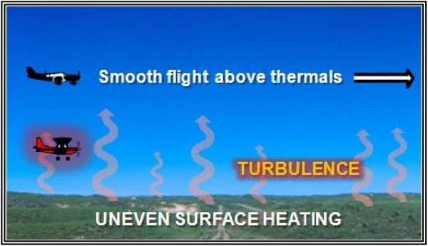
- Convective currents are most active on warm summer afternoons when winds are light
- Heated air at the surface creates a shallow, absolutely unstable layer within which bubbles of warm air rise upward
- Convection increases in strength and to greater heights as surface heating increases
- Barren surfaces such as sandy or rocky wastelands and plowed fields become hotter than open water or ground covered by vegetation
- Thus, air at and near the surface heats unevenly
- Because of uneven heating, the strength of convective currents can vary considerably within short distances
- Typically short distance, with possibly severe turbulence below the clouds
- Varies widely with terrain
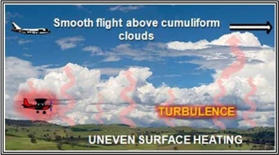
- As air moves upward, it cools by expansion
- A convective current continues upward until it reaches a level where its temperature cools to the same as that of the surrounding air
- If it cools to saturation, a cumuliform cloud forms
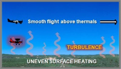
- Billowy cumuliform clouds, usually seen over land during sunny afternoons, are signposts in the sky indicating convective turbulence [Figure 7]
- The cloud top usually marks the approximate upper limit of the convective current
- A pilot can expect to encounter turbulence beneath or in the clouds, while above the clouds, air generally is smooth
- When convection extends to great heights, it develops larger towering cumulus clouds and cumulonimbus with anvil-like tops
- The cumulonimbus gives visual warning of violent convective turbulence
- When the air is too dry for cumuliform clouds to form, convective currents can still be active
- This is called dry convection, or thermals [Figure 8]
- A pilot has little or no indication of their presence until encountering the turbulence
- Surfaces such as roads or homes radiant heat while surfaces such as farms or water absorb radiant heat
-
Wake Turbulence:
- Wake turbulence is a function of an aircraft producing lift, creating a vortex that forms two counter-rotating vortices trailing behind the aircraft is the distrubance of airflow caused by the wake left behind from a surface


Turbulence Intensities
- Turbulence is classified by its intensity:
-
Light Turbulence:
- Causes slight, erratic changes in altitude and/or attitude (pitch, roll, or yaw). Report as Light Turbulence. Or causes slight, rapid, and somewhat rhythmic bumpiness without appreciable changes in altitude or attitude. Report as Light Chop
-
Moderate Turbulence:
- Similar to Light but of greater intensity. Changes in altitude and/or attitude occur but the aircraft remains in positive control at all times. It usually causes variations in indicated airspeed. Report as Moderate Turbulence. Or turbulence that is similar to Light Chop but of greater intensity. It causes rapid bumps or jolts without appreciable changes in aircraft altitude or attitude. Report as Moderate Chop
-
Severe Turbulence:
- Causes large, abrupt changes in altitude and/or attitude. It usually causes large variations in indicated airspeed. Aircraft may be momentarily out of control
-
Extreme Turbulence:
- The aircraft is violently tossed about and is practically impossible to control. It may cause structural damage
-
Turbulence Reports and Forecasts
- Turbulence reports can be found through pilot reports.
- Turbulence forecasts are available at the Aviation Weather Center.
Turbulence Avoidance
- Common sense, like high-altitude and mountainous terrain can expect turbulence in high wind days
- If flying at lower altitudes, flying early in the morning or in the evening, avoiding the 1pm - 5pm period of higher thermal turbulence risk
- In less obvious situations, tools like SkyPath can provide a path through atmospheric acitivity
- NOAA's Eddy Dissipation Rate (EDR) also helps predict turbulent flow in the atmosphere
Penetrating Turbulence
- Turbulence may be unavoidable, or unforeseen
- When encountering turbulence, pilots may penetrate by flying Va, maneuvering speed.
- If published, Vb or Vo provide more precise solutions, and are generally 10-20 knots lower than Va
- Pilots should trim for at or below maneuvering speed, accepting variations in altitude and airspeed will occur throughout, but that the aircraft will trend back toward it's trimmed state.
- Keeping the wings level will reduce wing loading.
- The appropriate V-speed provides protection from rapid changes in AOA, related to, but not directly the "full control surface deflection" quoted by maneuvering speed
Turbulence Knowledge Check


Turbulence Lessons & Case Studies
- National Transportation Safety Board (NTSB) Identification: DCA23LA213:
- The NTSB determines the probable cause(s) of this accident to be: An encounter with forecast convective turbulence during climb
Turbulence Conclusion
- Realize reported turbulence is relative to the aircraft
- What may be light to some may be moderate or extreme to others
- For more information, a paper copy of Federal Aviation Administration (FAA-H-8083-28) Aviation Weather Handbook [Amazon] is available for purchase
- A digital copy of Federal Aviation Administration (FAA-H-8083-28) Aviation Weather Handbook is available from the FAA's website
- Improve your weather skills with FAA provided (and WINGS credited) resources by going to https://www.faasafety.gov/ and type "weather" into the search bar
- Still looking for something? Continue searching: