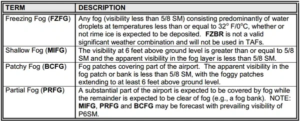
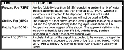
Obstructions To Visibility
The aviation environment is fraught with obstructions to visibility as a result of atmospheric processes.
Introduction to Obstructions To Visibility
- Obstructions to visibility degrade or prevent pilots from easily identifying the horizon or other hazards to flight
- Fog is nothing more than a low cloud, which has its base within 50' of the ground
Obstructions To Visibility Key Highlights
- Obstructions to visibility reduce a pilot’s ability to see terrain, traffic, runways, and visual navigation references.
- Common visibility obstructions include fog, mist, haze, smoke, dust, sand, precipitation, snow, and blowing debris.
- Reduced visibility can affect VFR weather minimums, approach planning, traffic avoidance, and landing decisions.
- Fog forms when air near the surface becomes saturated and can rapidly reduce airport visibility below VFR minimums.
- Haze and smoke can obscure terrain and horizon references while still allowing some forward visibility.
- Precipitation such as rain, snow, or drizzle may reduce visibility and contribute to runway contamination or icing hazards.
- Blowing dust, sand, or snow can create localized visibility reductions during surface winds or convective outflow events.
- Pilots should compare METARs, TAFs, PIREPs, weather cameras, and updated advisories when visibility is marginal or changing.
- Loss of visual references can lead to spatial disorientation, controlled flight into terrain, or inadvertent VFR flight into IMC.
- Understanding obstructions to visibility improves weather interpretation, risk management, and overall flight safety.
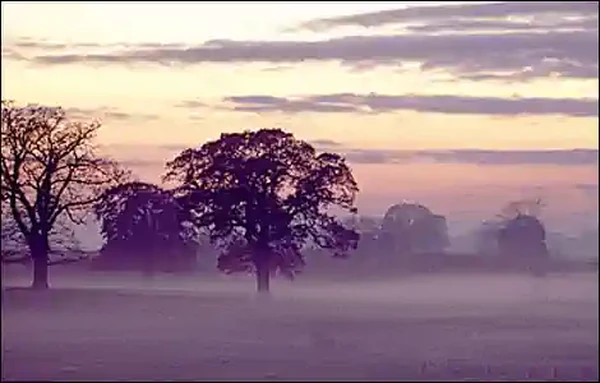
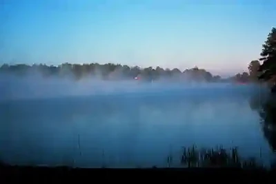
Fog
- Fog is nothing more than a low cloud, which has its base within 50' of the ground, reducing visibility to less than 5/8 Statute Miles (SM)
- Fog forms and is therefore dependent on the air becoming temporarily supersaturated
- Air containing more moisture than it can hold for that temperature
- Excess moisture then condenses resulting in fog
- Fog can be extremely important to a pilot, especially when flying to an unfamiliar region
- Fog is classified by how it forms.
- When operating in flat light/brown out/whiteout conditions, special condsiderations apply
- Pilots must be prepared for a loss of visual references.
- Fog its own challenge, but landing in low light conditions increase the hazard
-
Fog Formation:
- Fog forms and is therefore dependent on the air becoming temporarily supersaturated, that is:
- Air containing more moisture than it can hold for that temperature
- Excess moisture then condenses resulting in fog
- Fog is often associated with cool (or cooling) temperatures, because cool temperatures provide the best conditions to condensate (i.e., temperature drops toward the dew point).
- In order for fog to form, 3 basic conditions are required:
- Condensation nuclei (dust, dirt, pollen, etc.) must be present for moisture to condense on
- The air must have a high water content (low temperature/dew point spread)
- Occurs by cooling air to dew point or adding moisture to the air
- Fog will form when temperature and dew point are about 5°F/2°C within one another
- Light surface winds must be present
- Winds cause surface friction to cause an eddy causing more air to contact the ground
- High winds will lift the layer away from the ground
- Fog forms and is therefore dependent on the air becoming temporarily supersaturated, that is:
-
Types of Fog:
- Fog is classified by how it forms and is most often broken into five types:
-
Radiation (Ground) Fog:
- Radiation, also know as ground fog, forms over low-lying flat surfaces on clear, calm, humid nights. []
- Typically extends less than 20' off the ground
- As the surface cools by radiation, the adjacent air also is cooled to its dew point
- Cloudy nights reflect terrestrial radiation back to the death reducing cooling through a "blanket" effect would prevent formation
- Radiation fog actually occurs when the max temperature is reached
- Winds 5 to 10 knots result in dense fog while just 5 knots is shallow fog
- Fog will dissipate due to winds greater than 10 knots or solar heating
- Surface temperature must rise in order for the fog to clear and so thick layers will last longer as it takes longer to heat the ground
-
Advection Fog:
- Advection fog occurs when a low layer of warm, moist air moves over a cooler surface
- Some wind velocity is required for formation and in fact, the fog becomes thicker and denser as wind speed increases up to about 15 knots
- Stronger winds lift moisture into low stratus clouds
- Fog can stay over water for weeks, moving over land late in the day and back over the water the next morning
- Generally, there are two scenarios which lend to the formation of advection fog:
- Cold water rising from the depths to the surface cooling the air above it (i.e., the pacific)
- Tropical air moving over cold ground (i.e., the gulf coast)
- Solar radiation generally cannot penetrate the thickness to warm the Earth sufficiently and so wind is required to push air from a cold surface to a warm surface, reversing the saturation process
- Especially due to the high specific heat of water.
-
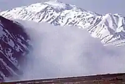
Upslope Fog:
- Forms when moist, stable air is forced up a sloping land mass to a level where the air becomes saturated and condensation occurs. []
- Requires wind for formation
- This type of fog usually forms a good distance from the peak of the hill or mountain and covers a large area
- Upslope fog occurs in all mountain ranges in North America
- This usually occurs during the winter months, when cold air behind a cold front drifts westward and encounters the eastward facing slopes of the Rocky Mountains
- As the cold, moist air rises up the slopes of the mountains, condensation occurs and extensive areas of fog form on the lower slopes of the mountains
-
Evaporation Fog:
- This type of fog forms when sufficient water vapor is added to the air by evaporation and the moist air mixes with cooler, relatively drier air
- There are two common types of evaporation fog:
-
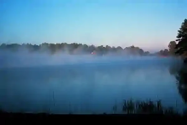
Steam Fog:
- Steam fog, also called steaming fog or valley fog, forms when cold air moves over warm water
- When the cool air mixes with the warm moist air over the water, the moist air cools until its humidity reaches 100% and fog forms
- This type of fog takes on the appearance of wisps of smoke rising off the surface of the water giving it the nickname "seasmoke". []
- Can occur opposite of upslope fog as cool air sinks into warmer moist air.
-
Frontal Fog:
- This type of fog forms when warm raindrops evaporate into a cooler drier layer of air near the ground
- Once enough rain has evaporated into the layer of cool surface, the humidity of this air reaches 100% and fog forms.
-
-
Ice Fog:
- Occurs in cold weather when the temperature is much below freezing and water vapor sublimates directly into ice crystals. []
- Conditions for formation are the same as radiation fog except for cold temperature, 25°F and colder
- Occurs mostly in arctic regions
- Can be blinding to someone flying into the sun


Mist
- Mist is a visible aggregate of minute water droplets or ice crystals suspended in the atmosphere that reduces visibility to less than 7 sm (11 km), but greater than, or equal to, 5/8 sm (1 km). Mist forms a thin grayish veil that covers the landscape. It is similar to fog, but does not obstruct visibility to the same extent. Mist may be considered an intermediate between fog and haze. It has lower relative humidity (95 to 99 percent) than fog and does not obstruct visibility to the same extent. However, there is no distinct line between any of these categories
Haze
- Haze is a suspension in the air of extremely small particles invisible to the naked eye and sufficiently numerous to give the air an opalescent appearance. It reduces visibility by scattering the shorter wavelengths of light. Haze produces a bluish color when viewed against a dark background and a yellowish veil when viewed against a light background. Haze may be distinguished by this same effect from mist, which yields only a gray obscuration. Certain haze particles increase in size with increasing relative humidity, drastically decreasing visibility. While visibility is a measure of how far one can see, including the ability to see the textures and colors therein, haze is the inability to view a similar scene with equal clarity
- Haze occurs in stable air and is usually only a few thousand feet thick, but may extend upwards to 15,000 ft (4,600 m). A haze layer has a definite ceiling above which in-flight (air-to-air) visibility is unrestricted. At or below this level, the slant range (air-to-ground) visibility is poor. Visibility in haze varies greatly, depending on whether the pilot is facing into or away from the Sun
Smoke
- Smoke is a suspension in the air of small particles produced by combustion due to fires, industrial burning, or other sources. It may transition to haze when the particles travel 25 to 100 mi (40 to 160 km) or more, and the larger particles have settled and others become widely scattered through the atmosphere. Not only can smoke reduce visibility to zero, but many of its compounds are highly toxic and/or irritating. The most dangerous is carbon monoxide, which can lead to carbon monoxide poisoning, sometimes with supporting effects of hydrogen cyanide and phosgene
- When skies are clear above a surface-based layer of haze or smoke, visibility generally improves during the day. Heating during the day may cause convective mixing, spreading the smoke or haze to a higher altitude, and decreasing the concentration near the surface. However, the improvement is slower than the clearing of fog. Fog evaporates, but haze and smoke must be dispersed by the movement of air. A thick layer of clouds above haze or smoke may block sunlight, preventing dissipation. Visibility will improve little, if any, during the day
Precipitation
- Precipitation is any of the forms of water particles, whether liquid or solid, that fall from the atmosphere and reach the ground. Snow, rain, and drizzle are types of precipitation. Heavy snow may reduce visibility to zero. Rain seldom reduces surface visibility below 1 mi except in brief, heavy showers. Drizzle usually restricts visibility to a greater degree than rain. It forms in stable air, falls from stratiform clouds, and is typically accompanied by fog. When drizzle changes to light rain, visibility usually improves because the droplet size increases, meaning there are fewer droplets per unit area
- For more information on precipitation, see Chapter 14, Precipitation
Blowing Snow
- Blowing snow is snow lifted from the surface of the Earth by the wind to a height of 6 ft (2 m) or more above the ground, and blown about in such quantities that the reported horizontal visibility is reduced to less than 7 sm (11 km). Light, dry powder snow is most prone to being blown by the wind. When strong winds keep the snow suspended up to 50 ft (15 m) or so, obscuring the sky, and reducing surface visibility to near zero, it is called a whiteout. Visibility improves rapidly when the wind subsides
Dust Storms
- A dust storm is a severe weather condition characterized by strong winds and dust-filled air over an extensive area. Dust storms originate over regions when fine-grained soils, rich in clay and silt, are exposed to strong winds and lofted airborne. Fine-grained soils are commonly found in dry lake beds (called playas), river flood plains, ocean sediments, and glacial deposits
- Most of the dust originates from a number of discrete point sources. Intense dust storms reduce visibility to near zero in and near source regions, with visibility improving away from the source
- A dust storm is favored with extreme daytime heating of barren ground and a turbulent, unstable air mass that allows the dust to be lofted. Surface winds need to be 15 kt or greater to mobilize dust. A speed of 35 kt may be needed over a desert surface that is covered with closely packed rock fragments called desert pavement. The average height of a dust storm is 3,000 to 6,000 ft (about 1 km); however, they can frequently extend up to 15,000 ft (4,600 m)
- Strong cooling after sunset quickly stabilizes the lowest atmosphere, forming a temperature inversion and settling the dust. Without turbulence, dust generally settles at a rate of 1,000 ft (300 m) per hour. It can take many hours (or days) for the dust to completely settle. However, precipitation will very effectively remove dust from the atmosphere
- Aircraft operation in a dust storm can be very hazardous. Visibility can drop to zero in a matter of seconds. Dust can also clog the air intake of engines, damage electro-optical systems, and cause problems with human health
- From a pilot's point of view, it is important to recognize that slant range (air-to-ground) visibility (see Figure 24-3) in dust is generally reduced compared to reported surface (horizontal) visibility. Therefore, it may not be possible to pick out an airfield from above, even when reported surface visibility is 3 mi or more
Sandstorms
- A sandstorm is particles of sand carried aloft by a strong wind. The sand particles are mostly confined to the lowest 10 ft (3.5 m), and rarely rise more than 50 ft (15 m) above the ground. Sandstorms are similar to dust storms, but occur on a localized scale. This is because sand particles are larger and heavier than dust particles. Sandstorms are best developed in desert regions where there is loose sand, often in dunes, without much admixture of dust
Haboobs
- A haboob (see Figure 18-11) is a dust storm or sandstorm that forms as cold downdrafts from a thunderstorm turbulently lift dust and sand into the air. While haboobs are often short-lived, they can be quite intense. The dust wall may extend horizontally for more than 60 mi (100 km) and rise vertically to the base of the thunderstorm. Spinning whirlwinds of dust frequently form along the turbulent cold air outflow, giving rise to huge dust/sand whirls
Volcanic Ash
- Volcanic ash is made up of fine particles of rock powder that originate from a volcano and that may remain suspended in the atmosphere for long periods. Severe volcanic eruptions that send ash into the upper atmosphere occur somewhere around the world several times per year. The explosive eruption from the volcano in Tonga, South Pacific Ocean in January 2022 sent an ash cloud into the mesosphere. Weather satellites estimated the ash cloud reached an altitude of 190,000 ft, which was the highest ash cloud ever observed
- Visible ash is what an observer or aircrew member sees with their eyes. The lower limit of visible ash ranges from an ash concentration of approximately 0.01 milligrams per cubic meter (mg/m3 ) to 10 mg/m3, depending on many factors such as time of day, sky background, and position of the sun to the observer (pilot), as well as the angle from which the ash cloud is viewed (e.g., viewed from the side)
- Discernible ash is what a satellite or other remote sensing instrument detects. Forecasters at the world's nine VAACs (see Section 26.5.1) use discernible ash from satellites to define the observed area of the ash cloud in the VAA product (see Section 26.5). The lower limit of discernible ash from satellites is approximately 0.1 to 0.2 mg/m3, depending on the satellite and other factors
- The ash cloud may not be visible, especially at night or in instrument meteorological conditions (IMC). Even if visible, it is difficult to distinguish visually between an ash cloud and an ordinary cloud. Radar may be able to detect heavy concentrations of airborne ash near the volcano, but is not able to detect fine airborne ash, and is not likely to detect the ash cloud as it spreads downwind of the volcano
- Flying into a volcanic ash cloud can be hazardous. Volcanic ash is composed of silica (glass). When ash is ingested into a jet engine, it melts to produce a soft, sticky molten product that adheres to the compressor turbine blades and fuel injectors/igniters. With no air going into the engine, the fuel cannot ignite, the engine comes to a slow spinning stop by spooling down, and a flameout occurs. As the aircraft exits the ash cloud and enters colder temperatures, the cooled, hardened silicas on the turbine blades become dislodged, allowing the fan blades to rotate, and allowing for an engine relight as the air moves through the engine again. Piston-powered aircraft are less likely to lose power, but severe engine damage is likely after an encounter with a volcanic ash cloud that is only a few hours old
- Volcanic ash also causes abrasive damage to aircraft flying through it at hundreds of miles per hour. Particles impacting the windshield can sandblast the surface into a frosted finish that obscures the pilot's view. The sandblasting can also remove paint and pit metal on the nose and leading edges of wings and navigation equipment. Ash contaminates aircraft ventilation, hydraulic, instrument, electronic, and air data systems. Ash covering a runway can cover its markings and cause aircraft to lose traction during takeoffs and landings
Low Ceiling and Mountain Obscuration
-
Low Ceiling:
- Stratus is the most frequent cloud associated with low ceilings. Stratus clouds, like fog, are composed of extremely small water droplets or ice crystals suspended in air. An observer on a mountain in a stratus layer would call it fog. Stratus and fog frequently exist together. In many cases, there is no real line of distinction between the fog and stratus; rather, one gradually merges into the other. Flight visibility may approach zero in stratus clouds. Stratus over land tends to be lowest during night and early morning, lifting or dissipating due to solar heating by late morning or early afternoon. Low stratus clouds often occur when moist air mixes with a colder air mass, or in any situation where the temperature-dewpoint spread is small.
-
Mountain Obscuration:
- A mountain obscuration is a condition in which mountains or mountain ridges are obscured due to clouds, precipitation, smoke, or other obscurations.
- Flight can be especially hazardous over mountain routes when the mountains are obscured. The large elevation variations around mountains can cause surface weather observations to mislead. For example, a weather station located in a valley could report a VFR cloud ceiling, while a hiker in the mountains sees fog.
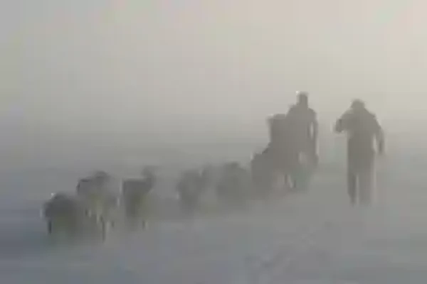
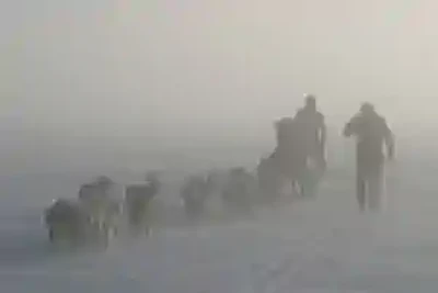
Flying in Flat Light, Brown Out Conditions, and White Out Conditions
-
Flat Light:
- Flat light is an optical illusion, also known as "sector or partial white out".
- It is not as severe as "white out" but the condition causes pilots to lose their depth-of-field and contrast in vision.
- Flat light conditions are usually accompanied by overcast skies inhibiting any visual clues.
- Such conditions can occur anywhere in the world, primarily in snow covered areas but can occur in dust, sand, mud flats, or on glassy water.
- Flat light can completely obscure features of the terrain, creating an inability to distinguish distances and closure rates.
- As a result of this reflected light, it can give pilots the illusion that they are ascending or descending when they may actually be flying level.
- However, with good judgment and proper training and planning, it is possible to safely operate an aircraft in flat light conditions.
- Flat light conditions can lead to a white out environment quite rapidly, and both atmospheric conditions are insidious; they sneak up on you as your visual references slowly begin to disappear.
-
Brown Out:
- A brownout (or brown-out) is an in-flight visibility restriction due to dust or sand in the air. In a brownout, the pilot cannot see nearby objects which provide the outside visual references necessary to control the aircraft near the ground. This can cause spatial disorientation and loss of situational awareness leading to an accident.
- The following factors will affect the probability and severity of brownout: rotor disk loading, rotor configuration, soil composition, wind, approach speed, and approach angle. 2. The brownout phenomenon causes accidents during helicopter landing and take-off operations in dust, fine dirt, sand, or arid desert terrain. Intense, blinding dust clouds stirred up by the helicopter rotor downwash during near-ground flight causes significant flight safety risks from aircraft and ground obstacle collisions, and dynamic rollover due to sloped and uneven terrain.
- This is a dangerous phenomenon experienced by many helicopters when making landing approaches in dusty environments, whereby sand or dust particles become swept up in the rotor outwash and obscure the pilot's vision of the terrain. This is particularly dangerous because the pilot needs those visual cues from their surroundings in order to make a safe landing.
- Blowing sand and dust can cause an illusion of a tilted horizon. A pilot not using the flight instruments for reference may instinctively try to level the aircraft with respect to the false horizon, resulting in an accident. Helicopter rotor wash also causes sand to blow around outside the cockpit windows, possibly leading the pilot to experience an illusion where the helicopter appears to be turning when it is actually in a level hover. This can also cause the pilot to make incorrect control inputs which can quickly lead to disaster when hovering near the ground. In night landings, aircraft lighting can enhance the visual illusions by illuminating the brownout cloud.
-
White Out:
- As defined in meteorological terms, white out occurs when a person becomes engulfed in a uniformly white glow.
- The glow is a result of being surrounded by blowing snow, dust, sand, mud or water.
- There are no shadows, no horizon or clouds and all depth-of-field and orientation are lost.
- A white out situation is severe in that there are no visual references.
- Flying is not recommended in any white out situation.
- White out has been the cause of several aviation accidents.
-
Self Induced White Out:
- This effect typically occurs when a helicopter takes off or lands on a snow-covered area.
- The rotor down wash picks up particles and re-circulates them through the rotor down wash.
- The effect can vary in intensity depending upon the amount of light on the surface.
- This can happen on the sunniest, brightest day with good contrast everywhere.
- However, when it happens, there can be a complete loss of visual clues.
- If the pilot has not prepared for this immediate loss of visibility, the results can be disastrous.
- Good planning does not prevent one from encountering flat light or white out conditions.
Loss of Visual References
- Never takeoff in a white out situation.
- Realize that in flat light conditions it may be possible to depart but not to return to that site.
- During takeoff, make sure you have a reference point.
- Do not lose sight of it until you have a departure reference point in view.
- Be prepared to return to the takeoff reference if the departure reference does not come into view.
- Flat light is common to snow skiers:
- One way to compensate for the lack of visual contrast and depth-of-field loss is by wearing amber tinted lenses (also known as blue blockers).
- Special note of caution: Eyewear is not ideal for every pilot.
- Take into consideration personal factors - age, light sensitivity, and ambient lighting conditions.
- Realize that in flat light conditions it may be possible to depart but not to return to that site.
- So what should a pilot do when all visual references are lost?
- Trust the cockpit instruments.
- Execute a 180 degree turnaround and start looking for outside references.
- Above all - fly the aircraft.
Landing in Low Light Conditions
- When landing in a low light condition - use extreme caution
- Look for intermediate reference points, in addition to checkpoints along each leg of the route for course confirmation and timing
- The lower the ambient light becomes, the more reference points a pilot should use
-
Airport Landings:
- Look for features around the airport or approach path that can be used in determining depth perception.
- Buildings, towers, vehicles or other aircraft serve well for this measurement.
- Use something that will provide you with a sense of height above the ground, in addition to orienting you to the runway.
- Be cautious of snowdrifts and snow banks - anything that can distinguish the edge of the runway.
- Look for subtle changes in snow texture or shading to identify ridges or changes in snow depth.
-
Off-Airport Landings:
- In the event of an off-airport landing, pilots have used a number of different visual cues to gain reference.
- Use whatever you must to create the contrast you need.
- Natural references seem to work best (trees, rocks, snow ribs, etc.)
- Over flight.
- Use of markers.
- Weighted flags.
- Smoke bombs.
- Any colored rags.
- Dye markers.
- Kool-aid.
- Trees or tree branches.
- It is difficult to determine the depth of snow in areas that are level. Dropping items from the aircraft to use as reference points should be used as a visual aid only and not as a primary landing reference. Unless your marker is biodegradable, be sure to retrieve it after landing. Never put yourself in a position where no visual references exist.
- Abort landing if blowing snow obscures your reference. Make your decisions early. Don't assume you can pick up a lost reference point when you get closer.
- Exercise extreme caution when flying from sunlight into shade. Physical awareness may tell you that you are flying straight but you may actually be in a spiral dive with centrifugal force pressing against you. Having no visual references enhances this illusion. Just because you have a good visual reference does not mean that it's safe to continue. There may be snow-covered terrain not visible in the direction that you are traveling. Getting caught in a no visual reference situation can be fatal.
-
Flying Around a Lake:
- When flying along lakeshores, use them as a reference point. Even if you can see the other side, realize that your depth perception may be poor. It is easy to fly into the surface. If you must cross the lake, check the altimeter frequently and maintain a safe altitude while you still have a good reference. Don't descend below that altitude.
- The same rules apply to seemingly flat areas of snow. If you don't have good references, avoid going there.
-
Other Traffic:
- Be on the look out for other traffic in the area. Other aircraft may be using your same reference point. Chances are greater of colliding with someone traveling in the same direction as you, than someone flying in the opposite direction.
-
Ceilings:
- Low ceilings have caught many pilots off guard. Clouds do not always form parallel to the surface, or at the same altitude. Pilots may try to compensate for this by flying with a slight bank and thus creating a descending turn.
-
Glaciers:
- Be conscious of your altitude when flying over glaciers. The glaciers may be rising faster than you are climbing.
- In all cases, mind possible landing illusions and atmospheric illusions.
Obstructions To Visibility Knowledge Check


Obstructions to Visibility Lessons & Case Studies
- National Transportation Safety Board (NTSB) Identification: CHI08FA054:
- The NTSB determines the probable cause(s) of this accident to be: The decision by the pilot to fly into known adverse weather, and the pilot's failure to maintain control of the airplane due to spatial disorientation. Contributing factors include the clouds and the night conditions.
- National Transportation Safety Board (NTSB) Identification: ERA22LA180:
- The NTSB determines the probable cause(s) of this accident to be: The non-instrument-rated pilot's decision to fly a visual flight rules only helicopter in instrument meteorological conditions, which resulted in a collision with trees and terrain.
- National Transportation Safety Board (NTSB) Identification: ERA09FA145:
- The NTSB determines the probable cause(s) of this accident to be: (1) The pilot's failure to perform adequate preflight planning and to use available in flight resources in a timely manner and (2) his decision to continue visual-flight-rules flight in instrument meteorological conditions despite his lack of an instrument rating and proficiency in instrument flying, which resulted in spatial disorientation and impact with terrain.
Obstructions To Visibility Conclusion
- Fog can reduce surface visibilities low enough to prevent safe takeoffs and landings
- Learning of fog or potential fog can be found on forecasts such as the Terminal Aerodrome Forecast (TAF) and Area Forecast (FA). []
- Remember that if a descent must be made through fog, smoke, or haze in order to land, the horizontal visibility is considerably less when looking through the restriction than it is when looking straight down through it from above
- Real time conditions can be found on the Aviation Routine Weather Report (METAR).
- Although fog is normally associated with weather systems, it is also be a function of temperature, potentially catching pilots off-guard when it appears right before sunrise and/or right after sunset
- Mist is not fog - as mist is defined as visbility 5/8 to 6 SM
- Improve your weather skills with FAA provided (and WINGS credited) resources by going to https://www.faasafety.gov/ and type "weather" into the search bar
- Still looking for something? Continue searching:
Obstructions To Visibility References
- FAA (FAA-H-8083-23) Aviation Weather Handbook.
- Aeronautical Information Manual (7-6-14) Flying in Flat Light and White Out Conditions.
- Aircraft Owners and Pilots Association - Weather: May Gray, June Gloom.
- Federal Aviation Administration (FAA-H-8083-28) Aviation Weather Handbook.
- Federal Aviation Administration - Instrument Flying Handbook.
- Federal Aviation Administration - Pilot/Controller Glossary.
- NOAA - Fog Types.
- Pilot Workshops - Unforecast Fog.