Convective Outlook
Convective Outlook delineates areas forecast to have or have the potential for thunderstorm (convective) activity.
Introduction to Convective Outlook
- A Convective Outlook (AC) delineates areas forecast to have thunderstorms (convective activity)
- Found at https://www.spc.noaa.gov/products/outlook/.
Convective Outlook Key Highlights
- Convective outlooks provide forecast information regarding expected thunderstorm development and severe convective weather potential.
- The Storm Prediction Center (SPC) issues convective outlooks to identify areas with potential thunderstorms, hail, damaging winds, or tornadoes.
- Pilots use convective outlooks during preflight planning to evaluate large-scale thunderstorm risk and route safety considerations.
- Outlooks categorize severe weather risk using designations such as marginal, slight, enhanced, moderate, and high risk.
- Convective weather can produce turbulence, lightning, hail, icing, wind shear, heavy precipitation, and rapidly changing flight conditions.
- Convective outlooks help pilots identify regions where thunderstorms may affect airport operations, routing, and fuel planning.
- Forecast areas may evolve significantly as atmospheric conditions change throughout the forecast period.
- Pilots should compare convective outlooks with radar imagery, SIGMETs, METARs, TAFs, and pilot reports for complete weather analysis.
- Thunderstorms should be avoided by substantial distances due to associated turbulence, hail, and severe weather hazards.
- Understanding convective outlooks improves weather hazard recognition, strategic planning, and overall flight safety.
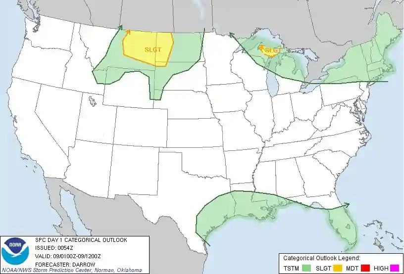
Convective Outlook Information
- The left-hand panel is the Day 1 Convective Outlook
- The right-hand panel is the Day 2 Convective Outlook
- These guidance products are produced at the Storm Prediction Center (SPC) in Norman, OK.
-
Convective Outlook
Issuance & Validity
- Issued as required
- Day 1 issued 5 times, valid first 24 hours
- Day 2 issued 2 times, valid next 24 hours
- Additional validity explained later
- Data is forecasted
Day 1 Convective Outlook
- Outlines areas where thunderstorms are forecast during the Day 1 period
- First issuance is 0600Z and is the initial Day 1 outlook valid 1200Z that day until 1200Z the following day
- The other issuances are 1300Z, 1630Z, 2000Z, and 0100Z, all valid until 1200Z the next day
- Outlooks issue qualifiers for the level of risk (SLGT, MDT, HIGH - see below), as well as areas of general thunderstorms
Day 2 Convective Outlook
- Outlines areas where thunderstorms are forecast during the Day 1 period
- Initially issued at 0830Z during standard time and 0730Z during daylight time
- It is updated at 1730Z
- Time frame covered is from 1200Z the following day to 1200Z the next day
- Day 2 outlook also issues risk qualifiers
Levels of Risk (risk qualifiers)
NOTATION
EXPLANATION
SEE TEXT
Used for those situations where a SLGT risk was considered but at the time of the forecast, was not warranted
SLGT (slight risk)
A high probability of 5 to 29 reports of 1 inch or larger hail, and/or 3-5 tornadoes, and/or 5 to 29 wind events, or a low/moderate probability of moderate to high risk being issued later if some conditions come together
MDT (moderate risk)
A high probability of at least 30 reports of hail 1 inch or larger; or 6-19 tornadoes; or numerous wind events (30)
HIGH (high risk)
A high probability of at least 20 tornadoes with at least two of them rated F3 (or higher), or an extreme derecho causing widespread (50 or more) wind events with numerous higher-end wind (80 mph or higher) and structural damage reports
Convective Outlook Knowledge Check


Convective Outlook Conclusion
- For more information, a paper copy of Federal Aviation Administration (FAA-H-8083-28) Aviation Weather Handbook [Amazon] is available for purchase
- A digital copy of Federal Aviation Administration (FAA-H-8083-28) Aviation Weather Handbook is available from the FAA's website
- Improve your weather skills with FAA provided (and WINGS credited) resources by going to https://www.faasafety.gov/ and type "weather" into the search bar
- Still looking for something? Continue searching: