Terminal Broadcast Services & Systems
Terminal Broadcast Services and systems serve as a way to decongestion frequencies for critical information.
Introduction to Terminal Broadcast Services & Systems
- There are numerous ways that pilots receive important broadcasts from ATC
- These broadcasts ultimately serve as not only great information, but a way to decongestion frequencies for critical information
Terminal Broadcast Services & Systems Key Highlights
- Terminal broadcast services and systems provide pilots with automated weather, traffic, and airport information within terminal environments.
- Automatic Terminal Information Service (ATIS) broadcasts continuous airport weather, runway, and operational information to reduce controller workload.
- Digital ATIS (D-ATIS) provides terminal information through text-based data link communication systems.
- Automatic Weather Observing Systems (AWOS) and Automated Surface Observing Systems (ASOS) deliver real-time airport weather observations.
- Terminal Radar Service Area (TRSA) radar services enhance traffic sequencing and situational awareness in designated terminal areas.
- Airport surveillance radar systems help air traffic control monitor aircraft movement and maintain separation services.
- Broadcast weather and traffic information improve pilot situational awareness during arrivals, departures, and ground operations.
- Pilots should review current broadcast information before contacting air traffic control to improve communication efficiency.
- Terminal broadcast services supplement but do not replace pilot responsibility for aircraft separation and operational awareness.
- Understanding terminal broadcast systems improves communication accuracy, traffic awareness, and overall airport operational safety.
Receiving Automated Broadcast Services
- The most common method to receive automated broadcast services is through the aircraft's radios
- Frequencies, posted in the chart supplement as well as airport diagrams and approach plates provide the frequency to receive the broadcast
- Additionally, phone numbers found in the chart supplement or the local Fixed-Base Operator (FBO) may be used before engine start-up
Automatic Terminal Information Service (ATIS)
- ATIS is the continuous broadcast of recorded non-control information in selected high activity terminal areas in order to improve controller effectiveness and to relieve frequency congestion by automating the repetitive transmission of essential but routine information
- The information is continuously broadcast over a discrete VHF radio frequency or the voice portion of a local NAVAID as a product of Air Traffic Control
- Some airports broadcast two streams, an arrival and departure ATIS:
- Arrival ATIS transmissions on a discrete VHF radio frequency are engineered according to the individual facility requirements, which would normally be a protected service volume of 20 NM to 60 NM from the ATIS site and a maximum altitude of 25,000' AGL.
- In the case of a departure ATIS, the protected service volume cannot exceed 5 NM and 100' AGL.
- At most locations, ATIS signals may be received on the surface of the airport, but local conditions may limit the maximum ATIS reception distance and/or altitude
- Pilots are urged to cooperate in the ATIS program as it relieves frequency congestion on approach control, ground control, and local control frequencies.
- The Chart Supplement U.S. indicates airports for which ATIS is provided.
-
ATIS Elements:
- Airport/facility name.
- Phonetic letter code
- Time of the latest weather sequence (UTC).
- Weather information consisting of:
- Wind direction and velocity
- Visibility.
- Obstructions to vision.
- Present weather consisting of: sky condition, temperature, dew point, altimeter, a density altitude advisory when appropriate, and other pertinent remarks included in the official weather observation.
- Instrument runway in use.
- The ceiling/sky condition, visibility, and obstructions to vision may be omitted from the ATIS broadcast if the ceiling is above 5,000' and the visibility is more than 5 miles
- The departure runway will only be given if different from the landing runway except at locations having a separate ATIS for departure
- The broadcast may include the appropriate frequency and instructions for VFR arrivals to make initial contact with approach control
- Pilots of aircraft arriving or departing the terminal area can receive the continuous ATIS broadcast at times when cockpit duties are least pressing and listen to as many repeats as desired
- ATIS broadcast must be updated upon the receipt of any official hourly and special weather
- A new recording will also be made when there is a change in other pertinent data such as runway change, instrument approach in use, etc.
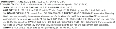
- Example: "Dulles International information Sierra. 1300 zulu weather. Measured ceiling three thousand overcast. Visibility three, smoke. Temperature six eight. Wind three five zero at eight. Altimeter two niner niner two. ILS runway one right approach in use. Landing runway one right and left. Departure runway three zero. Armel VORTAC out of service. Advise you have Sierra"
- Pilots should listen to ATIS broadcasts whenever ATIS is in operation
- Pilots should notify controllers on initial contact that they have received the ATIS broadcast by repeating the alphabetical code word appended to the broadcast.
- Example: "[Agency], [Callsign], [Location], [Information], [Intentions]"
- Example: "Danbury Tower, Cessna One Seven Two Seven Victor, 10 miles to the west, Information Sierra, inbound for landing"
- When a pilot acknowledges receipt of the ATIS broadcast, controllers may omit those items contained in the broadcast if they are current
- Rapidly changing conditions will be issued by ATC and the ATIS will contain words as follows:
- Example: "Latest ceiling/visibility/altimeter/wind/(other conditions) will be issued by approach control/tower"
- NOTE-The absence of a sky condition or ceiling and/or visibility on ATIS indicates a sky condition or ceiling of 5,000' or above and visibility of 5 miles or more.
- A remark may be made on the broadcast, "the weather is better than 5000 and 5," or the existing weather may be broadcast.
- Controllers will issue pertinent information to pilots who do not acknowledge receipt of a broadcast or who acknowledge receipt of a broadcast which is not current
- To serve frequency limited aircraft, FSSs are equipped to transmit on the omnirange frequency at most en route VORs used as ATIS voice outlets. Such communication interrupts the ATIS broadcast. Pilots of aircraft equipped to receive on other FSS frequencies are encouraged to do so in order that these override transmissions may be kept to an absolute minimum
- While it is a good operating practice for pilots to make use of the ATIS broadcast where it is available, some pilots use the phrase "have numbers" in communications with the control tower. Use of this phrase means that the pilot has received wind, runway, and altimeter information ONLY and the tower does not have to repeat this information. It does not indicate receipt of the ATIS broadcast and should never be used for this purpose
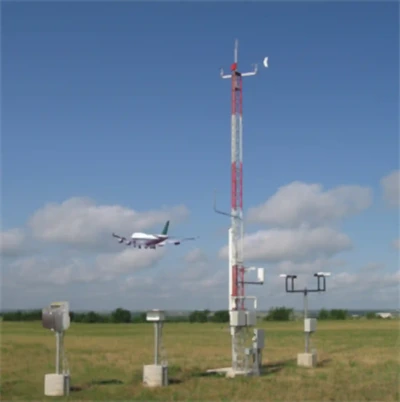
Automated Surface Observing System (ASOS)/Automated Weather Observing System (AWOS)
- Many airports are equipped with either ASOS or AWOS. []
- At most airports with an operating control tower or human observer, the weather will be available via Aviation Routine Weather Report (METAR), special observation format on the Automatic Terminal Information Service (ATIS), or directly transmitted from the controller/observer
- At uncontrolled airports that are equipped with ASOS/AWOS with ground-to-air broadcast capability, the one-minute updated airport weather should be available to you within approximately 25 NM of the airport below 10,000 feet.
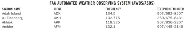
- The weather broadcast frequency will be posted on sectional charts and/or Chart Supplement U.S..
- Some part-time towered airports may also broadcast the automated weather on their ATIS frequency during the hours the tower is closed.
- Controllers issue SVFR or IFR clearances based on pilot request, known traffic and reported weather, i.e., METAR/Nonroutine (Special) Aviation Weather Report (SPECI) observations, when they are available.
- Pilots have access to more current weather at uncontrolled ASOS/AWOS airports than do the controllers who may be located several miles away.
- Controllers will rely on the pilot to determine the current airport weather from the ASOS/AWOS.
- All aircraft arriving or departing an ASOS/AWOS equipped uncontrolled airport should monitor the airport weather frequency to ascertain the status of the airspace.
- Pilots in Class E airspace must be alert for changing weather conditions which may effect the status of the airspace from IFR/VFR.
- If ATC service is required for IFR/SVFR approach/departure or requested for VFR service, the pilot should advise the controller that he/she has received the one-minute weather and state his/her intentions.
- Pilot: "I have the [Airport] one-minute weather, request an ILS Runway 14 approach.
Automated Surface Observing System (ASOS)/Automated Weather Observing System (AWOS)
- The ASOS/AWOS is the primary surface weather observing system of the U.S.
- The program to install and operate these systems throughout the U.S. is a joint effort of the NWS, the FAA and the Department of Defense
- ASOS/AWOS is designed to support aviation operations and weather forecast activities
- The ASOS/AWOS will provide continuous minute-by-minute observations and perform the basic observing functions necessary to generate an aviation routine weather report (METAR) and other aviation weather information
- The information may be transmitted over a discrete VHF radio frequency or the voice portion of a local NAVAID
- ASOS/AWOS transmissions on a discrete VHF radio frequency are engineered to be receivable to a maximum of 25 NM from the ASOS/AWOS site and a maximum altitude of 10,000' AGL
- At many locations, ASOS/AWOS signals may be received on the surface of the airport, but local conditions may limit the maximum reception distance and/or altitude
- While the automated system and the human may differ in their methods of data collection and interpretation, both produce an observation quite similar in form and content
- For the "objective" elements such as pressure, ambient temperature, dew point temperature, wind, and precipitation accumulation, both the automated system and the observer use a fixed location and time-averaging technique
- The quantitative differences between the observer and the automated observation of these elements are negligible
- For the "subjective" elements, however, observers use a fixed time, spatial averaging technique to describe the visual elements (sky condition, visibility and present weather), while the automated systems use a fixed location, time averaging technique
- Although this is a fundamental change, the manual and automated techniques yield remarkably similar results within the limits of their respective capabilities
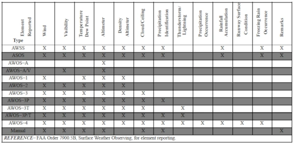
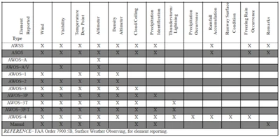
System Description:
- The ASOS/AWOS at each airport location consists of these main components:
- Individual weather sensors.
- Data collection and processing units.
- Peripherals and displays.
- The ASOS/AWOS sensors perform the basic function of data acquisition. They continuously sample and measure the ambient environment, derive raw sensor data and make them available to the collection and processing units.
- The ASOS/AWOS at each airport location consists of these main components:
- Every ASOS/AWOS will contain the following basic set of sensors:
- Cloud height indicator (one or possibly three).
- Visibility sensor (one or possibly three).
- Precipitation identification sensor.
- Freezing rain sensor (at select sites).
- Pressure sensors (two sensors at small airports; three sensors at large airports).
- Ambient temperature/Dew point temperature sensor.
- Anemometer (wind direction and speed sensor).
- Rainfall accumulation sensor.
- Automated Lightning Detection and Reporting System (ALDARS) (excluding Alaska and Pacific Island sites).
- The ASOS/AWOS data outlets include:
- Those necessary for on-site airport users.
- National communications networks.
- Computer-generated voice (available through FAA radio broadcast to pilots, and dial-in telephone line).
- Wind direction is reported relative to magnetic north in ATIS as well as ASOS and AWOS radio (voice) broadcasts
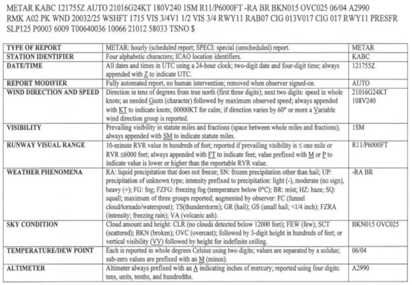
- An ASOS/AWOS report without human intervention will contain only that weather data capable of being reported automatically. The modifier for this METAR report is "AUTO." When an observer augments or backs-up an ASOS/AWOS site, the "AUTO" modifier disappears
- There are two types of automated stations, AO1 for automated weather reporting stations without a precipitation discriminator, and AO2 for automated stations with a precipitation discriminator. As appropriate, "AO1" and "AO2" must appear in remarks. (A precipitation discriminator can determine the difference between liquid and frozen/freezing precipitation) [/]

Automated Weather Observing System (AWOS)
- Automated Weather Observing Systems consist of various sensors, a processor, a computer-generated voice subsystem, and a transmitter to broadcast local, minute-by-minute weather data directly to the pilot. [/]
- AWOS observations derived from an automated system will include the prefix "AUTO"
- AWOS observations derived from an observer (rare) will include the prefix "OBSERVER WEATHER". []
- Observers provide weather and obstruction to vision information in the remarks of the report when the reported visibility is less than 7 miles.
- These sites, along with the hours of augmentation, are to be published in the Chart Supplement U.S.
- The AWOS report density altitude when it exceeds the field elevation by more than 1,000'
- The reported visibility is derived from a sensor near the touchdown of the primary instrument runway
- The visibility sensor output is converted to a visibility value using a 10-minute harmonic average
- The reported sky condition/ceiling is derived from the ceilometer located next to the visibility sensor
- The AWOS algorithm integrates the last 30 minutes of ceilometer data to derive cloud layers and heights
- This output may also differ from the observer sky condition in that the AWOS is totally dependent upon the cloud advection over the sensor site
- These real-time systems are operationally classified into nine basic levels. []
- The information is transmitted over a discrete VHF radio frequency or the voice portion of a local NAVAID. AWOS transmissions on a discrete VHF radio frequency are engineered to be receivable to a maximum of 25 NM from the AWOS site and a maximum altitude of 10,000 feet AGL. At many locations, AWOS signals may be received on the surface of the airport, but local conditions may limit the maximum AWOS reception distance and/or altitude. The system transmits a 20 to 30 second weather message updated each minute. Pilots should monitor the designated frequency for the automated weather broadcast. A description of the broadcast is contained in subparagraph c. There is no two-way communication capability. Most AWOS sites also have a dial-up capability so that the minute-by-minute weather messages can be accessed via telephone
- AWOS information (system level, frequency, phone number, etc.) concerning specific locations is published, as the systems become operational, in the Chart Supplement U.S., and where applicable, on published Instrument Approach Procedures. Selected individual systems may be incorporated into nationwide data collection and dissemination networks in the future
- Computer-generated voice is used in AWOS to automate the broadcast of the minute-by-minute weather observations. In addition, some systems are configured to permit the addition of an operator-generated voice message; e.g., weather remarks following the automated parameters. The phraseology used generally follows that used for other weather broadcasts. Following are explanations and examples of the exceptions.
Location and Time:
The location/name and the phrase "AUTOMATED WEATHER OBSERVATION," followed by the time are announced.- If the airport's specific location is included in the airport's name, the airport's name is announced.
- Example: "Bremerton National Airport automated weather observation, one four five six zulu"
- Example: "Ravenswood Jackson County Airport automated weather observation, one four five six zulu"
- If the airport's specific location is not included in the airport's name, the location is announced followed by the airport's name.
- Example: "Sault Ste. Marie, Chippewa County International Airport automated weather observation"
- Example: "Sandusky, Cowley Field automated weather observation"
- The word "TEST" is added following "OBSERVATION" when the system is not in commissioned status.
- "Bremerton National Airport automated weather observation test, one four five six zulu"
- The phrase "TEMPORARILY INOPERATIVE" is added when the system is inoperative.
- "Bremerton National Airport automated weather observing system temporarily inoperative"
- If the airport's specific location is included in the airport's name, the airport's name is announced.
Visibility:
- The lowest reportable visibility value in AWOS is "less than 1/4." It is announced as "VISIBILITY LESS THAN ONE QUARTER".
- A sensor for determining visibility is not included in some AWOS. In these systems, visibility is not announced. "VISIBILITY MISSING" is announced only if the system is configured with a visibility sensor and visibility information is not available.
Weather:
- In the future, some AWOSs are to be configured to determine the occurrence of precipitation. However, the type and intensity may not always be determined. In these systems, the word "PRECIPITATION" will be announced if precipitation is occurring, but the type and intensity are not determined.
Ceiling and Sky Cover:
- Ceiling is announced as either "CEILING" or "INDEFINITE CEILING." With the exception of indefinite ceilings, all automated ceiling heights are measured.
- "Bremerton National Airport automated weather observation, one four five six zulu. Ceiling two thousand overcast"
- "Bremerton National Airport automated weather observation, one four five six zulu. Indefinite ceiling two hundred, sky obscured"
- The word "Clear" is not used in AWOS due to limitations in the height ranges of the sensors. No clouds detected is announced as "NO CLOUDS BELOW XXX" or, in newer systems as "CLEAR BELOW XXX" (where XXX is the range limit of the sensor).
- "No clouds below one two thousand"
- "Clear below one two thousand"
- A sensor for determining ceiling and sky cover is not included in some AWOS. In these systems, ceiling and sky cover are not announced. "SKY CONDITION MISSING" is announced only if the system is configured with a ceilometer and the ceiling and sky cover information is not available.
- Ceiling is announced as either "CEILING" or "INDEFINITE CEILING." With the exception of indefinite ceilings, all automated ceiling heights are measured.
Remarks:
If remarks are included in the observation, the word "REMARKS" is announced following the altimeter setting.- Automated "Remarks".
- Density Altitude.
- Variable Visibility.
- Variable Wind Direction.
- Manual Input Remarks. Manual input remarks are prefaced with the phrase "OBSERVER WEATHER." As a general rule the manual remarks are limited to:
- Type and intensity of precipitation.
- Thunderstorms and direction; and.
- Obstructions to vision when the visibility is 3 miles or less.
- "Remarks ... density altitude, two thousand five hundred ... visibility variable between one and two ... wind direction variable between two four zero and three one zero ...observed weather ... thunderstorm moderate rain showers and fog ... thunderstorm overhead"
- If an automated parameter is "missing" and no manual input for that parameter is available, the parameter is announced as "MISSING." For example, a report with the dew point "missing" and no manual input available, would be announced as follows:
- "Ceiling one thousand overcast ... visibility three ... precipitation ... temperature three zero, dew point missing ... wind calm ... altimeter three zero zero one"
- "REMARKS" are announced in the following order of priority:
- Automated "REMARKS".
- Density Altitude.
- Variable Visibility.
- Variable Wind Direction.
- Manual Input "REMARKS".
- Sky Condition.
- Visibility.
- Weather and Obstructions to Vision.
- Temperature.
- Dew Point.
- Wind; and
- Altimeter Setting.
- "Remarks ... density altitude, two thousand five hundred ... visibility variable between one and two ... wind direction variable between two four zero and three one zero ... observer ceiling estimated two thousand broken ... observer temperature two, dew point minus five"
- Automated "REMARKS".
- Automated "Remarks".

Manual Observations
- With only a few exceptions, these reports are from airport locations staffed by FAA who manually observe, perform calculations, and enter these observations into the (WMSCR) communication system
- The format and coding of these observations are the same as those contained in Aviation Routine Weather Reports (METARs) and Aerodrome Forecasts (TAF)
Air Traffic Control Service Standards
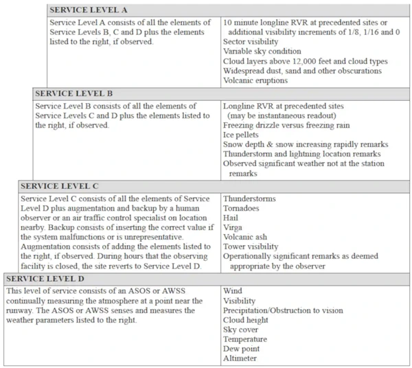
- The term "Service Standards" refers to the level of detail in weather observation. The service standards consist of four different levels of service (A, B, C, and D) as described below. []
-
Service Level D:
- Level D defines the minimum acceptable level of service.
- It is a completely automated service in which the ASOS/AWOS observation will constitute the entire observation, i.e., no additional weather information is added by a human observer.
- Information recorded include: wind, visibility, precipitation/obstruction to vision, cloud height, sky cover, temperature, dew point, and altimeter
-
Service Level C:
- Level C is a service in which the human observer, usually an air traffic controller, augments or adds information to the automated observation.
- Service Level C also includes backup of ASOS/AWOS elements in the event of an ASOS/AWOS malfunction or an unrepresentative ASOS/AWOS report.
- In backup, the human observer inserts the correct or missing value for the automated ASOS/AWOS elements.
- This service is provided by air traffic controllers under the Limited Aviation Weather Reporting Station (LAWRS) process, FSS and NWS observers, and, at selected sites, Non-Federal Observation Program observers.
- Two categories of airports require detail beyond Service Level C in order to enhance air traffic control efficiency and increase system capacity.
- Services at these airports are typically provided by contract weather observers, NWS observers, and, at some locations, FSS observers.
- Additional information recorded include: thunderstorms, tornadoes, hail, virga, volcanic ash, tower visibility, and operational significant remarks as deemed appropriate by the observer
-
Service Level B:
- Level B is a service in which weather observations consist of all elements provided under Service Level C, plus augmentation of additional data beyond the capability of the ASOS/AWOS.
- This category of airports includes smaller hubs or special airports in other ways that have worse than average bad weather operations for thunderstorms and/or freezing/frozen precipitation, and/or that are remote airports.
- Additional information recorded include: Longline RVR at precedented sites (may be instantaneous readout), Freezing drizzle versus freezing rain, Ice pellets, Snow depth & snow increasing rapidly remarks, Thunderstorm and lightning location remarks, Observed significant weather not at the station remarks
-
Service Level A:
- The highest and most demanding category, includes all the data reported in Service Standard B, plus additional requirements as specified.
- Service Level A covers major aviation hubs and/or high volume traffic airports with average or worse weather.
- Additional information recorded include: 10 minute Longline RVR at precedented sites or additional visibility increments of 1/8, 1/16 and 0 Sector visibility, Variable sky condition, Cloud layers above 12,000 feet and cloud types, Widespread dust, sand and other obscurations, Volcanic eruptions
Automatic Flight Information Service (AFIS) - Alaska FSSs Only
- AFIS is the continuous broadcast of recorded non-control information at airports in Alaska where an FSS provides local airport advisory service. Its purpose is to improve FSS specialist efficiency by reducing frequency congestion on the local airport advisory frequency.
- The AFIS broadcast will automate the repetitive transmission of essential but routine information (for example, weather, favored runway, braking action, airport NOTAMs, etc.). The information is continuously broadcast over a discrete VHF radio frequency (usually the ASOS frequency).
- Use of AFIS is not mandatory, but pilots who choose to utilize two-way radio communications with the FSS are urged to listen to AFIS, as it relieves frequency congestion on the local airport advisory frequency. AFIS broadcasts are updated upon receipt of any official hourly and special weather, and changes in other pertinent data.
- When a pilot acknowledges receipt of the AFIS broadcast, FSS specialists may omit those items contained in the broadcast if they are current. When rapidly changing conditions exist, the latest ceiling, visibility, altimeter, wind or other conditions may be omitted from the AFIS and will be issued by the FSS specialist on the appropriate radio frequency.
- "Kotzebue information ALPHA. One six five five zulu. Wind, two one zero at five; visibility two, fog; ceiling one hundred overcast; temperature minus one two, dew point minus one four; altimeter three one zero five. Altimeter in excess of three one zero zero, high pressure altimeter setting procedures are in effect. Favored runway two six. Weather in Kotzebue surface area is below V-F-R minima - an ATC clearance is required. Contact Kotzebue Radio on 123.6 for traffic advisories and advise intentions. Notice to Airmen, Hotham NDB out of service. Transcribed Weather Broadcast out of service. Advise on initial contact you have ALPHA"
- NOTE: The absence of a sky condition or ceiling and/or visibility on Alaska FSS AFIS indicates a sky condition or ceiling of 5,000 feet or above and visibility of 5 miles or more. A remark may be made on the broadcast, "the weather is better than 5000 and 5".
- Pilots should listen to Alaska FSSs AFIS broadcasts whenever Alaska FSSs AFIS is in operation.
- NOTE: Some Alaska FSSs are open part time and/or seasonally.
- Pilots should notify controllers on initial contact that they have received the Alaska FSSs AFIS broadcast by repeating the phonetic alphabetic letter appended to the broadcast.
- EXAMPLE: "Information Alpha received"
- While it is a good operating practice for pilots to make use of the Alaska FSS AFIS broadcast where it is available, some pilots use the phrase "have numbers" in communications with the FSS. Use of this phrase means that the pilot has received wind, runway, and altimeter information ONLY and the Alaska FSS does not have to repeat this information. It does not indicate receipt of the AFIS broadcast and should never be used for this purpose
Terminal Broadcast Services & Systems Knowledge Check


Terminal Broadcast Services & Systems Conclusion
- Although still early in development, you can digitally access ATIS (ATIS-D) through apps on android and apple.
- When listening to an automated broadcast in other countries, multiple languages may be used
- An English segment will always be available, however
- The FAA provides a list of surface weather observation systems which can be searched by state or airport
- Still looking for something? Continue searching:
Terminal Broadcast Services & Systems References
- Federal Aviation Administration - Pilot/Controller Glossary.
- Aeronautical Information Manual (4-1-13) Automatic Terminal Information Service (ATIS).
- Aeronautical Information Manual (4-1-14) Automatic Flight Information Service (AFIS) - Alaska FSSs Only.
- Aeronautical Information Manual (4-3-26) Operations at Uncontrolled Airports With Automated Surface Observing System (ASOS)/Automated Weather Observing System (AWOS).
- Aeronautical Information Manual (7-1-10) Weather Observing Programs.
- FAA Order (7900.5) Surface Weather Observing, for element reporting
- National Oceanic and Atmospheric Administration - Automated Surface Observing System (ASOS) User's Guide.
- Pilot Workshops - A Better Way to Get the ATIS.
- National Weather Service - Automated Surface Observing Systems.
- Watts Up With That?.