FAA Weather Services
A nationwide network of both automated and manned service stations serve to provide weather products meeting the needs of pilots.
Introduction to FAA Weather Services
- The National Weather Service maintains a network of radar sites for detecting coverage, intensity, and movement of precipitation, as well as Flight Service Stations (FSSs) to serve the weather needs of pilots.
- Local warning radar sites augment the network by operating on an as needed basis to support warning and forecast programs.
- NWS meteorologists are assigned to most Air Route Traffic Control Centers (ARTCCs) as part of the Center Weather Service Unit (CWSU).
- They provide Center Weather Advisories (CWAs) and gather weather information to support the needs of the Federal Aviation Administration (FAA) and other users to the system.
FAA Weather Services Key Highlights
- FAA weather services provide pilots with aviation weather information to support safe flight planning and operational decision-making.
- Weather products include observations, forecasts, advisories, radar imagery, satellite data, and pilot reports.
- Flight Service specialists provide weather briefings, inflight updates, and operational support for pilots.
- Automated weather systems such as AWOS and ASOS provide real-time airport weather observations and reporting.
- Graphical weather products improve situational awareness by displaying weather hazards, precipitation, cloud coverage, and turbulence information.
- PIREPs supply real-time weather observations from pilots operating within actual flight conditions.
- Weather advisories such as AIRMETs, SIGMETs, and Convective SIGMETs identify potentially hazardous atmospheric conditions.
- Pilots should evaluate weather trends, forecasts, and operational limitations before and during flight operations.
- Weather information must be interpreted carefully because conditions can change rapidly and may vary significantly along a route of flight.
- Understanding FAA weather services improves aeronautical decision-making, hazard awareness, and overall flight safety.
Observations
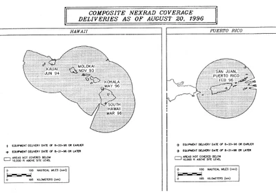
- Scheduled radar observations are taken hourly and transmitted in alpha-numeric format on weather telecommunications circuits for flight planning purposes.
- Under certain conditions, special radar reports are issued in addition to the hourly transmittals.
- Data contained in the reports are also collected by the National Center for Environmental Prediction and used to prepare national radar summary charts for dissemination on facsimile circuits.
- A clear radar display (no echoes) does not mean that there is no significant weather within the coverage of the radar site.
- Clouds and fog are not detected by the radar.
- However, when echoes are present, turbulence can be implied by the intensity of the precipitation, and icing is implied by the presence of the precipitation at temperatures at or below zero degrees Celsius.
- Used in conjunction with other weather products, radar provides invaluable information for weather avoidance and flight planning.
- All En Route Flight Advisory Service facilities and FSSs have equipment to directly access the radar displays from the individual weather radar sites.
- Specialists at these locations are trained to interpret the display for pilot briefing and inflight advisory services.
- The Center Weather Service Units located in ARTCCs also have access to weather radar displays and provide support to all air traffic facilities within their center's area.
Sources
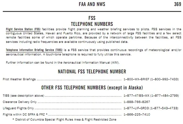
- The FAA provides the Flight Service program, which serves the weather needs of pilots through its flight service stations (FSS) (both government and contract via 1-800-WX-BRIEF) and via the Internet, through Leidos Flight Service. [
- The FAA maintains an extensive surface weather observing program. Airport observations (METAR and SPECI) in the U.S. are provided by automated observing systems. Various levels of human oversight of the METAR and SPECI reports and augmentation may be provided at select larger airports by either government or contract personnel qualified to report specified weather elements that cannot be detected by the automated observing system. []
- Other sources of weather information:
- Weather and aeronautical information are available from numerous private industry sources on an individual or contract pay basis. Prior to every flight, pilots should gather all information vital to the nature of the flight. Pilots can receive a regulatory compliant briefing without contacting Flight Service. Pilots are encouraged to use automated resources and review AC 91-92, Pilot's Guide to a Preflight Briefing, for more information.
- Pilots can access Leidos Flight Services via the Internet at https://www.1800wxbrief.com. Pilots can receive preflight weather data and file VFR and IFR flight plans.
- Discrete frequencies for individual stations are listed in the Chart Supplement U.S..
Flight Information Services (FIS)
Flight Information Services:
- Flight Information Services (FIS) is a method of disseminating meteorological (MET) and aeronautical information (AI) to displays in the cockpit in order to enhance pilot situational awareness, provide decision support tools, and improve safety.
- FIS augments (not replace) traditional pilot voice communication with Flight Service Stations (FSSs), ATC facilities, or Airline Operations Control Centers (AOCCs).
- FIS is not intended to replace traditional pilot and controller/flight service specialist/aircraft dispatcher preflight briefings or inflight voice communications.
- FIS, however, can provide textual and graphical information that can help abbreviate and improve the usefulness of such communications.
- FIS enhances pilot situational awareness and improves safety.
Data Link Service Providers (DSP):
- DSPs deploy and maintain airborne, ground-based, and, in some cases, space-based infrastructure that supports the transmission of AI/MET information over one or more physical links. A DSP may provide a free of charge or a for-fee service that permits end users to uplink and downlink AI/MET and other information.
- The following are examples of DSPs:
FAA FIS-B:
A ground-based broadcast service provided through the ADS-B Universal Access Transceiver (UAT) network. The service provides users with a 978 MHz data link capability when operating within range and line-of-sight of a transmitting ground station. FIS-B enables users of properly equipped aircraft to receive and display a suite of broadcast weather and aeronautical information products.Non-FAA FIS Systems:
Several commercial vendors (such as Garmin [Amazon]) provide customers with FIS data over both the aeronautical spectrum and on other frequencies using a variety of data link protocols. Services available from these providers vary greatly and may include tier based subscriptions. Advancements in bandwidth technology permits preflight as well as inflight access to the same MET and AI information available on the ground. Pilots and operators using non-FAA FIS for MET and AI information should be knowledgeable regarding the weather services being provided as some commercial vendors may be repackaging NWS sourced weather, while other commercial vendors may alter the weather information to produce vendor-tailored or vendor-specific weather reports and forecasts.
Three Data Link Modes:
- There are three data link modes that may be used for transmitting AI and MET information to aircraft. The intended use of the AI and/or MET information will determine the most appropriate data link service.
- Broadcast Mode: A one-way interaction in which AI and/or MET updates or changes applicable to a designated geographic area are continuously transmitted (or transmitted at repeated periodic intervals) to all aircraft capable of receiving the broadcast within the service volume defined by the system network architecture.
- Contract/Demand Mode: A two-way interaction in which AI and/or MET information is transmitted to an aircraft in response to a specific request.
- (c) Contract/Update Mode: A two-way interaction that is an extension of the Demand Mode. Initial AI and/or MET report(s) are sent to an aircraft and subsequent updates or changes to the AI and/or MET information that meet the contract criteria are automatically or manually sent to an aircraft.
- To ensure airman compliance with Federal Aviation Regulations, manufacturer's operating manuals should remind airmen to contact ATC controllers, FSS specialists, operator dispatchers, or airline operations control centers for general and mission critical aviation weather information and/or NAS status conditions (such as NOTAMs, Special Use Airspace status, and other government flight information). If FIS products are systemically modified (for example, are displayed as abbreviated plain text and/or graphical depictions), the modification process and limitations of the resultant product should be clearly described in the vendor's user guidance.
- Operational Use of FIS. Regardless of the type of FIS system being used, several factors must be considered when using FIS:
- Before using FIS for inflight operations, pilots and other flight crewmembers should become familiar with the operation of the FIS system to be used, the airborne equipment to be used, including its system architecture, airborne system components, coverage service volume and other limitations of the particular system, modes of operation and indications of various system failures. Users should also be familiar with the specific content and format of the services available from the FIS provider(s). Sources of information that may provide this specific guidance include manufacturer's manuals, training programs, and reference guides.
- FIS should not serve as the sole source of aviation weather and other operational information. ATC, FSSs, and, if applicable, AOCC VHF/HF voice remain as a redundant method of communicating aviation weather, NOTAMs, and other operational information to aircraft in flight. FIS augments these traditional ATC/FSS/AOCC services and, for some products, offers the advantage of being displayed as graphical information. By using FIS for orientation, the usefulness of information received from conventional means may be enhanced. For example, FIS may alert the pilot to specific areas of concern that will more accurately focus requests made to FSS or AOCC for inflight updates or similar queries made to ATC.
- The airspace and aeronautical environment is constantly changing. These changes occur quickly and without warning. Critical operational decisions should be based on use of the most current and appropriate data available. When differences exist between FIS and information obtained by voice communication with ATC, FSS, and/or AOCC (if applicable), pilots are cautioned to use the most recent data from the most authoritative source.
- FIS aviation weather products (for example, graphical ground-based radar precipitation depictions) are not appropriate for tactical (typical timeframe of less than 3 minutes) avoidance of severe weather such as negotiating a path through a weather hazard area. FIS supports strategic (typical timeframe of 20 minutes or more) weather decision-making such as route selection to avoid a weather hazard area in its entirety. The misuse of information beyond its applicability may place the pilot and aircraft in jeopardy. In addition, FIS should never be used in lieu of an individual preflight weather and flight planning briefing.
- DSP offer numerous MET and AI products with information that can be layered on top of each other. Pilots need to be aware that too much information can have a negative effect on their cognitive work load. Pilots need to manage the amount of information to a level that offers the most pertinent information to that specific flight without creating a cockpit distraction. Pilots may need to adjust the amount of information based on numerous factors including, but not limited to, the phase of flight, single pilot operation, autopilot availability, class of airspace, and the weather conditions encountered.
- FIS NOTAM products, including Temporary Flight Restriction (TFR) information, are advisory-use information and are intended for situational awareness purposes only. Cockpit displays of this information are not appropriate for tactical navigation - pilots should stay clear of any geographic area displayed as a TFR NOTAM. Pilots should contact FSSs and/or ATC while en route to obtain updated information and to verify the cockpit display of NOTAM information.
- FIS supports better pilot decision-making by increasing situational awareness. Better decision-making is based on using information from a variety of sources. In addition to FIS, pilots should take advantage of other weather/NAS status sources, including, briefings from Flight Service Stations, data from other air traffic control facilities, airline operation control centers, pilot reports, as well as their own observations.
- FAA's Flight Information Service-Broadcast (FIS-B).
- FIS-B is a ground-based broadcast service provided through the FAA's Automatic Dependent Surveillance–Broadcast (ADS-B) Services Universal Access Transceiver (UAT) network. The service provides users with a 978 MHz data link capability when operating within range and line-of- sight of a transmitting ground station. FIS-B enables users of properly-equipped aircraft to receive and display a suite of broadcast weather and aeronautical information products.
- Text and graphical products available through FIS-B and provided free-of-charge. []
- Detailed information concerning FIS-B meteorological products can be found in FAA (FAA-H-8083-28) Aviation Weather Handbook, and AC 00-63, Use of Cockpit Displays of Digital Weather and Aeronautical Information. Information on Special Use Airspace (SUA), Temporary Flight Restriction (TFR), and Notice to Airmen (NOTAM) products can be found in Chapters 3, 4 and 5 of the Aeronautical Information Manual.
- Users of FIS-B should familiarize themselves with the operational characteristics and limitations of the system, including: system architecture; service environment; product lifecycles; modes of operation; and indications of system failure.
- The NOTAM-D and NOTAM-FDC products broadcast via FIS-B are limited to those issued or effective within the past 30 days. Except for TFRs, NOTAMs older than 30 days are not provided. The pilot in command is responsible for reviewing all necessary information prior to flight.
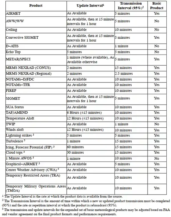
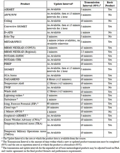
- FIS-B products are updated and transmitted at specific intervals based primarily on product issuance criteria. Update intervals are defined as the rate at which the product data is available from the source for transmission. Transmission intervals are defined as the amount of time within which a new or updated product transmission must be completed and/or the rate or repetition interval at which the product is rebroadcast. []
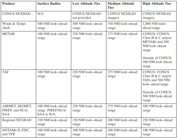
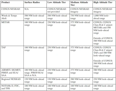
- Where applicable, FIS-B products include a look-ahead range expressed in nautical miles (NM) for three service domains: Airport Surface; Terminal Airspace; and Enroute/Gulf-of-Mexico (GOMEX) [//]
- Prior to using this capability, users should familiarize themselves with the operation of FIS-B avionics by referencing the applicable User's Guides. Guidance concerning the interpretation of information displayed should be obtained from the appropriate avionics manufacturer.
- FIS-B malfunctions not attributed to aircraft system failures or covered by active NOTAM should be reported by radio or telephone to the nearest FSS facility, or by sending an email to the ADS-B help desk at adsb@faa.gov.
- Reporters should include:
- Condition observed.
- Date and time of observation.
- Altitude and location of observation.
- Type and call sign of the aircraft.
- Type and software version of avionics system.
- There are three data link modes that may be used for transmitting AI and MET information to aircraft. The intended use of the AI and/or MET information will determine the most appropriate data link service.
Non-FAA FIS Systems:
Several commercial vendors also provide customers with FIS data over both the aeronautical spectrum and on other frequencies using a variety of data link protocols. In some cases, the vendors provide only the communications system that carries customer messages, such as the Aircraft Communications Addressing and Reporting System (ACARS) used by many air carrier and other operators.- Operators using non-FAA FIS data for inflight weather and other operational information should ensure that the products used conform to FAA/NWS standards. Specifically, aviation weather and NAS status information should meet the following criteria:
- The products should be either FAA/NWS "accepted" aviation weather reports or products, or based on FAA/NWS accepted aviation weather reports or products. If products are used which do not meet this criteria, they should be so identified. The operator must determine the applicability of such products to their particular flight operations.
- In the case of a weather product which is the result of the application of a process which alters the form, function or content of the base FAA/NWS accepted weather product(s), that process, and any limitations to the application of the resultant product, should be described in the vendor's user guidance material.
- An example would be a NEXRAD radar composite/mosaic map, which has been modified by changing the scaling resolution. The methodology of assigning reflectivity values to the resultant image components should be described in the vendor's guidance material to ensure that the user can accurately interpret the displayed data.
- Operators using non-FAA FIS data for inflight weather and other operational information should ensure that the products used conform to FAA/NWS standards. Specifically, aviation weather and NAS status information should meet the following criteria:
-
Flight Information Service-Broadcast (FIS-B):
-
FIS-B Introduction:
- FIS-B is a ground broadcast service provided through the ADS-B Services network over the 978 MHz UAT data link.
- The FAA FIS-B system provides pilots and flight crews of properly equipped aircraft with a cockpit display of certain aviation weather and aeronautical information.
- FIS-B reception is line-of-sight within the service volume of the ground infrastructure.
-
FIS-B Weather Products:
- FIS-B does not replace a preflight weather briefing from FAA Weather Services, or inflight updates from an FSS or ATC.
- FIS-B information may be used by the pilot for the safe conduct of flight and aircraft movement; however, the information should not be the only source of weather or aeronautical information.
- A pilot should be particularly alert and understand the limitations and quality assurance issues associated with individual products.
- This includes graphical representation of next generation weather radar (NEXRAD) imagery and Notices to Air Missions (NOTAM)/temporary flight restrictions (TFR).
-
Reporting FIS-B Malfunctions:
- Users of FIS-B can provide valuable assistance in the correction of malfunctions by reporting instances of undesirable system performance.
- Since FIS-B performance is monitored by maintenance personnel rather than ATC, report malfunctions to the nearest Flight Service Station (FSS) facility by radio or telephone, or by sending an email to the ADS-B help desk at adsb@faa.gov.
- Reporters should identify:
- Condition observed.
- Date and time of observation.
- Altitude and location of observation.
- Type and call sign of the aircraft.
- Type and software version of avionics system.
-

Hazardous In-Flight Weather Advisory Service (HIWAS)
- HIWAS was an automated, continuous broadcast of inflight weather advisories, provided by FSS over select VOR outlets, which include the following weather products: AWW, SIGMET, Convective SIGMET, CWA, AIRMET (text [WA] or graphical [G-AIRMET] products), and urgent PIREP
- HIWAS was discontinued in January 2020 and replaced by Flight Information Service-Broadcast (FIS-B).
FAA Weather Services Interactive Scenario
Interactive Scenario
Loading scenario details...
Decision 1
0%
Scenario Complete
FAA Weather Services Knowledge Check
Private Pilot

Core Knowledge Review
Review the foundational knowledge, key concepts, and practical considerations for FAA Weather Services.
Foundational
Immediate Feedback
Answer Explanations
Commercial Pilot

Advanced Application
Apply your knowledge of FAA Weather Services to advanced operational scenarios, risk management, and aeronautical decision-making.
Advanced
Scenario Based
Risk Management
Why Take a Quiz?
Quizzes reinforce key concepts, identify knowledge gaps, and build confidence for real-world decisions in the cockpit.
FAA Weather Services Conclusion
- Details concerning the content, format, and symbols of the various data link products provided should be obtained from the specific avionics manufacturer
- NOTAM-D and NOTAM-FDC products broadcast via FIS-B are limited to those issued or effective within the past 30 days
- Pilots can access Leidos Flight Service via Internet Access: https://www.1800wxbrief.com, or for customer service: 1-800-WXBRIEF
- Recognize that when receiving weather updates, both avionics and ground-based systems have some delay that should be considered when making weather-based decisions
- Still looking for something? Continue searching:
FAA Weather Services References
- Federal Aviation Administration (FAA-H-8083-28) Aviation Weather Handbook.
- Federal Aviation Administration - Pilot/Controller Glossary.
- Aeronautical Information Manual (7-1-2) FAA Weather Services.
- Aeronautical Information Manual (expired) En Route Flight Advisory Service (EFAS).
- Center Weather Service Unit (CWSU).