Ground-Based Augmentation System
The Ground-Based Augmentation System (GBAS) Landing System (GLS) provides precision navigation guidance for aircraft on approach to a runway.
Introduction to Ground-Based Augmentation System
- A GBAS ground installation at an airport can provide localized, differential augmentation to the Global Positioning System (GPS) signal-in-space enabling an aircraft's GLS precision approach capability. Through the GBAS service and the aircraft's GLS installation a pilot may complete an instrument approach offering three-dimensional angular, lateral, and vertical guidance for exact alignment and descent to a runway. The operational benefits of a GLS approach are similar to the benefits of an ILS or LPV approach operation.
- To remain consistent with international terminology, the FAA will use the term GBAS in place of the former term Local Area Augmentation System (LAAS).
- Test your understanding of Ground-Based Augmentation System by completing the knowledge quiz, applying your knowledge in the interactive scenario, comparing your performance against the applicable Airman Certification Standards, and concluding with the topic summary to reinforce the key concepts before moving on to the next lesson.
Ground-Based Augmentation System Key Highlights
- Ground-Based Augmentation Systems (GBAS) improve GPS navigation accuracy and integrity for precision approach and landing operations.
- GBAS uses ground reference stations at airports to monitor GPS signal errors and transmit correction data to aircraft.
- The system supports highly accurate lateral and vertical guidance during instrument approach procedures.
- GBAS technology enables GLS approaches, which provide precision-like guidance similar to Instrument Landing Systems (ILS).
- Ground-based correction signals improve navigation reliability by compensating for atmospheric and satellite-related GPS errors.
- GBAS supports flexible approach path design and can reduce the need for multiple traditional ground-based navigation installations.
- Aircraft must be equipped with compatible avionics systems to conduct GBAS or GLS approach operations.
- Pilots must verify equipment capability, database currency, and applicable operational procedures before using GBAS guidance.
- Signal interruptions, equipment malfunctions, or integrity warnings may limit GBAS availability during flight operations.
- Understanding GBAS operation improves precision navigation capability, instrument approach proficiency, and overall flight safety.
Ground-Based Augmentation System Landing System
-
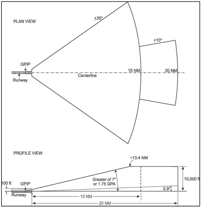
GLS Standard Approach Service Volume - An aircraft's GLS approach capability relies on the broadcast from a GBAS Ground Facility (GGF) installation. The GGF installation includes at least four ground reference stations near the airport's runway(s), a corrections processor, and a VHF Data Broadcast (VDB) uplink antenna. To use the GBAS GGF output and be eligible to conduct a GLS approach, the aircraft requires eligibility to conduct RNP approach (RNP APCH) operations and must meet the additional, specific airworthiness requirements for installation of a GBAS receiver intended to support GLS approach operations. When the aircraft achieves GLS approach eligibility, the aircraft's onboard navigation database may then contain published GLS instrument approach procedures
- During a GLS instrument approach procedure, the installation of an aircraft's GLS capability provides the pilot three-dimensional (3D) lateral and vertical navigation guidance much like an ILS instrument approach. GBAS corrections augment the GPS signal-in-space by offering position corrections, ensures the availability of enhanced integrity parameters, and then transmits the actual approach path definition over the VDB uplink antenna. A single GBAS ground station can support multiple GLS approaches to one or more runways
- Through the GBAS ground station, a GLS approach offers a unique operational service volume distinct from the traditional ILS approach service volume (see FIG 1-1-9). However, despite the unique service volume, in the final approach segment, a GLS approach provides precise 3D angular lateral and vertical guidance mimicking the precision guidance of an ILS approach [Figure 4.]
- Transitions to and segments of the published GLS instrument approach procedures may rely on use of RNAV 1 or RNP 1 prior to an IAF. Then, during the approach procedure, prior to the aircraft entering the GLS approach mode, a GLS approach procedure design uses the RNP APCH procedure design criteria to construct the procedural path (the criteria used to publish procedures titled "RNAV (GPS)" in the US). Thus, a GLS approach procedure may include paths requiring turns after the aircraft crosses the IAF, prior to the aircraft's flight guidance entering the GLS approach flight guidance mode. Likewise, the missed approach procedure for a GLS approach procedure relies exclusively on the same missed approach criteria supporting an RNP APCH
- When maneuvering the aircraft in compliance with an ATC clearance to intercept a GLS approach prior to the final approach segment (e.g. "being vectored"), the pilot should adhere to the clearance and ensure the aircraft intercepts the extended GLS final approach course within the specified service volume. Once on the GLS final approach course, the pilot should ensure the aircraft is in the GLS approach mode prior to reaching the procedure's glidepath intercept point. Once the aircraft is in the GLS flight guidance mode and captures the GLS glidepath, the pilot should fly the GLS final approach segment using the same pilot techniques they use to fly an ILS final approach or the final approach of an RNAV (GPS) approach flown to LPV minimums. See also the Instrument Procedures Handbook for more information on how to conduct a GLS instrument approach procedure
GLS Procedure
- Pilots will select the five digit GBAS channel number of the associated GLS approach within the Flight Management System (FMS) menu or manually select the five digits (system dependent). Selection of the GBAS channel number also tunes the VDB
- Following procedure selection, confirmation that the correct GLS procedure is loaded can be accomplished by cross checking the charted Reference Path Indicator (RPI) or approach ID with the cockpit displayed RPI or audio identification of the RPI with Morse Code (for some systems). Distance to the runway threshold will be displayed to the pilot once the aircraft is inside the approach service volume
- The pilot will fly the GLS approach using many of the same techniques as ILS including using a heading or lateral steering mode to intercept the GLS final approach course and then switching to the appropriate approach navigation mode once the aircraft is within the approach service volume and prior to the glide path intercept point. See also the Instrument Procedures Handbook for more information on GLS
Ground-Based Augmentation System Interactive Scenario
Interactive Scenario
Loading scenario details...
Decision 1
0%
Scenario Complete
Ground-Based Augmentation System Knowledge Check
Private Pilot

Core Knowledge Review
Review the foundational knowledge, key concepts, and practical considerations for Ground-Based Augmentation System.
Foundational
Immediate Feedback
Answer Explanations
Commercial Pilot

Advanced Application
Apply your knowledge of Ground-Based Augmentation System to advanced operational scenarios, risk management, and aeronautical decision-making.
Advanced
Scenario Based
Risk Management
Why Take a Quiz?
Quizzes reinforce key concepts, identify knowledge gaps, and build confidence for real-world decisions in the cockpit. Quiz material is representative of the information provided here and is not based on or sourced from the Federal Aviation Administration test bank.
Ground-Based Augmentation System Conclusion
- Remember, the FAA requests user reports on NAVAID outages.
- Still looking for something? Continue searching: