High-Altitude Approaches
High-altitude approaches are instrument approaches that quickly transition aircraft from the high altitude to terminal environment.
Introduction
Introduction
- High-altitude approaches allow for the quickest transition from the high altitude structure to an instrument approach to land
- Outlined similarly to a low altitude approach plate
- They are particularly useful for the military with high performance aircraft that have high fuel burns, especially at the lower altitudes
Minute to Live Rule
Minute to Live Rule
- You shall not descend at a rate faster than altitude left to go
- 5000' = 5000 fpm max
- 4000' = 4000 fpm max
- 3000' = 3000 fpm max
- 2000' = 2000 fpm max
- 1000' = 1000 fpm max
- Inside the Final Approach Fix: 1000 fpm max
Flying a High Altitude Approach
Flying a High Altitude Approach
-
Penetration From Holding:
- Choose the appropriate method to accelerate from holding airspeed to 250 KIAS (TACAN penetration speed)
- For fuel conservation:
- Plan to intercept 250 KIAS as you descend out of altitude
- At the fix, lower the nose and begin descent while accelerating to 250 KIAS
- As airspeed approaches 250 KIAS, reduce power to IDLE and extend the speed brakes if necessary
- For timing considerations (CV approaches):
- Accelerate to arrive at the IAF at 250 KIAS
- Once cleared inbound and on course, perform a level speed change from 200 KIAS to 250 KIAS
- At the IAF, simultaneously lower the nose and accelerate to 250 KIAS. At 250 KIAS, reduce power to IDLE and adjust nose attitude and trim to maintain speed, countering the resulting nose pitch-up with forward stick. Re-trim for 250 KIAS
- To begin penetration, the aircraft must be established on the initial approach course
- May be done with or without speed brakes as required for the descent
- During approaches to airfields, retract boards when the profile allows and maintain 250 KIAS
- Unlike airfield approaches, CV penetrations are closely sequenced and require all aircraft to maintain 250 KIAS and 4,000 FPM until 5000' AGL (platform)
- At platform, CV aircraft reduce rate of descent from 4,000 to 2,000 FPM by retracting speed brakes and maintaining 250 KIAS
- REMEMBER TO CALL PLATFORM AND OBEY THE MINUTE TO LIVE RULE
-
In Lieu of an En-Route Descent:
- Pilot is expected to execute the entire IAP unless visual contact is made and a visual or contract approach is request and approved, or if the pilot cancels his IFR flight plan
- It is solely the pilots prerogative to cancel his IFR clearance
- Retention of the IFR clearance does not afford priority over VFR traffic and may have to adjust his flight path as necessary to enter traffic pattern in sequence
- After receiving a revised clearance, or any approach clearance, prior to the final approach descent
- All military pilots will report the newly assigned/designated altitude when they report vacating the previously assigned altitude/flight level
-
En-Route Descent:
- Used to transition from an en-route altitude to the final portion of an instrument or visual approach in lieu of published penetrations
- Type of final approach to be flown (GCA, ILS, etc.) should be understood by both the pilot and the controller prior to commencing the descent
- Routing may be via radar vectors or the NAVAIDs depicted on the high altitude charts
- You may request, or a controller may initiate an en route descent; however, the controller must advise you of intention to provide this service and you may refuse it in favor of a published IAP
- Prior to issuance of a descent clearance below the highest initial approach fix altitude established for ANY high altitude instrument procedure for the destination airport, the controller will inform the pilot of:
- Type of final approach to expect
- RADAR vectors will be provided to the final course
- Current weather, whenever the ceiling is below either 1,000' or the highest circling minimum, or when visibility is less than 3 miles
- Pilots may request a High Altitude Instrument Approach in lieu of an en-route descent
Pilot Request: "Request en-route descent to [Airport]" -
Inside the Final Approach Fix (FAF):
- 1500 PPH should set up a good start descent
- Every 100 PPH = 300 fpm in the landing configuration
- 2000 PPH should keep the aircraft level, boards out
Single Frequency Approach (SFA)
Single Frequency Approach (SFA)
- Provided to single piloted jet aircraft on an IFR flight plan during the hours of darkness or when the aircraft is in instrument weather conditions
- The abbreviation "SFA" will be shown after the heading "COMMUNICATIONS" in the FLIP IFR En-route Supplement when procedures have been implemented at that station
- For those military fields that do not indicate "SFA," check the RADAR section of the FLIP (terminal) for that airfield
- If they have numerous UHF frequencies available, you can request SFA in the remarks section of the DD-175
- Pilots receiving this service will not be required to change frequency from beginning of penetration to touchdown, except that pilots conducting an en-route descent are required to change frequency when control is transferred from the ARTCC to the terminal facility
- Controllers may discontinue the service to all pilots who cancel IFR flight plans during daylight hours and to those pilots in level flight who cancel IFR flight plans at night
Pilot Briefing and Procedure Notes
Pilot Briefing and Procedure Notes
- Includes NAVAIDs required and the final approach course with limited airport information for quick reference
- Notes referencing the approach as a whole will be included
- Approach light systems will be labeled and depicted
- Missed approach instructions are published in text
- Types of radar coverage available (ASR/PAR)
- Frequencies for:
- ATIS
- Approach
- Any headings listed for different frequencies are based on your heading TO the airport
- Example: Heading 270 a note 360-200 would mean you do NOT use that one while a 200-360 would be the correct frequency
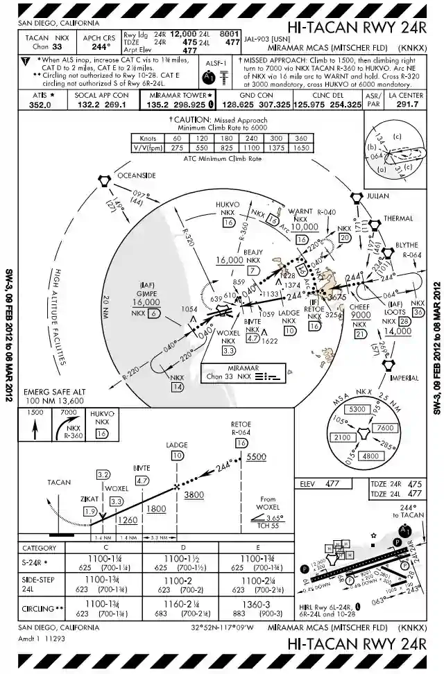
Plan View
Plan View
- 20-mile radius circle around the navigation facility features encircled by bold print line are to scale
- Feeders will be included when able but normally won't be to scale, expect a radial and DME
- Used mostly to orient one remote NAVAID to another
- The terrain within 6 NM of airfield rises to at least 2,000' above airfield elevation
- The terrain within the plan-view "to scale" area exceeds 4,000' above the airport elevation
- Four basic penetration patterns:
- Straight-in
- Offset
- Arcing
- Teardrop
Holding Patterns
Holding Patterns
- Used until you are cleared to proceed beyond the IAF onto the approach
- Thin solid line with notations indicate arrival holding
- Holding in lieu of a procedure turn is NOT depicted on high altitude approach plates
- Entry diagram found on the upper right corner of plan view to assist with entry
- Missed approach holding patterns are depicted the same as the route
Obstacles
Obstacles
- All obstacles are referenced from Mean Sea Level (MSL)
- Single: inverted V with elevation in feet
- Group: two overlapping inverted Vs with elevation in feet
- Highest: large inverted V with elevation in feet
Spot Elevation
Spot Elevation
- All elevations are referenced from Mean Sea Level (MSL)
- Indicated by a dot with elevation in feet
- Highest: bold dot with elevation in feet
- MSA: Minimum safe for a radius of 25 NM from the approach NAVAID (labeled) divided into sectors of at least 90° with different altitudes
- ESA: Emergency safe for a radius of 100 NM from the approach NAVAID (NOT labeled) providing 1,000' / 2,000' clearance in normal and mountainous areas respectively
Penetration Track
Penetration Track
- Begins at the IAF to the FAF and is depicted by a bold dotted line
- Vertical accent lines depicted altitude restriction DMEs
Procedure Track
Procedure Track
- Begins at the FAF to the MAP
- Depicted by a thick solid line
Missed Approach Route
Missed Approach Route
- Printed instructions in profile view box as with any approach
- Depicted with a dashed line
Airport Diagram
Airport Diagram
- Sketched on approach plate oriented to magnetic north giving basic airport information
- See Airport Diagram
FAF to MAP chart
FAF to MAP chart
- Used on non-precision approaches when DME unavailable and radio facility not located at field
- Gives the distance from the FAF to MAP in NM
- Gives time to traverse distance at a given ground speed in minutes and seconds
Minimums
Minimums
- Type: straight-in or circling
- Category: B/C/D/E
- Ceiling and visibility required are in parenthesis (RVR next to MDA/DH)
- Minimum Descent Altitude (MDA), Decision Altitude (DA) given in feet MSL
Conclusion
Conclusion
- To learn more about instrument procedures, be sure to check out the Instrument Procedures Handbook online or in paperback
- Pilots can visit the FAA's Instrument Flight Procedures Information Gateway to review and submit questions related to the how and why certain procedures are as they are
- Still looking for something? Continue searching:
References
References