Area Forecast
Area Forecasts are a forecast of Visual Meteorological Conditions (VMC), clouds, and general weather conditions over a region.
Introduction to Area Forecast
- An Area Forecast (FA) is a forecast of Visual Meteorological Conditions (VMC), clouds, and general weather conditions over an area the size of several states
- FAs cover ten areas throughout the United States whose validity times allow for advanced planning for regional flights
- Details provided result in a categorical outlook which allow for determining regions experiencing Instrument Flight Rules (IFR), Low IMR, Visual Flight Rules (IFR), and marginal VFR conditions
- FAs can be found on the National Oceanic and Atmospheric Administration (NOAA) website at: https://www.aviationweather.gov/gfa
Area Forecast Key Highlights
- Area forecasts provided broad aviation weather information for large geographic regions and supported route planning decisions.
- Traditional area forecasts described expected clouds, visibility, weather phenomena, and general conditions across forecast areas.
- Pilots used area forecasts to evaluate en route weather where airport-specific TAFs were unavailable or insufficient.
- Area forecasts helped identify widespread IFR conditions, mountain obscuration, precipitation, and other regional weather concerns.
- The FAA replaced many traditional area forecast products with graphical aviation weather products for improved weather visualization.
- Graphical Forecasts for Aviation (GFA) now provide many of the weather planning functions formerly served by area forecasts.
- Pilots should use current aviation weather products such as GFA, TAFs, METARs, AIRMETs, SIGMETs, and radar imagery for route planning.
- Regional forecast products require careful interpretation because local conditions may differ from broad forecast descriptions.
- Weather forecasts should be updated before and during flight when conditions may affect route, fuel, or alternate planning.
- Understanding area forecasts improves aviation weather interpretation, strategic planning, and overall flight safety.
Area Forecast Background
- Area forecasts are regional forecasts
Issuance & Validity
-
Issuance:
- Issued 3 times daily (times vary by area)
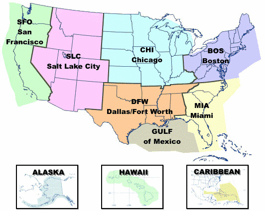
- Issued for: [Figure 1]
- Boston (BOS)
- Chicago (CHI)
- Salt Lake City (SLC)
- San Francisco (SFO)
- Dallas/Fort Worth (DFW)
- Miami (MIA)
- Gulf of Mexico (GULF)
- Hawaii
- Alaska
- Caribbean Areas
-
Validity:
- Valid for 12 hours forecast and 6 hours outlook (18 total)
- Data is forecasted
Categorical Outlooks
- Categorical outlook terms, describing general ceiling and visibility conditions for advanced planning purposes are used only in area forecasts
-
LIFR (Low IFR):
- Ceiling less than 500 feet and/or visibility less than 1 mile
-
IFR:
- Ceiling 500 to less than 1,000 feet and/or visibility 1 to less than 3 miles
-
MVFR (Marginal VFR):
- Ceiling 1,000 to 3,000 feet and/or visibility 3 to 5 miles inclusive
-
VFR:
- Ceiling greater than 3,000 feet and visibility greater than 5 miles; includes sky clear
- The cause of LIFR, IFR, or MVFR is indicated by either ceiling or visibility restrictions or both
- The contraction "CIG" and/or weather and obstruction to vision symbols are used
- If winds or gusts of 25 knots or greater are forecast for the outlook period, the word "WIND" is also included for all categories including VFR
- Examples:
- LIFR CIG: low IFR due to low ceiling
- IFR FG: IFR due to visibility restricted by fog
- MVFR CIG HZ FU: marginal VFR due to both ceiling and visibility restricted by haze and smoke
- IFR CIG RA WIND: IFR due to both low ceiling and visibility restricted by rain; wind expected to be 25 knots or greater
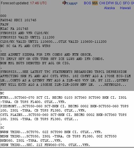
Area Forecast Reports
- Area forecasts are reported using four elements:
-
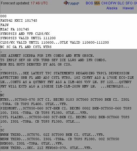
Communications and Product Header:
- 000 does not apply to the forecast
- FA indicates an Area Forecast with a World Meteorological Organization (WMO) header [Figure 2]
- FAUS41: Boston Area
- FAUS42: Miami Area
- FAUS43: Chicago Area
- FAUS44: Dallas, Ft. Worth Area
- FAUS45: Salt Lake City Area
- FAUS46: San Francisco Area
- The issuing agency will be listed:
- KKCI: Aviation Weather Center (AWC)/Meteorological Watch Office (MWO) in Kansas City
- PAWU: Alaska Aviation Weather Unit (AAWU)/MWO in Anchorage
- PHFO: Honolulu Weather Forecast Office (WFO)/MWO in Honolulu
- An Advanced Weather Interactive Processing System (AWIPS) ID will be included which corresponds with the WMO header
- The ID is now replaced with the WMO header but is left there to be clear for those who are used to an older system
- FA1: Corresponds with FAUS41
- FA2: Corresponds with FAUS42
- FA3: Corresponds with FAUS43
- FA4: Corresponds with FAUS44
- FA5: Corresponds with FAUS45
- FA6: Corresponds with FAUS46
- The ID is now replaced with the WMO header but is left there to be clear for those who are used to an older system
- The area the forecast applies to is listed again (clearly) but with a "C" appended, which indicates clouds and weather forecast
- BOSC: Boston (clouds and weather forecast)
- MIAC: Miami (clouds and weather forecast)
- CHIC: Chicago (clouds and weather forecast)
- DFWC: Dallas, Ft. Worth (clouds and weather forecast)
- SLCC: Salt Lake City (clouds and weather forecast)
- SFOC: San Francisco (clouds and weather forecast)
- Issued date: day of the month and time; valid time begins 15 minutes later
- 101745: Issued on the 10th day of the month at 1745 Zulu (Z)
- Valid time begins on the hour at 1800Z
- 101745: Issued on the 10th day of the month at 1745 Zulu (Z)
- "SYNOPSIS AND VFR CLDS/WX" is a standard line for all forecasts
- Validity times are listed last for the synopsis, clouds and weather, and outlook:
- SYNOPSIS VALID UNTIL 111200: valid until the 11th day of the month at 1200Z
- CLOUDS/WX VALID UNTIL 110600: valid until the 11th day of the month at 0600Z
- OTLK VALID 110600-111200: valid between the 11th day of the month from 0600Z to 1200Z
-
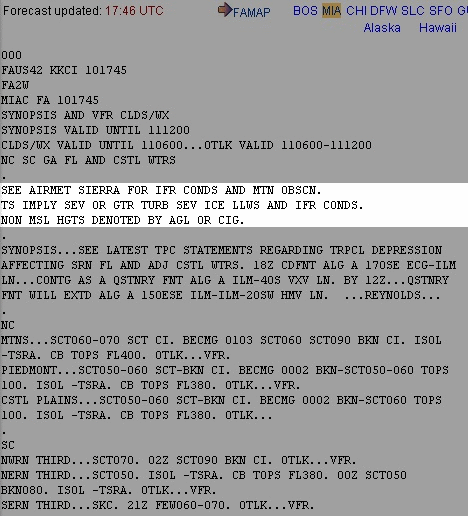
Precautionary Statements:
- Part of all area forecasts [Figure 3]
- See AIRMET Sierra and IFR conditions and mountain obscuration
- Thunderstorms imply possible severe or greater turbulence, severe icing, low-level wind shear, and instrument conditions
- Heights which are not Mean Sea Level (MSL) are noted by the letters AGL (above ground level) or CIG (ceiling)
-
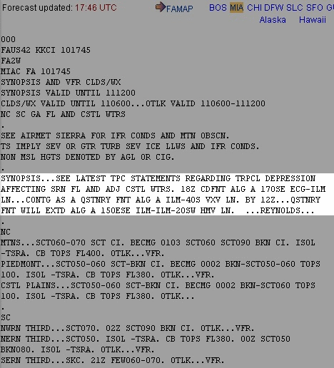
Synopsis:
- Contains many abbreviations that are found on various weather reports [Figure 4]
- Brief description of the location and movement of fronts, pressure systems, and circulation patterns
- Valid for 18 hours or until the date time group (DTG) in the same format as the issue DTG
- SYNOPSIS VALID UNTIL 251400: Synopsis valid until the 25th day at 1400Z
-
VFR Clouds and Weather:
- Section contains a 12-hour specific forecast followed by a 6-hour categorical outlook for a total of 18 hours [Figure 5]
- Usually several paragraphs in length
- The breakdown may be by several states or known geographical areas
- The specific forecast section gives a general description of clouds and weather which cover an area greater than 3,000 square miles and are significant to VFR flight operations
- Clouds and Weather are valid until date time group in the same format as the issue DTG
- CLDS/WX VALID UNTIL 250800: Clouds and weather valid until the 25th day at 0800Z
- Outlook valid from the DTG to the DTG listed
- OTLK VALID 250800-251400: Outlook valid from the 25th day from 0800 to 1400Z the same day
- The next line is the encompassing states covered by the report
- NC, SC, GA, FL AND CSTL WTRS E OF 85W: North and South Carolina, Georgia, Florida and coastal waters east of 85°W Longitude
- An amended FA will have an AMD or COR in the heading of the forecast
Area Forecast Conclusion
- Area forecasts will give you a general overview of an area of operation and are particularly useful for cross-country planning
- For more information, a paper copy of Federal Aviation Administration (FAA-H-8083-28) Aviation Weather Handbook [Amazon] is available for purchase
- A digital copy of Federal Aviation Administration (FAA-H-8083-28) Aviation Weather Handbook is available from the FAA's website
- Improve your weather skills with FAA provided (and WINGS credited) resources by going to https://www.faasafety.gov/ and type "weather" into the search bar
- Still looking for something? Continue searching:
Area Forecast References
- Federal Aviation Administration (FAA-H-8083-28) Aviation Weather Handbook
- Federal Aviation Administration - Pilot/Controller Glossary
- Aeronautical Information Manual (7-1-6) Categorial Outlooks
- Aviation Weather.gov
- Maps.AvnWx.com.
- CFI Notebook.net - Atmosphere
- FAA - JO 7110.10 "Flight Services" (9.6) Aviation Area Forecast (FA)