Radar Summary Chart
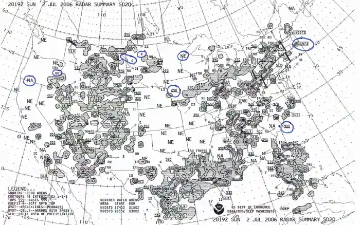
A radar summary chart is a graphical depiction display of collections of automated radar weather reports.
Introduction
- A radar summary chart is a graphical depiction display of collections of automated radar weather reports (SD/ROB)
Radar Summary Chart
- Radar summary charts provide a synopsis of weather radar returns across the country
Issuance & Validity
- Issued every hour
- Information is about 35 minutes old
- Information is all observed data
- Should be used as a supplement to other preflight weather data
Information
- A legend is printed on the chart
- It displays areas of precipitation, type, intensity, configuration, coverage, tops and cell movements of precipitation
Fronts
- Shows positions and types of fronts
- A three-digit number near a front classifies it as to type, intensity, and character enclosed in brackets ([ or ])
Intensity
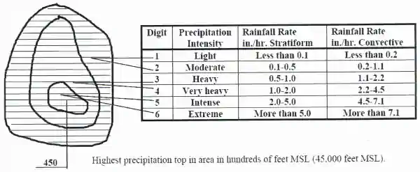
- Intensity is obtained from the amount of energy returned to the radar from the target and is indicated by chart contours
Radar Echos
-
Precipitation Echo Type:
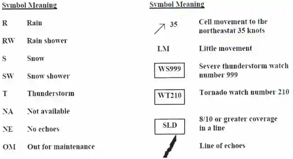
- Types of precipitation are located adjacent to the precipitation areas
-
Echo Configuration and Coverage:
- Three designated arrangements: a LINE of echoes, an AREA of echoes, and an isolated CELL
- All the hatched area inside the contours is considered to be covered by echoes
- When reported as a LINE, a line will be drawn through them on the chart
- When there is 8/10ths coverage or more the line is labeled as solid (SLD) at both ends
-
Echo Tops:
- Tops are obtained from radar and satellite data
- Max heights of the precipitation in hundreds of feet MSL
- They are only approximations
- The height displayed is the highest in the indicated areas
- Tops are entered above a short line
- 220: Maximum top 22,000 feet
-
Echo Movement:
- Cell movement is indicated by an arrow with the speed in knots entered at the top of the arrow head
- Little movement is identified by LM
- Line or area movement is no longer indicated on the chart
Severe Weather Watch Areas
- Outlined by heavy dashed lines, usually in a rectangular box
- Two types: Tornado watches and severe thunderstorm watches
- "WS0005 = Thunderstorm watch and is the 5th watch issued so far this year
- The watch number is also printed at the bottom of the chart (in Mexico) together with the issuance time and expiration time
Using The Radar Summary Chart
- Aids in preflight planning by identifying areas of precipitation and/or thunderstorms
- Displays drops or ice particles of precipitation size only
- Does not display clouds and fog therefore no echoes does not imply clear weather
- Cloud tops will most likely be higher than the tops of the precipitation echoes detected by radar
Precipitation
- Solid lines enclose precipitation areas
- Symbols specify the forums and types of precipitation
- A mix is indicated by the use of two pertinent symbols separated by a slash
- Areas of continuous precipitation is shaded as well as precipitation covering more than half of the area
- A bold dashed line is used to separate precipitation with contrasting characteristics
- A dashed line would be used to separate an area of similar characteristics (snow and rain)
Weather Flying Categories
- Ceiling and visibility determine the category
VFR: Visual Flight Rules:
- VFR areas are those areas not enclosed by either dashed or solid lines
MVFR: Marginal Visual Flight Rules:
- MVFR areas are enclosed by dashed lines
IFR: Instrument Flight Rules:
- IFR areas are enclosed by solid lines
Freezing Levels
- Freezing levels are depicted by a zigzag line labeled as "SFC"
- Freezing levels aloft are depicted by thin, short dashed lines
- Lines are drawn at 4,000 ft intervals (80 = 8,000 ft)
- Lines are discontinued where they intersect corresponding altitudes of the Rocky Mountains
- Areas with multiple freezing levels have lines drawn to the highest freezing level
Turbulence
- Areas of moderate or greater turbulence are enclosed by bold, long dashed lines
- Turbulence intensities are identified by symbols
- The vertical extend of turbulence layers are specified by top and base heights
- Areas of thunderstorms do not include indications of turbulence because it is implied
- Added emphasis is included if the turbulence is form the surface to above 24,000' having thunderstorms covering more than half of the area
- Intensity symbols and layer altitudes appear within or adjacent to the forecast areas
Conclusion
- A clear radar display (no echoes) does not mean that there is no significant weather within the coverage of the radar site
- Clouds and fog are not detected by the radar
- However, when echoes are present, turbulence can be implied by the intensity of the precipitation, and icing is implied by the presence of the precipitation at temperatures at or below zero degrees Celsius
- Used in conjunction with other weather products, radar provides invaluable information for weather avoidance and flight planning
- For more information, a paper copy of Federal Aviation Administration (FAA-H-8083-28) Aviation Weather Handbook [Amazon] is available for purchase
- A digital copy of Federal Aviation Administration (FAA-H-8083-28) Aviation Weather Handbook is available from the FAA's website
- Improve your weather skills with FAA provided (and WINGS credited) resources by going to https://www.faasafety.gov/ and type "weather" into the search bar
- Still looking for something? Continue searching:


