National Airspace System
The National Airspace System, or NAS, is the network of United States airspace and all associated components.
Introduction to National Airspace System
- The National Airspace System (NAS) is the common network of U.S. airspace; air navigation facilities, equipment and services, airports or landing areas; aeronautical charts, information and services; rules, regulations and procedures, technical information, and manpower and material.
- Included are system components shared jointly with the military.
- The national airspace system is divided into categories and further classified by complexity, density, nature of operations, level of safety required, and national and public interest.
- The FAA designs rules, regulations, and procedures pilots must follow depending on the airspace they operate within.
- Airspace is generally charted to identify its location, hours of operation, altitudes, etc.
- Nationally, the airspace is monitored and publicly displayed using the Operational Information System.
Categories of Airspace
- There are two categories of airspace:
- Regulatory Airspace.
- Non-Regulatory Airspace.
-
Regulatory Airspace:
- Regulatory airspace is subject to the rulemaking process of defining strict standards.
- Regulatory airspace includes Class A, B, C, D, and E airspace, as well as restricted and prohibited areas.
-
Non-Regulatory Airspace:
- Non-regulatory airspace is a way to classify airspace and its associated purpose without subjecting it to the rulemaking process.
- These standards, in one way or another, relate to improving safety while maximizing operational efficiency.
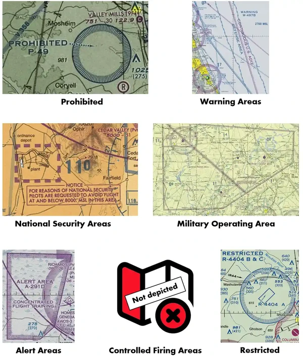
- Non-regulatory airspace areas include military operations areas (MOA), warning areas, alert areas, controlled firing areas (CFA), and national security areas (NSA).
- Non-regulatory airspace is a way to classify airspace and its associated purpose without subjecting it to the rulemaking process.
Types of Airspace
- There are four types of airspace:
- Controlled Airspace.
- Uncontrolled Airspace.
- Special Use Airspace.
- Other Airspace.
-
Controlled Airspace:
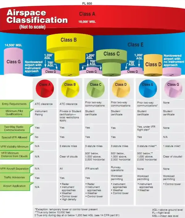
- Controlled airspace is a generic term that encompasses the different classifications of airspace and the defined dimensions within which air traffic control provides Instrument Flight Rules (IFR) and Visual Flight Rules (VFR) service, per the airspace classification. []
-
Uncontrolled Airspace:
- Uncontrolled or Class Golf Airspace areas are without air traffic controls but remain subject to overarching safety minimums outlined in FAA regulations. []
-
Special Use Airspace:
- Special Use Airspace (SUA) consists of defined dimensions identified by an area on the earth's surface wherein activities are confined because of their nature or wherein limitations are imposed upon aircraft operations that are not a part of those activities or both. []
- In those instances where security requirements dictate, the Federal Aviation Administration establishes prohibited airspace to completely segregate surface areas from flight operations.
- Like prohibited airspace, restricted airspace limits most flight operations but permits some when the controlling agency approves.
- Warning areas, MOAs, alert areas, CFAs, and NSAs are non-regulatory special use airspace.
- Special-use airspace descriptions (except CFAs) are contained in FAA Order JO 7400.8, Special Use Airspace.
- Permanent SUA (except CFAs) is charted on Sectional Aeronautical, VFR Terminal Area, and applicable En Route charts and includes the hours of operation, altitudes, and the controlling agency.
- For temporary restricted areas and temporary MOAs, pilots should review the Domestic Notices found on the Federal Notice to Airman System (FNS) website under External Links or the Air Traffic Plans and Publications website, the FAA SUA website, and/or contact the appropriate overlying ATC facility to determine the effect of non-depicted SUA areas along their routes of flight.
- The horizontal limits of special use airspace are the boundaries described by geographic coordinates or other appropriate references that clearly define their perimeter.
- The vertical limits of special-use airspace are the designated altitude floors and ceilings expressed as above mean sea level.
- Note that unless otherwise specified, the word "to" (an altitude or flight level) means "to and including" (that altitude or flight level).
- When operating within SUA, Air Traffic Control (ATC) assigned airspace (ATCAA), or altitude reservations (ALTRV), flights shall be conducted in accordance with the prescribed operational area procedures appropriate to the airspace and operation.
- SUA is technically separate and should not be confused with other airspace.
- Certain special use airspace areas can create limitations on the mixed-use of airspace.
- In conjunction with military operations, you may hear the term MARSA or Military Assumes Responsibility for Separation of Aircraft.
- This information is available on one of the end panels of National Aeronautical Navigation Products (AeroNav Products) en route charts.
- The FAA's Special Use Airspace Query page contains a list of current special-use airspaces.
- Special use airspace is divided into:
-
Regulatory Special Use Airspace:
-
Non-Regulatory Special Use Airspace:
-
Other Airspace:
- Other airspace is airspace that is neither standard nor special use.
- Other airspace is divided into:
-
Regulatory Other Airspace:
-
Non-Regulatory Other Airspace:

Airspace Rules, Regulations, and Procedures
-
Reduced Vertical Separation Minimum (RVSM):
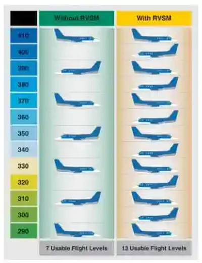
- The FAA established the Reduced Vertical Separation Minimum (RVSM) to accommodate heavy traffic while maintaining safety.
- Changing the separation above flight level (FL) 290 from 2,000' to 1,000' minimum adds six more flight levels while increasing equipment reliability and maintaining public safety. []
- Operators and aircraft must have received RVSM authorization from a responsible civil aviation authority.
- With requirements met and authorization obtained, pilots can utilize the benefits of RVSM airspace.
- Aircraft operating in the RVSM environment follow standard east (odd)/west (even) altitude routing for flights up to and including FL410.
- Pilots experiencing non-standard operating conditions, either with the aircraft or the environment, must follow specific procedures inside RVSM airspace.
- Under certain circumstances, aircraft may receive accommodation to operate non-RSVM aircraft in RSVM airspace.
-
Gulf of Mexico Flight Operations:
- Gulf of Mexico Flight Operations involve operations in the Gulf.
- Air traffic control (ATC) may apply 50 nautical miles (NM) lateral separation (i.e., lateral spacing) between airplanes authorized for Required Navigation Performance (RNP) 10 or RNP 4 operating in the Gulf of Mexico.
- 50 NM lateral separation may be applied in the following airspace:
- Houston Oceanic Control Area (CTA)/Flight Information Region (FIR).
- The Gulf of Mexico portion of the Miami Oceanic CTA/FIR.
- Monterrey CTA
- Merida High CTA within the Mexico FIR/UTA.
- Within the Gulf of Mexico airspace described above, pairs of airplanes whose flight plans indicate approval for Performance-Based Network (PBN) and either RNP 10 or RNP 4 may be spaced by ATC at lateral intervals of 50 NM.
- ATC will space any airplane without RNP 10 or RNP 4 capability such that at least 90 NM lateral separation is maintained with other airplanes in the Miami Oceanic CTA and at least 100 NM separation is maintained in the Houston, Monterrey, and Merida CTAs.
- The reduced lateral separation allows more airplanes to fly on optimum routes/altitudes over the Gulf of Mexico.
- 50 NM lateral separation is not applied on routes defined by ground navigation aids or Gulf Area Navigation (RNAV) Routes Q100, Q102, or Q105.
- Information useful for flight planning and operations over the Gulf of Mexico under this 50 NM lateral separation policy, as well as information on how to obtain RNP 10 or RNP 4 authorization, can be found in the West Atlantic, Gulf of Mexico, and Caribbean Resource Guide for U.S. Operators located at: https://www.faa.gov/headquartersoffices/avs/wat-gomex-and-caribbean-resource-guide.
- Pilots should use Strategic Lateral Offset Procedures (SLOP) during regular Gulf of Mexico CTA operations. SLOP procedures and limitations are published in the U.S. Aeronautical Information Publication (AIP), ENR Section 7.1, General Procedures; Advisory Circular (AC) 91-70, Oceanic and Remote Continental Airspace Operations; and International Civil Aviation Organization (ICAO Document 4444, Procedures for Air Navigation Services – Air Traffic Management.
-
Mode C Transponder Requirements:
- In general, the CFRs require aircraft to be equipped with an operable Mode C transponder and Automatic Dependent Surveillance-Broadcast (ADS-B) Out when operating:
- In Class A, Class B, or Class C airspace areas.
- Above the ceiling and within the lateral boundaries of Class B or C airspace up to 10,000 feet MSL.
- Class E airspace at and above 10,000 feet MSL within the 48 contiguous states and the District of Columbia, excluding the airspace at and below 2,500 feet AGL.
- Within 30 miles of a Class B airspace primary airport, below 10,000 feet MSL (commonly called the "Mode C Veil").
- For ADS-B Out: Class E airspace at and above 3,000 feet MSL over the Gulf of Mexico from the coastline of the United States out to 12 nautical miles.
- Transponder and ADS-B Out requirements do not apply to any aircraft not originally certificated with an electrical system, or that has not subsequently been certified with such a system installed, including balloons and gliders.
- These aircraft may conduct operations without a transponder or ADS-B Out when operating:
- Outside any Class B or Class C airspace area; and;
- Below the altitude of the ceiling of a Class B or Class C airspace area designated for an airport, or 10,000 feet MSL, whichever is lower.
- These aircraft may conduct operations without a transponder or ADS-B Out when operating:
- 14 CFR Section 99.13 requires all aircraft flying into, within, or across the contiguous U.S. ADIZ to have a Mode C or S transponder.
- Balloons, gliders, and aircraft not equipped with an engine-driven electrical system are exempt.
- Pilots must ensure that their aircraft transponder/ADS-B is operating on an appropriate ATC-assigned VFR/IFR code with altitude reporting enabled when operating in such airspace. If in doubt about the operational status of either feature of your transponder while airborne, contact the nearest ATC facility or FSS, and they will advise you on what facility you should contact to determine the status of your equipment.
- In general, the CFRs require aircraft to be equipped with an operable Mode C transponder and Automatic Dependent Surveillance-Broadcast (ADS-B) Out when operating:
-
Automatic Dependent Surveillance-Broadcast:
- Automatic Dependent Surveillance-Broadcast is surveillance technology deployed throughout the national airspace system.
- Position reports are based on satellite navigation systems (aircraft-to-aircraft).
- ADS-B broadcasts once per second with the aircraft's position, velocity, identification, and other information.
- It also receives this information from other aircraft.
- The ADS-B system is composed of aircraft avionics and a ground infrastructure.
- Onboard avionics determine the aircraft's position using the Global Navigation Satellite System (GNSS) and transmit it with additional information about the aircraft to ground stations for use by ATC and other ADS-B services (approximately once per second).
-
Unmanned Aircraft Systems Airspace:
- Small unmanned aircraft systems operations must be integrated into the NAS while maintaining operational capacity and safety without introducing an unacceptable risk to airspace users, persons, and property.
- 14 CFR Part 107 was the first new rule dedicated to UAS operations.
- For commercial operations, Part 135 and Part 137 considerations apply.
- Public aircraft operations are also permitted.
- When required, emergency operations are authorized.

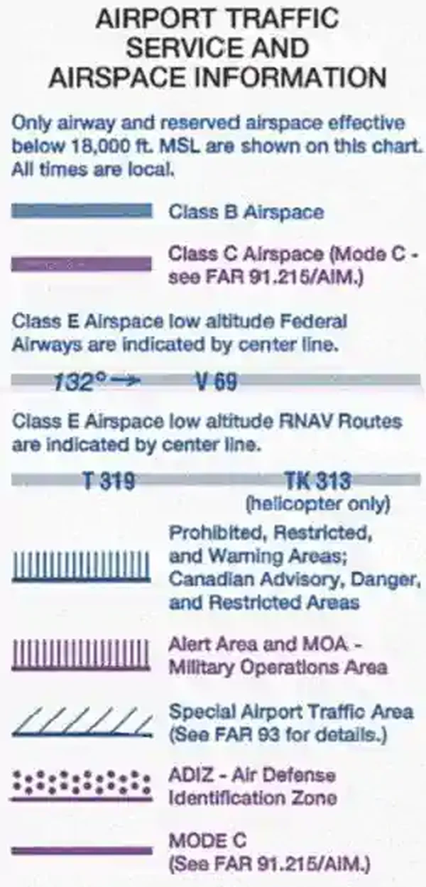
Airspace Charting
-
Controlled Airspace Charting: [
-
Class Alpha Airspace Charting:
Class Alpha airspace is not depicted on any chart but is assumed at FL180 and above. -
Class Bravo Airspace Charting:
Class Bravo airspace is depicted on VFR Sectionals, IFR En Route Low Altitude, Terminal Area Charts (where appropriate), and World Area Charts. -
Class Charlie Airspace Charting:
Class Charlie airspace is depicted on VFR Sectionals, IFR En Route Low Altitude, and Terminal Area Charts (where appropriate). -
Class Delta Airspace Charting:
Class Delta airspace is depicted on Sectional and Terminal charts, with blue segmented lines. -
Class Echo Airspace Charting:
Class Echo airspace is depicted on VFR Sectionals and Terminal Area Charts (where appropriate).
-
-
Uncontrolled Airspace Charting:
-
Class Golf Airspace Charting:
Class Golf airspace is not depicted on any chart.
-
-
Special Use Airspace Charting:
-
Prohibited Airspace Charting:
Prohibited airspace areas are depicted on aeronautical charts, including VFR sectionals and IFR en-route low-altitude charts. -
Restricted Airspace Charting:
Restricted airspace is depicted on aeronautical charts, including VFR sectionals and IFR en-route low-altitude charts. -
Alert Area Charting:
Alert areas are depicted on aeronautical charts, including VFR sectionals and IFR en-route low-altitude charts. -
National Security Areas Charting:
National security areas are depicted on aeronautical charts, including VFR sectionals and IFR en-route low-altitude charts. -
Military Operating Areas Charting:
Military Operating Areas are depicted on aeronautical charts, including VFR sectionals and IFR en-route low-altitude charts. -
Controlled Firing Area Charting:
Controlled Firing Areas are not depicted on aeronautical charts. -
Warning Areas Charting:
Warning Areas are depicted on aeronautical charts, including VFR sectionals and IFR en-route low-altitude charts.
-
-
Other Airspace Charting:
-
Temporary Flight Restrictions Charting:
Temporary flight restrictions are not usually depicted due to their short duration; however, they may occasionally be depicted on aeronautical charts, including VFR sectionals and IFR en-route low-altitude charts. -
Wildlife and Recreational Areas Charting:
Wildlife and recreational areas are depicted on VFR sectionals. -
Terminal Radar Service Area Charting:
Terminal radar service areas are depicted on VFR sectionals. -
Airport Advisory Area and Services Charting:
Airport Advisory Areas are not depicted. -
Military Training Routes Charting:
Military training routes are depicted on VFR sectionals and IFR en-route low-altitude charts. -
Parachute Jump Aircraft Area Charting:
Parachute jump areas are depicted with parachute icons on VFR sectionals. -
Published VFR Routes Charting:
Published VFR Routes are depicted on VFR sectionals and Terminal Area Charts. -
Air Defense Identification Zone Charting:
VFR sectionals and IFR en-route low-altitude charts depict air defense identification zones. -
Special Air Traffic Rules and Special Flight Rules Area Charting:
Special air traffic rules and special flight rules areas are charted on VFR sectionals and IFR en-route low-altitude charts. -
Weather Reconnaissance Area Charting:
Weather reconnaissance areas are not charted. -
Aircraft Hazard Areas Charting:
Aircraft hazard areas are not charted.
-

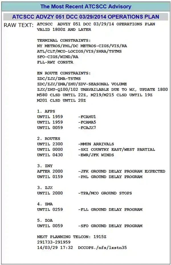
Operational Information System (OIS)
- The Operational Information System (OIS) is the FAA's Air Traffic Control System Command Center (ATCSCC) near-real-time national airspace system status information system. []
-
Advisories:
- Advisory messages are disseminated electronically by the ATCSCC. []
- Advisories are issued when the information is considered widely relevant.
- Advisories are not issued when information is valid for a short duration or is limited in scope.
- Advisory occasions include:
- Ground Stops.
- Ground Delay Programs.
- Route Information.
- Plan of Operations.
- Facility Outages and Scheduled Facility Outages.
- Volcanic Ash Activity Bulletins.
- Special Traffic Management Programs (Computerized Voice Reservation System (e-CVRS)/e-STMP.
- Advisory messages are disseminated electronically by the ATCSCC. []
-
Ground Stops:
- Ground stops are when aircraft are held on the ground and not allowed to take off.
- ATCSCC may issue ground stops for several reasons, including:
- To control air traffic volume at airports when the projected traffic demand exceeds the airport's acceptance rate for a short period.
- To temporarily stop traffic to allow time to implement a longer-term solution, such as a Ground Delay Program.
- The affected airport's acceptance rate drops to zero.
- The most widespread use of this procedure was on September 11, 2001.
-
Ground Delay Programs:
- The Ground Delay Program (GDP) is a traffic management process administered by the ATCSCC that involves holding aircraft on the ground.
- The program aims to support the traffic management mission and limit airborne holding.
- It is a flexible program, implemented in various forms depending on the needs of the air traffic system.
- Ground delay programs provide for equitable assignment of delays to all system users.
-
Route Information:
- Route information is available on the website and in specific advisories.
- Some route information, subject to the 56-day publishing cycle, is located on the "OIS" under "Products," Route Management Tool (RMT), and "What's New" Playbook.
- The RMT and Playbook contain routings for Air Traffic and NAS operators' use when coordinated "real-time," published in an ATCSCC advisory.
- The word "Route" in the header identifies route advisories; the associated action is Required (RQD), Recommended (RMD), Planned (PLN), or For Your Information (FYI).
- Operators are to file flight plans consistent with the Route RQD advisories.
-
Electronic System Impact Reports:
- Electronic System impact reports are available on the Operational Information System webpage under "System Impact Reports."
- This page lists scheduled outages/events/projects and Traffic Management Initiatives.

National Airspace System Conclusion
- The national airspace system's current configuration reflects technological advances in aircraft speed and altitude capabilities, as well as the complexity of microchips and satellite-based navigation equipment.
- It is of the utmost importance that aircraft remain within or clear of the specified vertical and horizontal limits of assigned airspace, as applicable.
- Remaining within a particular airspace can only be achieved by maintaining a thorough understanding of the details depicted in current charts, publications, and military directives, coupled with a continual assessment of the accuracy of the controlling agency's radar.
- Operating with self-imposed vertical and horizontal buffers may be required to remain within assigned airspace.
- When operating in SUA, military traffic must be cognizant of civilian aircraft that may not recognize the existence of such areas or monitor radio frequencies to receive appropriate warnings/advisories.
- Chapter 3 of the Aeronautical Information Manual and Part 71 of the Code of Federal Regulations (CFRs) provide dimensions, exceptions, geographical areas covered, exclusions, specific transponder or equipment requirements, and flight operation information.
- Pilots must be familiar with the operational requirements for each type or class of airspace.
- Refer to Title 14 of the U.S. Code of Federal Regulations (CFR) for specific dimensions, exceptions, geographical areas covered, exclusions, specific transponder/ADS-B or other equipment requirements, and flight operations.
- Regulatory airspace is established and governed through 14 CFR Part 73 through the rulemaking process.
- Refer to Title 14 of the U.S. Code of Federal Regulations (CFR) for specific dimensions, exceptions, geographical areas covered, exclusions, specific transponder/ADS-B or other equipment requirements, and flight operations.
- When overlapping airspace designations apply to the same airspace, the operating rules associated with the more restrictive airspace designation apply.
- NAS operators can access the OIS website at https://www.fly.faa.gov before filing their flight plan.
- This information is useful for pre-flight planning, but remember, updates are published on a workload-permitting basis.
- Not commonplace, there are other airspace designations, such as waivered airspace, that pilots may hear about but are impractical for everyday flight operations.
- The United States adopted the primary elements of the ICAO classification system to conform to international aviation standards.
- Read the FAA's guidance on entering, exiting, and flying in United States airspace to learn more about international flying.
- Various air traffic control services are provided within controlled airspace, including:
- Traffic advisories are provided to all aircraft as the controller's work situation permits.
- However, air traffic control provides safety alerts to ALL aircraft.
- Resources, such as AOPA's Know Before You Go: Navigating Today's Airspace, are available to help learn about the national airspace system and how to navigate it best.
- Still looking for something? Continue searching:
National Airspace System References
- Federal Aviation Administration - Pilot/Controller Glossary.
- AOPA - Airspace at a Glance.
- AOPA - Know Before You Go: Navigating Today's Airspace.
- Aeronautical Information Manual (3-1-1) General.
- Aeronautical Information Manual (3-1-2) General Dimensions of Airspace Segments.
- Aeronautical Information Manual (3-1-3) Hierarchy of Overlapping Airspace Dimensions.
- Aeronautical Information Manual (3-2-1) General Airspace.
- Aeronautical Information Manual (Section 4) Special Use Airspace.
- Aeronautical Information Manual (Section 5) Other Airspace Areas.
- AeroNav Products - Aeronautical Chart User's Guide.
- FAA Order JO 7400.2G, Procedures for Handling Airspace Matters
- FAA Order (8260.19) Flight Procedures and Airspace.
- FAA Order (7400.8) Special Use Airspace.
- Federal Aviation Administration Order (JO 7400.11A) Airspace Designations and Reporting Points.
- Federal Aviation Regulations (71.9) Overlapping airspace designations.
- Federal Aviation Regulations (73.1) Applicability.
- Federal Aviation Regulations (73.3) Special Use Airspace.
- Instrument Flying Handbook (1-2) Airspace Classification.
- FAA - National Airspace System.
- Federal Aviation Administration Order (7400.9) Airspace Designations and Reporting Points.
- Federal Aviation Regulations (Part 71) Designation of Class A, B, C, D, and E Airspace Areas; Air Traffic Service Routes; and Reporting Points.
- Federal Aviation Regulations (91.155) Basic VFR Weather Minimums.
- Pilot Handbook of Aeronautical Knowledge (14-1) Airspace.
- AOPA Air Safety Institute - Airspace Flash Cards.