Controlled Airspace
Controlled airspace is organized by classification, operating rules, pilot requirements, and air traffic control services.
Introduction to Controlled Airspace
- Controlled airspace is the portion of the National Airspace System where air traffic control provides separation and traffic services.
- Beginning with the high-altitude structure, Class Alpha Airspace contains strictly IFR operations.
- Surrounding the nation’s busiest airports, Class Bravo Airspace manages dense traffic volumes through a layered structure and strict ATC clearance requirements for aircraft entering the airspace.
- Large commercial airports with significant airline traffic typically operate within Class Charlie Airspace, where ATC provides sequencing and separation services for both IFR and participating VFR aircraft.
- Many smaller towered airports are surrounded by Class Delta Airspace, which organizes local airport traffic and ensures safe aircraft operations in the terminal environment.
- Filling the gaps between other airspace classifications, Class Echo Airspace provides controlled airspace for IFR operations and supports aircraft transitioning between terminal areas and the en route structure.
- When you have a solid understanding of Controlled Airspace, compare your knowledge against the Private Pilot (Airplane), Commercial Pilot (Airplane), or Small Unmanned Aircraft Systems Airman Certification Standards.
Controlled Airspace Key Highlights
- Controlled airspace is airspace where air traffic control services are provided to support safe and efficient aircraft operations.
- Controlled airspace classifications include Class A, B, C, D, and E airspace within the National Airspace System.
- Air traffic control separation services vary depending on the airspace class, aircraft type, and flight rules being used.
- Controlled airspace often surrounds busy airports, airways, terminal environments, and high-altitude flight operations.
- Pilots operating in controlled airspace may be required to establish radio communication, receive clearances, or use transponders and ADS-B equipment.
- Weather minimums, visibility requirements, and equipment standards differ among controlled airspace classifications.
- Instrument flight rules (IFR) operations rely heavily on controlled airspace structure and ATC coordination.
- Controlled airspace improves traffic organization, collision avoidance, and operational efficiency within congested aviation environments.
- Pilots should review charts, NOTAMs, and airspace requirements carefully before operating within controlled airspace.
- Understanding controlled airspace improves regulatory compliance, situational awareness, and overall flight safety.
Class Alpha Airspace
- Class Alpha (also called "Class A") Airspace is positive control airspace, meaning Air Traffic Control (ATC) can see and track aircraft.
- Radar services are provided to aircraft operating under Instrument Flight Rules (IFR).
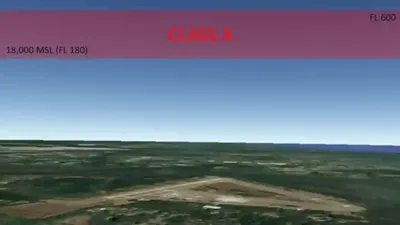
- Class alpha airspace encompasses the high-altitude enroute environment, containing "cruise altitudes" or "Flight Levels" (FL) in the United States.
- Given its expansive dimensions, navigation charts omit depictions.
- Operations in Class Alpha airspace require adherence to relevant operating rules & pilot equipment requirements.
- ATC may grant authorizations to deviate from operating and equipment requirements when the situation permits.
-
Class Alpha Airspace Air Traffic Services:
- Pilots operating in Class Alpha are operating on an instrument flight clearance and therefore provided services in accordance.
- When pilots are operating VFR on top, the pilot is responsible to fly at an appropriate VFR altitude, comply with VFR visibility and distance from cloud criteria, and to be vigilant so as to see and avoid other aircraft.
- The pilot is also responsible to comply with instrument flight rules applicable to the flight (e.g., adherence to ATC clearances).
- Although IFR separation is not applied, controllers must continue to provide traffic advisories and safety alerts, and apply merging target procedures to aircraft operating VFR‐on‐top.
-
Class Alpha Airspace Dimensions:
- Vertically, Class Alpha begins at 18,000' Mean Sea Level (MSL) up to and including FL600 (about 60,000' MSL). []
- Horizontally, Class Alpha begins when within 12 Nautical Miles (NM) of the coast in 48 contiguous states and Alaska and designated international airspace beyond 12 NM off the coast of the 48 contiguous States and Alaska within areas of domestic radio navigational signal or ATC radar coverage, and within which domestic procedures apply.
- Examples include Santa Barbara Island, Farallon Islands, and airspace south of latitude 25°04'00" North.
- Class Alpha airspace does not include the airspace less than 1,500 feet above the earth's surface and the Alaska Peninsula west of longitude 160°00'00" West.
-
Class Alpha Airspace Depiction:
- Navigation charts omit Class A airspace depictions. []
-
Class Alpha Airspace Operating Rules & Pilot/Equipment Requirements:
-
Pilot Qualifications:
-
VFR Visibility Requirements:
- Unless otherwise authorized, each person operating an aircraft in Class A airspace must conduct operations under Instrument Flight Rules (IFR).
- See 14 Code of Federal Regulations (FAR) Section 71.33, Sections 91.167 through 91.193, Sections 91.215 through 91.217, and Sections 91.225 through 91.227.
- Unless otherwise authorized, each person operating an aircraft in Class A airspace must conduct operations under Instrument Flight Rules (IFR).
-
Entry Requirements:
- IFR Clearance.
- IFR flight plan.
- IFR-equipped aircraft.
- Two-way radio communications.
- Unless otherwise authorized by ATC, a 91.215.
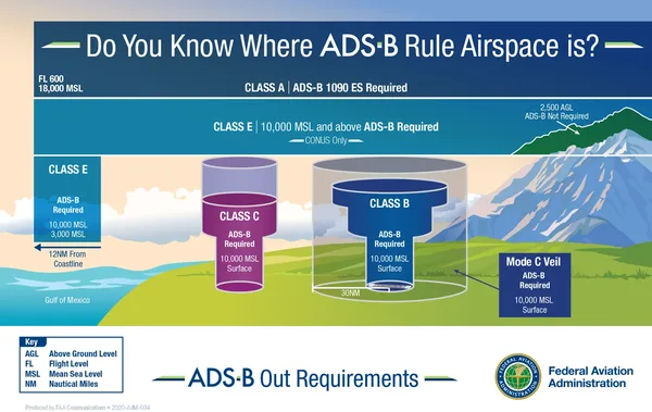
- After January 1, 2020, the applicable Automatic Dependent Surveillance-Broadcast (ADS-B) Out equipment specified in 91.225.
- If navigating above 24,000', aircraft require VHF Omni-Directional Range (VOR) and Distance Measuring Equipment (DME).
-
Equipment Requirements:
-
Transponder:
- Unless otherwise authorized by ATC, an operable radar beacon transponder with automatic altitude reporting capability and operable ADS-B Out equipment. []
-
Communication Equipment:
- Two-way radio communications with the controlling agency (described below) are required.
-
-
ATC Clearances & Separation:
-
ATC Facility:
- Air Route Traffic Control Center (ARTCC).
- Also known as "center."
- Example: "Atlanta center."
- Pilots require an ATC clearance before entering Class Alpha airspace.
- Air Route Traffic Control Center (ARTCC).
- Separation standards are applied and provided for all aircraft.
- Pilots must change their altimeter setting from the local altimeter to 29.92 when climbing through 18,000 feet.
- Setting 29.92 ensures all aircraft flying in Class A airspace have the same altimeter setting and will have proper altitude separation.
- Non-Reduced Vertical Separation Minima (RVSM) separation is 2,000' vertically.
- RVSM separation is 1,000' vertically.
-
-
Jet & Q Route Systems:
-
Jet Route System:
- Similar to the Victor route system, the jet route system consists of jet routes established from 18,000' MSL to FL 450 inclusive.
- These routes are depicted on Enroute High Altitude Charts.
- Depicted in black on aeronautical charts.
- Identified by a "J" (Jet) followed by the airway number (e.g., J12).
- Jet routes, as VOR airways, are predicated solely on VOR or VORTAC navigation facilities (except in Alaska).
- Segments of jet routes in Alaska are based on L/MF navigation aids and are charted in brown color instead of black on en route charts.
- Operation above FL 450 may be conducted on a point-to-point basis.
- Navigational guidance is provided on an area basis utilizing those facilities depicted on the enroute high altitude charts
- With respect to position reporting, reporting points are designated for jet route systems. Flights using jet routes will report over these points unless otherwise advised by ATC.
- Note the range of Jet Routes may be limited due to Standard Service Volume (SSV) of ground stations. []
- Jet routes have no defined width.
- A Navigational Aid (NAVAID) on a continuing jet route is NOT part of the segment and should not be included in your flight plan.
- Similar to the Victor route system, the jet route system consists of jet routes established from 18,000' MSL to FL 450 inclusive.
-
Q Route System:
- Q-Routes are available for use by RNAV-equipped aircraft between 18,000' MSL and FL450 (about 45,000'), the same as J Routes.
- Enroute High Altitude Charts depict Q Routes. []
- Operations above FL450 (about 45,000') are permitted point-to-point.
- RNAV routes are established in low-altitude and high-altitude structures, depicted on the enroute low and high chart series.
- High-altitude RNAV routes are identified with a "Q" prefix (except the Q-routes in the Gulf of Mexico), and low-altitude RNAV routes are identified with a "T" prefix.
- RNAV routes and data are depicted in aeronautical blue.
- In addition to the published routes, pilots may fly random RNAV routes under IFR if ATC approves.
- Random RNAV routes are direct routes, based on RNAV capability, between waypoints defined in terms of latitude/longitude coordinates, degree-distance fixes, or offsets from established routes/airways at a specified distance and direction.
- ATC is required to radar monitor random RNAV routes.
- Approval for these routes requires a radar environment.
- ATC considers factors in approving random RNAV routes, including the capability to provide radar monitoring and compatibility with traffic volume and flow.
- ATC will radar monitor each flight; however, pilots are responsible for navigating the random RNAV route.
-
-
-
Class Alpha Airspace Conclusion:
- Federal Aviation Regulation 91.155 governs VFR ceiling and visibility minimums.
- ATC assigns altitudes based on pressure altitude (synonymous with Flight Level), which means pilots shall set altimeters to the standard of 29.92 inHg.
- The use of the standard 29.92 has several implications you must understand.
- The only airspace not depicted on sectional charts is Class Alpha airspace.
- There is no Class A airspace over Hawaii, and Victor Airways has no upper limit in Hawaii.
- To learn more about flight planning and navigation tools, check out:
- Reduced Vertical Separation Minimum (RVSM) begins at FL290 and extends to FL410.


Class Bravo Airspace
- Class Bravo (also called "Class B") Airspace surrounds the nation's "busiest" airports like New York, San Francisco, Atlanta, etc.
- To safely manage this significant volume of traffic, Air Traffic Control provides several services to arriving and departing aircraft via the Air Traffic Control Tower (ATCT) and Terminal Radar Approach Control (TRACON).
- Individually tailored, and depicted as an upside-down wedding cake, Class Bravo airspace design ensures relevant operations are contained and services are consistent throughout.
- Operations in Class Bravo airspace require adherence to relevant operating rules & pilot equipment requirements.
- Class Bravo Airspace surrounds airports with at least an operational Air Traffic Control Tower (ATCT) and Terminal Radar Approach Controls (TRACON).
-
Class Bravo Airspace Air Traffic Services:
- Class Bravo Airspace supports Instrument Flight Rules (IFR) and Visual Flight Rules (VFR) operations.
- Class Bravo Airspace air traffic services are provided by Air Traffic Control Towers (ATCTs) and Terminal Radar Approach Controls (TRACON).
-
Approach Control Service for VFR Arriving Aircraft:
- Numerous approach control facilities have established programs for arriving VFR aircraft to contact approach control for landing information.
- This information includes wind, runway, and altimeter setting at the airport of the intended landing.
- If contained in the Automatic Terminal Information Service (ATIS) broadcast and the pilot states the appropriate ATIS code, Air Traffic Control (ATC) omits this information.
- The pilot's use of "have numbers" does not indicate receipt of the ATIS broadcast. In addition, the controller will provide traffic advisories on a workload-permitting basis.
- Such information will be furnished upon initial contact with the concerned approach control facility.
- ATC will request the pilot change to the tower frequency at a predetermined time or point to receive further landing information.
- Where available, this procedure will not hinder the operation of VFR flights by requiring excessive spacing between aircraft or devious routing.
- Compliance with this procedure is not mandatory, but pilot participation is encouraged.
- Approach control services for VFR aircraft are normally dependent on ATC radar. These services are not available during periods of a radar outage.
- Numerous approach control facilities have established programs for arriving VFR aircraft to contact approach control for landing information.
-
Class Bravo Airspace Dimensions:
- Class Bravo airspace's vertical and lateral limits are individually tailored and designated for operational needs, runway alignment, adjacent regulatory airspace, or adjacent airports and contain all instrument procedures.
-
Class Bravo Airspace Lateral Limits:
- The outer limits of the airspace do not exceed a 30 Nautical Mile (NM) radius from the primary airport. []
- This 30 NM radius is typically divided into three concentric circles: an inner 10 NM radius, a middle 20 NM radius, and an outer 30 NM radius.
- The areas between 10 to 20 NM and 20 to 30 NM may be vertically subdivided because of terrain or other regulatory airspace.
-
Class Bravo Airspace Vertical Limits:
- Generally extends from surface to 10,000' MSL with some exceptions (Atlanta) around the nation's busiest airports. []
- It consists of a surface area and two or more layers (some Class B airspace areas resemble upside-down wedding cakes).
- The inner 10 NM area must normally extend from the surface to the upper limits of the airspace.
- This segment may be adjusted to coincide with runway alignment, adjacent airports, other regulatory airspace, etc., to encompass all final approach fixes and minimum altitudes at the final approach fix.
- The floor between 10 and 20 NM is predicated on a 300-foot per NM gradient for 10 NM. This segment normally has a floor between 2,800 and 3,000 feet above the airport elevation.
- This floor must remain constant for that segment but may be adjusted considering the terrain and adjacent regulatory airspace.
- The floor between 20 and 30 NM must be at an altitude consistent with approach control arrival and departure procedures.
- This floor is normally between 5,000 and 6,000 feet above the airport elevation.
- In the segment between 20 and 30 NM, exclusions are permitted to accommodate adjacent regulatory airspace and/or terrain.
- Satellite Airports:
- The adverse effects on satellite airport operations and operations at the primary airport are considered when establishing the airspace floor.
- If not required, the Class B airspace excludes airspace directly over a satellite airport.
- Unique published traffic patterns and/or procedures may be required for satellite airports.
-
Class Bravo Airspace Depiction:
- The following charts depict Class Bravo airspace: []
- VFR Sectionals.
- IFR En Route Low Altitude and;
- Terminal Area Charts (where appropriate).
- World Area Charts
- The FAA publishes enhanced Class B graphics, which are available for download.
- The following charts depict Class Bravo airspace: []
-
Class Bravo Airspace Operating Rules & Pilot/Equipment Requirements:
-
Class Bravo Airspace Pilot Certification Requirements:
- No person may take off or land a civil aircraft at an airport within a Class B airspace area or operate a civil aircraft within a Class B airspace area unless:
- The pilot in command holds at least a private pilot certificate;
- The pilot-in-command holds a recreational pilot certificate and has met the requirements of 14 Code of Federal Regulations (CFR) Section 61.101, or (c) The pilot-in-command holds a sport pilot certificate and has met the requirements of 14 CFR Section 61.325; or.
- A student pilot operates the aircraft:
- Who seeks a private pilot certificate and.
- Has met the requirements of 14 CFR Section 61.95.
- Who seeks a recreational pilot certificate or sport pilot and has met the requirements of 14 CFR Section 61.94.
- Note that some class B airports prohibit student pilots, as shown below.
- Who seeks a private pilot certificate and.
- No person may take off or land a civil aircraft at the following primary airports within Class B airspace unless the pilot-in-command holds at least a private pilot certificate:
- Andrews Air Force Base, MD.
- Atlanta Hartsfield Airport, GA.
- Boston Logan Airport, MA.
- Chicago O'Hare Int'l. Airport, IL.
- Dallas/Fort Worth Int'l. Airport, TX.
- Los Angeles Int'l. Airport, CA.
- Miami Int'l. Airport, FL.
- Newark Int'l. Airport, NJ.
- New York Kennedy Airport, NY.
- New York La Guardia Airport, NY.
- Ronald Reagan Washington National Airport, DC.
- San Francisco Int'l. Airport, CA.
- Federal Aviation Regulation (FAR) 61.95 identifies a different but similar list for recreational and sport pilots.
- No person may take off or land a civil aircraft at an airport within a Class B airspace area or operate a civil aircraft within a Class B airspace area unless:
-
Class Bravo Airspace VFR Visibility Requirements:
- 3 Statute Mile (SM) visibility and clear of clouds.
-
Class Bravo Airspace Entry Requirements:
- Regardless of weather conditions, an ATC clearance is required for all aircraft to operate inside of Class Bravo airspace.
- All aircraft will receive separation services within the airspace.
- An ATC clearance is recognized by hearing "cleared."
- YOU: "[Callsign], [Location], with [Information], request."
- ATC: "[Callsign], [Agency], cleared to [Clearance], [Restrictions]."
- Unlike Class Charlie or Delta, if you hear your callsign followed by "Standby" or any other variation that does not have the word "Cleared," then you have established two-way communication but do not have permission to enter the airspace.
- An ATC clearance is recognized by hearing "cleared."
-
Class Bravo Airspace Equipment Requirements:
-
Class Bravo Airspace Transponder Requirements:
- Unless otherwise authorized by ATC, an operable radar beacon transponder (within 30 NM) with automatic altitude reporting capability and operable Automatic Dependent Surveillance-Broadcast (ADS-B) Out equipment. []
-
Class Bravo Airspace Communication Equipment Requirements:
- Two-way radio communications with the controlling agency (described below) are required.
-
-
ATC Clearances & Separation:
- An ATC clearance is required to enter and operate within Class B airspace.
- ATC provides sequencing and separation for VFR pilots from other aircraft operating within Class B airspace.
- Separation and sequencing of VFR aircraft will be suspended in the event of a radar outage, as this service is dependent on radar. ATC will advise the pilot if the service is unavailable and issue wind and runway information and the time or place to contact the tower.
- ATC separates VFR aircraft from all VFR/IFR aircraft which weigh 19,000 pounds or less by a minimum of:
- Target resolution or;
- 500' vertical separation or;
- Visual separation.
- ATC separates VFR aircraft from all VFR/IFR aircraft which weigh more than 19,000 and turbojets by no less than:
- 1 1/2 miles lateral separation or;
- 500' vertical separation or;
- Visual separation.
- This program is not to be interpreted as relieving pilots of their responsibilities to:
- See and avoid other traffic operating in basic VFR weather conditions;
- Adjust their operations and flight path as necessary to preclude serious wake encounters;
- Maintain appropriate terrain and obstruction clearance or;
- Remain in weather conditions equal to or better than the minimums required by 14 CFR Section 91.155.
- When compliance with an assigned route, heading, and/or altitude is likely to compromise terrain and obstruction clearance, vortex exposure, and weather minimums, pilots must advise approach control for a revised clearance or instruction.
- ATC may assign altitudes to VFR aircraft that do not conform to 14 CFR Section 91.159.
- When altitude assignments are unnecessary for separation or when leaving Class B airspace, ATC will broadcast "resume appropriate VFR altitudes "Resume Appropriate VFR Altitudes."
- Pilots must return to an altitude that conforms to 14 CFR Section 91.159.
- Not to relieve pilots of their responsibilities to see and avoid.
- Class B airspace is the only airspace where ATC separates VFR traffic from other VFR traffic.
-
Mode C Veil:
- The Mode C Veil is that airspace generally within 30 nautical miles of primary airports within Class B airspace areas, from the surface upward to 10,000' MSL.
- Unless otherwise authorized by ATC, aircraft operating within this airspace must have an operable radar beacon transponder with automatic altitude reporting capability and operable ADS-B Out equipment.
- Aircraft not originally certificated with an engine-driven electrical system or that have not subsequently been certified with a system installed may conduct operations within a Mode C veil provided the aircraft remains outside Class A, B, or C airspace and below the altitude of the ceiling of a Class B or Class C airspace area designated for an airport or 10,000' MSL, whichever is lower.
-
Flight Procedures:
- Aircraft within Class B airspace are required to operate in accordance with current IFR procedures.
- A clearance for a visual approach to a primary airport is not authorization for turbine-powered airplanes to operate below the designated floors of the Class B airspace.
-
VFR Flights:
- Arriving aircraft must obtain an ATC clearance before entering Class B airspace and contact ATC on the appropriate frequency in relation to geographical fixes shown on local charts.
- Although a pilot may be operating beneath the floor of the Class B airspace on initial contact, communications with ATC should be established in relation to the points indicated for spacing and sequencing purposes.
- Departing aircraft require clearance to depart Class B airspace and should advise the clearance delivery position of their intended altitude and route of flight.
- ATC will normally advise VFR aircraft when leaving the geographical limits of the Class B airspace.
- Radar service is not automatically terminated with this advisory unless specifically stated by the controller.
- Aircraft not landing or departing the primary airport may obtain an ATC clearance to transit the Class B airspace when traffic conditions permit, provided the requirements of 14 CFR Section 91.131 are met.
- Such VFR aircraft are encouraged, to the extent possible, to operate at altitudes above or below the Class B airspace or transit through established VFR corridors.
- Pilots operating in VFR corridors should use a frequency of 122.750 MHz to exchange aircraft position information.
- Arriving aircraft must obtain an ATC clearance before entering Class B airspace and contact ATC on the appropriate frequency in relation to geographical fixes shown on local charts.
- Large turbine engine-powered aircraft operations to or from a primary airport shall operate at or above the designated floors while within the limits of Class B airspace.
- A visual clearance to land is not an authorization for turbine-powered airplanes to operate below designated floors.
-
Proximity Operations:
- VFR aircraft operating in proximity to Class B airspace are cautioned against operating too closely to the boundaries, especially where the floor of the Class B airspace is 3,000 feet or less above the surface or where VFR cruise altitudes are at or near the floor of higher levels.
- Observance of this precaution will reduce the potential for encountering an aircraft operating at the altitudes of Class B floors.
- Additionally, VFR aircraft are encouraged to utilize the VFR Planning Chart to plan flights near Class B airspace.
- Charted VFR Flyway Planning Charts are published on the back of the existing VFR Terminal Area Charts.
-
Speed Restrictions:
- FAR 91.117 limits airspeed inside of Class Bravo Airspace to 250 knots.
- FAR 91.117 limits airspeed below Class Bravo Airspace or in a Class Bravo Airspace Corridor to 200 knots.
-
Small Unmanned Aircraft Operations:
- No person may operate a small unmanned aircraft in Class B unless that person has prior authorization from Air Traffic Control (ATC).
- Authorization may be obtained through the FAA's UAS data exchange, Low Altitude Authorization and Notification Capability (LAANC), or the FAA's DroneZone.
- No person may operate a small unmanned aircraft in a manner that interferes with operations and traffic patterns at any airport, heliport, or seaplane base.
- No person may operate a small unmanned aircraft in Class B unless that person has prior authorization from Air Traffic Control (ATC).
-
-
Class Bravo Airspace Knowledge Quiz;

 .
.
-
Class Bravo Airspace Conclusion;
- Federal Aviation Regulation 91.155 governs VFR ceiling and visibility minimums.
- Aircraft not landing or departing the primary airport may obtain a clearance to transit the airspace when traffic conditions permit, provided FAR 91.131 is met.
- Encouraged to operate above or below the airspace or transit VFR corridors, making position reports on 122.750 MHz.
- Balance shortening your callsign vs. clarity when there can easily be multiple people using the same "number" or however it is abbreviated.
- Example: Southern California with all military traffic "01," "22," etc.
- Regardless of weather, pilots should not request a clearance to operate within Class B airspace unless the requirements of 14 CFR Section 91.215 and 14 CFR Section 91.131, 91.215, and 91.225 are met.
- Remember to comply with all noise abatement procedures in the Chart Supplement U.S..
- ATC may, upon notification, immediately authorize a deviation from the altitude reporting equipment requirement; however, a request for a deviation from the 4096 transponder equipment requirement must be submitted to the controlling ATC facility at least one hour before the proposed operation. A request for a deviation from the ADS-B equipage requirement must be submitted using the FAA's automated web authorization tool at least one hour but not more than 24 hours before the proposed operation.
- No person may operate an aircraft within a Class B airspace area except in compliance with FAR 91.129 and 91.131.
- The operator must receive an ATC clearance from the ATC facility with jurisdiction over that area before operating an aircraft.
- Unless otherwise authorized by ATC, each person operating a large turbine engine-powered airplane to or from a primary airport within a Class B airspace area must operate at or above the designated floors of the Class B airspace area while within the lateral limits of that area.
- Any person conducting pilot training operations at an airport within a Class B airspace area must comply with any procedures established by ATC for such operations in that area.
- Departing from an airport in Class Bravo airspace can be very intimidating, especially single-piloted.
- If IFR, pilots typically fly a published Standard Instrument Departure Procedure (SID) instead of radar vectors.
- If VFR, pilots typically fly standard departure paths.
- Local pilots, Fixed-Base Operators (FBOs), or ATCs can tell you in advance via phone.
- If departing under class Bravo, you do not need to comply with any of class Bravo restrictions, except for having an altitude encoding transponder unless exempt.
- If departing inside of class Bravo, you must follow the departure per the tower and contact class Bravo as soon as instructed for further clearance.
- See also:
- Still looking for something? Continue searching:


Class Charlie Airspace
- Class Charlie (also called "Class C") Airspace areas are designed to improve aviation safety by reducing the risk of midair collisions in the terminal area and enhancing the management of air traffic operations therein.
- Air Traffic Control (ATC) provides services to arriving and departing aircraft via the Air Traffic Control Tower (ATCT) and Terminal Radar Approach Control (TRACON) under both Visual and Instrument Flight Rules (VFR/IFR).
- These air traffic control agencies provide services that apply whenever operating within Class C airspace, as depicted on various aeronautical charts.
- To manage these services, ATC has established operational requirements that the pilot must meet to operate within the airspace.
- When other airports fall within the airspace dimensions as the primary airports, they are considered satellite airports.
-
Class Charlie Airspace Air Traffic Services:
- ATC provides air traffic services once two-way radio communications and radar contact is established.
- All VFR aircraft are:
- Sequenced to the primary airport.
- Provided Class C services within the Class C airspace and the outer area.
- Provided basic radar services.
- VFR aircraft can expect these services on a workload-permitting basis.
-
Approach Control Service for VFR Arriving Aircraft:
- Numerous approach control facilities have established programs for arriving VFR aircraft to contact approach control for landing information, including:
- Wind;
- Runway, and;
- Altimeter setting at the airport of intended landing.
- When the pilot states the appropriate Automatic Terminal Information Service (ATIS) code, ATC will omit information in the ATIS broadcast.
- The pilot's use of "have numbers" does not indicate receipt of the ATIS broadcast.
- In addition, the controller will provide traffic advisories on a workload-permitting basis.
- Upon initial contact with the concerned approach control facility, such information will be furnished.
- ATC will instruct the pilot to change the tower frequency at a predetermined time or point to receive further landing information.
- Where available, this procedure will not hinder the operation of VFR flights by requiring excessive spacing between aircraft or devious routing.
- Compliance with this procedure is not mandatory, but pilot participation is encouraged.
- Approach control services for VFR aircraft are normally dependent on ATC radar. These services are not available during periods of a radar outage.
- Numerous approach control facilities have established programs for arriving VFR aircraft to contact approach control for landing information, including:
-
Class Charlie Airspace Dimensions:
- Class C airspace area locations must include a single primary airport around which the designated Class C airspace.
- However, due to its size, it may encompass other airports, referred to as secondary airports.
-
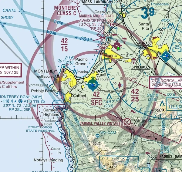
Horizontal Limits:
- Class C airspace areas are generally designed as two circles centered around the primary airport. []
- The inner core has a radius of 5 nautical miles (NM).
- The shelf area has a radius of 10 NM.
- Solid magenta lines identify the horizontal boundaries of class C airspace.
- Class C airspace areas are generally designed as two circles centered around the primary airport. []
-
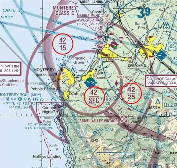
Vertical Limits:
- The ceiling of a Class C airspace should be 4,000 feet Above Ground Level (AGL) above the primary airport's field elevation.
- The inner core spans from the surface to 4000' AGL.
- The shelf area spans from 1,200' AGL (no lower) to 4,000'.
- Magenta numbers or letters identify the vertical boundaries of class C airspace. []
- The altitude above the magenta line is the ceiling, while the altitude below is the floor.
- Altitude dimensions are based on AGL but charted in Mean Sea Level (MSL).
- The ceiling of a Class C airspace should be 4,000 feet Above Ground Level (AGL) above the primary airport's field elevation.
- In congested areas, Class Charlie airspace may be bound against others, such as Class Bravo airspace.
- When this is the case, airspace designations will denote where the transition altitude is by designating a surface altitude and a "T," which denotes the ceiling is up to, but not including, the floor of Class Bravo airspace. []
- Orlando Executive Airport (Class B), for example, bumps against Orlando Sanford Airport (Class C), which requires reference to the Class Bravo airspace to determine the ceiling of Class Charlie. []
- Though not requiring regulatory action, an outer area is a procedural companion to Class C airspace.
- This area is usually 20 NM from the primary Class C airspace airport.
- The typical radius of an outer area is 20 NM from the primary Class C airspace airport.
- Its vertical limit extends from the lower radio/radar coverage limits up to the ceiling of the approach control's delegated airspace, excluding Class C and other airspace as appropriate.
- This outer area is NOT depicted and imposes no limitation on pilots.
- Pilot participation is voluntary within the outer area.
- Class C services are provided in the outer area unless the pilot requests termination of the service.
- Other locations may not have standard rings or standard altitudes, which require attention to actual airspace dimensions, both vertical and lateral. []
- Class C airspace area locations must include a single primary airport around which the designated Class C airspace.
-
Class Charlie Airspace Depiction:
- Class Charlie airspace is depicted on the following charts: []
- VFR Sectionals;
- IFR En Route Low Altitude and;
- Terminal Area Charts (where appropriate).
- Class Charlie airspace is depicted on the following charts: []
-
Class Charlie Airspace Operating Rules & Pilot/Equipment Requirements:
-
Pilot Certification Requirements:
- No specific pilot certification is required, meaning if an aircraft meets the equipment requirements below, anyone from a student and up can operate within Class Charlie Airspace.
-
VFR Visibility Requirements:
- If the pilot is operating under VFR, then they must have at least 3 Statute Miles visibility and be able to maintain 500' below, 1,000' above, and 2,000' horizontal of any clouds.
-
Equipment:
-
Transponder:
- Unless otherwise authorized by ATC, when operating within or above Class Charlie airspace, a transponder in compliance with 91.215 and operable Automatic Dependent Surveillance-Broadcast (ADS-B) Out equipment is required. []
- When below Class Charlie airspace, a transponder is not required as it is for Class Bravo.
-
Communication Equipment:
- Radios are required to maintain two-way radio communications with the controlling agency (described below).
-
-
Aircraft Separation:
- ATC provides separation within the Class C airspace and the outer area after establishing two-way radio communications and radar contact.
- ATC separates IFR from VFR aircraft at all times.
- VFR aircraft are separated from IFR aircraft within the Class C airspace by any of the following:
- Visual separation;
- 500' vertical separation or;
- Target resolution.
- Wake turbulence separation will be provided to all aircraft operating:
- Behind and less than 1,000 feet below super or heavy aircraft;
- To small aircraft operating behind and less than 500 feet below B757 aircraft and;
- To small aircraft following a large aircraft on final approach.
- Separation and sequencing of VFR aircraft will be suspended in the event of a radar outage, as this service is dependent on radar.
- ATC will advise pilots if the service is unavailable, issue wind and runway information, and the time or place to contact the tower.
- Some facilities provide Class C services only during published hours.
- At other times, terminal IFR radar service will be provided.
- It is important to note that the communications and transponder/ADS-B requirements depend on the airspace class established outside the published hours.
-
Flight Procedures:
-
Arrival:
- Pilots must establish two-way radio communication with Air Traffic Control before entry and maintain those communications while in Class C airspace.
- Pilots of arriving aircraft should contact the Class C airspace ATC facility on the publicized frequency and give their position, altitude, radar beacon code, destination, and request Class C service.
- This is a lot of information to contact a controller; they may not be ready.
- Consider the use of a "cold call" first:
- Pilot: "[Agency], [Callsign], Request."
- Once the controller responds, give them the full call.
- Pilot: "[Agency], [Position], [Altitude], [Transponder Code], [Destination], [Request]."
- ATC: "[Callsign] report [Instructions]."
- Radio contact should be initiated far enough from the Class C airspace boundary to preclude entering Class C airspace before establishing two-way radio communications.
- Permission is recognized by hearing your call sign:
- ATC: "Aircraft calling, standby."
- A controller must respond to the initial radio call using the aircraft's callsign for two-way radio communications to be considered established.
- If workload or traffic conditions prevent immediate provision of Class C services, the controller will inform the pilot to remain outside the Class C airspace until conditions permit the services to be provided.
- Pilots of arriving aircraft should contact the Class C airspace ATC facility on the publicized frequency and give their position, altitude, radar beacon code, destination, and request Class C service.
- Pilots must establish two-way radio communication with Air Traffic Control before entry and maintain those communications while in Class C airspace.
-
Departure:
A primary or satellite airport with an operating control tower:
- Two-way radio communications must be established and maintained with the control tower and thereafter, as instructed by ATC while operating in Class C airspace.
A satellite airport without an operating control tower:
- Two-way radio communications must be established as soon as practicable after departing with the ATC facility having jurisdiction over the Class C airspace.
-
-
Speed Restrictions:
- 200 knots (230 mph) within 4 NM and 2,500' of the primary airport of a Class C airspace area without ATC authorization.
-
Small Unmanned Aircraft Operations:
- No person may operate a small unmanned aircraft systems (sUAS) in Class C unless that person has prior authorization from ATC.
- Authorization may be obtained through the FAA's UAS data exchange, Low Altitude Authorization and Notification Capability (LAANC), or the FAA's DroneZone.
- No person may operate a small unmanned aircraft in a manner that interferes with operations and traffic patterns at any airport, heliport, or seaplane base.
- No person may operate a small unmanned aircraft systems (sUAS) in Class C unless that person has prior authorization from ATC.
-
-
Secondary/Satellite Airports:
- Sometimes, multiple airports may fall within the airspace dimensions described above:
- The primary airport is the airport for which the Class C airspace area is designated.
- A satellite airport is any other airport within the Class C airspace area.
- Class C airspace may extend over a secondary airport's Class D surface area.
- Portions of the overlapping Class C airspace may be procedurally excluded when the secondary airport tower is operating so that the control tower can provide services.
- Aircraft operating in these procedurally excluded areas will only be provided airport traffic control services when in communication with the secondary airport tower.
- Aircraft proceeding inbound to a satellite airport will be terminated at a sufficient distance to allow time to change to the appropriate tower or advisory frequency.
- Class C services to these aircraft will be discontinued when the aircraft is instructed to contact the tower or change to advisory frequency.
- Aircraft departing secondary controlled airports will not receive Class C services until they have been radar-identified and two-way communications have been established with the Class C airspace facility.
- This program is not to be interpreted as relieving pilots of their responsibilities to see and avoid other traffic operating in basic VFR weather conditions, to adjust their operations and flight path as necessary to preclude serious wake encounters, to maintain appropriate terrain and obstruction clearance or to remain in weather conditions equal to or better than the minimums required by 14 CFR Section 91.155.
- Approach control should be advised, and a revised clearance or instruction should be obtained when compliance with an assigned route, heading, and/or altitude is likely to compromise pilot responsibility regarding terrain and obstruction clearance, vortex exposure, and weather minimums.
- Sometimes, multiple airports may fall within the airspace dimensions described above:
-
Class Charlie Airspace Conclusion:
- Federal Aviation Regulation 91.155 governs VFR ceiling and visibility minimums.
- Standardization is key, so variations in airspace design are only applied when absolutely required based on local requirements.
- Class Charlie airspace is not always operated full-time.
- Pilots approaching an airport with Class C service should know that if they descend below the base altitude of the 5 to 10-mile shelf during an instrument or visual approach, they may encounter non-transponder/non-ADS-B, VFR aircraft.
- Unless otherwise authorized by ATC, each aircraft operation in Class C airspace must comply with Federal Aviation Regulations 91.129 and 91.130.
- An operator may deviate from any provision of this section under the provisions of an ATC authorization issued by the ATC facility having jurisdiction over the airspace concerned.
- ATC may authorize a continuous deviation or an individual flight, as appropriate.
- Table 3-2-1 of the AIM lists Class C airspace by State.
- Remember to comply with all noise abatement procedures in the Chart Supplement U.S..
- Still looking for something? Continue searching:


Class Delta Airspace
- Class Delta (also called "Class D") Airspace areas are established around airports with an Air Traffic Control Tower but do not provide radar services.
- Containing an Air Traffic Control Tower, Class D airspace areas provide services to pilots.
- Class D airspace dimensions contain Instrument Flight Rules and Visual Flight Rules operations within the terminal area.
- Class D airspace is depicted on several navigational charts.
- Operations in Class Delta airspace require adherence to relevant operating rules & pilot equipment requirements.
- Weather observations and reporting services are then made available to pilots.
- Maintaining the orderly flow of traffic requires pilots to observe certain restrictions when operating within.
-
Class Delta Air Traffic Services:
- Class D surface areas may be full-time (24-hour tower operations) or part-time.
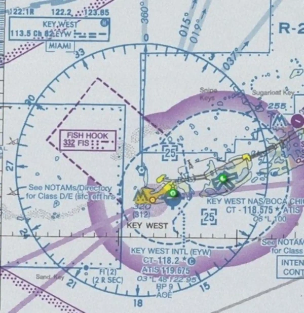
- Part-time Class D effective times are published in the Chart Supplement in Coordinated Universal Time (UTC), also known as "Zulu" time. []
- When anticipating minor variations in hours of operation, Notices to Airmen (NOTAMs) will be issued stating, "This surface area is effective during the specific dates and times established, in advance, by a Notice to Airmen"
- Where a Class D surface area is part-time, the airspace may revert to either a Class E surface area or Class G airspace.
- During the hours the tower is not in operation, the Class E surface area rules or a combination of Class E rules to 700' above the ground level and Class G rules to the surface will become applicable
- When a part–time Class D surface area changes to Class G, the surface area becomes Class G airspace up to, but not including, the overlying controlled airspace.
- The airport listing in the Chart Supplement U.S. will state the part–time surface area status (for example, "other times CLASS E" or "other times CLASS G").
- Normally, the overlying controlled airspace is the Class E transition area airspace that begins at either 700 feet AGL (charted as a magenta vignette) or 1200 feet AGL (charted as a blue vignette).
- Consult applicable Visual Flight Rules (VFR) Sectional or Terminal Area Charts.
- Class D surface areas may be full-time (24-hour tower operations) or part-time.
-
Class Delta Airspace Dimensions:
- The configuration of each Class D airspace area is individually tailored to:
- Contain the intended operations;
- Allow for safe and efficient handling of operations, and;
- When instrument procedures are published, contain Instrument Flight Rules (IFR) arrival operations while between the surface and 1,000 feet above the surface and IFR departure operations while between the surface and the base of adjacent controlled airspace.
- Arrival extensions for instrument approach procedures (IAPs) may be Class D or Class E airspace.
- If all extensions are 2 miles or less, they generally remain part of the Class D surface area
- If any extension is greater than 2 miles, then all extensions become Class E.
-
Horizontal Limits:
- Class D areas are tailored to the area, but the standard radius surrounding those airports that have an operational control tower is 4.4 Nautical Miles (NM)/5 Statute Miles (SM). []
- Exact details, to include the formula for determining Class D airspace width for a given location and the associated class E surrounding area, can be found in the Federal Aviation Administration JO 7400.2 (series):
- The technical formula for class D radius is: R = D/6076 + 3.5.
- For example:
- At Airport A, the distance from the geographic position to the end of the outermost runway is 4,023 feet; therefore, assuming flat terrain, the radius is calculated as: R = 4023/6076 + 3.5 = .662 + 3.5 = 4.162 = 4.2.
- The radius for the 700-foot Class E airspace becomes: 4.2 + 2.5 = 6.7.
- To ensure that the lateral boundary of the Class D area is congruent with the beginning of the 700-foot Class E airspace, the specialist must:
- Search the Class D area's radius circle for the highest terrain.
- Calculate the MSL height of the aircraft by adding 700 feet to the airport elevation.
- Compare MSL altitudes of the aircraft versus the highest terrain to determine if the aircraft has reached the overlying or adjacent controlled airspace. If not, increase the size of the Class D area, as necessary, to contain the departure.
-
Vertical Limits:
- Class D areas generally extend upward from the surface up to and including 2,500 feet AGL.
- In a low density or non-turbo aircraft traffic environment, a vertical limit of 2,500 feet Above Ground Level (AGL) may be excessive, necessitating a lower ceiling.
- Vertical boundaries of class D airspace are delineated with cyan numbers.
- The altitude which the airspace extends is written inside cyan brackets, representing "up to and including" the designated altitude.
- When a - is displayed in front of the number, it means "up to and not including."
- Altitude dimensions are based on AGL but charted in Mean Sea Level (MSL).
- The size of a Class D area, and any necessary extensions, is determined by the use of a 200 feet per NM climb gradient and information obtained from the person responsible for developing instrument procedures. []
- Normally, the person responsible for developing instrument procedures for civil and U.S. Army airports is an FAA Aviation Standards Airspace Evaluation Specialist.
- A military representative handles all other military procedures.
- Generally, separate Class D airspace areas will be established for airports in proximity to each other to eliminate satellite airports as practical.]
- A common boundary line ensures the airspace areas do not overlap.
- When operationally advantageous, the common boundary separating adjacent Class D areas may be eliminated if the areas are contained in an existing Class B or Class C airspace area controlled by the same IFR Air Traffic Control (ATC) facility.
- The configuration of each Class D airspace area is individually tailored to:
-
Class Delta Airspace Depiction:
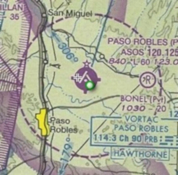
- On Sectional and Terminal charts, Class D airspace areas are depicted with blue segmented lines. [/]
- The primary airport is indicated by a blue symbol.
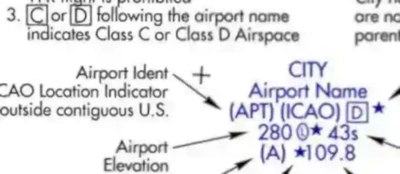
- On IFR En Route Lows, Class D is only recognized by a boxed [D] in the airport information. []
-
Class Delta Airspace Operating Rules & Pilot/Equipment Requirements:
-
Pilot Certification Requirements:
- There is no specific pilot certification required.
- As long as an aircraft meets the equipment requirements below, anyone from a student on up can operate within Class Delta Airspace.
-
Equipment:
- Unless otherwise authorized by ATC, an operable two-way radio is required.
-
VFR Visibility Requirements:
- 3 SM visibility, 500' below, 1,000' above, 2,000' horizontal
- Under Special VFR, if granted by the controller, a pilot may enter or leave Class D Airspace in 1 statute mile of visibility while remaining clear of clouds.
-
Speed Restrictions:
- Unless otherwise authorized or required by ATC, no person may operate an aircraft at or below 2,500' AGL within 4 NM of the primary airport of a Class D airspace area at an indicated airspeed of more than 200 knots (230 mph).
-
Aircraft Separation:
- IFR, Special VFR (SVFR), and runway operations
- No separation provided for VFR operations.
-
Flight Procedures:
- Two-way radio communication (either direct or rapid relay through other facilities which are acceptable to the ATC facility) must be established with the ATC facility providing ATC services, on the publicized frequency, before entry and thereafter maintain those communications while in the Class D airspace.
- When close to the airport, listen for the Automatic Terminal Information System (ATIS)/Automated Weather Observation System (AWOS)/Automated Surface Observation System (ASOS)
- Calls should be initiated far enough from the Class D airspace boundary to preclude entering before two-way communications are established.
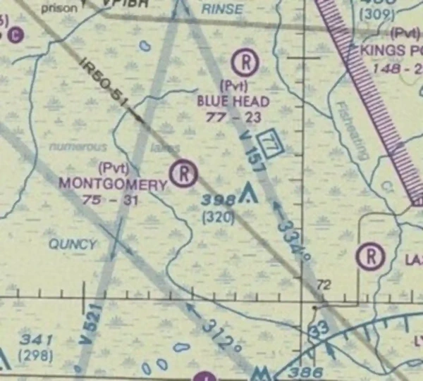
- Pilot: "[Tower], [Callsign], [Position], [Altitude], [Destination], [ATIS/AWOS/ASOS Information] [Request(s)/Intention(s)]"
- Example: "Montgomery Tower, Cessna 1727V, 10-miles to the West, five thousand feet inbound to Montgomery, information Quebec request touch and goes"
- The requirement to maintain two-way radio communications is satisfied when the pilot hears their callsign in response to their call.
- ATC: "[Callsign], [Tower], [Altimeter], [Instructions]"
- Example: "Cessna 1727V, Montgomery Tower, altimeter 30.03, report 3-mile left base for runway 36"
- Example: "Cessna 1727V, standby"
- Example: "Cessna 1727V, remain outside the Class Delta airspace and standby"
- It is important to understand that if the controller responds to the initial radio call without using the aircraft callsign, radio communications are not yet established, and the pilot may not enter the Class D airspace.
- ATC: "Aircraft calling, standby"
- If workload or traffic conditions prevent immediate entry into Class D airspace, the controller will inform the pilot to remain outside the Class D airspace until conditions permit entry.
- ATC: "Aircraft calling, remain outside Class Delta airspace and standby"
- At those airports where the control tower does not operate 24 hours a day, the operating hours of the tower will be listed on the appropriate charts and in the Chart Supplement U.S. During the hours the tower is not in operation, the Class E surface area rules or a combination of Class E rules to 700' AGL and Class G rules to the surface will become applicable.
- Check the Chart Supplement U.S. for specifics.
-
Class Delta Departures:
- Tower provides takeoff, landing, and sometimes taxi clearance (at small airports, ground and tower are the same person)
- No person may, at any airport with an operating control tower, operate an aircraft on a runway or taxiway or takeoff or land an aircraft unless receiving an appropriate clearance from ATC
- An operator may deviate from any provision of this section under the provisions of an ATC authorization issued by the ATC facility having jurisdiction over the airspace concerned
- ATC may authorize a standing deviation or for an individual flight, as appropriate
- From the primary airport or satellite airport with an operating control tower, the pilot must establish and maintain two-way radio communications with the control tower, and thereafter as instructed by ATC while operating in the Class D airspace area.
- From a satellite airport without an operating control tower, the pilot must establish and maintain two-way radio communications with the ATC facility having jurisdiction over the Class D airspace area as soon as practicable after departing.
- When operating out of a satellite airport, contact tower for arrival and departures as soon as practicable
- Each pilot must comply with any departure procedures established for that airport by the FAA
- Unless otherwise required by the prescribed departure procedure or the applicable distance from clouds criteria, each pilot of a turbine-powered airplane and each pilot of a large airplane must climb to an altitude of 1,500' above the surface as rapidly as practicable.
-
Restrictions:
- Arrival Extensions:
- Arrival extensions for IAPs may be Class Delta or Echo airspace
- A Class D area arrival extension must be established to the point where an IFR flight on an instrument approach can be expected to descend to less than 1,000 feet above the surface.
- The width of the extension must be equal to the width of the TERPs primary obstruction clearance area at the widest point where an IFR flight on an instrument approach can be expected to descend to an altitude below 1,000 feet above the surface.
- Extensions must, in all cases, extend to a minimum of 1 NM on each side of the centerline.
- If all arrival extensions are 2 NM or less, they will remain part of the basic Class D area.
- However, if an extension is greater than 2 NM, then all extensions will be Class E airspace.
- Unless required by the applicable distance-from-cloud criteria, each pilot operating a large or turbine-powered airplane must enter the traffic pattern at an altitude of at least 1,500' above the elevation of the airport and maintain at least 1,500' until further descent is required for a safe landing
- Surface Area Arrival Extensions:
- Arrival extensions for instrument approach procedures may be Class D or Class E airspace.
- As a rule of thumb:
- If all extensions are 2 miles or less, they remain part of the Class D surface area.
- If an extension is greater than 2 miles, then all extensions become Class E.
- Surface area arrival extensions are effective during the published times of the surface area.
- For part–time Class D surface areas that revert to Class E airspace, the arrival extensions will remain in effect as Class E airspace.
- For part–time Class D surface areas that change to Class G airspace, the arrival extensions will become Class G at the same time.
- Arrival Extensions:
-
Small Unmanned Aircraft Operations:
- No person may operate a small unmanned aircraft in Class D airspace unless that person has prior authorization from Air Traffic Control (ATC).
- Authorization may be obtained through the FAA's UAS data exchange, Low Altitude Authorization and Notification Capability (LAANC), or the FAA's DroneZone.
- No person may operate a small unmanned aircraft in a manner that interferes with operations and traffic patterns at any airport, heliport, or seaplane base.
- No person may operate a small unmanned aircraft in Class D airspace unless that person has prior authorization from Air Traffic Control (ATC).
-
-
Weather Observations and Reporting:
- Weather observations are taken at the primary airport during the times and dates the Class D airspace is active by either a federally certified weather observer or a federally commissioned automated weather observing system.
- This includes all FAA and National Weather Service (NWS) approved and certified weather reporting systems.
- The weather observer will take routine (hourly) and special observations, called METARs
- An automated weather observing system can provide continuous weather observations, called AWOS/ASOS.
- Scheduled record and special observations from weather observers or automated weather reporting systems must be made available to the ATC facility(s) having control jurisdiction over the Class D designated surface area.
- This can be accomplished through Flight Service Station (FSS), Longline Dissemination, NWS, or other FAA-approved sources.
- Facilities that require weather reports from satellite airports may enter into a letter of agreement (LOA) with the associated FSS, airline/contract observer, airport management, etc.
- At ATC sites where non-Federal employees perform weather duties, the appropriate FAA office supervises reporting and dissemination requirements applicable to National Weather Service and FAA publication standards.
- In facilities where direct access to automated weather observing systems is not available, controllers will apply the provisions of FAAO 7110.65, Air Traffic Control.
- Should these services be unavailable, a NOTAM will be issued.
- Weather observations are taken at the primary airport during the times and dates the Class D airspace is active by either a federally certified weather observer or a federally commissioned automated weather observing system.
-
Class Delta Airspace Conclusion:
- Federal Aviation Regulation 91.155 governs VFR ceiling and visibility minimums.
- Class Delta Airspace areas do not provide radar services, as in Class Bravo or Charlie airspace.
- Unless otherwise authorized or required by the Air Traffic Control (ATC) facility having jurisdiction over the Class D airspace area, each person operating an aircraft in Class D airspace must comply with the applicable provisions of FAR 91.129
- Each person must comply with Federal Aviation Regulation (FAR) 91.126 and 91.127.
- Local FAA offices review Class Delta Airspace areas biennially to evaluate safety and policy compliance.
- Remember to comply with all noise abatement procedures found in the Chart Supplement U.S..
- The primary airport is always the airport for which the Class D airspace area is designated, whereas the satellite airport is any other airport within the Class D airspace area
- See also: CFI Notebook.net - Aviation Roles.
- Turbine aircraft will operate at 1,500' AGL in the pattern until in a position to make a safe landing
- Circle to the left and avoid the flow of fixed-wing traffic if operating a helicopter
- Each pilot operating a large or turbine-powered airplane approaching to land on a runway served by an instrument approach procedure with vertical guidance, if the airplane is so equipped, must:
- Operate that airplane at an altitude at or above the glide path between the published final approach fix and the decision altitude (DA), or decision height (DH), as applicable; or
- If compliance with the applicable distance-from-cloud criteria requires glide path interception closer in, operate that airplane at or above the glide path, between the point of interception of glide path and the DA or the DH
- Where the FAA has established a formal runway use program, each pilot of a large or turbine-powered airplane assigned a noise abatement runway by ATC must use that runway. However, consistent with the final authority of the pilot in command concerning the safe operation of the aircraft, ATC may assign a different runway if requested by the pilot in the interest of safety.
- If two-way radio communications are lost during operations inside of class Delta airspace, follow the appropriate lost communication procedures
- Still looking for something? Continue searching:


Class Echo Airspace
- Class E (also called "Class E") Airspace is controlled airspace designated to serve various terminal or en route purposes.
- Class Echo airspace services are available, provided by an Air Route Traffic Control Center (ARTCC).
- Class E airspace dimensions contain Instrument Flight Rules and Visual Flight Rules operations within the terminal area.
- Class E airspace is depicted on several navigational charts.
- Operations in Class Echo airspace require adherence to relevant operating rules & pilot equipment requirements.
- Together, these operating procedures enable the function of Class Echo airspace.
-
Class Echo Air Traffic Services:
- Each pilot of an aircraft must comply with any traffic patterns established for that airport in part 93.
- Unless authorized or required by ATC, no person may operate an aircraft to, from, through, or on an airport having an operational control tower unless two-way radio communications are maintained.
- Communications must be established before 4 NM from the airport, up to and including 2,500' AGL.
- If the aircraft radio fails in flight, the pilot in command may operate that aircraft and land if weather conditions are at or above VFR weather minimums, visual contact with the tower is maintained, and a clearance to land is received.
- If the aircraft radio fails while in flight under IFR, the pilot must comply with IFR two-way radio communications failure procedures.
-
Class Echo Airspace Dimensions:
-
Horizontal Limits:
- The horizontal limits of Class Echo airspace include:
- The 48 contiguous States, including the waters within 12 miles from the coast of the 48 contiguous States;
- The District of Columbia;
- Alaska, including the waters within 12 miles off the coast of Alaska;
- Horizontal limits exclude the Alaska peninsula west of long 160°00'00''W and the airspace below 1,500 feet above the earth's surface unless specifically designated.
- The horizontal limits of Class Echo airspace include:
-
Vertical Limits:
- Except when designed differently per the functions of Class E Airspace (defined below), Class E airspace is that airspace extending upward from 14,500' MSL to, but not including, 18,000 feet MSL, excluding:
- The airspace below 1,500' above the surface of the earth unless specifically designated lower (for example, in mountainous terrain higher than 13,000 feet MSL).
- Class E begins again at 60,000' MSL and continues up to unlimited.
- Except when designed differently per the functions of Class E Airspace (defined below), Class E airspace is that airspace extending upward from 14,500' MSL to, but not including, 18,000 feet MSL, excluding:
-
-
Class Echo Airspace Depiction:
- Class E airspace below 14,500' MSL is charted on the following charts: []
- VFR Sectionals.
- IFR En Route Low Altitude, and.
- Terminal Area Charts (where appropriate).
- Class E airspace below 14,500' MSL is charted on the following charts: []
-
Class Echo Operating Rules & Pilot/Equipment Requirements:
-
Pilot Certification Requirements:
- No specific certificate required.
-
VFR Visibility Requirements:
- Below 10,000' MSL: 3 SM visibility, 500' below, 1,000' above, 2,000' horizontal
- Above 10,000' MSL: 5 SM visibility, 1,000' below, 1,000' above, 1 SM horizontal.
-
Equipment:
- Unless otherwise authorized by ATC:
- An operable radar beacon transponder with automatic altitude reporting capability and operable ADS-B Out equipment are required at and above 10,000 feet MSL within the 48 contiguous states and the District of Columbia, excluding the airspace at and below 2,500' above the surface, and.
- Operable ADS-B Out equipment at and above 3,000 feet MSL over the Gulf of Mexico from the coastline of the United States out to 12 nautical miles. []
- The airspace described here is specified in 14 CFR 91.225 for ADS-B Out requirements. However, 14 CFR 91.215 does not include this airspace for transponder requirements.
- Unless otherwise authorized by ATC:
-
Flight Procedures:
- ATC clearance for IFR, all require radio contact.
-
Aircraft Separation:
- Separation is provided for IFR, SVFR, and runway operations
- VFR separation is not provided unless flight following is being used.
-
Speed Restrictions:
- 250 knots below 10,000' MSL.
-
Regulation:
- Unless otherwise required by part 93 or unless otherwise authorized or required by the ATC facility having jurisdiction over the Class E airspace area, each person operating an aircraft on or in the vicinity of an airport in a Class E airspace area must comply with the requirements of FAR 91.126.
-
Small Unmanned Aircraft Operations:
- No person may operate a small unmanned aircraft within the lateral boundaries of the surface area of Class E airspace designated for an airport unless that person has prior authorization from Air Traffic Control (ATC).
- Authorization may be obtained through the FAA's UAS data exchange, Low Altitude Authorization and Notification Capability (LAANC), or the FAA's DroneZone.
- No person may operate a small unmanned aircraft in a manner that interferes with operations and traffic patterns at any airport, heliport, or seaplane base.
- No person may operate a small unmanned aircraft within the lateral boundaries of the surface area of Class E airspace designated for an airport unless that person has prior authorization from Air Traffic Control (ATC).
-
-
Functions of Class Echo Airspace:
- Class E airspace can be tailored for specific purposes and remembered with the acronym "FEETSO 14-500:"
-
Federal Airways:
- The VOR and L/MF (non-directional radio beacons) Airway System consists of airways designated from 1,200' above the surface (or in some instances higher) up to but not including 18,000' MSL.
- VFR Sectionals and IFR Enroute Low Altitude Charts depict these airways [/]
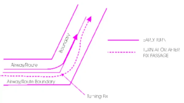
- The altitude limits of a victor airway should not be exceeded except to effect transition within or between route structures.
- Federal airways are based on a centerline that extends from one navigational aid (NAVAID)/waypoint/fix/intersection to another NAVAID/waypoint/fix/intersection specified for that airway.
- A Federal airway includes the airspace within parallel boundary lines 4 NM to each side of the centerline.
- The VOR airways are classified as Domestic, Alaskan, and Hawaiian
- As in all instrument flight, courses are magnetic, and distances are in NM.
- Except in Alaska, the VOR airways are:
- Predicated solely on VOR or VORTAC navigation aids;
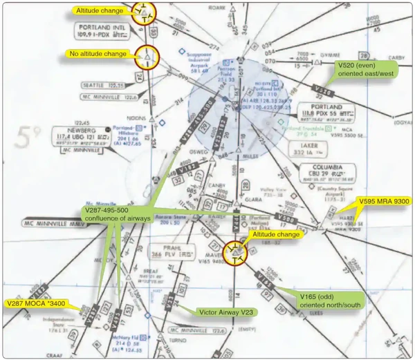
- Identified by a "V" (Victor) followed by the airway number (for example, V12).
- Typically, Victor airways are given odd numbers when oriented north/south and even numbers when oriented east/west.
- Depicted in black on aeronautical charts;
- Segments of VOR airways in Alaska are based on L/MF navigation aids and charted in brown instead of black on en route charts.
- A segment of an airway which is common to two or more routes carries the numbers of all the airways which coincide for that segment.
- When such is the case, pilots filing a flight plan need to indicate only that airway number for the route filed.
- A pilot who intends to make an airway flight, using VOR facilities, will simply specify the appropriate "victor" airway(s) in the flight plan. For example, if a flight is to be made from Chicago to New Orleans at 8,000 feet, using omniranges only, the route may be indicated as "departing from Chicago-Midway, cruising 8,000 feet via Victor 9 to Moisant International." If flight is to be conducted in part by means of L/MF navigation aids and in part on omniranges, specifications of the appropriate airways in the flight plan will indicate which types of facilities will be used along the described routes, and, for IFR flight, permit ATC to issue a traffic clearance accordingly. A route may also be described by specifying the station over which the flight will pass, but in this case since many VORs and L/MF aids have the same name, the pilot must be careful to indicate which aid will be used at a particular location. This will be indicated in the route of flight portion of the flight plan by specifying the type of facility to be used after the location name in the following manner: Newark L/MF, Allentown VOR.
- Pilots must fly the centerline of an airway or a direct route between fixes. []
- Inside of 50 NM, the width will extend 4 NM from centerline (8 NM wide)
- Outside of 50 NM, the accuracy of NAVAIDs (4.5° tolerance) will determine the width of the airway
- With respect to position reporting, reporting points are designated for VOR Airway Systems.
- Flights using Victor Airways will report over these points unless advised otherwise by ATC.
- A Federal airway does not include the airspace of a prohibited area.
- Colored Airways:
- The L/MF airways (colored airways) are predicated solely on L/MF navigation aids and are depicted in brown on aeronautical charts and are identified by color name and number (e.g., Amber One).
- Green and Red airways are plotted east and west.
- Amber and Blue airways are plotted north and south.
- The use of TSO-C145 (as revised) or TSO-C146 (as revised) GPS/WAAS navigation systems is allowed in Alaska as the only means of navigation on published air traffic service (ATS) routes, including those Victor, Terminal Transition Routes (T-Routes), and colored airway segments designated with a second minimum en route altitude (MEA) depicted in blue and followed by the letter G at those lower altitudes. The altitudes so depicted are below the minimum reception altitude (MRA) of the land-based navigation facility defining the route segment, and guarantee standard en route obstacle clearance and two-way communications. Air carrier operators requiring operations specifications are authorized to conduct operations on those routes in accordance with FAA operations specifications.
- The VOR and L/MF (non-directional radio beacons) Airway System consists of airways designated from 1,200' above the surface (or in some instances higher) up to but not including 18,000' MSL.
-
Class Echo Extension to Surface Area:
- Class E airspace may be designated as extensions to Class B, Class C, Class D, and Class E surface areas.
- Class E airspace extensions begin at the surface and extend up to the overlying controlled airspace.
- The extensions provide controlled airspace to contain standard instrument approach procedures without imposing a communications requirement on pilots operating under VFR.
- Surface area arrival extensions become part of the surface area and are in effect during the same times as the surface area.
- In the example shown to the right, you see the Class echo extension connects with Class Delta airspace. []
- When a Class C or Class D surface area is not in effect continuously (for example, where a control tower only operates part-time), the surface area airspace will change to either a Class E surface area or Class G airspace. In such cases, the "Airspace" entry for the airport in the Chart Supplement U.S. will state "other times Class E" or "other times Class G." When a part-time surface area changes to Class E airspace, the Class E arrival extensions will remain in effect as Class E airspace. If a part–time Class C, Class D, or Class E surface area becomes Class G airspace, the arrival extensions will change to Class G at the same time.
-
Class Echo En-route Domestic Area:
- Echo airspace that extends upward from a specified altitude and are used for en-route domestic airspace areas to provide controlled airspace where there is a requirement to provide IFR en route ATC services but the Federal Airway does not exist and would be inadequate.
- Depicted on the outside of the transition area where Class Echo starts at 1,200' AGL.
- The lateral extend is identical to that of a federal airway.
-
Class Echo Transition Area:
- Class E airspace areas may be designated for transitioning aircraft to/from the terminal or en route environment. []
- Class E transition areas extend upward from either 700 feet AGL (shown as magenta vignette on sectional charts) or 1,200 feet AGL (blue vignette) and are designated for airports with an approved instrument procedure.
- The 700-foot/1200-foot AGL Class E airspace transition areas remain in effect continuously, regardless of airport operating hours or surface area status.
- Do not confuse the 700-foot and 1200-foot Class E transition areas with surface areas or surface area extensions.
- Class E airspace areas may be designated for transitioning aircraft to/from the terminal or en route environment. []
-
Class Echo Surface Area Designated For An Airport:
- Class E surface areas extend upward from the surface to a designated altitude, or to the adjacent or overlying controlled airspace. The airspace will be configured to contain all instrument procedures. []
- To qualify for a Class E surface area, the airport must have weather observation and reporting capability, and communications capability must exist with aircraft down to the runway surface.
- A Class E surface area may also be designated to accommodate part-time operations at a Class C or Class D airspace location (for example, those periods when the control tower is not in operation).
- Pilots should refer to the airport page in the applicable Chart Supplement U.S. for surface area status information.
- Class E surface areas extend upward from the surface to a designated altitude, or to the adjacent or overlying controlled airspace. The airspace will be configured to contain all instrument procedures. []
-
Class Echo Offshore (beyond 12NM):
- There are Class E airspace areas that extend upward from a specified altitude to, but not including, 18,000 feet MSL and are designated as offshore airspace areas. []
- This areas offshore control of incoming and outgoing international flights.
- These areas provide controlled airspace beyond 12 miles from the coast of the U.S. in those areas where there is a requirement to provide IFR en route ATC services and within which the U.S. is applying domestic procedures.
-
Class Echo - 14,500:
- Remember, 14,500 is the standard start of class E airspace (14,500-17,999)
-
Class Echo Airspace Conclusion:
- Federal airways and low-altitude RNAV routes are Class E airspace areas and, unless otherwise specified, extend upward from 1,200 feet AGL to, but not including,18,000 feet MSL.
- Note there is also jet route and Q-route systems which exists in Class Alpha Airspace as part of the high-altitude enroute structure.
- Federal Aviation Regulation 91.155 governs VFR ceiling and visibility minimums.
- Remember to comply with all noise abatement procedures, found in the Chart Supplement U.S..


Controlled Airspace Interactive Scenario
Interactive Scenario
Loading scenario details...
Decision 1
0%
Scenario Complete
Controlled Airspace Knowledge Check
Private Pilot
Core Knowledge Review
Review the foundational knowledge, key concepts, and practical considerations for Controlled Airspace.
Foundational
Immediate Feedback
Answer Explanations
Commercial Pilot
Advanced Application
Apply your knowledge of Controlled Airspace to advanced operational scenarios, risk management, and aeronautical decision-making.
Advanced
Scenario Based
Risk Management
Why Take a Quiz?
Quizzes reinforce key concepts, identify knowledge gaps, and build confidence for real-world decisions in the cockpit.
Controlled Airspace Conclusion
- Still looking for something? Continue searching:
Controlled Airspace References
- Advisory Circular (90-114) Automatic Dependent Surveillance-Broadcast Operations
- Airnav.com.
- Aeronautical Information Manual (3-2-2) Class A Airspace.
- Aeronautical Information Manual (3-2-3) Class B Airspace.
- Aeronautical Information Manual (3-2-4) Class C Airspace.
- Aeronautical Information Manual (3-2-5) Class Delta Airspace.
- Aeronautical Information Manual (3-2-6) Class E Airspace.
- Aeronautical Information Manual (4-1-8) Approach Control Service for VFR Arriving Aircraft.
- Aeronautical Information Manual (4-1-18) Terminal Radar Services for VFR Aircraft.
- Aeronautical Information Manual (4-1-20) Transponder and ADS-B Out Operation.
- Aeronautical Information Manual (4-3-2) Airports with an Operating Control Tower.
- Aeronautical Information Manual (5-3-4) Airways and Route Systems.
- AeroNav Products - Aeronautical Chart User's Guide.
- AOPA - Know Before You Go: Navigating Today's Airspace.
- BoldMethod - The VFR Pilot's Guide For Landing At Busy Airports.
- Federal Aviation Administration - Pilot/Controller Glossary.
- Federal Aviation Administration Order 7400.2 Procedures for Handling Airspace Matters.
- Federal Aviation Administration Order (7400.9) Airspace Designations and Reporting Points.
- Federal Aviation Administration - National Flight Data Digest (NFDD).
- Federal Aviation Regulations (Part 71 subpart A) Class A Airspace.
- Federal Aviation Regulations (Part 71 subpart B) Class A Airspace.
- Federal Aviation Regulations (Part 71 subpart C) Class C Airspace.
- Federal Aviation Regulations (Part 71 subpart D) Class D Airspace.
- Federal Aviation Regulations (Part 71 subpart E) Class E Airspace.
- Federal Aviation Regulations (61.94) Student pilot seeking a sport pilot certificate or a recreational pilot certificate: Operations at airports within, and in airspace located within, Class B, C, and D airspace, or at airports with an operational control tower in other airspace.
- Federal Aviation Regulations (61.95) Operations in Class B airspace and at airports located within Class B airspace..
- Federal Aviation Regulations (61.101(d)) Recreational pilot privileges.
- Federal Aviation Regulations (61.325) How do I obtain privileges to operate a light-sport aircraft at an airport within, or in airspace within, Class B, C, and D airspace, or in other airspace with an airport having an operational control tower.
- Federal Aviation Regulations (91.127) Operating on or in the vicinity of an airport in Class E airspace.
- Federal Aviation Regulations (91.129) Operations in Class D Airspace.
- Federal Aviation Regulations (91.130) Operations in Class C Airspace.
- Federal Aviation Regulations (91.131) Operating in Class B airspace.
- Federal Aviation Regulations (91.135) Class A operations.
- Federal Aviation Regulations (91.181) Course to be flown.
- Federal Aviation Regulations (91.185) IFR communications failure.
- Federal Aviation Regulations (91.215) ATC transponder and altitude reporting equipment and use.
- Federal Aviation Regulations (91.225) Automatic Dependent Surveillance-Broadcast (ADS-B) Out equipment and use.
- Instrument Flying Handbook (1-2) Airspace Classification.
- Sky Vector.